Showing 19 items matching redan road
-
 Glen Eira Historical Society
Plan - Nettalie
... Redan Road... Hawthorn Road Cemetery Road Bambra Road Redan Road Kambrook Road ...An A4 photocopy of the 'Plan of the Caulfield Road District' dated 1867. This plan shows the location of the properties owned by A Shaw and Blundell on Balaclava and Orrong Roads where Nettalie is situated. The plan includes all the landowners listed where their property was, the street names and other landmarks of 1867 including railways, hotels and reserves.caulfield, caulfield north, elsternwick, st kilda east, parish of prahran, parish of moorabbin, caulfield road district, melbourne and brighton railway, rosstown railway, elsternwick railway station, caulfield railway station, rosstown railway station, murrumbeena railway station, baptist church, paddy’s swamp reserve, cemetery reserve, leman swamp reserve, caulfield racecourse reserve, brighton cemetery, the vine caulfield hotel, the tam o’shanter hotel, melbourne hunt hotel, royal hotel, hotham street, horne street, nepean highway, north road, orrong road, dandenong road, princes highway, kooyong road, alma road, inkerman road, balaclava road, glen eira road, glen huntly road, hawthorn road, cemetery road, bambra road, redan road, kambrook road, neerim road, booran road, racecourse road, grange road, koornang road, murrumbeena road, crosbie road, kangaroo road, poath road, ford w, lempriere, cople j, riddell j c, manifold j, testar t, billing r h, semple, blundell, shaw a, butchart g, stephen j w, stephen g sir, hart j, duncan g, blackie r, stephen f, mccombie t, woollaston h, higgins j, lloyd j c, daish j, mcleod j, hughes d, wilson a, jamieson g, webb g h, renwick s, pennington h, dunn j, kirkpatrick w, ricketson w, toad a, sayce j, watts t, widgery, store, guess j, anketell j, clack j, sissen w, clayton g, dickson d, bevan j, hart t, anderson j, hart mrs, webb h, masters s, waghorn j, hemming c, hiam c, farquhar w, newing t, payne t, cooper r, snipe s, chambers j, forster w, summers r, harriman b, warrick, o’connell, long j, peck r, cochrane c, murray ross w, evans c, kennedy j, maclean n, forster, lyall w, dean j, newton h, looker w, baker c, johnston, crosbie j, kerr, jones, parr, nelson c, montgomery l, parsons w, james j c, sibon c, smith sydney w, plans, maps, land subdivisions, land use, settlements, roads and streets, hotels, churches, police stations, post offices, land surveys, railway stations, railways, schoolhouses, commerce, clergy residences, official buildings, local government, road districts -
Glen Eira Historical Society
Letter - Newing, Thomas R
... Redan Road... Robert Redan Road Caulfield ‘Ellington’ House names Brighton ...Eight items about Thomas Robert Newing: 1/Four letters between Mr. Ballantyne and Patricia M. Lamb, requesting information on her great great grandfather. 2/Two handwritten articles about Thomas Robert Newing, one taken from Sand Swamp and Health, the other unknown and undated, but both appear to respond to first two letters. 3/Handwritten details about inscriptions on gravestones at Brighton Cemetery of Alexander MacGeorge, and other information obtained from Cemetery curator, date unknown, author unknown, but appear to respond to third letter. 4/Handwritten research notes by Claire Barton dated 30/04/2013 concerning the Newing family and other owners of ‘Ellington’ and adjacent properties.newing thomas robert, redan road, caulfield, ‘ellington’, house names, brighton cemetery, bowles elizabeth, shire president, cook c, horseriders, councillors, lamb patricia m, ballantyne r, neville street, newington street -
 Federation University Historical Collection
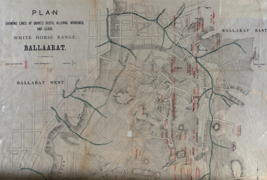
Plan, White Horse Range Ballarat, 1885, 06/1885
Two plans .1) Plan of the Ballarat Goldfields showing leads, rivers, streets and topography. Quartz reefs include: Yorkshire, Try Again, Promised Land, Western Slates, Norwegian, Robert's Lode, Finn's, Band and albion, Rothschild, Old Post Office, Queen Lode. Leads include: Navy jacks, Gays, Canadian, Prince Regent, Sailors Gully, White Horse, Little White Horse, Milkmans, Nightingale, Golden Point, Gravel Pits. Scale is 8 Chains to 1 inch .2) Plan showing lines of quartz reefs, alluvial workings and leads, White Horse Range, Ballarat. Leads include White Horse LEad, Little White Horse Lead, One Eye Gully, Terrible Lead, Sailor's Gully, Canadian Lead, Prince Regent Gully, Canadian Lead, Cavs Lead, Navy jacks Lead, Eureka Lead, Old Gravel Pits Lead, Gravel Pits Lead, Nightingale Lead, Malakoff Lead, Milkmans Lead, Redan Lead, Woolshed Lead, Jacksons Lead, Winters Lead, SCtochman's Lead, Canadian Lead. Reefs include: Promised Land, Daniash, Sir Garnet Wolsley, Norwegian, Rothschile, Band and Albion, Finns, Llanberis, Roberts Lode, Tynworths and Black Hill, Oregan, Yorkshire, Try Again, Yorkshire, Post Office, Clarke's, Western Slates, Black Slate, Danks Slates, Eastern Slates, Queen's Lode, Fire Brigade. Mines include Red Streak, New Chum, Tinworths, Woah Hawp, Normanby, Speedwell, Llanberris Extended, Llanberis, Last Chance, Major, Countess, Pioneer and a number of batteries along Main Road Hills include: Mount Clear, Pennyweight Hill, Sovereign Hillballarat, plan, white horse range, white horse, goldfields, mines, reefs, indicators, leigh river, cgt, tinworth, mining -
 Victorian Interpretive Projects Inc.
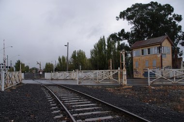
Photograph, Elaine Murphy, Ballarat Railway Gates, 03/05/2012
Railway track running through the gates at Humffray Street (North) Ballarat. Signal box in foreground and Ballarat Station in the BackgroundRailway track going through gates at Humffray Street (North), Ballarat. Signal box on the right of photo, Ballarat station in background. railways, gates, building, signal box, lights, tracks, train, ballarat station, lines, road, rust, lights, ballarat, graffiti. -
 Victorian Interpretive Projects Inc.
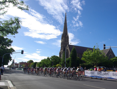
Photograph - Colour, Clare Gervasoni, Australian Road Cycling Championships, Ballarat, 05/01/2012
Each year the national cycling championships are held at Ballarat.Colour photograph in digital format of a number of female bicycle riders taking part in the National Road Cycling Championships at Ballarat. The church is St Andrew's Kirk, Sturt Street, Ballaratballarat, st andrew's, cycling, bicycle -
 Victorian Interpretive Projects Inc.
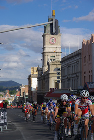
Photograph - Colour, Clare Gervasoni, National Cycling Championships, Ballarat, 05/01/2012
Each year the National Cycling awards are held in Ballarat.Colour photograph in digital format showing a number of female riders in the National Cycling Road Race, 2012. They are riding on Sturt Street and the Ballarat Town Hall is in the background.ballarat, ballarat town hall, cycling, bicycle -
 Victorian Interpretive Projects Inc.
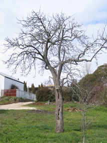
Photograph - Colour, Clare Gervasoni, Fabrizio Crippa's Pear Tree, Hepburn Springs, 27/08/2006
Fabrizio Crippa of Monza, Italy built a double storey villa in 1864 on the Main Road in Hepburn Springs. The surrounding land was planted with vines and fruit trees. The pear tree is most probably one of Fabrizio Crippa's original plantings.Am old pear tree stands in a garden with a building in the back ground. hepburn, hepburn springs, pear, villa parma, parma house, crippa, fabrizio crippa -
 Victorian Interpretive Projects Inc.
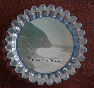
Image of souvenir ware, Apollo Bay
Apollo Bay is located between Wye River and Cape Otway on Victoria's scenic coastal route, the Great Ocean Road. In the 1840s the Henty brothers established a whaling station at Point Bunbury on the western end of the bay. The bay was named by Captain Loutit in 1845 when he sheltered his vessel, the Apollo during a storm. (http://en.wikipedia.org/wiki/Apollo_Bay)A coloured picture of a coastline attached to a glass butter plate. The coastline is Cape Patton, Apollo Bay, Victoria"Apollo Bay"apollo bay, beach, coast, souvenir -
 Victorian Interpretive Projects Inc.
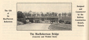
Image, MacRobertson's Bridge, 1934
Confectionery king MacPherson Robertson personally funded the £19 000 cost of the steel arch MacRobertson or Grange Road Bridge (1934) as a gift to Victoria for its centenary. (http://www.emelbourne.net.au/biogs/EM00234b.htm)A steel bridge over the Yarra River, Melbourne. The bridge was funded by MacPherson Robertson.macrobertson, bridge -
 Victorian Interpretive Projects Inc.
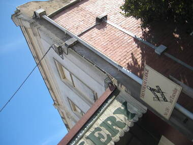
Photograph - colour, Clare Gervasoni, Trentham Masonic Lodge, 2012
Photograph of the first floor of a brick shop in the Main Road of Trentham. The first floor is the Trentham Masonic Lodge.trentham, freemason, trentham masonic lodge, masonic lodge -
 Victorian Interpretive Projects Inc.
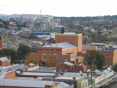
Photograph - Colour, Lisa Gervasoni, Ballarat Civic Hall, 2006, 14/06/2006
The Ballarat Civic Hall was built in the 1950s. The photographs were taken from the tower of the Ballarat Town Hall in 2006.Three photographs taken from the Ballarat Town Hall tower featuring Ballarat Civic Hall, a cream brick building built in the 1950s. .1) The cream brick Ballarat Civic Hall dominates this photograph, with Creswick road visible on the left. .2) The cream brick Ballarat Civic Hall is to the right of this photograph, with Creswick road visible on the left. The Bunge silos are in the centre. .3) Armstrong Street North, with Ballarat Civic Hall in the centre ballarat civic hall, civic hall, ballarat, creswick road, armstrong street north -
 Victorian Interpretive Projects Inc.
Photograph - Colour, LJ Gervasoni, Nevins's Road, Yandoit Creek, 2004, 26/06/2004
The Gervasoni settled at Yandoit Creek in the 1860sDigital colour photograph of drystone buildings associated with the Gervasoni family at Yandoit Creek.ndoit, yandoit creek, yandoit hill, drystone, gervasoni -
 Victorian Interpretive Projects Inc.
Photograph - Colour, Clare Gervasoni, View from Nevin's Road towards the Swiss Italian Enclave at Yandoit Creek, 2014, 12/2013
For a 2004 comparative view see http://victoriancollections.net.au/items/52fdd83d2162ef1820380448 Two colour photographs showing the view from Nevin's Road towards the Swiss Italian Enclave at Yandoit Creek, 2014yandoit, yandoit creek, yandoit hill, gervasoni, drystone, swiis/italian -
 Victorian Interpretive Projects Inc.
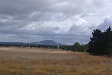
Photograph - Colour, Clare Gervasoni, Mount Buninyong from the Geelong side, 2014, 15/03/2014
View of Mount Buninyong from the road between Buninyong and Geelong -
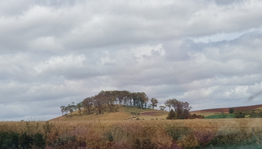
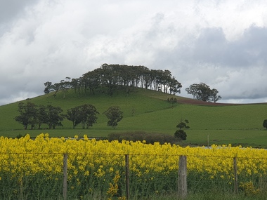
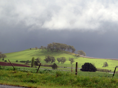 Victorian Interpretive Projects Inc.
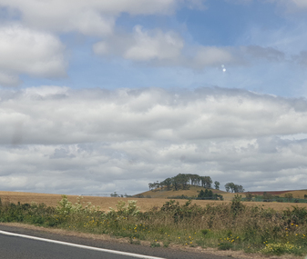
Photograph - Photograph - Colour, Clare Gervasoni, Wombat Hill near Boundary Church Road, Newlyn, 2014, 13/10/2014
Treed Hill on the Daylesford-Dean-Ballarat Road. It is Wombat Hill.hill, boundary church road, wombat hill, newlyn -
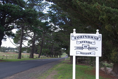 Victorian Interpretive Projects Inc.
Photograph - Colour, Corindhap Avenue of Honour, 2015, 23/08/2015
"The Corindhap Avenue of Honour, located on Colac-Ballarat Road, was planted to commemorate those who served in the First World War. The avenue was planted on the 15th September 1917 as a mark of admiration for the men of Corindhap who had left to fight in the Great War." (Ballarat Courier, 19th September 1917) A number of colour photographs showing trees from the Corindhap Avenue of Honour. The trees are not in good condition, and one has fallen over. corindhap, corindhap avenue of honour, avenue of honour, world war one -
 Victorian Interpretive Projects Inc.
Photograph - Photograph - Colour, Clare Gervasoni, Wombat Hill near Boundary Church Road, Newlyn, 2020
Treed Hill on the Daylesford-Dean-Ballarat Road. It is Wombat Hill.hill, boundary church road, wombat hill, newlyn -
 Victorian Interpretive Projects Inc.
Photograph - Photograph - Colour, Clare Gervasoni, Wombat Hill near Boundary Church Road, Newlyn, 2019, 2020
Treed Hill on the Daylesford-Dean-Ballarat Road. It is Wombat Hill.hill, boundary church road, wombat hill, newlyn -
 Victorian Interpretive Projects Inc.
Photograph - Photograph - Colour, Clare Gervasoni, Wombat Hill near Boundary Church Road, Newlyn, 2020
Treed Hill on the Daylesford-Dean-Ballarat Road. It is Wombat Hill.hill, boundary church road, wombat hill, newlyn