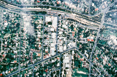
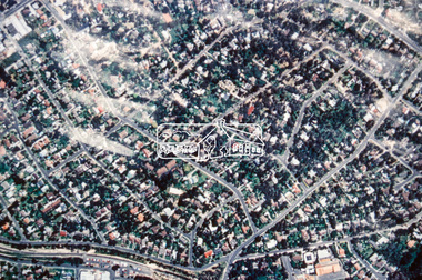
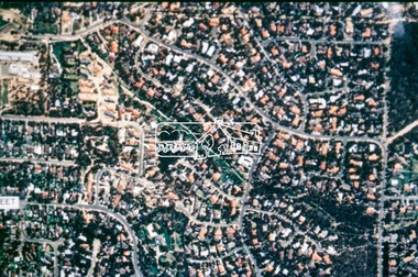
Showing 637 items matching aerial photo
-
 Tatura Irrigation & Wartime Camps Museum
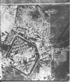
Photograph, camp 1 aerial photo 1946
... camp 1 aerial photo 1946...camp 1 aerial photo 1946... Tatura the-murray Photograph camp 1 aerial photo 1946 camp 1 ...camp 1 aerial photo 1946, photograph -
 Eltham District Historical Society Inc
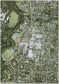
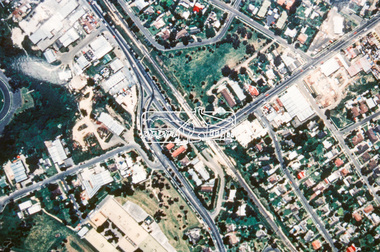
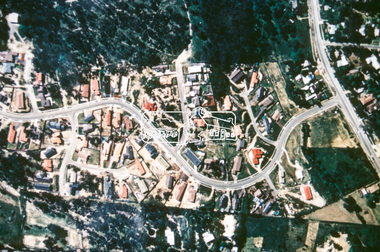
Photograph - Digital Photograph, MetroMap, Aerial Photo: Eltham Town Centre, 2021
... Aerial Photo: Eltham Town Centre, 2021...Aerial Photo... melbourne Digital Photograph Photograph Aerial Photo: Eltham Town ...Map acquired by Nillumbik Shire Council as part of an investigation into proposed transport upgrades.aerial photo, eltham town centre -
 Tatura Irrigation & Wartime Camps Museum
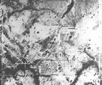
Photograph, Aerial photo of camp 3 1946
... Aerial photo of camp 3 1946...aerial photo of camp 3...Photograph Photograph Aerial photo of camp 3 1946 Black ...Aerial photograph, taken in 1946 of the Rushworth internment camp.Black and white aerial photograph of camp 3 Rushworth showing layout of the camp.aerial photo of camp 3, taken in 1946, rushworth internment camp, aerial photographs, victorian internment camps -
 Ringwood and District Historical Society
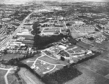
Photograph, Aerial photo of Cherrydene Estate in foreground off Oban Rd, Ringwood - c.1967
... Aerial photo of Cherrydene Estate in foreground off Oban Rd...Written on back of photograph, "Aerial photo of Cherry Dene... Road Ringwood North melbourne Photograph Aerial photo ...Written on back of photograph, "Aerial photo of Cherry Dene Estate in foreground, c1967 off Oban Rd." -
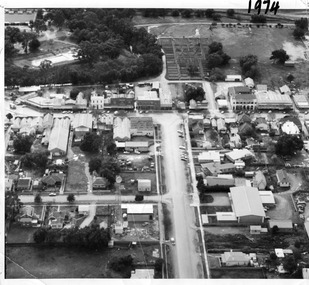 Charlton Golden Grains Museum Inc
Photograph, Aerial photo of Armstrong St, Charlton
... Aerial photo of Armstrong St, Charlton...Aerial photo looking down Armstrong St. Camp street...Black & white aerial photo looking down a broad street... melbourne Photograph Photograph Aerial photo of Armstrong St ...Aerial photo looking down Armstrong St. Camp street on the left, Shire Hall on the right. High St runs across the photo. The Avoca River is visible in the top LH side. The swimming pool and bowling green is above the rive. On High St (from L-R) Dr Surgery, H Bath Chemist, Grocery, Roy Dobson, Hairdresser, Stowe's, Westpac Bank (two storey white building), Dillon's Building, Globe Hotel, Charlton Club, butcher shop, Arundell's shoe shop, Watson's Stock & Station Agency, Bullock's grocery, Williams St (Curtin Ave), Bannon's Butchers, East Charlton Hotel, MB Luth & Co, Lou's cafe. The old sale yards are at the end of Williams Street. Camp St lower side (from L-R) Court House, Police residence, Police Station, Telecom on corner. The photo is thought to be taken from Ossie Sanderson's airplane in 1974.Black & white aerial photo looking down a broad street that ends in a t-intersection. There is a street that comes off to the left about 1/3 of the way up the photo. There is a large building directly opposite this street. In the upper right there is a two storey building with arches on its verandah. In the upper LH side there is a swimming pool and bowling greens. -
 Port Melbourne Historical & Preservation Society
Postcard - Aerial view of piers at Port Melbourne, Aerial photo of Port Melbourne, c. 1922
... Aerial photo of Port Melbourne...Sepia picture postcard, unused, aerial photo showing ships... Melbourne Postcard Aerial photo of Port Melbourne Sepia picture ...Sepia picture postcard, unused, aerial photo showing ships at Port Melbourne: Princes, Station and Town Pierstransport - shipping, piers and wharves - station pier, piers and wharves - princes pier, piers and wharves - town pier -
 Stawell Historical Society Inc
Photograph, Central Park -- Aerial Photo 2007 -- Coloured
... Central Park -- Aerial Photo 2007 -- Coloured...Central Park (Aerial Photo) 2007... grampians Photograph Central Park -- Aerial Photo 2007 -- Coloured ...Central Park (Aerial Photo) 2007stawell sport -
 Stawell Historical Society Inc
Photograph, Central Park -- Aerial Photo 1995
... Central Park -- Aerial Photo 1995...Central Park (Aerial Photo) 1995... grampians Photograph Central Park -- Aerial Photo 1995 Central Park ...Central Park (Aerial Photo) 1995stawell sport -
 Stawell Historical Society Inc
Photograph, Stawell Gold Mine -- Aerial photo 1998
... Stawell Gold Mine -- Aerial photo 1998...Stawell Gold Mine 1998 - Aerial photo...Stawell Gold Mine 1998 - Aerial photo Stawell Stawell Gold ...Stawell Gold Mine 1998 - Aerial photostawell -
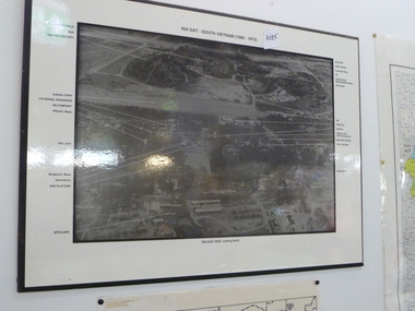 National Vietnam Veterans Museum (NVVM)
Photograph, Aerial photo of Nui Dat Base
... Aerial photo of Nui Dat Base...Black & white aerial photo of "Nui Dat - vietnam (1966... in the borders of the photo. Aerial photo of Nui Dat Base Photograph ...Black & white aerial photo of "Nui Dat - vietnam (1966 - 1972)" oblique view looking north. Arrows point to buildings which are identified in the borders of the photo.nui dat base - buildings -
 Eltham District Historical Society Inc
Photograph (item) - Aerial Photograph, Aerial Photo: Shire of Eltham War Memorial, Kangaroo Ground, Jan 1951
... Aerial Photo: Shire of Eltham War Memorial, Kangaroo Ground...1951 Aerial photo 1423-110 Run 10 showing the Shire... melbourne Aerial Photograph Photograph Aerial Photo: Shire of Eltham ...1951 Aerial photo 1423-110 Run 10 showing the Shire of Eltham War Memorial at centre of image with the newly constructed Caretaker's cottage.aerial photographs, garden hill farm, kangaroo ground, memorial park, shire of eltham war memorial -
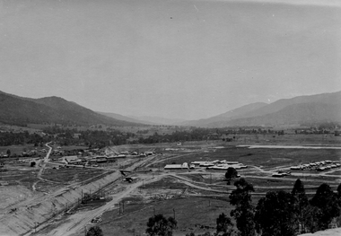 Kiewa Valley Historical Society
Photo - Aerial photo of Mt Beauty
... Photo - Aerial photo of Mt Beauty...Small sepia aerial photo of Mt Beauty taken from Big Hill...Small sepia aerial photo of Mt Beauty taken from Big Hill ...Small sepia aerial photo of Mt Beauty taken from Big Hill -
Port Melbourne Historical & Preservation Society
Plan - Map and aerial photo of Port Melbourne, c. 1990
... Map and aerial photo of Port Melbourne...Map and Aerial photo of Port Melbourne with handwritten... Street) Port Melbourne melbourne Map and aerial photo of Port ...Notations made as a result of conversations Anne had in the early 1990s with an elderly male resident of Port Melbourne.Map and Aerial photo of Port Melbourne with handwritten annotations detailing the location of various buildings, trotting tracks, etc which previously existed in Port Melbourne (recollections only).fishermans bend -
Stawell Historical Society Inc
Photograph, Aerial Photo of Stawell 1981, 1981
... Aerial Photo of Stawell 1981... grampians Photograph Aerial Photo of Stawell 1981 Very Large Colour ...Shows Railway Institute fire 1981. Swimming Pool in Cato Lake. Sawmill, King StreetVery Large Colour Print -
Stawell Historical Society Inc
Pamphlet, Aerial photo of North Western Woollen Mills
... Aerial photo of North Western Woollen Mills... grampians Pamphlet Aerial photo of North Western Woollen Mills ...Framed Hand Coloured Aerial Shot of North Western Woollen Mills c1930 showing Pleasant Creek Hospital and Surgeons Residence in Background. Also Visible is train line and wood heap.industry, health, manufacturing -
Stawell Historical Society Inc
Map, Western Mining Corp / Stawell Joint Venture, Aerial Photo of Wonga Open Cut and Tailings Dam No 2 proposed extension, January 1991
... Aerial Photo of Wonga Open Cut and Tailings Dam No 2... grampians Map Aerial Photo of Wonga Open Cut and Tailings Dam No 2 ...Shows proposed extension No2 Tailings Dam off Lavett Road and proposed Revegetation Corridors Western Mining Corporation Limited Stawell Joint Venturemining, gold, map -
 Eltham District Historical Society Inc
Slide - Photograph, Aerial Photo (c.1987): Main Road, Fitzsimons Lane, Lower Plenty, c.Aug. 1990
... Aerial Photo (c.1987): Main Road, Fitzsimons Lane, Lower... melbourne Photograph Slide Aerial Photo (c.1987): Main Road ...Part of a presentation, "Roads and Byways of the Shire of Eltham", by Russell Yeoman to the 12 September 1990 Society meeting. Slides shown included copies of old photos and recent images ranging from the suburban streets of Eltham and Montmorency to the mountain roads of Kinglake. In the byways category are views of some iof the Shire's bicycle paths including then recently completed sections of the Main Yarra Trail at Lower Plenty.35mm colour positive transparency (1 of 37) Mount - Agfachrome Agfa CS System black 8 dotsinfrastructure, roads, aerial photographs, roundabout, bolton steet, bolton steet shops, eltham, fitzsimons lane, lower plenty, main road -
 Eltham District Historical Society Inc
Slide - Photograph, Aerial Photo (c.1987): Montmorency South Primary School, Grand Boulevard and Main Road, c.Aug. 1990
... Aerial Photo (c.1987): Montmorency South Primary School... melbourne Photograph Slide Aerial Photo (c.1987): Montmorency South ...Part of a presentation, "Roads and Byways of the Shire of Eltham", by Russell Yeoman to the 12 September 1990 Society meeting. Slides shown included copies of old photos and recent images ranging from the suburban streets of Eltham and Montmorency to the mountain roads of Kinglake. In the byways category are views of some iof the Shire's bicycle paths including then recently completed sections of the Main Yarra Trail at Lower Plenty.35mm colour positive transparency (1 of 37) Mount - Agfachrome Agfa CS System black 8 dotsinfrastructure, roads, aerial photographs, main road, montmorency, montmorency south primary school, grand boulevard -
 Eltham District Historical Society Inc
Slide - Photograph, Aerial Photo (c.1987): Main Road, Lower Plenty from Heidelberg Golf Course to Plenty River, c.Aug. 1990
... Aerial Photo (c.1987): Main Road, Lower Plenty from... melbourne Photograph Slide Aerial Photo (c.1987): Main Road, Lower ...Part of a presentation, "Roads and Byways of the Shire of Eltham", by Russell Yeoman to the 12 September 1990 Society meeting. Slides shown included copies of old photos and recent images ranging from the suburban streets of Eltham and Montmorency to the mountain roads of Kinglake. In the byways category are views of some iof the Shire's bicycle paths including then recently completed sections of the Main Yarra Trail at Lower Plenty.35mm colour positive transparency (1 of 37) Mount - Agfachrome Agfa CS System black 8 dotsinfrastructure, roads, aerial photographs, heidelberg golf club, lower plenty, lower plenty bridge, main road, plenty river -
 Eltham District Historical Society Inc
Slide - Photograph, Aerial Photo (c.1987): Sherbourne Road overpass, Briar Hill, c.Aug. 1990
... Aerial Photo (c.1987): Sherbourne Road overpass, Briar Hill... melbourne Photograph Slide Aerial Photo (c.1987): Sherbourne Road ...Part of a presentation, "Roads and Byways of the Shire of Eltham", by Russell Yeoman to the 12 September 1990 Society meeting. Slides shown included copies of old photos and recent images ranging from the suburban streets of Eltham and Montmorency to the mountain roads of Kinglake. In the byways category are views of some iof the Shire's bicycle paths including then recently completed sections of the Main Yarra Trail at Lower Plenty.35mm colour positive transparency (1 of 37) Mount - Agfachrome Agfa CS System black 8 dotsinfrastructure, roads, aerial photographs, briar hill, overpass, para road, railway bridge, sherbourne road -
 Eltham District Historical Society Inc
Slide - Photograph, Aerial Photo (c.1987): Were Street, Montmorency, c.Aug. 1990
... Aerial Photo (c.1987): Were Street, Montmorency... melbourne Photograph Slide Aerial Photo (c.1987): Were Street ...Part of a presentation, "Roads and Byways of the Shire of Eltham", by Russell Yeoman to the 12 September 1990 Society meeting. Slides shown included copies of old photos and recent images ranging from the suburban streets of Eltham and Montmorency to the mountain roads of Kinglake. In the byways category are views of some iof the Shire's bicycle paths including then recently completed sections of the Main Yarra Trail at Lower Plenty.35mm colour positive transparency (1 of 37) Mount - Agfachrome Agfa CS System black 8 dotsinfrastructure, roads, aerial photographs, montmorency, were street -
 Eltham District Historical Society Inc
Slide - Photograph, Aerial Photo (c.1987): Montmorency, north of railway, c.Aug. 1990
... Aerial Photo (c.1987): Montmorency, north of railway... melbourne Photograph Slide Aerial Photo (c.1987): Montmorency, north ...Part of a presentation, "Roads and Byways of the Shire of Eltham", by Russell Yeoman to the 12 September 1990 Society meeting. Slides shown included copies of old photos and recent images ranging from the suburban streets of Eltham and Montmorency to the mountain roads of Kinglake. In the byways category are views of some iof the Shire's bicycle paths including then recently completed sections of the Main Yarra Trail at Lower Plenty.35mm colour positive transparency (1 of 37) Mount - Agfachrome Agfa CS System black 8 dotsinfrastructure, roads, aerial photographs, montmorency -
 Eltham District Historical Society Inc
Slide - Photograph, Aerial Photo (c.1987): Main Road, Eltham from Pitt Street to Elsa Court, c.Aug. 1990
... Aerial Photo (c.1987): Main Road, Eltham from Pitt Street... melbourne Photograph Slide Aerial Photo (c.1987): Main Road, Eltham ...Part of a presentation, "Roads and Byways of the Shire of Eltham", by Russell Yeoman to the 12 September 1990 Society meeting. Slides shown included copies of old photos and recent images ranging from the suburban streets of Eltham and Montmorency to the mountain roads of Kinglake. In the byways category are views of some iof the Shire's bicycle paths including then recently completed sections of the Main Yarra Trail at Lower Plenty.35mm colour positive transparency (1 of 37) Mount - Agfachrome Agfa CS System black 8 dotsinfrastructure, roads, aerial photographs, alistair knox park, bridge street, central park, diamond street, elsa court, eltham, eltham common, eltham railway station, eltham town park, main road, pitt street -
 Eltham District Historical Society Inc
Slide - Photograph, Aerial Photo (c.1987): Woodridge Estate, Eltham, c.Aug. 1990
... Aerial Photo (c.1987): Woodridge Estate, Eltham... melbourne Photograph Slide Aerial Photo (c.1987): Woodridge Estate ...Part of a presentation, "Roads and Byways of the Shire of Eltham", by Russell Yeoman to the 12 September 1990 Society meeting. Slides shown included copies of old photos and recent images ranging from the suburban streets of Eltham and Montmorency to the mountain roads of Kinglake. In the byways category are views of some iof the Shire's bicycle paths including then recently completed sections of the Main Yarra Trail at Lower Plenty.35mm colour positive transparency (1 of 37) Mount - Agfachrome Agfa CS System black 8 dotsinfrastructure, roads, aerial photographs, eltham, housing estate, woodridge estate -
 Eltham District Historical Society Inc
Slide - Photograph, Aerial Photo (c.1987): Main Road and Leanne Drive, Eltham, c.Aug. 1990
... Aerial Photo (c.1987): Main Road and Leanne Drive, Eltham... melbourne Photograph Slide Aerial Photo (c.1987): Main Road ...Part of a presentation, "Roads and Byways of the Shire of Eltham", by Russell Yeoman to the 12 September 1990 Society meeting. Slides shown included copies of old photos and recent images ranging from the suburban streets of Eltham and Montmorency to the mountain roads of Kinglake. In the byways category are views of some iof the Shire's bicycle paths including then recently completed sections of the Main Yarra Trail at Lower Plenty.35mm colour positive transparency (1 of 37) Mount - Agfachrome Agfa CS System black 8 dotsinfrastructure, roads, aerial photographs, eltham, leanne drive, main road -
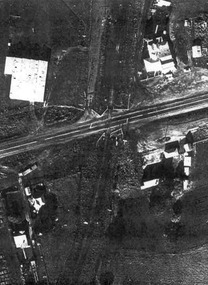 Ballarat Tramway Museum
Document - Photocopies, John Phillips, Bungaree Aerial photo, 1980's
... Bungaree Aerial photo... Aerial photo Two sets of three copies of the Victorian Railways ...Demonstrates the use of bogie trams on the Lydiard St North route and the crossing of trams at Seymour St loop.Two sets of three copies of the Victorian Railways aerial photographs of Bungaree Railway station late 1960's early 1970's. Shows tennis court, station buildings, houses and sheds in the station yard. The level crossing does not appear to have any flashing lights installed on it.trams, tramways, bungaree, aerial views, victorian railways -
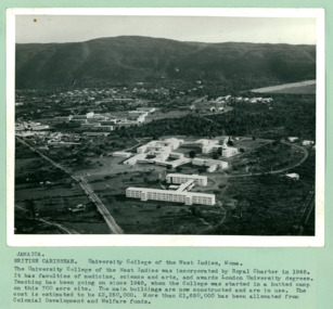 Department of Health and Human Services
An aerial photo of University College, on a 700 acre site, in the West Indies at Mona Jamaica - Department of Health – National Fitness Office (Sports & Recreation) – Press Release Photo - Empire Youth Day & Royal Tours
... An aerial photo of University College, on a 700 acre site... Melbourne melbourne An aerial photo of University College, on a 700 ...Department of Health – National Fitness Office (Sports & Recreation) – Historical Press Release Photo - Empire Youth Day & Royals on Tour CollectionDepartment of Health – National Fitness Office (Sports & Recreation) – Historical Press Release Photo - Empire Youth Day & Royals on Tour Collection -
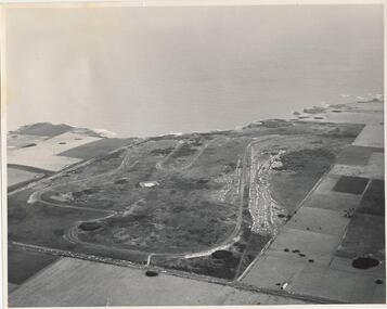 Phillip Island and District Historical Society Inc.
Photograph, J D Payens, Aerial photo of Grand prix track and painting of 1932 Grand Prix
... Aerial photo of Grand prix track and painting of 1932 Grand...Photograph Photograph Aerial photo of Grand prix track ...The Circuit was built in the 1950's and opened in 1956. The circuit was closed in 1962 due to lack of finance for repair work to the track. In 1964 Len Lukey purchased the cirtuit and reopened in 1967, but once again was closed in 1978 as not suitable for modern racing. It was used only for Historic Rallies and the like until 1982. In 1985 The Circuit was purchsed by Placetac Pty Ltd. The Circuit was refurbished in 1988. In 1989 The Australian Motorcycle Grand Prix - 1st World Championship Round - was held at the Circuit on 9th April. 2004 the Circuit and surrounding land was purchased by The Linfox Group who still own it to this day (8/10/2016).Black & White aerial view of the Phillip Island Grand Prix Race Track with Bass Strait in the background and painting of 1932 Grand PrixJ. D. Payne - Commercial Photographer, Rice Street, Moorabbin. Phone: XL 3144phillip island g p circuit, grand prix circuit phillip island, len lukey, linfox group, jean parle, bill thompson, keith riordan, bugatti, 1932 grand prix -
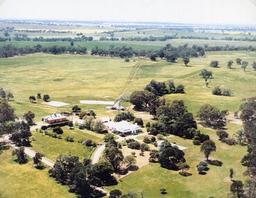 Stawell Historical Society Inc
Photograph, "Kirkella" Homestead 2001 -- Aerial Photo
... "Kirkella" Homestead 2001 -- Aerial Photo...Photograph "Kirkella" Homestead 2001 -- Aerial Photo Aerial ...Aerial photograph of Kirkella homestead taken in 2001. Shows Cricket pitch on Right Hand Side of photo partly surrounded by trees.stawell sport -
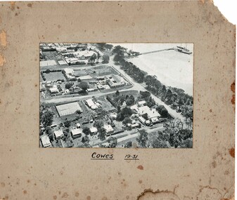 Phillip Island and District Historical Society Inc.
Photograph, Aerial photo Cowes 1931, 1931
... Aerial photo Cowes 1931...Photograph Aerial photo Cowes 1931 Black & white photo ...Cowes in the era of guesthouses with large tennis courts and open space.HistoricalBlack & white photo mounted on cardboard of Cowes jetty with boats, Thompson Ave, The Esplanade, Isle of Wight, The Continental Guesthouse, Erewhon Guesthouse, Yackatoon Guesthouse.Cowes 1931cowes, aerial photos, jetty, isle of wight, continental, yackatoon, guesthouses, bass avenue