Showing 696 items matching aerial view
-
 Stawell Historical Society Inc
Photograph - 1919 Aerial View Over Stawell, Main Street Area Looking toward Big Hill 1919-- Aerial View
... 1919 Aerial View Over Stawell...Main Street Area Looking toward Big Hill 1919-- Aerial View...Aerial View – Main Street Area 1919 Looking toward Big Hill...Aerial View over Stawell taken by R J McClure 1919...1919 Aerial View Over Stawell Photograph Main Street Area ...Aerial View – Main Street Area 1919 Looking toward Big HillAerial View over Stawell taken by R J McClure 1919stawell -
 Glenelg Shire Council Cultural Collection
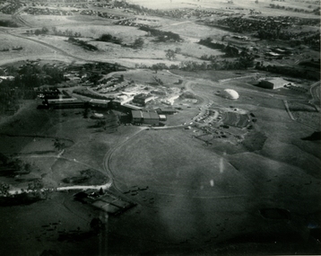
Photograph - Photograph - Aerial view of Cresco/Pivot, Aerial view of Cresco/Pivot, c. 1960
... Photograph - Aerial view of Cresco/Pivot...Aerial view of Cresco/Pivot...Black and white photograph of an aerial view of a factory.... Cliff Street Portland great-ocean-road Photograph - Aerial view ...Port of Portland Authority archivesFront: (no inscriptions) Back: (no inscriptions)port of portland -
 NMIT (Northern Melbourne Institute of TAFE)
Photographs: PTS Admin Building c1940s aerial view, Photographs: Preston Technical School Administration Building c1940s aerial view
... Photographs: PTS Admin Building c1940s aerial view... Building c1940s aerial view...Two black and white photographs of aerial view of Building...: PTS Admin Building c1940s aerial view Photographs: Preston ...Two black and white photographs of aerial view of Building A (Administration Building) Preston campus of Preston Technical School c1940s. preston technical school, buildings, nmit -
 Camberwell Historical Society
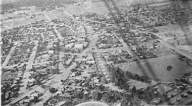
Photograph, Camberwell Victoria, aerial view of the District, c. 1940
... Camberwell Victoria, aerial view of the District..., aerial view of the District, c. 1940' ...Camberwell Victoria, aerial view of the District, c. 1940...Photograph Photograph Camberwell Victoria, aerial view ...Print of photograph with inscription 'Camberwell Victoria, aerial view of the District, c. 1940' Camberwell Victoria, aerial view of the District, c. 1940camberwell -
 Glenelg Shire Council Cultural Collection
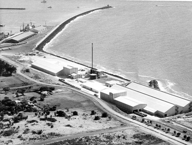
Photograph - Photograph - aerial view of Portland harbour, 1960
... Photograph - aerial view of Portland harbour...Black and white aerial view of harbour....Front: Harbour: Aerial view south. July '60 - typed, bottom.... Cliff Street Portland great-ocean-road Photograph - aerial view ...Port of Portland AuthorityFront: Harbour: Aerial view south. July '60 - typed, bottom.port of portland archives, aerial photography, portland harbour -
University of Melbourne, Burnley Campus Archives
Photograph - Black and white print, Aerial View of Burnley Campus, 1972
... Aerial View of Burnley Campus...aerial view...Aerial View of Burnley Campus, Enlargement of B92.553C... View of Burnley Campus Aerial View of Burnley Campus ...Aerial View of Burnley Campus, Enlargement of B92.553C. View of Burnley Campus.Inscribed on reverse, "30.1.72 2602/62."burnley campus, aerial view -
University of Melbourne, Burnley Campus Archives
Photograph - Black and white print, Aerial View of Burnley Campus c. 1960, c. 1960
... Aerial View of Burnley Campus c. 1960...aerial view...Aerial View of Burnley Campus.Enlargement showing layout... View of Burnley Campus c. 1960 Aerial View of Burnley ...Aerial View of Burnley Campus.Enlargement showing layout of Burnley Campus. Same as B91.296burnley campus, aerial view -
 University of Melbourne, Burnley Campus Archives
Photograph - Black and white prints, Aerial View of Burnley Campus, 1963-1970
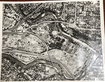
... Aerial View of Burnley Campus...aerial view...Aerial View of Burnley Campus. (B) Original... Aerial View of Burnley Campus Aerial View of Burnley Campus. (B ...Freeway was not begun until 1968.Aerial View of Burnley Campus. (B) Original of (A). Enlargement (C) Laminated copy(A) Inscribed on reverse, "South Eastern Freeway 9.7.63 R22.024.439." (C) Paper attachment: The Burnley College Portion of Richmond Park in 1972. Swan Street Takes Its Familiar Route. The Boulevard Has Been Constructed. The Golf Course is in Place. The Series of Parallel Buildings Along the Railway Line at the Bottom of the Photo Are the Poultry Sheds Used For Egg-Laying Competitions. Burnley Sidings Were Still to be Built. In the Mid-1990's Much of the Western Portion of the College Grounds/Richmond Park Was Sold.burnley campus, aerial view, south eastern freeway -
Glenelg Shire Council Cultural Collection
Photograph - Photograph - aerial view of Portland, 1960
... Photograph - aerial view of Portland...Black & white aerial view of Portland Harbour, looking...Back: Aerial View South - July '60 -Top left, pencil... Cliff Street Portland great-ocean-road Photograph - aerial view ...Port of Portland Authority ArchivesBack: Aerial View South - July '60 -Top left, pencilport of portland archives, aerial photography, portland harbour -
 University of Melbourne, Burnley Campus Archives
Photograph - Black and white print, Aerial View of Burnley Campus C.1965, c. 1965
... Aerial View of Burnley Campus C.1965...aerial view...Enlarged photograph of aerial view of Burnley College... View of Burnley Campus C.1965 Enlarged photograph of aerial ...Enlarged photograph of aerial view of Burnley College encompassed by the Yarra River and showing the surrounding suburban areas. Mounted on cardboard.aerial view, burnley college, yarra river -
 Ballarat Base Hospital Trained Nurses League
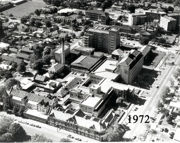
Aerial View of Ballarat Base Hospital, 1972
... Aerial View of Ballarat Base Hospital, 1972...aerial view...Aerial View of Ballarat Base Hospital, 1972... Street Nth Ballarat goldfields Aerial View of Ballarat Base ...Aerial View of Ballarat Base Hospital, 1972Shows all hospital buildings including the Nurses HomePhoto - black & whitenurses, home, 1972, aerial view, ballarat, hospital -
 City of Ballarat Libraries
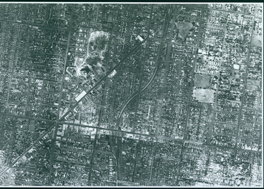
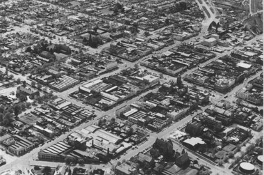
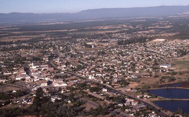
Photograph, Aerial View of the Ballarat CBD in 1957 / 1958
... Aerial View of the Ballarat CBD in 1957 / 1958....Aerial view...This aerial view of the Ballarat CBC was taken sometime... Ballarat East goldfields Photograph Photograph Aerial View ...This aerial view of the Ballarat CBC was taken sometime in 1957 or 1958. Sturt Street can be seen running from the right centre to top left.aerial view, sturt street, ballarat, central business district, cbd -
 University of Melbourne, Burnley Campus Archives
Photograph - Black and white print, Aerial View of Burnley Campus C.1970, c. 1970
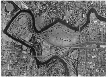
... Aerial View of Burnley Campus C.1970...aerial view...Aerial View of Burnley Campus. Enlargement. Shows position... View of Burnley Campus C.1970 Aerial View of Burnley Campus ...Aerial View of Burnley Campus. Enlargement. Shows position of Campus in bend of Yarra River after alterations to the position of the river due to building of Freeway, new ovals and Richmond Public Golf Course.burnley campus, aerial view, yarra river, richmond public golf course -
 University of Melbourne, Burnley Campus Archives
Photograph - Black and white print, Aerial View of Burnley Campus c. 1930, c. 1930
... Aerial View of Burnley Campus c. 1930...aerial view...Aerial View of Burnley Campus. Enlargements. (A) Heyington... View of Burnley Campus c. 1930 Aerial View of Burnley Campus ...Aerial View of Burnley Campus. Enlargements. (A) Heyington Bridge to South, Yarra River on North side. (B) Heyington Bridge at top of photograph i.e. reverse view of (A). (C ) Original of (B)mounted on board probably taken at the time of the floods of 30 November 1934. heyington bridge, yarra river, aerial view, burnley campus, 1934 flood -
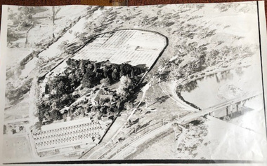
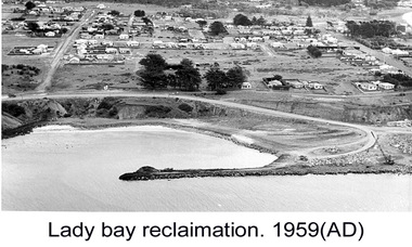 Glenelg Shire Council Cultural Collection
Photograph - Photograph - Lady Bay Reclamation: Aerial view looking West showing dumping of quarry overburden, 1959
... Photograph - Lady Bay Reclamation: Aerial view looking West... breakwater. Houses in background. Lady Bay Reclamation: Aerial view.../ Aerial view looking West showing dumping of/ Quarry overburden... Reclamation: Aerial view looking West showing dumping of quarry ...Port of Portland Authority archivesFront: (no inscriptions) Back: 1959/ Lady Bay Reclamation/ Aerial view looking West showing dumping of/ Quarry overburden (black pen, upper left)port of portland archives, lady bay, reclamation, 1960s -
Stawell Historical Society Inc
Map, Crocodile Gold Corp, Photographic Aerial View of Big Hill showing underground workings and surface workings and proposed Big Hill Open Pit proposal, December 2014
... Photographic Aerial View of Big Hill showing underground...Aerial Views Stawell... grampians Map Photographic Aerial View of Big Hill showing ...Crocodile Gold Corp SGM photo Map showing Magdala Decline& Wonga Decline December 2014 Produced for Public Consultation over Big Hill Open Pit Proposal. Aerial Views Stawellmining, gold, map -
 Ringwood and District Historical Society
Photograph, Aerial view of Park Orchards and Ringwood - c.1960
... Aerial view of Park Orchards and Ringwood - c.1960....Catalogue card reads, "Aerial view of Ringwood".... Road Ringwood North melbourne Photograph Aerial view of Park ...Catalogue card reads, "Aerial view of Ringwood". -
Glenelg Shire Council Cultural Collection
Postcard - Postcard - Portland Harbour, c. 1970
... aerial view of Portland Harbour...Coloured photo postcard, serrated edge. Aerial view...Back: Maker details. 'Portland Vic, Aerial view of Portland.... 'Portland Vic, Aerial view of Portland Harbour' postcard aerial view ...Coloured photo postcard, serrated edge. Aerial view of Portland and harbour, 1970sBack: Maker details. 'Portland Vic, Aerial view of Portland Harbour'postcard, aerial view of portland harbour -
Federation University Historical Collection
Image, Aerial View of Ballarat
... Aerial View of Ballarat...Lithograph of an aerial view of Ballarat.... Aerial View of Ballarat Lithograph of an aerial view of Ballarat ...Lithograph of an aerial view of Ballarat.ballarat, aerial -
 Federation University Historical Collection
Photograph, Aerial View of Mount Helen Campus, 1985
... Aerial View of Mount Helen Campus...Aerial views of Mount Helen Campus... Photograph Aerial View of Mount Helen Campus Aerial views of Mount ...Aerial views of Mount Helen Campusmount helen campus, aerial -
Federation University Historical Collection
Photograph, Aerial View of the Mount Helen Campus, 1983
... Aerial View of the Mount Helen Campus...Aerial view of the Mount Helen Campus... Photograph Aerial View of the Mount Helen Campus Aerial view ...Aerial view of the Mount Helen Campusmount helen campus, aerial -
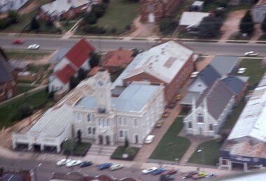 Stawell Historical Society Inc
Slide, Ian McCann, Aerial View of Town Hall
... Aerial View of Town Hall...Aerial View of Town and nearby buildings...Slide Aerial View of Town Hall Aerial View of Town ...Aerial View of Town and nearby buildingsbuildings, town hall -
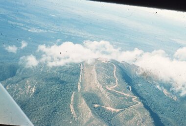 Stawell Historical Society Inc
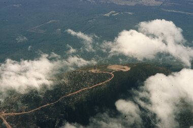
Slide, Ian McCann, Aerial View of the Grampians, 1960's
... Aerial View of the Grampians...Aerial View of the Grampians though clouds...Slide Aerial View of the Grampians Aerial View ...Aerial View of the Grampians though cloudsgrampians -
University of Melbourne, Burnley Campus Archives
Photograph - Black and white print, Aerial View of Burnley Campus, 1977
... Aerial View of Burnley Campus...aerial view... river glenferrie road east swan street aerial view ...Framed enlargements. (A) Burnley College and surrounding suburbs showing the nearly constructed Freeway, the College in the bend of the Yarra River, Glenferrie Road to the East Swan Street to the North. (B) Enlargement of (A) showing detail of Burnley College.burnley college, suburbs, freeway, yarra river, glenferrie road, east swan street, aerial view -
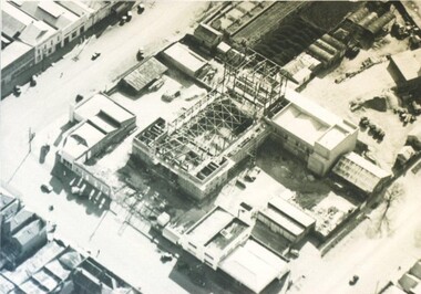 City of Ballarat Libraries
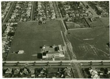
Photograph - Card Box Photographs, Aerial view of the Civic Hall under construction, Ballarat circa 1951
... Aerial view of the Civic Hall under construction, Ballarat...aerial view... as it was being constructed. civic hall ballarat mair street aerial view ...This photo shows the buildings still standing around the Civic Hall as it was being constructed.civic hall, ballarat, mair street, aerial view, armstrong street north, building, construction, public building -
 Federation University Historical Collection
Photograph, Aerial View of the Gippsland Institute of Advanced Education, 1990-91
... Aerial View of the Gippsland Institute of Advanced...Aerial View of the Gippsland Institute of Advanced... Photograph Aerial View of the Gippsland Institute of Advanced ...Aerial View of the Gippsland Institute of Advanced Educationgippsland campus collection, churchill, gippsland institute of advanced education, aerial -
 Federation University Historical Collection
Photograph, Aerial View of the Gippsland Institute of Advanced Education, c1980s
... Aerial View of the Gippsland Institute of Advanced...Aerial View of the Gippsland Institute of Advanced... Photograph Aerial View of the Gippsland Institute of Advanced ...Aerial View of the Gippsland Institute of Advanced Educationgippsland campus collection, churchill, gippsland institute of advanced education, aerial -
Federation University Historical Collection
Photograph, Ballarat School of Mines Aerial View, c1982
... Ballarat School of Mines Aerial View...Aerial view of the Ballarat School of Mines campus.... Photograph Ballarat School of Mines Aerial View Aerial view ...Aerial view of the Ballarat School of Mines campus.ballarat school of mines, aerial -
 Stawell Historical Society Inc
Slide, Ian McCann, Aerial View of Stawell
... Aerial View of Stawell...Aerial View of Stawell looking towards the Grampians...Slide Aerial View of Stawell Aerial View of Stawell looking ...Aerial View of Stawell looking towards the Grampiansstawell -
 Stawell Historical Society Inc
Slide, Ian McCann, Aerial View of Mt Willaim through Cloud, 1960's
... Aerial View of Mt Willaim through Cloud...Aerial View of Mt William through Cloud...Slide Aerial View of Mt Willaim through Cloud Aerial View ...Aerial View of Mt William through Cloudgrampians, mt william