Showing 81 items matching forest edge
-
 Mt Dandenong & District Historical Society Inc.
Photograph, View from 'Forest Edge', 1973
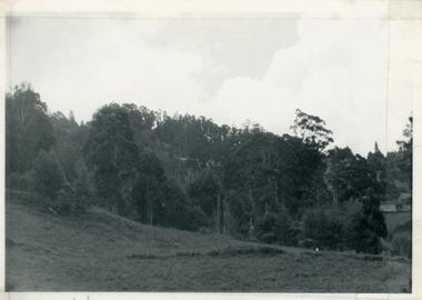
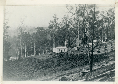
... View from 'Forest Edge'...forest edge...Photograph taken in 1973 from the property 'Forest Edge...Taken November 1973 by JLC. View looking from “Forest Edge...-and-the-dandenong-ranges Photograph View from 'Forest Edge' Photograph taken ...Photograph taken in 1973 from the property 'Forest Edge', the home of early settler George Barber. This photograph has a detailed inscription on the back handwritten by John Lundy-Clarke in 1973.Taken November 1973 by JLC. View looking from “Forest Edge” George Barber’s old home towards Price’s Lot 18. Gap on right skyline. Broadways house centre on Lot 18. Lot 25 in foreground recently cleared by Merchant Builders. Kia Ora site centre left. forest edge, george barber, price, kia ora -
 Mt Dandenong & District Historical Society Inc.
Photograph, George Barber's Home Forest Edge after 1912 Looking South West, c1912
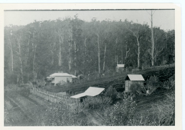
... George Barber's Home Forest Edge after 1912 Looking South...forest edge...George Barber built a homestead later named Forest Edge... Barber built a homestead later named Forest Edge on Barber's Road ...George Barber built a homestead later named Forest Edge on Barber's Road and lived there with his wife Sarah Ann (nee Richardson).Black and white photograph showing the side view of a house and three outbuildings. Reverse of photograph has handwritten description by John Lundy-Clarke.George Barber's home on bend of Barber's Road on Lot 25, Village Settlement. Showing passionfruit plantation. Buggy shed top right. Hay shed lower right. Stables, cart shed and men's quarters lower left about 1912. Photo copied by JLC in 1973.forest edge, george barber, sarah ann barber, kalorama, barber's road -
 Mt Dandenong & District Historical Society Inc.
Photograph, View of the Kalorama Valley c1905
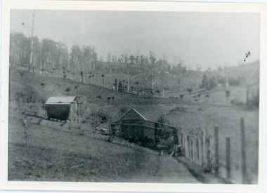
... Forest Edge... Barber's house 'Forest Edge' on Barbers Road. 'Forest Edge... house 'Forest Edge' on Barbers Road. 'Forest Edge' was built ...John Lundy-Clarke grew up in the Kalorama/Mt Dandenong area and later in life (1972-74) began to write a comprehensive history of the area working from an original settlement map in an effort to cover all areas. This photograph c1905 is looking up from George Barber's house 'Forest Edge' on Barbers Road. 'Forest Edge' was built c1898 and was the home of George Barber and his wife Sarah Ann (nee Richardson). The buildings in the foreground are the stables and hayshed.Black and white photograph showing two small buildings in the foreground with cleared hills behind. Handwritten decription on back by John Lundy-ClarkeA 1905 view of the Kalorama Valley towards the Gap. Barbers stables in foreground with hayshed on left. Tait’s house in centre of picture with Logans in the same fold above the hayshed. “Kalorama” is centre of Gap with Paynter’s “Iona” on its left with stables to its left. It was from one of these trees on the top left that the runaway log was cut that leaped over Barbers Road (at the top edge of the cleared land) then over Logan’s house in one bound in 1930.george barber, sarah ann barber, john lundy-clarke, forest edge -
 Mt Dandenong & District Historical Society Inc.
Photograph, Home of George and Sarah Barber c1905
... forest edge...George and Sarah Ann Barbers home "Forest Edge' on Barber's... 1908. George and Sarah Ann Barbers home "Forest Edge ...George and Sarah Ann Barbers home "Forest Edge' on Barber's Road. Jabez Richardson (father of Sarah Ann) and his wife Sarah jane are standing on the front verandah. An unknown male is also in the picture.Black and white photograph showing four adults standing on the front verandah of a house. Reverse of photograph has handwritten description by John Lundy-Clarke.Jabez and Sarah Jane Richardson on verandah of home of their daughter Sarah Ann (Mrs Barber) 1905. Sarah jane died 1906. Jabez died 1908.forest edge, george barber, sarah ann richardson, sarah ann barber, jabez richardson, sarah jane richardson -
 Mt Dandenong & District Historical Society Inc.
Photograph, Harry Walker's Home in Village Settlement 1908, c1908
... forest edge... on Vil. Set Lot 18 to Barber’s house now known as “Forest Edge... known as “Forest Edge” on Vil Set Lot 25 down close ...View of Harry Walker's home taken from waht is now known as Ridge Road, Kalorama. Raspberry crops are in the foreground. This photograph has a detailed inscription on the back handwritten by John Lundy-Clarke in 1974.1908 view of H Walker’s home on Village Settle Lot 2 Section 1. Looking from what is now Ridge Road through the trees on Vil. Set Lot 18 to Barber’s house now known as “Forest Edge” on Vil Set Lot 25 down close to the Olinda Creek on Barbers Road. The Estate Agent’s modern office is on the edge of the patch of raspberries at the lower left as the C.R.B. Mt Dandenong Rd passes just behind Walker’s house crossing the picture behind the raspberries.walker, raspberry crop, forest edge, barber -
 Mt Dandenong & District Historical Society Inc.
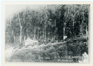
Photograph, Side View Mr G. Barber Homestead Mt Dandenong, c1905
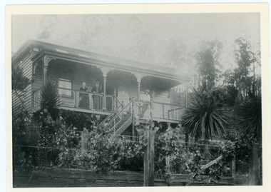
... Barber's home, later named Forest Edge. c1905. Reverse.... Later known as Forest Edge. Buggy and wagon shed on right... view of George Barber's home, later named Forest Edge. c1905 ...Built in 1898 by early settler George Barber the property is still in existence today. It was the home of George, wife Sarah Ann and daughter Ethel.Black and white photograph showing te side view of George Barber's home, later named Forest Edge. c1905. Reverse of photograph has handwritten description by John Lundy-Clarke.Barber's home on Olinda Creek. Lot 25 Sect 1 Village Settlement. Home of George Barber and wife Sarah Ann (nee Richardson). Daughter Ethel.Was bought by Munnerley later Sangster and Kinnear. Later known as Forest Edge. Buggy and wagon shed on right. Photo copied 1973 by JLC. -
 8th/13th Victorian Mounted Rifles Regimental Collection
Photograph, 1917
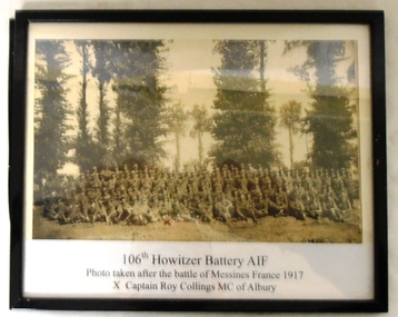
... of soldiers posed on forest edge. they are the 106th Howitzer Battery... of large group of soldiers posed on forest edge. they are the 106th ...Framed black and white photograph of large group of soldiers posed on forest edge. they are the 106th Howitzer Battery in France 1917. Battery Commander Captain Roy Collings of Albury is in front rank centre. "106th Howitzer Battery AIF / Photo taken after the battle of Messines France 1917 / Captain Roy Collings MC of Albury" ; Also notes on reverse of framing. -
 Mt Dandenong & District Historical Society Inc.
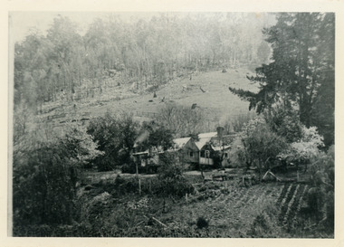
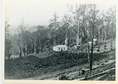
Photograph, Home Of Francis Matthew Child, c1910
... the forest edge of Harry Child miners lease on which he had his mill... Allotment “E” taken from the forest edge of Harry Child miners lease ...The homestead of Francis Matthew Child taken from the forest area downstream of Child Bros. Sawmill.Black and white photograph showing the homestead of Francis Matthew Child.This photograph has a detailed inscription on the back handwritten by John Lundy-Clarke.Francis Matthews home on Crown Allotment “E” taken from the forest edge of Harry Child miners lease on which he had his mill. Mill was upstream to the left. The trees in the background were on Hand’s selection “F” and beyond them was the summit of Mt Kalorama.homestead, francis matthew child, sawmill, child's sawmill -
 Ringwood and District Historical Society
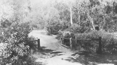
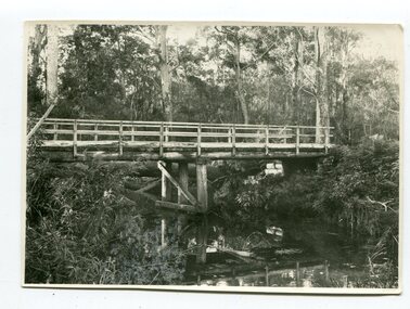
Photograph, Deep Creek bridge and road c.1935
... narrow bridge with wooded balustrades. Forested area at edge... showing narrow bridge with wooded balustrades. Forested area ...Black and white photograph of narrow unmade road showing narrow bridge with wooded balustrades. Forested area at edge of roadway.Typed below photograph, "Deep Creek bridge and road. c.1935". -
 The Beechworth Burke Museum
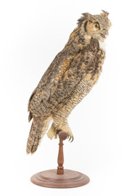
Animal specimen - Long-Eared Owl, Trustees of the Australian Museum, 1860- 1880
... , forest edges, semi-open taiga forest, swampy areas and bogs... edges, semi-open taiga forest, swampy areas and bogs, orchards ...The Long-eared owl is one of the most widely distributed and most numerous owl species in the world. It is a rather slim and long-winged bird with usually prominent erectile ear tufts, which are positioned closer to the center of the head than in many other types of owl. Long-eared owls prefer open landscapes with groups of trees, hedges or small woods, as well as pastureland with rows of trees and bushes, any type of forest with clearings, forest edges, semi-open taiga forest, swampy areas and bogs, orchards with old fruit trees, parks, even gardens and timbered areas in villages, towns or cities. In many parts of the world, Long-eared owls have even adapted to deserts, though more commonly semi-desert, and may nest and roost in available oases and hunt prey over the open desert ground. This particular specimen has been mounted in a correctly stylised fashion. This specimen is part of a collection of almost 200 animal specimens that were originally acquired as skins from various institutions across Australia, including the Australian Museum in Sydney and the National Museum of Victoria (known as Museums Victoria since 1983), as well as individuals such as amateur anthropologist Reynell Eveleigh Johns between 1860-1880. These skins were then mounted by members of the Burke Museum Committee and put-on display in the formal space of the Museum’s original exhibition hall where they continue to be on display. This display of taxidermy mounts initially served to instruct visitors to the Burke Museum of the natural world around them, today it serves as an insight into the collecting habits of the 19th century.This specimen is part of a significant and rare taxidermy mount collection in the Burke Museum. This collection is scientifically and culturally important for reminding us of how science continues to shape our understanding of the modern world. They demonstrate a capacity to hold evidence of how Australia’s fauna history existed in the past and are potentially important for future environmental research. This collection continues to be on display in the Museum and has become a key part to interpreting the collecting habits of the 19th century.This Long-Eared Owl is a rather slim, long-winged bird with prominent erectile ear tufts. The coloration of this Long-eared Owl is a hue of ochraceous-tawny with a brownish wash. The wings, back and chest are patterned and the facial disc is visibly well developed and light brown in colour. The ear tufts are dusky in front and darter tawny on the back. This Long-eared owl possesses a light-coloured bill and its eyes are yellowish-orange. The specimen stands upon a wooden platform. Swing tag: 33 / Virginian / Bee-boo Owl / Catalogue, page 52 / Other tag: No 19 / STRIX Virginian / N. America / taxidermy mount, taxidermy, animalia, burke museum, beechworth, australian museum, skin, reynell eveleigh johns, bird, owl, long-eared owl -
 Mt Dandenong & District Historical Society Inc.
Photograph, Walker's LOT 2
... in the vista among the tall trees beyond the raspberry patch is “Forest... the raspberry patch is “Forest Edge” which was George Barber’s home when ...Lot 2 was bought by Harry Walker in the early 1900s. Harry was married to Eva Hand, one of the six daughters of Thomas and Eliza Hand. Harry cleared the land and planted half with raspberries that remained productive until c1928. Harry's son William took over the property. The land was cut in half when the new CRB road went through in the early 1920s. John Lundy-Clarke grew up in the Kalorama/Mt Dandenong area and later in life (1972-74) began to write a comprehensive history of the area working from an original settlement map in an effort to cover all areas.Black and white photograph showing a single storey white house in the centre surrounded by crops. Handwritten description on reverse by John Lundy-Clarke.VIEW 1908 OVER LOT 2 SECTION 1 VILLAGE SETTLEMENT. TAKEN FROM RIDGE ROAD THEN MAIN ROAD FROM HALFWAY BETWEEN MOUNTJOY AND FALLS RD. CRB MAIN RD RUNS BEHIND WALKER’S HOUSE. The house seen in the vista among the tall trees beyond the raspberry patch is “Forest Edge” which was George Barber’s home when the picture was taken. The tall trees to the right of the vista were on Price’s LOT 18 and it was while cutting up one of these for firewood that a length of log weighing about ½ a ton got away downhill and leaped in one bounce over Barbers Road and Logan’s house – 1931.harry walker, william walker, eva hand, crb road, raspberries, kalorama -
 Ballarat Tramway Museum
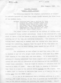
Document - Instruction, State Electricity Commission of Victoria (SECV), "Forest City Signals", 20/01/1965 12:00:00 AM
... locations along the top edge, titled Forest City Signals, and dated... in two locations along the top edge, titled Forest City Signals ...Significant in being a detailed set of instructions for the Forest City signalling system that was operated by the tram's trolley pole. Details of the locations and crossing loops where used, primarily around the loop and through Bridge St. and how it operated. Prepared and printed by the SEC during 1965.Five page, foolscap duplicated document, stapled in two locations along the top edge, titled Forest City Signals, and dated 20-1-1965, giving details about the Forest City signalling system installed in Ballarat. Explains how the system operates, gives instructions, details of the system, location of the loops, trams following each other, power failure. Also gives details of how the Bridge St system operated and the switch at Grenville St. Gives instructions for running out of the depot. Note: The locations of the signals are not as detailed as in the Driver Training Manual - See Reg Item 3486 See also Reg Item 5373 for another similar copy and fully scanned copy.trams, tramways, signals, crossing loop, forest city signals, grenville st, wendouree parade -
 Ballan Shire Historical Society
Map - Map. Bungal, Department of Lands and Survey, Bungal, County of Grant, 09/09/1926
A map of Bungal in the 1920's showing the allotments, and the size, with the names of the residents. It shows the roads and the Western and Eastern Moorarbool River, and the Whipstick State Forest.Cream coloured map of Bungal in the County of Grant, bounded by the the East Moorarbool River on the East, and the State Forest on the South. It is marked with the scale of chains and the number L.358. Lithographed at the Department of Lands and Survey. Melbourne by W. J. Butson on 9.9.1926. It shows the land allotments with names of owners.Coloured pen marks and circled numbers on various areas. Price 2 shillings marked on bottom right hand edge.bungal, kerrit bareet, egerton, lal lal, borhoneyghurk, bungeeltap, ballark, yaloak, gorong, moorarbool west -
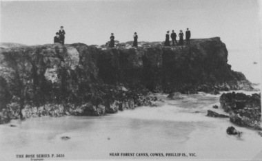 Phillip Island and District Historical Society Inc.
Photograph, Near Forrest Caves, Phillip Island
Part of a collection of 'Rose & Valentine' series of Post Cards. Copied by John Jansson 1984Black & White Postcard. View of rocks near Forrest Caves. Group of people on edge of the rock formation watching the waves.The Rose Series P3435. Near Forest Caves, Cowes, Phillip Island, Victorialocal history, photography, photographs, postcards, phillip island, black & white postcard copy, rock formation, forrest caves, phillip island -
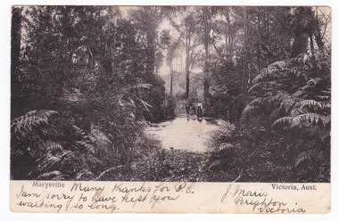 Marysville & District Historical Society
Postcard (item) - Black and white postcard, Nicholas John Caire, Marysville Victoria, Aust, 1858-1918
One of a series of postcards of photographs taken by socialite photographer Nicholas John Caire. N.J. Caire had a great love for the area and in the late 1800's took many photographs of Marysville and its surrounds.One of a series of postcards of photographs taken by socialite photographer Nicholas John Caire. N.J. Caire had a great love for the area in and surrounding Marysville and in the late 1800's took many photographs of Marysville and its surrounds. N.J. Caire was born in 1837 in Guernsey. He arrived in Adelaide about 1860 along with his parents who encouraged his early interest in photography. He opened a studio in Adelaide in 1867 after traveling extensively throughout the Gippsland taking photographs. After marrying in 1870 he moved to Talbot in Victoria until 1876 when he opened a studio in the Royal Arcade in Melbourne. After 1885 N.J. Caire gave up his city work and made his home in South Yarra and devoted the rest of his life to outdoor photography, specializing in the bush, the gullies and the mountains of south-eastern Victoria. Many thanks for P.C./ I am sorry to have kept you/ waiting so long. J. Morris/ Brighton/ Victoria POST CARD [THIS SPACE MAY BE USED FOR COMMUNICATION] ]FOR WRITING ADD (rest has been removed when stamp was removed) Mr Herman Frock/ Petersgaard/ Langebak Street/ Denmark Date Stamp/ MELBOURNE/ FEB 2?/ 4.33/ 1906 Date Stamp/ MASNEDSUND/ KALLEHAVE/ 24.3.06.1.4 Stamp/ BILL HOPKINS COLLECTION/ 21 KENSINGTON PARK ROAD W11/ NOTTING HILL GATE LONDON marysville, victoria, nicholas john caire, bill hopkins collection, postcard, souvenir -
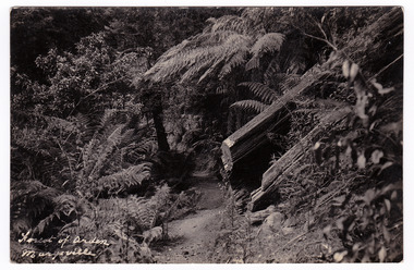 Marysville & District Historical Society
Postcard (item) - Black and white postcard, Forest of Arden Marysville, Unknown
Postcard of early photograph of the Forest of Arden near Marysville.Postcard of early photograph of the Forest of Arden near Marysville.POST CARD PLACE/ POSTAGE/ STAMP/ HEREforest of arden, marysville, forest, tree fern, postcard, souvenir, victoria -
 Marysville & District Historical Society
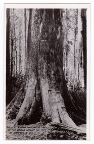
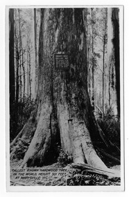
Postcard (item) - Black and white postcard, Valentine Publishing Co. Pty. Ltd, Tallest Known Hardwood Tree in the World, Height 301 Feet at Marysville, Vic. V10, 1923-1963
An early black and white photograph of the Big Tree in Cambarville in Victoria.An early black and white photograph of the Big Tree in Cambarville in Victoria. It was, at one stage, known to be the tallest hardwood tree in the world standing at 92 meters (301ft, 6 inches). However, it was reduced to 84 meters by a wind storm in 1959. It is a mountain ash. There is a walking track through the forest that will take you to the Big Tree. This postcard was published by Valentine Publishing Co. Pty. Ltd. as a souvenir of Marysville.VALENTINE'S/ POST/ CARD A GENUINE PHOTOGRAPHbig tree, mountain ash, cambarville, victoria, valentine publishing co, postcard, souvenir -
 Marysville & District Historical Society
Postcard (item) - Black and white postcard, Valentine Publishing Co. Pty. Ltd, Tallest Known Hardwood Tree in the World, Height 301 Feet at Marysville, Vic. V10, 1923-1963
An early black and white photograph of the Big Tree in Cambarville in Victoria.An early black and white photograph of the Big Tree in Cambarville in Victoria. It was, at one stage, known to be the tallest hardwood tree in the world standing at 92 meters (301ft, 6 inches). However, it was reduced to 84 meters by a wind storm in 1959. It is a mountain ash. There is a walking track through the forest to the Big Tree. This postcard was published by Valentine Publishing Co. Pty. Ltd. as a souvenir of Marysville.VALENTINE'S/ POST/ CARD A GENUINE PHOTOGRAPHbig tree, mountain ash, cambarville, victoria, valentine publishing co, postcard, souvenir -
 Marysville & District Historical Society
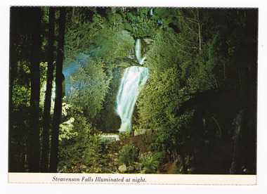
Postcard (item) - Colour postcard, Nucolorvue Productions Pty. Ltd, Steavenson Falls Illuminated at night, Pre 2009
A colour photograph of Steavenson Falls in Marysville in Victoria, illuminated at night.A colour photograph of Steavenson Falls in Marysville in Victoria, illuminated at night. The Steavenson Falls is named after the Victorian Assistant Commissioner of Roads and Bridges, John Steavenson who arrived in Victoria in the early 1860s. This postcard was produced by Nucolorvue Productions Pty. Ltd. as a souvenir of Marysville.NU-COLOR-VUE/ OF/ AUSTRALIA MARYSVILLE, VICTORIA. The Steavenson Falls illuminated at Night by its own hydro-electric/ power. (Ministry of Tourism and Forests/ Commission of Victoria) PLACE/ STAMP/ HERE POST CARD NCV.167 - NUCOLORVUE PRODUCTIONS PTY. LTD./ COPYRIGHT Printed in Australiamarysville, steavenson falls, victoria, postcard, nucolorvue productions, souvenir, john steavenson -
 Marysville & District Historical Society
Photograph (Item) - Black and white photograph, Beech Forest Beyond Tommy's Bend, c1900
An early black and white photograph of The Beeches, which is known as the Beech Grove, near Tommy's Bend near Marysville in Victoria.An early black and white photograph of The Beeches, which is known as the Beech Grove, near Tommy's Bend near Marysville in Victoria. Tommy's Bend is a stretch of road 10 kilometres from Marysville on the Wood's Point Road up to Lake Mountain. The Beeches Rainforest Walk is a loop that starts at Taggerty Cascades before winding through Myrtle Beech and Mountain Ash woodland and is one of the many walking tracks in and around Marysville. It is accessible from Lady Talbot Drive which is a 24 kilometer scenic rainforest car journey which passes a number of walks and waterfalls in the Yarra Ranges National Park. Lady Talbot Drive is named after Lady Sarah Elizabeth, the wife of Sir Reginald Talbot, who was the Governor of Victoria from 25th April, 1904 to 6th July 1908.ARMSTRONG COLLECTION 42 STATION STREET/ SANDRINGHAM 3191/ TEL. (03) 9521 5442/ IAN M.L. ARMSTRONG OAMtommy's bend, marysville, victoria, marysville-wood's point road, beech grove, wood's point road, lake mountain, beeches rainforest walk, taggerty cascades, myrtle beech, mountain ash, lady talbot drive, lady talbot forest drive, lady sarah elizabeth talbot, sir reginald talbot -
 Marysville & District Historical Society
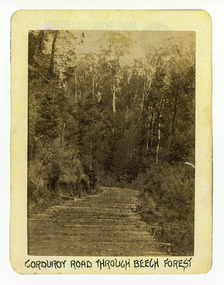
Photograph (Item) - Black and white photograph, Corduroy Road Through Beech Forest, c1900
An early black and white photograph of a corduroy road running through the forest near Marysville in Victoria.An early black and white photograph of a corduroy road running through the forest near Marysville in Victoria. A corduroy road (or log road) is a type of road or timber trackway made by placing logs, perpendicular to the direction of the road over a low or swampy area. The result is an improvement over impassable mud or dirt roads, yet rough in the best of conditions and a hazard to horses due to shifting loose logs.ARMSTRONG COLLECTION 42 STATION STREET/ SANDRINGHAM 3191/ TEL. (03) 9521 5442/ IAN M.L. ARMSTRONG OAMcorduroy road, marysville, victoria, beech forest -
 Marysville & District Historical Society
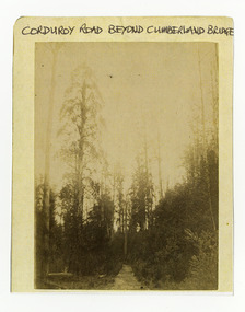
Photograph (Item) - Black and white photograph, Corduroy Road Beyond Cumberland Bridge, c1900
An early black and white photograph of a corduroy road running through the forest near Marysville in Victoria.An early black and white photograph of a corduroy road running through the forest near Marysville in Victoria. A corduroy road (or log road) is a type of road or timber trackway made by placing logs, perpendicular to the direction of the road over a low or swampy area. The result is an improvement over impassable mud or dirt roads, yet rough in the best of conditions and a hazard to horses due to shifting loose logs.ARMSTRONG COLLECTION 42 STATION STREET/ SANDRINGHAM 3191/ TEL. (03) 9521 5442/ IAN M.L. ARMSTRONG OAMcorduroy road, marysville, victoria -
 Marysville & District Historical Society
Photograph (Item) - Black and white photograph, Way to Cumberland Falls, c1900
An early black and white photograph of the forest near the Cumberland Falls in Victoria.An early black and white photograph of the forest near the Cumberland Falls in Victoria. The falls are located on the Marysville-Wood's Point Road. Cambarville is notable for its giant mountain ash (Eucalyptus regnans) trees within the Cumberland Memorial Scenic Reserve, and relics from former sawmills and gold mining. The Big Culvert is located nearby on the Marysville - Woods Point Road, which was historically part of the Yarra Track. Cambarville was established as a timber mill town in the 1940s. Timber mill owners A Cameron and FJ Barton named Cambarville. They established the mill to salvage timber from trees destroyed in the 1939 bushfires. Cambarville was impacted by the 2009 Black Saturday bushfires and any remaining structures were destroyed.ARMSTRONG COLLECTION 42 STATION STREET/ SANDRINGHAM 3191/ TEL. (03) 9521 5442/ IAN M.L. ARMSTRONG OAMcumberland falls, cambarville, marysville, victoria, waterfalls, postcard, souvenir, mountain ash, mining, timber mills, big culvert, yarra track, a cameron, fj barton, black saturday bushfires, 1939 bushfires, eucalyptus regnans -
 Bendigo Military Museum
Photograph - MEMORIAL PHOTOGRAPHS, 1960's
.2) Certain it is the military cemetery in Tobruk North Africa.1) Photo , colour,framed showing "Rats of Tobruk." Memorial window" in St Johns church forest st Bendigo. Image shows a dove of Rats of Tobruk badge with the lord under frame is wood stained with gold edge. .2) Sepia colour photo showing large military cemetery.photography, photograph, religion - christian, memorials, military history -
 Kiewa Valley Historical Society
Maps - Bogong x2, Tawonga, Omeo, Dargo, Victoria and others, 1. Bogong Alpine Area; 2. Bogong 8324; 3. Tawonga Topographical; 4. Omeo 8433; 5. Dargo 8323; 6. Victoria State
1. Bogong Alpine Area (outdoor Leisure Map. survey & Mapping Victoria, Government of Victoria, Edition 2, reprinted 1991 with an image of Mt. Feathertop on the front. Information for tourist in the Alpine National Park: Bogong Area. Including: recreational activities, history, weather and vegetation and a list of walks together with locality maps and photographs. The front cover has an image of Mt Feathertop against a blue sky with yellow writing 'Bogong Alpine Area', there is a yellow triangular block on the right hand top corner with black writing 'Outdoor Leisure Map. On the bottom edge is a block of yellow with black writing 'Survey & Mapping Victoria' and a light green map of Victoria with 'VICMSP' printed in white. 2. 8324 Bogong Victoria, Edition 1, Commonwealth of Australia 1981. A topographical Map: 1:100,000 scale (1 cm to 1 KM). Map has a red cover with white writing together with a white block and black writing and a map insert. 3. Tawonga Topographical Map - Forests Commission Victoria, / revised 5/9/77, DEG No. 68-G/399. A Tawonga 803 folded map in a beige colour with the back blank. 4. Omeo 8433 Victoria, Edition 1, Department of Natural Resources. The map has a red and white cover with black writing and a simple map of Australia at the bottom. 5. 8323 Dargo, Edition 1, Commonwealth of Australia. A red and white cover with a map insert. 6. Victoria State Map, Hema Maps, 2002. Hema Maps, State Map, colourful cover with a map of Australia and four tourism photographs. Scale 1: 850,000 An inscription handwritten in blue pen "Trappers Gap to Mitta Mitta 1" to 1 mile". There are some pen markings and notations of tracks.maps, bogong, omeo, tawonga, dargo, victoria, bogong alpine area -
 Orbost & District Historical Society
black and white photograph, June 1897
This photograph was taken at what is now the Young’s Creek picnic area which is located on the site of an old sawmill, once owned and operated by L.E. & H. Williams, dating back to the early 1920’s. The mill was eventually sold, dismantled, and the machinery transferred to a sawmill at Cabbage Tree Creek. there are still some items of old sawmill debris. The old steam engine at the edge of the car park is the remains of the mill’s former power plant. This portable steam engine was constructed in Leiston, Suffolk, in England.This is a pictorial record of a popular recreational area in the Orbost district in the late 19th century.A black / white photograph of a wooden bridge over a creek in forest setting. There is a second copy.on back - handwritten "the Young's Creek Bridge June 1897"young's-creek-orbost bridge-young's-creek -
 Orbost & District Historical Society
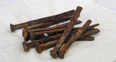
nails
These handmade nails came from the Orbost Station homestead. this was built in Forest Road around 1882. the homestead had large rooms, French windows and a verandah all the way around. As a young girl Grace Jennings Carmichael (poet) lived at the Orbost station homestead with her family.Nine long hand-made nails with square edges. The ends are blunt.nails metal -
 Warrnambool and District Historical Society Inc.
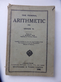
Book, The Federal Arithmetic, Early 20th century
This is a Grade V Arithmetic book used by George Bonnett at Allans Forest School. The Bonnett family farmed in the Mepunga area on the Childers Cove Road. The Allans Forest State School, number 1086, was established in 1871 and closed in 1993. The first Head Teacher was Mr Bradhurst. The school closed in 1903 and re-opened in 1905 as a half-time school with Mepunga East and in 1908 it resumed as a full time school. This book is significant because it was used by George Bonnett at the Allans Forest State School and is a memento of both the Bonnett family of Mepunga and the Allans Forest State School, a school no longer existing. It is also of antiquarian interest as an example of arithmetic school text books used early in the 20th century. This is soft cover book of 128 pages. The cover is grey with black print and black lines around the edges of the front cover. The book has a prefatory note, arithmetical exercises and advertisements for other school text books published by Whitcombe and Tombs. The cover is torn and soiled and partly ripped away. There is handwriting in black ink on the first page.‘George H. Bonnett, Allans Forest State School’bonnett family, mepunga allans forest state school history of warrnambool -
 Warrnambool and District Historical Society Inc.
Journal - Diary, Diary of Augustus Bostock 1871-1873, Circa 1871
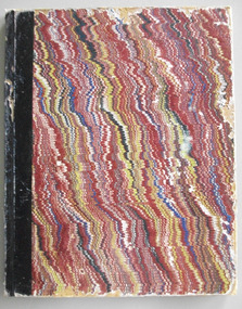
Augustus Bostock was the 9th child of Robert & Rachael Bostock of Vaucluse Epping Forest, Van Diemen’s Land. He was only 4 years old when his mother died. He was inspired by his father to seek his fortune in the Western District of Victoria. He arrived around 1850. He married Margaret Aitkin in July 1865. Augustus owned several properties in the district and leased others. He sat on the court of Warrnambool, Mortlake or Hexham as required. He resided at Marramook in Hawkesdale and later moved to Vaucluse in Hopetoun Road Warrnambool, where he died in 1918 at the age of 87. He was involved in many aspects of life in the Western District, racing, cricket, and social activities to name a few. This diary shows the daily entries over a long period of time with activities ranging from fencing, visiting neighbours and weather details. It mentions many local people and many properties he visited. Augustus Bostock along with a number of his brothers was one of the earliest pioneers in the Western District of Victoria. This diary sheds considerable light onto the life of Augustus and people of his era. There is a wealth of information on a range of topics relating to early life in Warrnambool and district.Brown, blue, yellow and white wavy pattern cover with black binding. Edges of pages have a multi coloured pattern. Entries are handwritten in black ink.G. Bostock, Coomite Jan 1st 1871 warrnambool, augustus bostock, marramook hawkesdale, bostock brothers, pioneers warrnambool -
 Warrnambool and District Historical Society Inc.
Journal - Diary, Diary of Augustus Bostock 1896-1904, Circa 1896
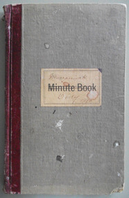
Augustus Bostock was the 9th child of Robert & Rachael Bostock of Vaucluse Epping Forest, Van Diemen’s Land. He was only 4 years old when his mother died. He was inspired by his father to seek his fortune in the Western District of Victoria. He arrived around 1850. He married Margaret Aitkin in July 1865. Augustus owned several properties in the district and leased others. He sat on the court of Warrnambool, Mortlake or Hexham as required. He resided at Marramook in Hawkesdale and later moved to Vaucluse in Hopetoun Road Warrnambool, where he died in 1920 at the age of 87. He was involved in many aspects of life in the Western District, racing, cricket, and social activities to name a few. This diary shows the daily entries over a long period of time with activities ranging from fencing, visiting neighbours and weather details. It mentions many local people and many properties he visited. Augustus Bostock along with a number of his brothers was one of the earliest pioneers in the Western District of Victoria. This diary sheds considerable light onto the life of Augustus and people of his era. There is a wealth of information on a range of topics relating to early life in Warrnambool and district.Grey cloth cover over card with maroon leather binding. Blue pages inside front and back covers. Pages are all handwritten with dates in margin. Edges of pages orange blue and yellow. Label on front cover has Minute Book printed on cream label. Marramook Diary 1896 hand written in pen. 286 pages.Marramook Sept 15th 1896 Augustus Bostock. diary of augustus bostock 1896-1904, warrnambool