Showing 100 items matching linton district
-
 Linton and District Historical Society Inc
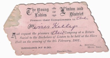
Card - Invitation, The Young Ladies of Linton and District, 1901
... The Young Ladies of Linton and District, 1901...Text: The Young / Ladies OF Linton and / District / Present...Linton and District Historical Society Inc 69 Sussex Street ...Small, pale pink polygon-shaped invitation card with decorative black printing. Name of invitees handwritten in ink. The dance would have been a way for young singles of the area to meet and socialise with members of the opposite sex.Text: The Young / Ladies OF Linton and / District / Present their Compliments to the / Misses Kellys / And request the pleasure of their Company at a Return / Social to the Bachelors of Linton to be held at the Shire / Hall on the evening of the 8th February, 1901.linton shire hall, dances, social gatherings -
 Linton and District Historical Society Inc
Ceremonial object - Baton, Linton Brass Band, 1850-1914, Linton and District Historical Society Inc
... Linton and District Historical Society Inc....Linton and District Historical Society Inc 69 Sussex Street ...Long baton with large silver knob on one end. White and gold cord with tassels at other end. Long wooden centre pole with a metal ferrule at the other end.brass bands, linton brass band, mr. m. trengrove, mr. w. todd -
 Federation University Historical Collection
Booklet, H.P. Benett, Looking back over 100 Years. 1839-1939: A Brief Historical Review on the Settlement and Development of Linton and District, 1939
... Review on the Settlement and Development of Linton and District... for the district now know as Linton.... on the Settlement and Development of Linton and District Soft cream covered ...This book was published for the centenary of white settlement at Linton. Wardy Yallock is the Aboriginal name for the district now know as Linton.Soft cream covered booklet of 42 pages. Topics include pioneers; gold; mining; civic development; municipal history, education, churches, racing, athletics, football, rifle shooting;tennis, golf;fire brigade, band, horticultural society, Linton Free Library; friendly ; societies; post office; railway; police; war; old Lintonians' Association. Images include: Ewen Rankin; Robert Rankin; John Linton; R. Ching; Mary Linton; James Nicol; J.H. Roberts; W.G. Bennett; Robert Linton; Digory Roberts; W. Campbell; W. Todd; B. Oulten; W. White; Rev. Campbell; J. Wearne; J.G.Allan; R.S. Nelson; Victory Mine; South Victoria Mine; Samuel Lewers; M.H. Baird; Thomas Younghusband; Joseph Shepherd; Thomas Kennedy; John Clarke; James Dodds; G.H. Smith; Linton State School; Sussex Street Linton Looking north; Sussex Street Linton looking South; Albert Kennedy; N. Wishartlinton, lintons diggings, wardy yallock, george sandow, mt bute station, emu hill, matthew hamilton, samuel lewers, john clarke, joseph shepherd, edward morey, james nicol, wg bennett, edwin ball, thomas bryant, william white, ewen cameron, john cameron, bryson campbell, james woodrow -
 University of Melbourne, Burnley Campus Archives
Photograph, Ministry for Planning and Environment April 1966. Photographic Archive Project, Museum of Victoria, Display of Early Victorian Gardens, 1996
... Linton district... for display purposes. 1. "Modest cottage garden, Linton District, C... purposes. 1. "Modest cottage garden, Linton District, C. 1890 ...display, early victorian gardens, garden design, linton district, geelong, stockyard hill, amherst -
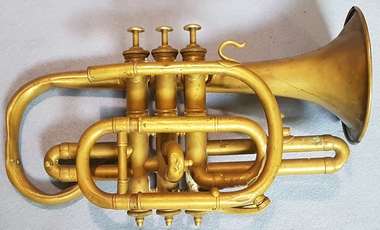 Linton and District Historical Society Inc
Instrument - Cornet, Brass, Cased, Cornet, Owned and Used by W H Nicholls, Linton Brass Band
... . The cornet was donated to Linton & District Historical Society...Linton and District Historical Society Inc 69 Sussex Street ...The cornet was owned and used by W H Nicholls, a member of the Linton Brass Band, most likely in the 1890s or early 1900s. The cornet was donated to Linton & District Historical Society in 2017 by Robyn Nicholls, of Blackburn. It is understood in the Nicholls family that Robyn's late husband, Graeme Nicholls, inherited the cornet from his great-grandfather, William Henry Nicholls (1845-1902). However it is also possible that the cornet was owned and played by Graeme's grandfather, also named William Henry Nicholls (1880-1943).Brass cornet with mouthpieces, in original dark wooden case which has red fabric lining. Instrument is approximately 30cm in length, has a 12 cm bell and three valves. A small portable sheet-music holder is also in the carrying case. The manufacturer's name "Gautrot Brevete, Paris" is imprinted on the bell, along with the inscription "Exposition Universelle de Paris, 1889, Medaille d'Or". EXHIBITION / UNIVERSELLE / DE PARIS / 1889 / MEDAILLE D'OR / Gautrot Brevete / PARIS.linton brass band, musical instruments -
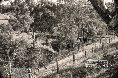
 Ballarat Heritage Services
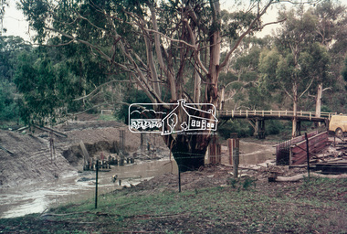
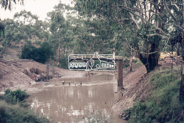
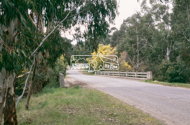
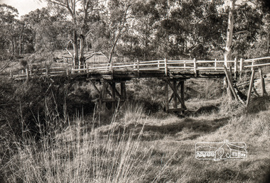
Photograph - Photograph - Colour, Clare Gervasoni, Nimon's Bridge, 1999, 04/10/1999
... community at Linton, then the Western District agricultural area... community at Linton, then the Western District agricultural area ...Nimons Bridge was built in 1890, as part of the then Ballarat-Linton railway. The bridge is 17 spans with tall timber piers of four driven piles each, with triple sets of diagonal cross-bracing and walers and a single row of longitudinal horizontal bracing between piers. The spans are of a uniform twenty feet (6.1 metres), originally supported by four 21-inch x 9-inch (535 mm x 230 mm) Kauri timber beams per span, following the standard V.R. design of the period. When the superstructure was rebuilt after the 1953 fire, the timber beams were replaced with two 24-inch (610mm) deep rolled-steel-joists on each span. These are marked 'Lancashire Steel Co., Scotland' and are believed to have been second-hand. The deck of transverse-timber planks is 103.6 metres in length. Overall the bridge has an impressive appearance with its exceptionally tall triple-cross-braced piers creating a 'three-tiered' effect, with the deck 19.2 metres above the Woady Yaloak River. The Ballarat-Skipton line closed in 1985. Nimons Bridge has been recently restored, as part of the Ballarat-Skipton Rail Trail. How is it significant? Nimons Bridge is significant for technical, historic and aesthetic reasons at a State level. Why is it significant? Nimons Bridge is technically significant as Victoria's fourth-tallest timber trestle bridge when built, and as the third-tallest surviving example. It is also the second-largest composite bridge combining traditional timber piers with RSJ spans and a timber deck and falls within a select group of fewer than ten timber railway bridges with horizontal longitudinal bracing between the piers and three sets of double cross-bracing on its tallest piers, creating a visually striking 'three tiered' effect that enhances its viaduct form. Nimons Bridge is historically significant as having served initially the mining community at Linton, then the Western District agricultural area and in later years a kaolin quarry at Pittong. Nimons Bridge is historically significant as a representative of the 'light' branch line methodology that stimulated the explosion of railway construction in Victoria during the 1880s, and provides an interesting contrast with the more solid and vastly more expensive railway viaducts built in similar terrain on Victorian main lines, at Moorabool and Taradale, in the late 1850s. Approached by a deep cutting and high embankment at either end, the bridge represents a very cost-effective late 19th century engineering solution to the characteristic physiography of western Victoria with flat basalt plains intersected by deep wide valleys occasionally subject to severe flooding. Nimons Bridge is aesthetically significant for its visually impressive viaduct form, crossing a deep and steep-sided valley that is part of a rich cultural landscape. Within close proximity of the bridge are mullock dumps, tailings, shaft sites and other relics of the deep-lead alluvial mining era. The bridge is the most visually spectacular timber-trestle rail bridge in Western Victoria and is among the most spectacular timber-trestle rail bridges surviving anywhere in Victoria. It is part of the Ballarat-Skipton Rail Trail. Classified by the National Trust :02/10/2000 (http://vhd.heritagecouncil.vic.gov.au/places/67986)Colour photograph of a log bridge known as Nimon's Bridge.ballarat-linton, nimons bridge, nimon's bridge, log bridge, viaduct, timber-trestle rail bridge -
Federation University Historical Collection
Document, Zelda Martin, Central Victorian Goldmining towns - Boom Towns or Ghost Towns?, c1996
Zelda Martin was a PhD candidate at the University of Melbourne.[.1] 4th item in light blue display book titled Research Approach/Overview of Chapters/Confirmation of Canditure/Chapters1,2,3&4 of proposed thesis. *Twenty-seven page article on Victorian goldfields towns titled: Central Victorian Goldmining Towns - Boom Towns or Ghost Towns. The article was written during the author's PhD study. It outlines the context methodology, and resources and the chapters of the proposed thesis: (1) Central Victorian Goldmining Towns - The Context (2) Contemporary Views of the Factors Necessary for Town Growth (3) Outward Manifestations of Town Growth (4) The Trappings of Government (5-9) The Main Towns and Their Hinterland. [.2] 5th item in Light Blue display book as above item. *Chapter 1 of proposed thesis titled 'Pick, Shovel and Tin Dish Mining.' Covers in Section A: Central Victoria - Pre 1851: Aborigines in Central Victoria, Squatters, and Government. Section B: The years 1851-1854: The Early Gold Rushes, Government Reaction, Township Surveys, Legislation, Town Development, Local Government and Early Settlement. [.3] 6th item in Light Blue display book as above item. *2A of proposed thesis titled 'Contemporary Views of the Factors Necessary for Town Growth'. Similar information to Chapter 1 plus extra re towns and maps. Sections: Introduction, Context of Place - Geographical Towns Listed, The Context of Time - Pre1851 Aborigines, Governance of Port Phillip, The Squatters, The Villages of Central Victorian Highlands, Conclusion, Condensed Version of Chapter2B. [.4] 7th item in Light Blue display book as above item. *Chapter2B of proposed thesis. Sections: Area of Research, Schools, Banks, Newspapers, Progress Association, Town Development - Sandhurst (Bendigo), Ballarat, Castlemaine,, Maryborough, Ararat and Stawell. [.5] 8th item in Light Blue display book as above item. *Chapter 3 of proposed thesis titled 'Outward Manifestations of Town Growth'. Sections: Introduction, Contemporary Writing, Educationalists, The Bankers, The Townsfolk, Current Theory, General Theories of Urban Development, and Conclusion. [.6] 9th item in Light Blue display book as above item. *Chapter 4 of proposed thesis titled 'Trappings of Government' Sections: Introduction, Early Government Attitudes to Mining and Town Development, Law and Order, Township Surveys, Legislation, Local Government, Transport and Communication, The People and Lobbyists. [.7] 10th item in Light Blue display book as above item. *'The Rise and Fall of Central Victorian Goldmining Towns'. Includes a map showing main Goldfields, a table showing towns and villages at two points in time - 1857 and 1871; a Bibliography of Primary and Secondary Sources. [.8] Resource No1. Black display book titled Local Towns 1 : Alma: *Brief history *Directory *Maps Amphitheatre / Mountain Hut: *Brief History Post Office Directory Ararat: *Brief History *Post Office Directory 1869 - Alphabetical Listing by Occupation *Ararat - Prominent Citizens of 1858 *Langi-Morgala Museum Avoca: *Brief History *Excerpts from 'Avoca The Early Years', Margery and Betty Beavis; pg1 - Beginnings; pg11 - The Midas Touch; pg25 - Local Gold Escorts; pg27 - A Town is Born; pg51- The Administration of Justice; pg53 - The Ways of the Law; pg61 - News of the Day; pg65 - A Time to Play; pg72 - Land Ownership *Post Office Directory (Bailliere's) 1869 *Tourism Map and Information of area *Historic Avoca - A 5.5km Tour *Avoca & the Pyrenees Region - information pamphlet Ballarat: *Early History of Ballarat - Ballarat Historical Society, Publication No.1: origin of the name; Ballaarat - the Beginning; Fabulous Yields from the Ballaarat Goldfield; *Streetscape Lydiard Street. *Hand drawn map showing Leigh River, Old Portland Bay Road, plaque on road to Colac; etc. *Newspaper article re 'The Theatre Royal' ( which stood in the vicinity of the current Owen Williams store) - 'The News'15/04/1998 *Article - 'Ballarat's Mechanics' Institute Lives On' Ballarat Courier, 14/09/1985 *Article - Standing the Test of Time' The News 17/11/1993 re The Mechanics Institute & picture of the Reading Room *'Ballarat a Study of a City, Phyllis Reichl, pub. Nelson, 1968; no.3 place, time and people field studies series *Investigator Vol.33 No.2, 1998 Geelong Historical Society. Article on pg75 describes Ballarat in 1861 *Folded poster - 'Ballarat 100' a history of telegraph communication, pub. Telecom. Beaufort (Fiery Creek): *Brief history *Post Office Directory [.9] Resource No.2 Black Folder Titled Towns cont.No2 Bendigo (Sandhurst): *'Family & Local History at the Bendigo Library - 1851-2001 150 years of gold'. *Bendigo Government Camp in 1853 illustration; key to sketch and names of Government officers stationed there *Excerpts from 'Bendigo and Vicinity' Adolph Haman *The Bendigo Goldfield Registry - pgs 1-7 Introduction *Excerpt: 'Breaking the Grip' *Excerpt: The Most Go-Ahead Place *Excerpts from 'History of Bendigo' - anti license agitation; laying out of town; proposed railway; gold calls and dividends; the Sandhurst Municipality; journalism *Bibliography Blackwood: *Excerpts from 'Aspects of Early Blackwood - The Goldfield, the Landmarks, the Pioneers' Alan J Buckingham and Margaret F Hitchcock, JG Publishing,1980 Buninyong: *A Brief History *Investigator Vol1 No.2 Feb 1966 Geelong Historical Society. Pg3 - Article re gold escort route - Mt Alexander to Adelaide - (see a simple monument on the Western Highway a few miles out of Horsham. Pg 15 - Ballarat Excursion - re the finding of gold. *Three articles published by Buninyong and District Historical Society Inc: (Magpie Exploration; Finding Gold In The Green Hills; Magpie Exploration; Burnt Bridge to Cargarie to Mt Mercer) *Copies of newspaper articles/items *Buninyong Street Directory Carisbrook: *In the Beginning There Was Carisbrook *The History of the Carisbrook Racecourse Carngham / Snake Valley: *Brief History *Directory Castlemaine: *Directory 1865-1866 - Alphabetical and Street *Poster - Castlemaine A Contemporary Guide "The Great Centre" 1866 - A Contemporary Guide to the Fascinating Past *Pamphlet - Castlemaine District Community Hospital *Map - Castlemaine, Maldon & Surrounding Districts *Map and Information - The Dry Diggings Track - a 55kl walk among historic goldfields relics ( Castlemaine Fryerstown Vaughan Mt Franklin Hepburn Daylesford) *Postcard - Former Court House *Directory 1867 - Alphabetical, Trade [.10] Resource No.3 Grey folder Titled Towns 3 Creswick to Maryborough Creswick: *Brief History *Booklet - "Creswick Cemetery Walk" *Booklet - The Buried Rivers of Gold Heritage Trail Creswick *Creswick Historical Museum Information Sheet *Chronological History of Creswick *Alphabetical Directory of the Borough of Creswick *Creswick's Creek Directory 1856 *Historic Creswick Walking Tour *A Brief Account of the Schools of Creswick - Past and Present *100 Years of Railway Travel in Creswick *The Berry Deep Leads *The Spence Home at Jackass Gully in the Creswick State Forest ( William Guthrie Spence - Pioneer) *The New Australian Mine and the 1882 Disaster *Creswick District News, Issue 7, July August 1999 *The Creswick Miners Walk - Information and Map *Maps Chewton: *Brief History *Directory Clunes: *Brief History *Clunes Street Directory Daylesford: *Brief History *Notable Bushfires in Daylesford District Over More Than a Century - "Black Thursday" 1851; 1862; 1899; the Disastrous Hepburn Fire of 1906; 1939; 1944; 1969. *Post Office Directory -Daylesford and Hepburn Dunolly / Inkerman: *Brief History *Directory *Pamphlet - Goldfields Historical Museum *Pamphlet - Historic Dunolly - Victoria's Best Kept Secret *Map of Gold Workings at Dunolly Area - showing where the main gold rushes occurred *Brief History - Inglewood *Directory - Inglewood - Name Occupation, Dwelling Kingower: *Brief History *Directory - Name / Ocupation / Dwelling Linton / Happy Valley / Piggoreet: *Brief History *Directory - Lintons McIvor: *"A History of the Shire and the Township of Heathcote" by J.O. Randell Majorca: *Brief History *Official Post Office Directory 1869 - Name / Occupation/ Address Maldon (Tarrangower): *Brief History Part 1 *Brief History Part 2 *Post Office Directory *List - Alphabetical Order by Names plus Business and Trade (Tarrangower Times Oct/1858) *List - Alphabetical Order by Trade plus Name and Business *Directory - Name / Occupation / Dwelling Maryborough: *Worsley Cottage - built by Arthur Worsley, a contractor in stonework in 1894 [.11] Resource No. 4 Blue Display Book titled Towns 4 Moliagul to Stawell Moliagul: *Brief History *Moligul Legislative Assembly (Voting?) List - Names and Occupations *Moliagul Victorian Post Office Directory 1868 - Name / Ocupation / Address / Comments *"The Welcome Stranger" gold nugget *The Sunday School *The Welcome Stranger Discovery Walk - information and map Moonambel (Mountain Creek) Redbank *Brief History *List of names extracted from advertisments of the Pioneer and Mountain Creek Advertiser 16/02/1861. *Bailliere's Directory 1869 - Alphabetical List of Name / Occupation / Place St Arnaud: *Brief History Sebastapol: *Brief History *Directory 1869 - Alphabetical by Name; plus occupation and address. Browns and Scarsdale: *Brief History *Browns Street Directory - Name and Occupation Smythesdale: *Brief Description *Smythesdale Street Directory -Name and Occupation Stawell (Pleasant Creek) *Brief History *Victorian Official Post Office Directory - Name /Occupation / Dwelling *Chronology - 1841-1920 *Production of gold statistics - 1879 - 1900 *Big Hill *Extracts from "The Golden Years of Stawell". Chapt 1 - Stawell's Coming Out. Capt. 2 - The Gold Rush. Caapt.3 - Cradle of Democracy. Chapt.4 - The Reefs Becomes Stawell. Chapt. 5 - Rushing In. Chapt.6 - The Pioneers. Chapt 7 - The Decade of Optimism. [.12] Resource No. 5: Blue Display Book titled 'Towns Steiglitz to the The Golden Triangle. Steiglitz: Brief History Victorian Post Office Directory 1869 *Map of Steiglitz *List of maps relevant to Steiglitz history *Information 6 tables of data from "Reports of Mining Surveyors Talbot (Back Creek) Brief History Taradale: Post office Directory 1869 - Name/Occupation/Street. Also list in alphabetical order by Occupation Taradale *Chronological Reference to Taradale Mines *Water - The Coliban System of Waterworks *Joseph Brady *The Syphon Tarnagulla (Sandy Creek) *Brief History *Tarnagulla Businessmen Cameos to give depth to advertisments in 'The Tarnagulla Courier' various issues 1864-1871 *Directory - Name/Occupation /Address *List - Name/Business/Trade Wedderburn (Koorong) *Brief History *List - Name/Occupation The Golden Triangle: *The Early Rushes - Wedderburn / Moliagul / Sandy Creek - Tarnagulla / Jones Creek - Waanyarra / Kingower / Dunolly - Goldsborough / Inglweood *Census of 1857 - Population / Occupations *1858-1871 - A Time of Consolidation- Wedderburn / Moliagul / Sandy Creek- Tarnagulla / Arnold *Census 1871 - Population *Information gleaned from the census data - Demographics / Population / Occupations / marital / Birthplace / Religion / Literacy/ Occupation and Housing Cameos *Graphs - Birthplace of settlers /Male-Female Ratio / Married males / Children under 15 as Percentage of Population / Religion *Census 1857 - Statistical data *Maps *Bibliography [.13] Resource No. 6 - Black Display Book Information and Research in Central Victoria including: *Banking - Research from ANZ Bank Archives *Institutions - also includes articles listed from the Ballarat Times Newspaper *Australian mining History Association - A.M.H.A. Bibliography *Australia's Mining History * Bibliography - Land Surveys Victoria - *1853 Administration (Statistics and Other) includes: schools / ministers of religion / police / military / local administration / licences for sale of spirits / distances between various Victorian gold fields. * Victoria Government Gazette (Copy) - N0. 116, 12/12/1854 includes: Gold Felds Commission of Enquiry & No. 85, 15/09/1854 - Addresses presented to the Lieutenant Governor (Sir Charles Hotham) during his tour through the Gold Fields of Victoria,1854. Addresses on behalf of : the people of Bendigo; Members of the Church of England, Bendigo; Members of the Wesleyan Church on the Bendigo Gold Fields; Bendigo Gold District General Hospital; the Bendigo Prospecting Association; Committee of the Bendigo Local Exhibition; Bendigo District Medical Association; Coloured Americans Resident at Bendigo; German Inhabitants of Bendigo; Landowners, Inhabitants, and Miners of Castlemaine; Inhabitants of Forest Creek; Inhabitants of Heathcote and Gold Miners of McIvor; Residents and landholders of the District of Bacchus Marsh; Inhabitants of Kilmore and Vicinity. *Gold Fields Correspondence 1853: letter from Lieutenant Colonel Valiant, (Officer commanding the Troops in Victoria) to the Lieutenant Governor re threatened disturbance at Sandhurst (Bendigo) regarding the Gold License Fee. * Extracts from a book "Victoria" re Gold Fields Commission of Enquiry involving mainly Ballarat and Castlemaine and a chapter titled 'A Tour to the Victorian Gold-Fields' *Lists of central Victorian newspapers - listed by date published 1851to 1874; by first date available to State Library. *A list of cities and towns showing County, population in 1861 &1871, and municipal status. [.14] Resource no.7. Black display book. *Reference: Papers presented to Parliament Victoria - 1859-1860 4 volumes - relevant sections copied. Contains information on Branches of Government. General / Finance / Gold / Gazette / Commission and Warrant / Statistic. *Gold Fields Act. In accordance with the Act the gold fields are divided into six districts - Ballaarat, Castlemaine , Sandhurst, Avoca, Ararat, and Beechworth.. Official staff in each gold district consists of a Resident Warden, Wardens, Wardens' Clerks, Bailiffs, Chinese Protectors, Chinese Interpreters, and Mining Surveyors. *Gold Receiver *Gaols *Police magistrates and Clerks of Petty Sessions, etc. *Field Branch *Immigration and Emigration Overland - Chinese - 1859 *Population on the Goldfields *The Geological Survey - The Government Geologist is assisited by staff from four branches - the office Branch; the Publishing Branch; the Field Branch and the Museum Branch. *Commission to Enquire Into Sludge dated 10/02/1859 (Some sections copied) - Report to the Honorable Chief Commissioner of Public Works, Melbourne re the mode of carrying the sludge from the puddling mills in Sandhurst without interfering with the drainage of the town and the roads in the neighbourhood. [.15] Resource No.8: Camel display book titled Resource No. 8. Aborigines *Lists of book titles - +"Readings in Victorian prehistory" +"The Aborigines of Port Phillip" +Aboriginal languages and clans" +"A History of the Port Phillip District" +"Langi Ghiran 1: Aboriginal Rock...." +"Koorie History: sources for aboriginal studies in the State Library of Victoria", ed. Tom Griffiths, Melb. Friends of the State Library, 1989 +"The Public Lands of Australia Felix"; settlement and land appraisal in Victoria1834-91 with special reference to the Western Plains", J.M.Powell, Melb. Oxford University Press 1970 +*Bibliography of the Victorian Aborigines' from the earliest manuscripts to 31st December 1970, Massoa, Aldo, Melb. Hawthorn Press, 1971 +"Aborigines in Colonial Victoria, 1836-1886", M.F. Christie, Sydney University Press, 1979 +"Urban and Industrial Australia: readings in Human Geography" ed J.M. Powell, Melb. Sorrett Pub. 1974 *Extracts: -Processes of Pioneer Settlement - The Squatting Occupation of Victoria, 1834-60. J.M. Powell -Areal Variations in the Class Structure of the Central-Place Hierarchy. P. Scott - Volume1 and Volume 2: Notes Relating to the Habits of the Natives of Other Parts of Australia and Tasmania. Compiled from various sources for the Government of Victoria by R Brough Smyth. John Curry, O'Neil, Melb. 1st pub. Melb. 1876. p31-45 - Numbers and Distribution of the Aborigines in Victoria -Victorian Aborigines 1835-1901 - A Resource Guide to the Holdings of the Public Record Office, Victoria; published by the Government Information Centre 1984. *History of the Aboriginal Artefacts Displayed in the Daylesford Museum. F. G. Powell (4 page pamphlet) *Letter to Zelda Martin from Peter Lovett, Cultural Officer, Ballarat & District Aboriginal Co- Operative, 05/02/1997 *Map: Ian Clarke Victorian Tribunal Boundary Map - Clans of Central Victoria. *Victorian Rock Art and Mythology - Article about Mount Langhi Ghiran and myths of the Tjapwarong people. *Two Aboriginal myths relating to the Grampians - 'The Monster Emu' / 'The Aquisition of Fire', by the Aborigines in the Grampians Areas *Article titled (chapter 8) Ballarat - information re camping sites in the region. Lake Wendouree / Lake Burrumbeet (includes a myth) / Mt Bunninyong / Lal Lal / Pitfield / Mount Elephant / Mount Egerton / Meredith / Lake Goldsmith / Lake Learmonth / Ercildoune *Notes on the Aborigines of the Wider Ballarat Region plus European names=Aboriginal names. John Morris 26/07/1995 *Role of Aborigines in Town Development in Central Victoria. Mentions Native Police Force est. in Port Phillip 1842 and Central Board for Aborigines est. 1860 *The Grave of King Billy. (Frank Wilson) Pamphlet. *Camping Places in Central and Northern Victoria. Article re Lake Burrumbeet site. *Programme for the Unveiling of Memorial Cairn for Edward Stone Parker 1802-1865. Note portrait not accurate. Accurate portrait is available in the book "A Successful Failure A Trilogy The Aborigines and Early Settlers", Edgar Morrison, Graffiti Publications, 2002. * Large envelope addressed to Mr G Netherway containing newspaper cuttings regarding the life of Edward Stone Parker, the unveiling of the Memorial Cairn as mentioned above, articles titled 'Episodes from Our Early Days' (Edgar Morrison, Yandoit)- The Black's School, A School At Last and The Final years. Also a typed page titled 'Historical Background to E.S.Parker's Career. Includes an interesting tale titled 'When the cat lay doggo' re laying power leads for the unveiling ceremony at the memorial site. [.16] green display folder titled 'Research Aids' *List of references to Commissioners' & W'ardens' Reports (formerly held at La Trobe Library Archives, now at Public Records Office [PRO]). Indicates town referred to / date of report / name of camp if different to town. * Archive information re Anglican Records *Movement around the Goldfields - Miners and Storekeepers - usefulness of newspapers in providing information - areas covered - Castlemaine, Maldon, Ararat, Stawell, Tarnagulla, Dunolly. *Port Phillip /Victoria Directories 1839/1867 - Chronological list of Directories included in this series. *"Notes on the History of Local Government in Victoria" A.W. Greig Melb. University Press 1925 - Photo-copied extract p5-p40. (Source - Deakin University Library) - Introduction by W.Harrison Moore. Section 1 - Development in New South Wales Before Separation. Section 2 - Development in Victoria After Its Separation from New South Wales. Hand written notations: 'roads, markets, and local government 1855 on' ;'opportunity of squatters in parliament' and 'opportunities of matters in parliament p33' * Notes on the Establishment of Surveyor General's Department 1851and Commissioner of Crown Lands and Survey. * Newspaper articles from The Argus, 1849, re the discovery of gold in the Pyrenees region. * Excerpt - a report on schools - A.B.Orlebar, Inspector; re the need for permanent school buildings rather than tents. *Excerpt from - 'Approaches to Urban History', Sean Glynn: The Case for Caution * Except from - 'The Urban Sprinkle', Weston Bate: Country Towns and Australian Regional History *Reference- 'The History of Land Tenure in the Colony of Victoria', John Quick. References the Haines Land Bill, land tenure and Land Leagues. [.17] Light blue envelope folder titled 'Birtchnell's Ballarat, etc. Directory 1862 *Contains various directories for Smythesdale, Buninyong, Clunes, Brown's and Creswick. [.18] Red envelope folder no.2 titled Victorian Gazetteer *Selected pages from 1869 Victorian Gazetteer on A4 paper (with a handwritten note questioning if some pages are from 1868 Victorian Gazetteer as appears to be different sizes - A3 pages.) Information includes locations and descriptions of towns, hotels, banks, communications and populations. (Does not include names, residences and occupations) [.19] Red Envelope folder titled Bailliere's Official Post Office Directory 1868 (or1869 or a mixture of both?) *Preface *Contains a selection of pages of towns highlighted in yellow in the the index *Work on this directory was commenced in 1867. *Information includes: Municipalities - mayors and councilors; lists of towns naming male inhabitants and their occupations. [.20]Yellow manila folder titled Post Grad Seminar Presentation 1996 *Gives some background to Zelda Martin's proposed thesis and why she chose the topic Gold Mining Towns Boom or Bust [.21] A3 display book - No. 1A * A list of 'Relevant Newspapers collected: The Tarrangower Times and Maldon Advertiser (first published 1858) Includes dates 1858-1867. The Mount Alexander Mail. Includes dates 1854-1866 The Tarnagulla Courier. Includes dates from1864-1871 Dunolly and Burnt Creek Express. Includes dates from 1862-1871 * Selection of newspaper pages from The Mount Alexander Mail 1854 to 1856, mostly showing advertisements for businesses and services provided to that community. [.22] A3 display book - No. 1B * Selection of newspaper pages from The Mount Alexander Mail 1857 to 1866, mostly showing advertisements for businesses and services provided to that community. [.23] A3 display book -No. 2 * Selection of newspaper pages from The Tarnagulla Courier 1864 to 1871, mostly showing advertisements for businesses and services provided to that community. [.24] A3 display book - No. 3 *Selection of newspaper pages from The Tarrangower Times (and Maldon and Newstead) Advertiser 1858 to1867, mostly showing advertisements for businesses and services provided to that community. [.25] A3 display book - No.4 * Selection of newspaper pages from The Dunolly and Burnt Creek Express; and The Dunolly and Betbetshire Express 1862 to 1871, mostly showing advertisements for businesses and services provided for that community. [.26] A3 display book - No.5 Includes: * Bryce Ross's Diggings Directory. Includes instructions for using this directory. This directory was used by "all persons having connexion or desiring to communicate with 'working parties, private friends, or Stores at the Diggings." As a directory for each area wwas completed it was published in each month's issue of Bonwick's "Digger's Magazine." Years c1852/1853. This Directory commences first at the head of Forest Creek. Includes a directory for Bendigo and Ballarat. Of interest at the end of the Bendigo and Ballarat directory is a list of the number of storekeepers, butchers, doctors, smiths, eating houses, lemonade sellers and chapels. * The Castlemaine Directory and Book of General Information Comprehending Glass's Model Calendar for the Two Years 1862 and1863. "zelda martin, victorian goldfield towns, bendigo, castlemaine, ballarat, maldon, stawell, ararat, maryborough, creswick, avoca, heathcote, banks, bank of australasia, union bank of australia, government camp, sandhurst, water supply, tarnagulla, talbot, back creek, mountain creek, police court, carisbrook, dunolly, thompson's foundry, charles clacy, anthony trollope, robert cecil, mount alexander, urbanisation, national schools, education, govenrment, industry, railway, transport, settlement, land settlement in central victoria, steiglitz, joseph brady, the new australian mine, berry deep leads, william guthrie spence, creswick state forest, arthur worsley, worsley cottage, the welcome stranger, moliagul, moonambel, redbank, st arnaud, sebastapol, brown's, scarsdale, clunes, chewton, daylesford, bushfires, inkerman, inglewood, kingower, lintons, happy valley, piggoreet, mcivor, majorca, tarrangower, taradale, the coliban system, the syphon, sandy creek, wedderburn, koorong, arnold, jones creek, waanyarra, the golden triangle, census 1857, blackwood, buninyong, durham lead, magpie, carngham, snake valley, alma, amherst, daisy hill, amphitheatre, mountain hut, beaufort, fiery creek, counties, population, gold fields commission of enquiry1854, william westgarth, gold license fee, lieutenant colonel valiant, administration of the victorian gold fields, commission to enquire into sludge 1859, e.s. parker, edward stone parker, edgar morrison, mount franklin protectorate, dja dja wurrung, memorial cairn, franklinford, mt franklin memorial cairn, jajowurrong, dja dja wurung, tjaowarong, wothowurong, assistant protectors, daylesford museum, buluk, rock art - grampians, aboriginal mythology - grampians, aborigines, first nations people, mount franklin, aboriginal artifacts, lake burrumbeet, native police force, central board of aborigines, yandoit, commissioners' reports, wardens' reports, port phillip/victoria directories 1839-1867, local government - victoria 1853/1854, surveyor general's department - 1850's, victorian schools 1850's, a.b.orlebar, haines land bill, william charles haines, wilson gray, land tenure, land leagues, victorian gazetteer, the tarrangower times and maldon advertiser - 1858-1867, the mount alexander mail 1854-1866, the tarnagulla courier 1864, dunolly and burnt creek express 1862-1871, bryce rose's diggings directory, the castlemaine directory 1862-1863 -
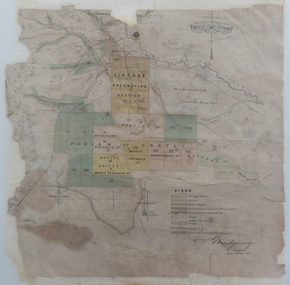 Federation University Historical Collection
Map, Lintons Pre-emptive Section, 1872
... districts lintons claim lintons diggings f w niven nivens steam ...Printed map with coloured shading by F. W Niven Lydiard Street, Ballaratmap, mining districts, lintons claim, lintons diggings, f w niven, nivens steam lithographic machine, f.w. niven -
Federation University Historical Collection
Booklet, Report of the Board Appointed to Advise the Government as to the Best Mode of Developing the Auriferous and Mineral Resources of the Colony, 1879-80, 1880
White Foolscap printed Government document relating Victoria's mineral resources.mineral resources, mining, mining districts, ballarat mining district, auriferous resources, william collard smith, rivett henry bland, henry rosales, robert m. sergeant, a.w. howitt, deep leads, carisbrook, sebastopol, sebastopol plateau, r.m. harvey, james m. main, john wall, g. hale, t.h. thompson, james leckie, e.h. uren, james cotter, p. matthews, w.k. peden, john sharp, g.c. robinson, dead horse lead, william benson, j. keith, smythesdale, charles thorne, haddon, linton, little bendigo, scarsdale, blackwood, daylesford, owen jones, james mcmillan, h.h. sainsbury, thomas bury -
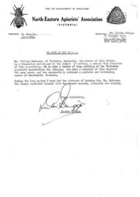 Beechworth Honey Archive
Personal Reference
... pastoralist and beekeeper in the Beechworth District, written... in the Beechworth District, written by Linton Briggs, secretary of North ...Typed reference letter. Personal reference for William Robinson, a foundation member of the association and a recognised pastoralist and beekeeper in the Beechworth District, written by Linton Briggs, secretary of North-Eastern Apiarists' Association (Victoria).personal, reference, beekeeper, robinson, beechworth honey -
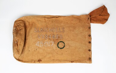 Ballarat RSL Sub-Branch Inc.
Duffle bag
This item was used as a duffele bag to carry equipment (ie. blankets, clothes, food) by the service man, Stanley Linton Nicholls. Nicholls was born in Ballarat on 16 June 1911 and was enlisted during WW2 into the second Australian Imperial Force on 4th August 1942 in the third military district of Victoria. He served as a Corporal and was discharged on 19 December 1945.Canvas bag, cylindrical in shape with closed round base and open, drawstring top. Smaller circle of same material attached inside drawstring opening as an internal cover/flap when closed. Metal eyelets (12) along top hem for drawstring (missing); two eyelets missing. Name and service number inscribed on side of bag in paint; slight staining around paint. Side panel: “S.L. NICHOLLS/VX84489/45017”. Green circle with three line breaks at even intervals. Green circle repeated on base. Base: Green circle as above. “45017”bag, barracks bag, gear bag, kit bag, canvas bag, equipment bag, duffle bag -
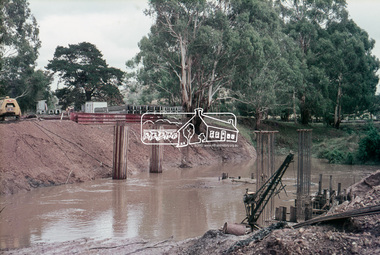 Eltham District Historical Society Inc
Slide, Construction of new bridge, looking upstream from east bank towards existing Lintons Bridge across Arthurs Creek, Doctors Gully Road, Nutfield, 22 February 1972, 1972
35 mm colour positive transparency Mount - Agfacolor Service (Blue)arthurs creek, bridge construction, doctors gully road, eltham shire council, infrastructure, lintons bridge, nutfield -
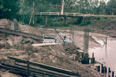 Eltham District Historical Society Inc
Slide, Construction of new bridge, looking downstream from east bank towards existing Lintons Bridge across Arthurs Creek, Doctors Gully Road, Nutfield, 22 February 1972, 1972
35 mm colour positive transparency Mount - Agfacolor Service (Blue)arthurs creek, bridge construction, doctors gully road, eltham shire council, infrastructure, lintons bridge, nutfield -
 Eltham District Historical Society Inc
Slide, Construction of new bridge, looking downstream from west bank towards existing Lintons Bridge across Arthurs Creek, Doctors Gully Road, Nutfield, 22 February 1972, 1972
35 mm colour positive transparency Mount - Agfacolor Service (Blue)arthurs creek, bridge construction, doctors gully road, eltham shire council, infrastructure, lintons bridge, nutfield -
 Eltham District Historical Society Inc
Slide - Photograph, Lintons Bridge, Nutfield, c.Sep. 1989
Part of a slide show presentation "Bridges & Waterways of the Shire" by Russell Yeoman to the 13 September 1989 Society meeting. The presentation included slides of historic photos from the Shire of Eltham Pioneers collections as well as several recent views.35mm colour positive transparency (1 of 15) Mount - Agfa CS System grey 8 dotslintons bridge, nutfield -
 Eltham District Historical Society Inc
Negative - Photograph, Russell Yeoman, Lintons Bridge over Arthurs Creek, c.1970
Now demolished.Roll of 35mm black and white negative film, 4 of 7 strips Associated printIlford HP4bridge, bridges, arthurs creek, doctors gully road, lintons bridge, nutfield -
 Eltham District Historical Society Inc
Photograph, Russell Yeoman, Lintons Bridge over Arthurs Creek, c.1970, 1970c
Now demolished.Roll of 35mm black and white negative film, 4 of 7 stripsIlford HP4bridge, bridges, arthurs creek, doctors gully road, lintons bridge, nutfield -
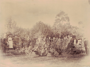 Linton and District Historical Society Inc
Photograph, Ballarat Cycling Club, circa 1880, Late 19th Century
... Linton and District Historical Society Inc 69 Sussex Street ...Found behind fixed shelves at "Hoyles Creek", former home of grazier Mr Sam Lewers. Mr. Sam Lewers (1875-1947) was the son of Linton's first bank manager Mr. Samuel Lewers.Sepia toned image of a group of men and women with penny farthing bicycles. The men appear to be wearing club uniforms. cycling, pennyfarthings, sam lewers -
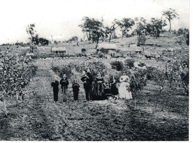 Linton and District Historical Society Inc
Photograph, The Wise Family at Their Property at Linton, circa 1869, 1869
... Linton and District Historical Society Inc 69 Sussex Street ...Family members in this photograph are identified in the book "Dare to be Wise" - L-R: Thomas Wise, born 1858; William Bell Wise, born 1857; John Mardling Wise, born 1860; Thomas Mardling Wise holding baby Joseph James Jonah Wise, born 1868; Mary Bell Wise; Emily Rosina Wise, born 1866; Sarah Ann Wise, born 1854. The girl standing second from right is not identified but is probably Mary Wise, born 1859.Image shows the layout of what a small family holding in the second half of nineteenth century looked like. It also shows cultural and musical items important to the family along with their pets.Black and white copy of original photograph, which shows nine members of the Wise family standing in a row, at their property along Carngham Road at Linton. The photograph shows the layout of the property, with house and stables at rear, animals pens to one side, and orchard at the front. The three young boys in the photograph are holding flutes. The family's dog is lying down in front of the children to the right of the photo.wise family, houses, rural life, thomas mardling wise, mary wise (nee bell), sarah ann wise, william bell wise, thomas wise, mary wise, john mardling wise, joseph james jonah wise, emily wise -
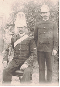 Linton and District Historical Society Inc
Photograph, Linton Brass Band - Mr. Trengrove and Bob Hansen, circa 1903
... Linton and District Historical Society Inc 69 Sussex Street ...Black and white image of two gentlemen wearing the uniform of the Linton Brass Band. The gentleman seated on the left of the image is Mr. Trengrove who was the Drum Major of the band. His uniform is more elaborate than that of Mr. Hansen. He is wearing a light coloured helmet with a horse hair plume, sash and epaulettes. The uniform Bob Hansen is wearing is plain. Both uniforms have extensive frogging. There were various dates of the founding of the brass band. This image is possibly 1903.Text, reverse: POST CARD / FOR CORRESPONDENCE. FOR ADDRESS ONLY / DRUM MAJOR MR. TRENGROVE / & BOB HANSEN.brass bands, musicians, music, mr. trengrove, bob hansen -
 Linton and District Historical Society Inc
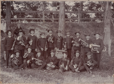
Photograph, Linton Brass Band, Hospital Sunday, Recreation Reserve, 1910
... Linton and District Historical Society Inc 69 Sussex Street ...Black and white image of seventeen men dressed in uniform and holding instruments. One of the men has a small drum sitting in front of him. A man and a woman are visible in the background, behind the band members, sitting on the ground. Further behind them is a post and rail fence with three men standing behind it and a child sitting on the top railing of the fence. Image has been mounted on dark grey card.Text, handwritten, front: ABOUT 1910 LINTON BRASS BAND W. TODD BANDMASTER / Mr TRENGROVE DRUM MAJOR. Text, handwritten, reverse: BACK ROW: GEO PRESTON PADDY TODD / BILLY TODD Mr J SHEPHERD / WILLIAM TODD BAND MASTER / MILTON TODD Mr TRENGROVE DRUM / MAJOR / (HOLDING BATON) / Mr GEO BENNETT Mr ANGUS / DIDDY POWELL / FRONT ROW: ALBERT SIMPER / SOMER DONALDSON ERN CHING / CHARLIE ROBERTS DRUMMER / ARTHUR POWELL PERC ROBERTS J BERSEY / HOSPITAL SUNDAY RECREATION RESERVE / ABOUT 1910.brass bands, musicians, geo preston, paddy todd, billy todd, mr. j. shepherd, william todd, milton todd, mr. trengrove, geo bennett, mr. angus, diddy powell, albert simper, somer donaldson, ern ching, charlie roberts, arthur powell, perc roberts, j. bersey, linton -
 Linton and District Historical Society Inc
Photograph, Linton Brass Band, undated
... Linton and District Historical Society Inc 69 Sussex Street ...Sepia photograph of a group of men wearing suits and hats, most holding a brass instrument, one a drum, in an outdoor setting with children beside and behind them. Photograph has been mounted onto a piece of dark grey card.linton brass band, muscians -
 Linton and District Historical Society Inc
Photograph, Linton Brass Band Outside Todd Bros Butchers, circa 1900
... Linton and District Historical Society Inc 69 Sussex Street ...Mounted black & white photograph of a group of bandsmen and onlookers, in front of Todd Bros Butchers, corner Clyde and Sussex Streets, Linton. brass bands, musicians, streetscapes, butcher shops -
 Linton and District Historical Society Inc
Card - Membership Ticket, Linton Brass Band, 1910
... Linton and District Historical Society Inc 69 Sussex Street ...Small oblong blue & beige cardboard ticket. Probably unused (space for member's name is not filled in). Ticket is for year ending 31st December1910, to be issued to [non-playing] band member on payment of 2/6 subscription. Ticket authorised by W.J. Todd, Hon Sec. A small hole has been punched through upper left corner.Text: Linton Brass Band. / MEMBER'S TICKET / Issued to / For Year ending 31st December, 1910. / SUBSCRIPTION, 2s 6d. / W.J. Todd, / Hon. Sec.brass bands, musicians -
 Linton and District Historical Society Inc
Photograph, Linton Brass Band, 1903
... Linton and District Historical Society Inc 69 Sussex Street ...Black and white image of Linton Brass Band members in uniform with their instruments. Image has been mounted on cream coloured card. There are nineteen band members in the image. Two of the band members have drums in front of them. The rest of the band members have brass instruments. The Band Master is standing in the centre of the image.brass bands, musicians, billy powell, george bersey, dave allen, ern ching, perc roberts, jack todd, arthur suttee, jack simper, lionel trengrove, albert simper, charley roberts, arthur todd, milton todd, george bennett, billy todd, w. angus, arthur powell, albert simper (jnr) -
 Linton and District Historical Society Inc
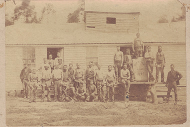
Photograph, 'Glenfine' Shearing Shed, 1890
... Linton and District Historical Society Inc 69 Sussex Street ...In July 1840, Glenfine, consisting of 31,440 acres, was acquired by Thomas Downie. In March 1842 the 'Right of Run' was taken up by Thomas Chirnside who with an imported stallion 'Delapre' ran a horse stud. He apparently lived here for ten years and employed a gardener with a wife and five children from Hobart, Tasmania. Only some blocks of stone and a few trees remain of their homestead. In 1853 the property was transferred to Dr. John Chirnside, an elder brother of Thomas. I, 1857, William Rose of Naringal purchased Glenfiine where he and his family lived until 1904 when it was bought by Richard Howell's estate. It was then 39,000 acres. The present house was built by the Rowes in 1872 of bluestone quarried on the property with a cement render overall. The architect was H.R. Casselli. In 1911 R.C. Howell, son of Richard, became the owner, followed by his son in 1960. Gold was found on the property and by 1898 the township of Hollybush was first reported, situated at either side of the front entrance, on the Cressy Road. The land for the township was given by William Rowe. By 1990 Hollybush had a population of 426 persons. All of the early history of Glenfine, documents etc., were destroyed when Naringal homestead was burnt down in 1944. Glenfine was classified by the National Trust in 1974 and is on the Heritage Commission Register. Mounted black and white image of a large group of men and boys in front of a weatherboard shearing shed. The men are each holding a pair of hand shears. One young man is kneeling on top of a wool bale. A small blue biro 'x' identifies W. Todd. Glenfine was a pastoral station. The original homestead still stands.shearing sheds, shearers, rural activity, william todd, glenfine pastoral station, thomas chirnside, thomas downie, richard howell -
 Linton and District Historical Society Inc
Photograph, Todd and Webb Families in Cars, 1908
... Linton and District Historical Society Inc 69 Sussex Street ...Another copy of this photograph, owned by Judy Maddigan has the inscription: "Taken about 1907 8HP De Dion / Ford owner Dr A.B. Webb / Bill Todd driver of De Dion / Doctor Webb inside Ford /First two cars in Linton / No number plates No Licences / The policeman Mr Robinson asked me / for 2/6 he said Bill you have to have / a Licence to drive these cars so / I never went through a test/ for a Driver's Licence / My licence is in the 2000 mark". Inscription signed: "Wm Todd". Black and white image which shows a man and a woman driving in a Ford motor car, following a man and three children driving in a De Dion motor car. One car is an 8 horsepower De Dion driven by W.J. Todd. The other car is a Ford driven by Dr. Webb at Linton. No driving licence was in force in 1908. The cars have no number plates.vehicles, dr. a.b. webb, william joseph todd -
 Linton and District Historical Society Inc
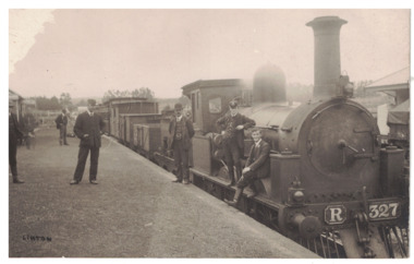
Photograph, Steam Train, Linton Railway Station
... Linton and District Historical Society Inc 69 Sussex Street ...Postcard black and white photograph of men in suits and hats standing on platform beside steam engine R327 at Linton Railway station and two young men sitting on the side front platform of train.Text, reverse: Boy sitting on engine is Harold Morgan, man wearing bowler hat standing beside engine thought to be Mr. Bourke, engine driver, father of Kitty and Lizzie. White house behind station master's cap, weatherboard cottage occupied by Mrs. Howe, her daughter Myra and son Billy. Man on station wearing cap thought to be station master, Alec Thompson's father.steam engines, railways, linton railway station -
 Linton and District Historical Society Inc
Postcard - Photograph, Steam Train, Linton Railway Station
... Linton and District Historical Society Inc 69 Sussex Street ...Postcard which has a black and white image of a steam engine and carriages at Linton Railway Station. The R class engine was constructed at the Phoenix Foundry, Ballarat, between 1881 and 1886.Text, reverse: "Boy sitting on engine is Harold Morgan, man wearing bowler hat standing beside engine thought to be Mr Bourke, engine driver, father of Kitty and Lizzie. White house behind station master's cap, weatherboard cottage occupied by Mrs Howe, her daughter Myra and son Billy. Man on station wearing cap thought to be station master, Alec Thompson's father".linton railway station, steam engines, transport, railways