Showing 175 items matching rail crossing
-
 Whitehorse Historical Society Inc.
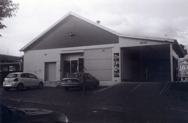
Photograph, Service Station -Now Works Site Office, 1/06/2009
... of Springvale Road so that the Springvale Road Rail Crossing can... of Springvale Road so that the Springvale Road Rail Crossing can ...One of a collection of photographs taken of the Nunawading Railway Station prior to the lowering of the railway line and building of the new railway station on the western side of Springvale Road so that the Springvale Road Rail Crossing can be eliminated.Black & white photograph of he precinct surrounding the Nunawading Station and the Springvale Road Railway crossing. This photograph is former Service Station on west side of Springvale Road. Now works site office. See NP 3545 to NP3567 for the complete set of photographsnunawading railway station, springvale road nunawading, redevelopment of railway line/springvale road. -
 Whitehorse Historical Society Inc.
Photograph, Railway Track Looking East, 1/06/2009
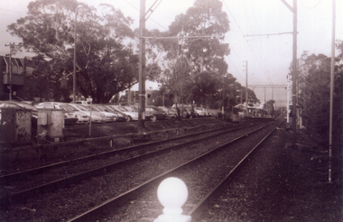
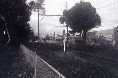
... of Springvale Road so that the Springvale Road Rail Crossing can... that the Springvale Road Rail Crossing can be eliminated. nunawading railway ...One of a collection of photographs taken of the Nunawading Railway Station prior to the lowering of the railway line and building of the new railway station on the western side of Springvale Road so that the Springvale Road Rail Crossing can be eliminated.Black & white photograph of he precinct surrounding the Nunawading Station and the Springvale Road Railway crossing. This photograph is of the railway track looking east from railway crossing in Springvale road. Note the railway station in the distance. See NP 3545 to NP3567 for the complete set of photographsnunawading railway station, springvale road nunawading, redevelopment of railway line/springvale road. -
 Whitehorse Historical Society Inc.
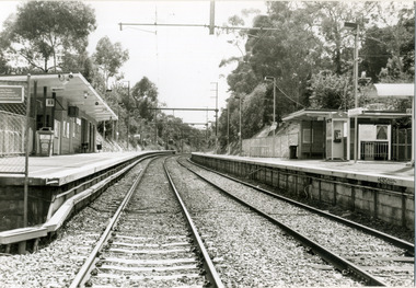
Photograph, Railway tracks looking west, 1/06/2009
... of Springvale Road so that the Springvale Road Rail Crossing can... of Springvale Road so that the Springvale Road Rail Crossing can ...One of a collection of photographs taken of the Nunawading Railway Station prior to the lowering of the railway line and building of the new railway station on the western side of Springvale Road so that the Springvale Road Rail Crossing can be eliminated.Black & white photograph of he precinct surrounding the Nunawading Station and the Springvale Road Railway crossing. This photograph is the railway crossing and tracks looking west to Blackburn. See NP 3545 to NP3567 for the complete set of photographsnunawading railway station, springvale road nunawading, redevelopment of railway line/springvale road. -
 Whitehorse Historical Society Inc.
Photograph, Looking across crossing towards liquor store, 1/06/2009
... of Springvale Road so that the Springvale Road Rail Crossing can... Mitcham melbourne Photograph Photograph Looking across crossing ...One of a collection of photographs taken of the Nunawading Railway Station prior to the lowering of the railway line and building of the new railway station on the western side of Springvale Road so that the Springvale Road Rail Crossing can be eliminated.Black & white photograph of he precinct surrounding the Nunawading Station and the Springvale Road Railway crossing. This photograph is the view looking across railway crossing towards liquor store. See NP 3545 to NP3567 for the complete set of photographsnunawading railway station, springvale road nunawading, redevelopment of railway line/springvale road. -
 Whitehorse Historical Society Inc.
Photograph, Nunawading Station looking from the north side, 1/06/2009
... of Springvale Road so that the Springvale Road Rail Crossing can... crossing. This photograph is the station looking from the entrance ...One of a collection of photographs taken of the Nunawading Railway Station prior to the lowering of the railway line and building of the new railway station on the western side of Springvale Road so that the Springvale Road Rail Crossing can be eliminated.Black & white photograph of he precinct surrounding the Nunawading Station and the Springvale Road Railway crossing. This photograph is the station looking from the entrance of station on the north side of the tracks. See NP 3545 to NP3567 for the complete set of photographsnunawading railway station, springvale road nunawading, redevelopment of railway line/springvale road. -
 Whitehorse Historical Society Inc.
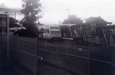
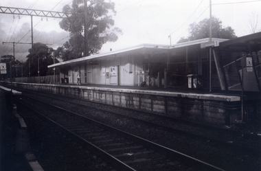
Photograph, Railway Platform from south side, 1/06/2009
... of Springvale Road so that the Springvale Road Rail Crossing can... that the Springvale Road Rail Crossing can be eliminated. nunawading railway ...One of a collection of photographs taken of the Nunawading Railway Station prior to the lowering of the railway line and building of the new railway station on the western side of Springvale Road so that the Springvale Road Rail Crossing can be eliminated.Black & white photograph of the precinct surrounding the Nunawading Station and the Springvale Road Railway crossing. This photograph is railway station looking from north side of station. See NP 3545 to NP3567 for the complete set of photographsnunawading railway station, springvale road nunawading, redevelopment of railway line/springvale road. -
 Whitehorse Historical Society Inc.
Photograph, Station seen from north side-Platform, 1/06/2009
... of Springvale Road so that the Springvale Road Rail Crossing can... of Springvale Road so that the Springvale Road Rail Crossing can ...One of a collection of photographs taken of the Nunawading Railway Station prior to the lowering of the railway line and building of the new railway station on the western side of Springvale Road so that the Springvale Road Rail Crossing can be eliminated.Black & white photograph of he precinct surrounding the Nunawading Station and the Springvale Road Railway crossing. This photograph is a close up view of the south platform at Nunawading from the north side.|See NP 3545 to NP3567for the complete set of photographsnunawading railway station, springvale road nunawading, redevelopment of railway line/springvale road. -
 Whitehorse Historical Society Inc.
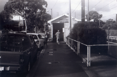
Photograph, Looking to Booking Office on North side of Nunawading Station, 1/06/2009
... of Springvale Road so that the Springvale Road Rail Crossing can... that the Springvale Road Rail Crossing can be eliminated. nunawading railway ...One of a collection of photographs taken of the Nunawading Railway Station prior to the lowering of the railway line and building of the new railway station on the western side of Springvale Road so that the Springvale Road Rail Crossing can be eliminated.Black & white photograph of he precinct surrounding the Nunawading Station and the Springvale Road Railway crossing. This photograph is the entrance to the Booking Office for trains from Nunawading travelling east. See NP 3545 to NP3567 for the complete set of photographsnunawading railway station, springvale road nunawading, redevelopment of railway line/springvale road. -
 Whitehorse Historical Society Inc.
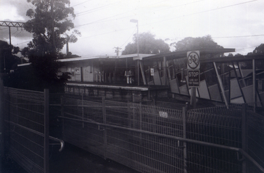
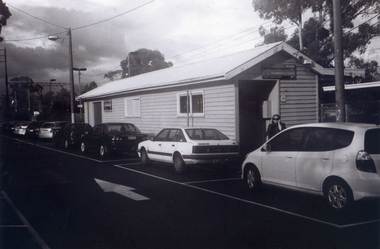
Photograph, Nunawading Station - North Side, 1/06/2009
... of Springvale Road so that the Springvale Road Rail Crossing can... the Nunawading Station and the Springvale Road Railway crossing ...One of a collection of photographs taken of the Nunawading Railway Station prior to the lowering of the railway line and building of the new railway station on the western side of Springvale Road so that the Springvale Road Rail Crossing can be eliminated.Black & white photograph of he precinct surrounding the Nunawading Station and the Springvale Road Railway crossing. This photograph is of the Booking Office and Waiting Rooms on the North side of the Nunawading Station . See NP 3545 to NP3567 for the complete set of photographsnunawading railway station, springvale road nunawading, redevelopment of railway line/springvale road. -
 Whitehorse Historical Society Inc.
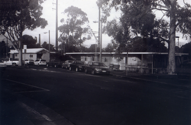
Photograph, General View of Nunawading Station, 1/06/2009
... of Springvale Road so that the Springvale Road Rail Crossing can... the Nunawading Station and the Springvale Road Railway crossing ...One of a collection of photographs taken of the Nunawading Railway Station prior to the lowering of the railway line and building of the new railway station on the western side of Springvale Road so that the Springvale Road Rail Crossing can be eliminated.Black & white photograph of he precinct surrounding the Nunawading Station and the Springvale Road Railway crossing. This photograph is view of the Nunawading Railway Station from Walker Road, showing the North an South Platforms. See NP 3545 to NP3567 for the complete set of photographsnunawading railway station, springvale road nunawading, redevelopment of railway line/springvale road., walkers road nunawading -
 Whitehorse Historical Society Inc.
Photograph, Liquor Store fro Silver Grove Car park, 1/06/2009
... of Springvale Road so that the Springvale Road Rail Crossing can... of Springvale Road so that the Springvale Road Rail Crossing can ...One of a collection of photographs taken of the Nunawading Railway Station prior to the lowering of the railway line and building of the new railway station on the western side of Springvale Road so that the Springvale Road Rail Crossing can be eliminated.Black & white photograph of the precinct surrounding the Nunawading Station and the Springvale Road Railway crossing. This photograph is the rear of the liquor store in Springvale Road.cSee NP 3545 to NP3567for the complete set of photographsnunawading railway station, springvale road nunawading, redevelopment of railway line/springvale road. -
 Whitehorse Historical Society Inc.
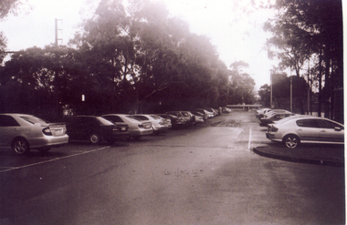
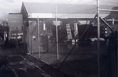
Photograph, Car Park - rear of Recreation Centre, 1/06/2009
... of Springvale Road so that the Springvale Road Rail Crossing can... that the Springvale Road Rail Crossing can be eliminated. nunawading railway ...One of a collection of photographs taken of the Nunawading Railway Station prior to the lowering of the railway line and building of the new railway station on the western side of Springvale Road so that the Springvale Road Rail Crossing can be eliminated.Black & white photograph of he precinct surrounding the Nunawading Station and the Springvale Road Railway crossing. This photograph is of the car park on north side of railway line and west side of Springvale Road behind the Recreation Centre. This will be site of new station. See NP 3545 to NP3567 for the complete set of photographsnunawading railway station, springvale road nunawading, redevelopment of railway line/springvale road. -
 Whitehorse Historical Society Inc.
Photograph, Railway Station from Car Park, 1/06/2009
... of Springvale Road so that the Springvale Road Rail Crossing can... that the Springvale Road Rail Crossing can be eliminated. nunawading railway ...One of a collection of photographs taken of the Nunawading Railway Station prior to the lowering of the railway line and building of the new railway station on the western side of Springvale Road so that the Springvale Road Rail Crossing can be eliminated.Black & white photograph of the precinct surrounding the Nunawading Station and the Springvale Road Railway crossing. This photograph is of the station taken from the car park on west side of Springvale Road, north of railway line behind Recreation Centre. See NP 3545 to NP3567 for the complete set of photographsnunawading railway station, springvale road nunawading, redevelopment of railway line/springvale road, nunawading recreation centre -
 Whitehorse Historical Society Inc.
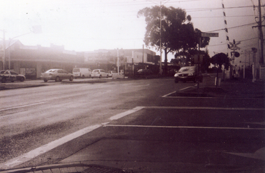
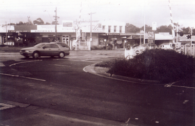
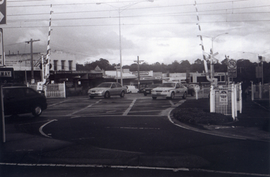
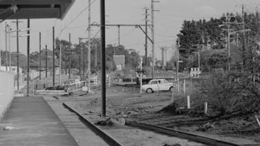
Photograph, Railway crossing on Springvale Road, 1/06/2009
... of Springvale Road so that the Springvale Road Rail Crossing can... of Springvale Road so that the Springvale Road Rail Crossing can ...One of a collection of photographs taken of the Nunawading Railway Station prior to the lowering of the railway line and building of the new railway station on the western side of Springvale Road so that the Springvale Road Rail Crossing can be eliminated.Black & white photograph of the precinct surrounding the Nunawading Station and the Springvale Road Railway crossing. This photograph is the railway crossing with Springvale Road, Nunawading, taken from the north west corner looking over crossing to some of the Nunawading shops. See NP 3545 to NP3567 for the complete set of photographsnunawading railway station, springvale road nunawading, redevelopment of railway line/springvale road., nunawading recreation centre -
 Whitehorse Historical Society Inc.
Photograph, Railway Crossing from the north, 1/06/2009
... of Springvale Road so that the Springvale Road Rail Crossing can... Mitcham melbourne Photograph Photograph Railway Crossing from ...One of a collection of photographs taken of the Nunawading Railway Station prior to the lowering of the railway line and building of the new railway station on the western side of Springvale Road so that the Springvale Road Rail Crossing can be eliminated.Black & white photograph of the precinct surrounding the Nunawading Station and the Springvale Road Railway crossing. This photograph is of the railway crossing of Springvale Road, Nunawading, looking to the south of the shops. See NP 3545 to NP3567 for the complete set of photographsnunawading railway station, springvale road nunawading, redevelopment of railway line/springvale road. -
 Whitehorse Historical Society Inc.
Photograph, Site Office for the Construction of new crossing and station, 1/06/2009
... of Springvale Road so that the Springvale Road Rail Crossing can... of Springvale Road so that the Springvale Road Rail Crossing can ...One of a collection of photographs taken of the Nunawading Railway Station prior to the lowering of the railway line and building of the new railway station on the western side of Springvale Road so that the Springvale Road Rail Crossing can be eliminated. Black & white photograph of the precinct surrounding the Nunawading Station and the Springvale Road Railway crossing. This photograph is of the Site Office for the work associated with lowering of railway line and construction of new railway station. See NP 3545 to NP3567for the complete set of photographsnunawading railway station, redevelopment of railway line/springvale road., springvale road nunawading -
 Whitehorse Historical Society Inc.
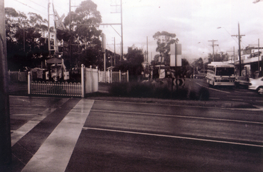
Photograph, Pedestrian Crossing & Nunawading Railway Station, 1/06/2009
... of Springvale Road so that the Springvale Road Rail Crossing can... that the Springvale Road Rail Crossing can be eliminated. nunawading railway ...One of a collection of photographs taken of the Nunawading Railway Station prior to the lowering of the railway line and building of the new railway station on the western side of Springvale Road so that the Springvale Road Rail Crossing can be eliminated.Black & white photograph of the precinct surrounding the Nunawading Station and the Springvale Road Railway crossing. This photograph is looking over the south side of the intersection in Springvale, to the pedestrian crossing and the Railway Station. The shopping centre is on the right hand side. See NP 3545 to NP3567 for the complete set of photographsnunawading railway station, springvale road nunawading, redevelopment of railway line/springvale road. -
 Whitehorse Historical Society Inc.
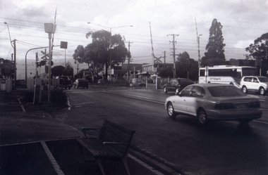
Photograph, Railway Crossing from the south, 1/06/2009
... of Springvale Road so that the Springvale Road Rail Crossing can... that the Springvale Road Rail Crossing can be eliminated. nunawading railway ...One of a collection of photographs taken of the Nunawading Railway Station prior to the lowering of the railway line and building of the new railway station on the western side of Springvale Road so that the Springvale Road Rail Crossing can be eliminated.Black & white photograph of the precinct surrounding the Nunawading Station and the Springvale Road Railway crossing. This photograph is south side of the crossing looking north. See NP 3545 to NP3567 for the complete set of photographsnunawading railway station, springvale road nunawading, redevelopment of railway line/springvale road. -
 Greensborough Historical Society
Photograph - Digital Image, Watsonia Railway Station before 1970, 1960s
... the rail crossing at the old station. The new Watsonia Station... the rail crossing at the old station. The new Watsonia Station ...Watsonia Station before the 1970s. This photograph shows the rail crossing at the old station. The new Watsonia Station was opened in 1977 when the rail line was lowered to remove level crossings such as this and duplicate the line between Macleod and Greensborough.Digital copy of black and white photographwatsonia station, hurstbridge rail line -
 Whitehorse Historical Society Inc.
Photograph, Railway Station, Heatherdale|Railway Stations, 2000
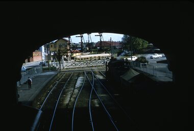
... of Heatherdale Railway Station, viewed from the Heatherdale Rail Crossing... the Heatherdale Rail Crossing. L-R West bound station platform for travel ...Produced as one of a series of 24 prints commissioned by Nunawading & District Historical Society -|Theme: Intersections of Mitcham and Nunawading 2000/2001.|See also Series by P. Simmenauer on the same theme.Black and white photograph - print and negative of Heatherdale Railway Station, viewed from the Heatherdale Rail Crossing. L-R West bound station platform for travel to City of Melbourne, next station is Mitcham. Right hand side Eastbound platform - next stop Ringwood, where some trains travel S.E. to Belgrave and some N.E. to Lilydale. Heatherdale is last station in fare Zone 2 and 1st station in Fare Zone 3. Note Telstra Phonebox on platformheatherdale railway station -
 Ballarat Tramway Museum
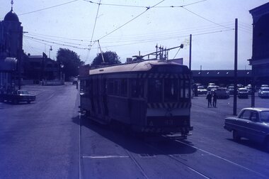
Slide - 35mm slide/s, Ben Parle, 8/04/1958 12:00:00 AM
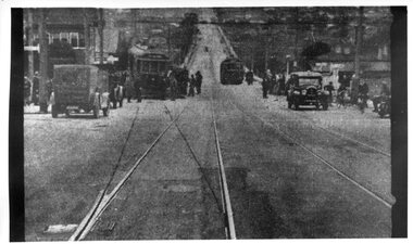
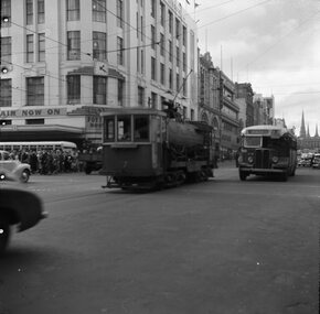
... . Photo of Ballarat No. 42 crossing the rail crossing, Lydiard St... of Ballarat No. 42 crossing the rail crossing, Lydiard St. North ...Kodachrome Transparency - 35mm slide - cardboard mount, with one side with red border and words "Kodachrome Transparency / Processed by Kodak" top and bottom. Photo taken by Ben Parle 8/4/1958. Has slide No. "16" stamped in red in top corner. Photo of Ballarat No. 42 crossing the rail crossing, Lydiard St. North, Ballarat Railway Station. Taken from the footbridge within the station roof. A K class hauled goods is waiting on platform No. 2 to leave the station. Has the signal gantry and "B" signal box in the background. "Lydiard St Ballarat 8-4-58"tramways, trams, lydiard st, railway, level crossings, ballarat railway station, tram 42 -
 Melbourne Tram Museum
Photograph - Derailment of MMTB N Class tram 121 at Riversdale Road level Crossing, Herald Sun, 8-9-1928
... at rail crossings to deliberately derail a runaway tram when... at rail crossings to deliberately derail a runaway tram when ...Newspaper photograph - from the Melbourne Herald Sun Pictorial newspaper - 8/ 9/1928 about the derailment after running through the catch points of a maximum traction tramcar at the Riversdale Road level crossing the previous day 7/9/1928. The front bogie or truck has been torn from underneath the tramcar. A check with The Sun microfilm at the State Library shows the paper was published on 8/9/1928. Refer Item 1781. Note that the catch point on the down track has opened which caused the tram heading east to derail. Catch points were installed at tram tracks at rail crossings to deliberately derail a runaway tram when a train is approaching or is on the crossing. Occasionally the catch point does not close after the train has passed. Yields information about the amount of damage to the tram following a derailment to a maximum traction tram at Riversdale Road in 1928.Newspaper clipping from The Melbourne Herald Sun 8-9-1928 or another newspapertramways, tramcars, derailments, accidents, level crossings, riversdale road, tram 121, n class -
 Ballarat Tramway Museum
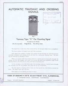
Pamphlet, The Forest City Electric Co. Limited England, "Automatic Tramway and Crossing Signals", c1948
... for automatic control signals for rail crossings on roads, docks etc... and Crossing Signals" Four page Pamphlet or Brochure Forest City ATS1 ...Yields information about the types of tramway signals available for use on tramways systems. The type BY was used by the SEC in Ballarat and Bendigo.Four page Pamphlet or Brochure Forest City ATS1, printed brochure with illustrations "Automatic Tramway and Crossing Signals" – four types noted. Four types: 1. Tramway type "C: Car counting signal, up to 10 cars 2. Tramway type "BY" - non car counting signals 3. Level crossing signal operated by approaching cars 4. Turning Warning signals with notes on rear page of the set up for automatic control signals for rail crossings on roads, docks etc. Date stamped by SEC 20/9/1949 on front cover.Has “218” in biro in bottom left hand corner.trams, tramways, forest city signals, level crossings, signals -
 Glen Eira City Council History and Heritage Collection
Document (Item) - Newspaper (digital), Caulfield Contact, 1977
... -Glenhuntly Football Club formed Council drops approval of rail... Club formed Council drops approval of rail crossings over ...The Caulfield Contact was the official newspaper of the City of Caulfield from 1976-1994. The City of Caulfield was the Municipal Council for an area of the South Eastern suburbs of Melbourne, including Brighton East, Carnegie, Caulfield, Elsternwick, Gardenvale, Glen Huntly, McKinnon, Murrumbeena, Ormond and St Kilda East. Following Amalgamation of City of Caulfield and parts of the City of Moorabbin in 1994, the Caulfield Contact was followed by the Glen Eira News. Includes references to the following: Children's Neighbourhood Centre Caulfield; Fire destroyed Caulfield Park Bowling Club; Naming of Harleston Park; Home Handyman Service; Profiles Councillors Peter Baitz, Ron Walters; Carnegie-Glenhuntly Football Club formed Council drops approval of rail crossings over Neerim and Glenhuntly Roads; Profiles Councillor Alwyn Samuel, Glen Richards; First stage of Nepean Highway widening; Minister approved re-subdivision; Council spills; Exciting development of Caulfield Park; Profiles Councillor Max Blair, Councillor Brian Rudzki; Tram shelter classified by National Trustcity of caulfield, caulfield, glen eira, city of glen eira, caulfield contact, children's neighbourhood centre caulfield, fire destroyed caulfield park bowling club, naming of harleston park, home handyman service, profiles councillors peter baitz, ron walters, carnegie-glenhuntly football club formed, council drops approval of rail crossings over neerim and glenhuntly roads, profiles councillor alwyn samuel, glen richards, first stage of nepean highway widening, minister approved re-subdivision, council spills, exciting development of caulfield park, profiles councillor max blair, councillor brian rudzki, tram shelter classified by national trust -
 Ballarat Tramway Museum
Negative, Geoff Grant, 24/06/1955 12:00:00 AM
... car for flushing rail grooves crossing Swanston St. in Bourke... ) of MMTB works car No. 7, bogie tank car for flushing rail grooves ...Negative No. N337 and black and white print made by a laser printer (stored in folder ) of MMTB works car No. 7, bogie tank car for flushing rail grooves crossing Swanston St. in Bourke St., heading west with Foy and Gibsons building in the background. Photo taken Friday 24/6/1955. Alongside No. 7 is a Spencer St. bus Negative scanned hi res and imaged updated 22/5/2020.trams, tramways, melbourne, bourke st, swanston st., work trams, tram 7 -
 Puffing Billy Railway
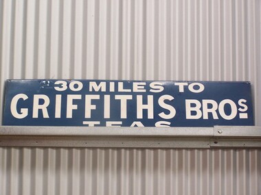
Sign - Advertising - Griffiths Tea Sign - 30 Miles, between 1879 - 1930's
... rail crossing accident at Bayswater in 1925. Despite... rail crossing accident at Bayswater in 1925. Despite ...In 1879, James Griffiths established one of Australia’s first tea and coffee distribution companies at 30 Flinders St, Melbourne, which is now, occupied by the boutique Lindrum Hotel. Established with his brother John, recent immigrants from England, Griffiths occupied the highest position in the commercial world during their many years as distributors of tea, coffee, cocoa and other products throughout Victoria and Australia. The Griffiths brand was a guarantee for quality of product and service as it still is today. This extensive service was provided to customers via horse drawn carts serviced by rail from Melbourne. As a spirited entrepreneur, Griffiths made his company a household name through his pioneering use of outdoor advertising by installing the infamous blue and white enamel “Griffiths Tea” promotional signs affixed to the railway boundary fences highlighting to travellers the distance to or from Melbourne, indicating so many “— miles to Griffiths Tea”. These signs, much sought after today, were well known through out the eastern states. Photographs have been published of a sign erected by a Digger in France during the First World War with the words “1100 miles to Griffiths Bros”. Tragically, James and his wife Emily with friends died in a level rail crossing accident at Bayswater in 1925. Despite this unfortunate accident, Griffiths and its culture of innovation has survived as one of the few 100% Australian owned coffee roasters, with only three owners in 128 years. http://www.griffithscoffee.com.au/about-us/back-to-1879/ Sign - Advertising - Griffiths Tea Sign - 30 MilesHistoric - Sign - Advertising - Griffiths Tea Sign - used along side of Victorian Railway lines and at StationsSign - Advertising - Griffiths Tea Sign - 30 Miles Griffiths Tea sign made of Enamel paint on metal sign30 Miles to Griffiths Tea Sign puffing billy, sign - advertising - griffiths tea sign - 30 miles -
 Melbourne Tram Museum
Photograph - Set of 12 Black & White Photograph/s, Melbourne & Metropolitan Tramways Board (MMTB), 1966
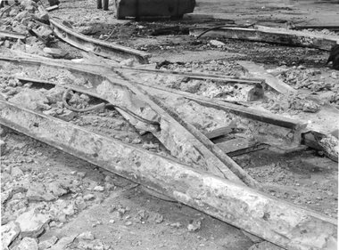
... dog spikes. .8 - crossing possibly between tram and rail... and rail .9 - H crossing rail showing broken joints and wear ...Series of 12 black and white photographs of the trackwork on the MMTB system. .1 - demolished track at a junction .2 - section of rail showing the flangeway missing .3 - junction plates between different weight railway . .4 - wood blocked track showing broken joint and failure .5 - ditto .6 - V crossing ,7 - ditto at a wooden sleepered crossing with puppy dog spikes. .8 - crossing possibly between tram and rail .9 - H crossing rail showing broken joints and wear .10 - ditto .11 - section of rail pumping - waterlogged .12 - damaged joint, pumping, broken joint plate.trams, tramways, trackwork, rails, points, crossover, track materials, track repairs -
 Melbourne Tram Museum
Document - Research Notes, H. S. McComb, "Orders in Council - Relating to Bridges", c1930
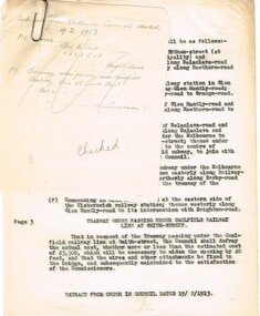
... lines 16 - Commercial Road and rail crossings 17 - MMTB Act... road and rail lines 16 - Commercial Road and rail crossings ...Type and hand written notes, on quarto or scrap paper about Orders in councils relating to Melbourne Tramway bridges - 17 sets of notes, each retained by a paper clip. 1 - Caulfield line at Smith St 2 - Church St Bridge Act 3 - Spencer St Bridge Act 4 - Melbourne to Burwood Tramways Act 5 - Footscray Tramway Act 6 - Fitzroy Northcote and Preston Tramways Act 7 - Hawthorn - Under line at Burwood and over line at Burnley 8 - Burke Road Camberwell 9 - St Kilda rail line at Kerford Road 10 - High St Deepdene - Fairfield to Deepdene line. 11 - Glenferrie - Glenferrie Road 12 - Prahran and Malvern Act 13 - Brunswick and Coburg Tramways Act 14 - PMTT - Caulfield and Sandringham rail lines 15 - Glenferrie and Wattletree road and rail lines 16 - Commercial Road and rail crossings 17 - MMTB Act 1928 - various provisionstrams, tramways, bridges, pmtt, mmtb, glenferrie rd, camberwell, htt, mbctt, ftt, fnptt, railways -
 Melbourne Tram Museum
Photograph - Black & White Photograph/s, 2009
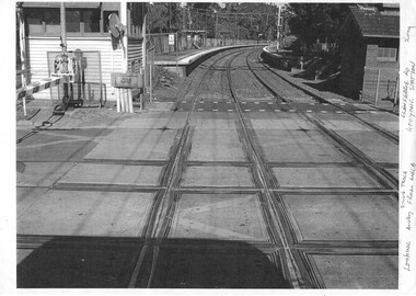
... - of the rail tram level crossing at Glenferrie Road, Kooyong showing... - of the rail tram level crossing at Glenferrie Road, Kooyong showing ...Set of two Photographs printed on A4 sheet, photocopy - of the rail tram level crossing at Glenferrie Road, Kooyong showing the rubber inserts and the level crossing - taken from the cab of a train in either direction. Shows the level crossing, platform and track, along with part of the signal box and boom barriers.1 - "Looking away down track from Melbourne - Glenferrie Rd Kooyong Station - 2009" 2 - "Looking towards Melbourne up track - Glenferrie Rd Kooyong Station - 2009"trams, tramways, kooyong, level crossings, glenferrie road, tramway square, railway squares -
 Ballarat Tramway Museum
Slide - 35mm slide/s, Travis Jeffrey, late 1960's
... , Reid's Coffee Palace and the rail level crossing gates... Palace and the rail level crossing gates and Victoria House ...Agfa plastic mount (blue base, white cover) of a photograph of No. 43 southbound in Lydiard St Nth entering the double track section. Photo taken late 1960's. Has the Provincial Hotel, Reid's Coffee Palace and the rail level crossing gates and Victoria House in the background. Tramcar has an "Everything's under control in my all electric kitchen" roof advertisement. Slide rescanned at 3200 dpi 25-10-2020, jpg replaced, tiff file retained. This file was scanned in 2003 and may show colour changes."BAS 48" in penciltramways, trams, railway station, lydiard st nth, tram 43