Showing 12 items matching settlement on the murray river
-
 Wodonga & District Historical Society Inc
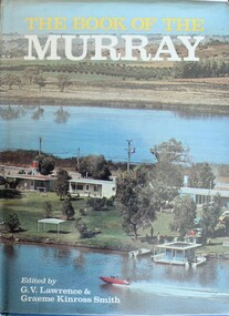
Book - The Book of the Murray, Lawrence, G. V.; and Smith, Graeme Kinross, 1975
... settlement on the Murray River... of 264 pages. Murray River Australian geography settlement ...This book contains contributions from 16 writers who have first-hand knowledge of the Murray River area. It provides a comprehensive picture of the river in all its aspects. It gives a fascinating look at one of Australia's most important geographical and historical features. Contributors and chapters in this book are: - 1. Past, Present and Future – G. V. Lawrence 2. The Structure of the Murray – Edmund D. Gill 3. Seeing the Murray – Graeme Kinross Smith 4. The Mountains at the Source – Elyne Mitchell 5. The Explorers – Leigh Betheras 6. The Irrigators – G. Arch Grosvenor 7. Murray Water Conservation – W. G. L. Harrison & K. E. Johnson 8. The Murray River Steamers – Ian Mudie 9. Pioneer Days: A Story of Seventy Years Ago – Dorothy Roysland 10. Birdlife of the Murray Valley – John Eckert 11 .Aborigines in the Murray Valley, How We Learned the Story – H. A. Lindsay, The Aboriginal Occupation – Norman B. Tindale 12. Fish of the Murray River – John S. Lake 13. Native Plants of the Murray Valley – J. H. Willis 14. Murray Wildlife – K. N. G. SimpsonThis publication has a hard cover with blue boards and a pictorial dust jacket. It consists of 264 pages.This book contains contributions from 16 writers who have first-hand knowledge of the Murray River area. It provides a comprehensive picture of the river in all its aspects. It gives a fascinating look at one of Australia's most important geographical and historical features. Contributors and chapters in this book are: - 1. Past, Present and Future – G. V. Lawrence 2. The Structure of the Murray – Edmund D. Gill 3. Seeing the Murray – Graeme Kinross Smith 4. The Mountains at the Source – Elyne Mitchell 5. The Explorers – Leigh Betheras 6. The Irrigators – G. Arch Grosvenor 7. Murray Water Conservation – W. G. L. Harrison & K. E. Johnson 8. The Murray River Steamers – Ian Mudie 9. Pioneer Days: A Story of Seventy Years Ago – Dorothy Roysland 10. Birdlife of the Murray Valley – John Eckert 11 .Aborigines in the Murray Valley, How We Learned the Story – H. A. Lindsay, The Aboriginal Occupation – Norman B. Tindale 12. Fish of the Murray River – John S. Lake 13. Native Plants of the Murray Valley – J. H. Willis 14. Murray Wildlife – K. N. G. Simpsonmurray river, australian geography, settlement on the murray river, native plants, aborigines in the murray valley, murray valley flora and fauna -
 Federation University Historical Collection
Report, Sarah Portanier, Sequestering the Past: The Commemoraton of Pioneering Life at Australia's First Outdoor Museum: Swan Hill Pioneer Settlement 1961-1998, 1999
White bound report with clear cover and white plastic ring bindingoutdoor museums, swan hill pioneer settlement, p.s. gem, paddle steamer, swan hill, chemist, post office, historical parks, murray river, swan hill folk museum, j.m. cohn, r.g. holloway, heritage experience, interpretation -
Marysville & District Historical Society
Article (item) - Book Extract, Aboriginal History, Unknown
An extract from a book regarding a brief history of the Kulin nation of the North Central district of Victoria.An extract from a book regarding a brief history of the Kulin nation of the North Central district of Victoria. This history covered is both prior to European history and post-European history. The extract also covers current (1991) status of Aboriginal affairs and European settlement of the area.kulin nation, woiworung, taungurong, bunurong, watherong, jajowrong, wurrundjeri-willam, waring-ilam-balluk, goulburn valley, acheron valley, upper goulburn district, eildon-thornton, eildon homestead, o'rourke, thornton, assistant protector thomas, yarra valley, kilmore, mount william, jt gellibrand, william buckley, major mitchell, port phillip, murray river, yorta yorta, yowung-illam-balluk, waring-illam-balluk, ngurai-illam-wurrung, kurnai nation, protectorate system, victoria, george robinson, chief protector, willam thomas, james dredge, edward parker, charles sievewright, central board for the protection of aborigines, presbyterian mission, anglican mission, moravian mission, wonga, munnarin, beaning, murrin murrin, parugean, baruppin, koo-gurrin, acheron river, little river, acheron run, peter snodgrass, stephen jones, barak, dividing range, black spur, watts river, badger creek, healesville, coranderrk, victorian christmas bush, aboriginal and torres strait islander heritage protection act 1984, archaelological and aboriginal relics preservation act 1972, camp jungai, rubicon, warrawa college, victorian archaeological survey, hume and hovell, molesworth, broadford, william hamilton, alexandra, mansfield, avenel, tallarook, worrough, john cotton, trawool valley, seymour, pyalong, gold mining, central victoria, strath creek, reedy creek, yea, jamieson, marysville, jordan goldfields, comet mine, wandong, melbourne-albury railway, rabbit plague, narbethong, lord kitchener, puckapunyal military camp, 1944 decentralisation policy, eildon weir, hume freeway bypass, timber industry, australian paper manufacturers mill -
 Wycheproof & District Historical Society Inc.
Bunguluke Map, Bunguluke District In 1923, 27.2.1923
By 1881 Bunguluke was a small settlement as recorded, December 5, in the Charlton "Mercury". It reports that in that year Draper's Store, Hotel and Post Office and residence at Bunguluke North was totally destroyed by fire. For years now there has been little sign of community life with houses few and far between and acreages have gone into larger holdings. The map references land blocks and owners for that era.This important map shows the local land ownership and local features that existed in 1923. This is a photocopied black and white map of Bunguluke in the County of Kara Kara, Number L5149. Marked - Photo Lithographed by W.J. Butson 27.2.1923. The details include numbers of allotments, property owners, roads, rivers. The boundaries marked are the Parish of Jeruk, Parish of Wycheproof, Parish of Cooroopajerrup. Wycheproof township location is shown with the Scale of Chains. Bunguluke maps for other years are also in the collection.map, bunguluke, jeruk, wycheproof, cooroopajerrup -
 Surrey Hills Historical Society Collection
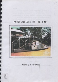
Book, Paddle wheels of the past
The discovery of inland waterways during the early settlement of Victoria and South Australia led to trade being plied up and down the rivers.An A4 80 page comb bound book.paddlewheels, paddlesteamers - murray river (nsw- sa), boats, punts, barges -
Tatura Irrigation & Wartime Camps Museum
Folder, The Mighty Murray, 1993
Compiled by a group of teachers. Based on original concept by David Eastburn. Distributed as a teachers' aid. Assists in research developing their ability to formulate and test hypothesesRiver scenes (Murray and Darling). Educational information.|Includes aboriginal early population to present day settlement. Early map 1902the mighty murray, murray darling basin, huggan h, tatura, water, documents, education -
 Victorian Aboriginal Corporation for Languages
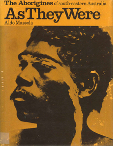
Book, Aldo Massola, The Aborigines of south-eastern Australia : as they were, 1971
Contents: p.1-3; Origins, arrival in Australia; p.4-9; How they lived - camp sites, dating (including carbon dating); p.10-27; Physical appearance, skin colour, hair, clothing, body ornaments, cicatrization; exchange system, distribution of food, marriage &? sexual relations; the tribe - structure, relationship to land, territory, gives map showing locations of tribes, New South Wales, Victoria &? eastern South Australia, leadership, government, division of labour, status of women, estimated population at white settlement, density of population (Victoria); p.28-31; Language - names &? naming, reproduces Wembawemba vocabulary, notes use of secret languages, gives 12 rules for pronounciation; p.32-53; Religion, spirit beliefs, totemism, moieties, phratries, marriage rules; mythology, gives eaglehawk &? crow myth from Lake Victoria &? other myths illustrating origins of fire &? natural rock formations, mythical beasts (Bunyip, Mindie), stellar beliefs; magic, medicine men, powers, native remedies for sickness, describes ceremony held in Melbourne, 1847 to avert evil, sorcery, pointing bone, love magic, rain makers; messengers, appearance, etiquette, message sticks; p.54-71; Rock art, motifs, colours, decorative art, engraving of utensils, rock engravings, manufacture &? use of pigments, engraving techniques; trade system, objects bartered, meeting places for trade (Victoria), map shows possible routes (south east Australia); corroborees, purpose, body ornaments &? decorations, musical instruments; p.72-93; Ceremonial life, marriage, punishment for infidelity, birth, childhood, games &? amusements, initiation, etiquette of visiting tribes, details of ceremony, womens role, earth figures &? ground designs, bull roarers, female puberty ceremonies; p.94-133; Shelters, fire making, cooking, construction of canoes, wooden implements, use of reeds, animal skins &? sinews, shells; stone tools, cylindro conical stones, scrapers, knives &? microliths; hunting weapons, spear, other methods pits, nets; fishing methods &? spears, traps; food sharing, womens responsibilities for collecting, digging stick, cooking methods, insect foods, plant foods, water resources; manufacture &? use of spears, spear throwers, shields, clubs, boomerangs; inter- &? intratribal fighting; p.134-147; Death, disposal of body - eating of the dead, burial, cremation, platform exposure, dendroglyphs (N.S.W.), Aboriginal burial grounds (Darling &? Murray Rivers), mourning, widowhood, kopi caps (N.S.W.), causes of death, inquest ceremonies, revenge expedition, after death beliefs; p.148-157; The end of the tribes white settlement &? its impact on Aboriginal life, friction between natives &? settlers, establishment of Protectorates; copiously illustrated throughout.maps, b&w illustrations, b&w photographswemba wemba, murray river, darling river, lake victoria -
 Wonthaggi & District Historical Society
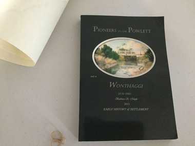
Book and Map, Barbara Moyle, Pioneers on tthe Powlett and at Wonthaggi 1878-1910, 2015
Book - families social histories, maps, photograps Map - block numbers town names physical / geographical featuresFarming and social history of pioneers of the Powlett River are prior to the establishment of the State Coal Mine at Wonthaggi. Significant land marks, buildings and photographs are included. Dark green cover with oval artists impression of Powlett river and bridge Associated map which covers the parishes plus key places of interestlPioneers on the Powlett and at Wonthaggi 1878-1910 Barbara R Moyle 2015 Early History of Settlement Map - Parish names, significant sitesfarming, pioneers of wonthaggi and district, wonthaggi families -
 Orbost & District Historical Society
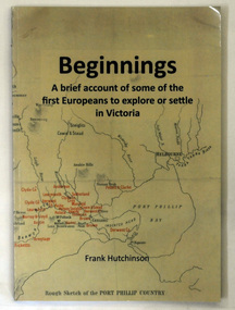
book, Beginnngs, 2011
"A map on the wall of his parent's shop in country Victoria is what got Frank Hutchinson interested in the geography and early settlement of Victoria. He later moved to Ballarat where he spent most of his working life. Whilst there his interest in the early explorers continued until about ten years ago he began to compile the listing which developed into the present publication." (ref.Port Phillip Pioneers Group) When he commenced the research and writing of Beginnings, it was not intended for publication. It was a project of personal interest. A soft covered 122 pp book title Beginnings a brief account of the first Europeans to explore or settle in Victoria. On the glossy front cover is a rough map of Port Phillip Bay. Print is black. a chronological list of the earliest visits to Victoria and attempts to settle. The book contains: brief notes on the exploration and earliest settlement of the state, region by region and a summary of the early Murray River paddle steamer industry.hutchinson-frank history-victoria prahran-mechanics-institute -
 Wodonga & District Historical Society Inc
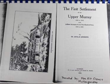
Book - The First Settlement of the Upper Murray 1835 to 1845, Dr. Arthur Andrews, 1920
... A history of settlement on and around the Upper Murray River ...A history of settlement on and around the Upper Murray River, covering the period of 1835 to 1845, including "A short account of over two hundred runs 1835 to 1880". An excellent source of information on the colonial settlement of the Murray River. Detailed information of the first white settlers and the challenges they faced. Interesting account of conflict between settlers and indigenous population. Many indigenous words and their meaning recorded.non-fictionA history of settlement on and around the Upper Murray River, covering the period of 1835 to 1845, including "A short account of over two hundred runs 1835 to 1880". An excellent source of information on the colonial settlement of the Murray River. Detailed information of the first white settlers and the challenges they faced. Interesting account of conflict between settlers and indigenous population. Many indigenous words and their meaning recorded.upper murray district, settlement victoria, colonial settlement, pastoral industry victoria -
 Port of Echuca
Photograph - Black and white photograph, Late 1970s
Relates to a series of 5 photos:P000094-P000098 of the front of the Bridge Hotel on the corner of Murray esplanade and Hopwood gardens. These photos, taken about 1976, were before the Port Restoration Scheme renovated the hotel. The Bridge Hotel was built by Henry Hopwood in 1858. This and the Bond Store were Echuca's first 2 brick buildings. Named from Hopwood's nearby pontoon bridge. The building was bought be The Council in 1970. Restored and reopened in 1975.The Bridge Hotel is an important part of Echuca's settlement and development. It was originally built by Henry Hopwood, the European founder of Echuca, in 1859. Hopwood built the hotel to provide accommodation to people using his punts across the Campaspe and Murray rivers that area central to the landscape of the Port. The hotel was situated on the land between both rivers and punts and provided for a variety of levels of accommodation from grand rooms to very basic rooms. At the time of the photos the hotel was 120 years old and became an important part of the Port of Echuca tourism. Black and white photograph of the Bridge Hotel , showing western wing before restoration.Stamped on the reverse "Gazemore Studio, D. G. Gay, 18 Frances Street Echuca 3625.bridge hotel, echcua, port restoration scheme, bridge hotel restoration, echuca -
 Wodonga & District Historical Society Inc
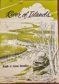
Book - River of Islands, Kath & Leon Bentley, 1985
... Murray River settlement.... Murray River navigation Murray River settlement Leisure ...A detailed guide to the Murray RIver, including descriptions of the terrain and settlements along the river as well as detailed charts of the river from Yarrawonga to the Hume WeirAn A4 sized publication including text, photos and maps describing the history and surrounds of the Murray River from Yarrawonga to the Hume Weir.A detailed guide to the Murray RIver, including descriptions of the terrain and settlements along the river as well as detailed charts of the river from Yarrawonga to the Hume Weirmurray river navigation, murray river settlement, leisure activities - boating