Physical description
Borough Correspondence including: Newspaper Articles 1920 - 1929 and Correspondence 1924 - 1957.
We acknowledge the Traditional Owners of the place now called Victoria, and all First Peoples living and working on this land. We celebrate the history and contemporary creativity of the world’s oldest living culture and pay respect to Elders — past, present and future.
Please be aware that this website may contain culturally sensitive material — images, voices and information provided by now deceased persons. Content also may include images and film of places that may cause sorrow.
Aboriginal and Torres Strait Islander people are advised that this website may contain culturally sensitive material — images, voices and information provided by now deceased persons. Content also may include images and film of places that may cause sorrow.
Some material may contain terms that reflect authors’ views, or those of the period in which the item was written or recorded but may not be considered appropriate today. These views are not necessarily the views of Victorian Collections.
Users of this site should be aware that in many areas of Australia, reproduction of the names and photographs of deceased people is restricted during a period of mourning. The length of this time varies and is determined by the community.
Reuse of any Aboriginal or Torres Strait Islander material on this site may require cultural clearances. Users are advised to contact the source organisation to discuss appropriate reuse.
Borough Correspondence including: Newspaper Articles 1920 - 1929 and Correspondence 1924 - 1957.

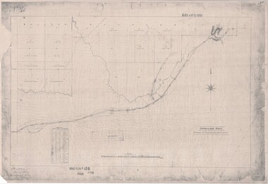
Blueprint copy of Survey Map detailing original Selectors' names and property locations. List of Parish map references including property bearings, distances in Links, and markings on trees. Descriptive remarks include areas marked "Farmer's Common", "Poor soil thickly/moderately timbered with stringy bark", and location of water and firewood reserves.
"Surveyed and plotted by N.M. Bickford, Superintendant of Mr. Hodgkinson's Field Party". "The land comprised in this survey is of inferior quality, moderately undulating, and thickly wooded. It is watered by Dandenong Creek and Deep Creek." Inset map showing location of (*proposed) cemetery on southern corner of Lillydale Road from Melbourne and Sawmill Road, later Mount Dandenong Road. (*Cemetery did not eventuate.)
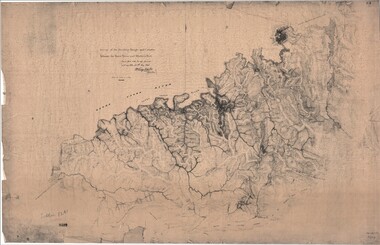
Extract - Ringwood, Place of Many Eagles - Hugh Anderson (1974): William Wedge Darke, from Hereford, England, was a nephew of John Helder Wedge of the Port Phillip Association, who was also a surveyor. William's most important work was probably his survey of the Dividing Range and the country between the Yarra River and Western Port, completed in May 1843, and during which he made a traverse between the Mullum and Dandenong creeks along the higher ground that he labelled the "best line of road from Melbourne". This road was for many years the major route to Gippsland and to the higher country about Alexandra and Mansfield, sometimes known as White Horse Road, and now Maroondah Highway.
Surveyor's relief map of features to the east of Melbourne including Yarra Yarra River, Mullum Mullum Creek, Anderson's Creek, Dandenong Creek.
Transmitted to the Surveyor General with my letter of 10th May 1843 (signed) Wm Wedge Drake, Assistant Surveyor. Scale: two inches to a mile. Descriptive remarks include upstream area of Yarra River - "impassable, appears to have been formerly a lake", and to the south - "barren and scrubby swamps of the Western Port Country". Marked tracks include "best line of road from Melbourne", "track to Dandenong", "Road to Port Albert may probably be found on this range", "Best line to Upper Yarra". Several huts also marked.
`
`
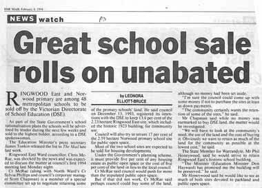
Newspaper clipping from "The Mail", 8-02-1994 P3. NEWS watch. Great school sale rolls on unabated. By LEONORA ELLIOT-BRUCE
Ringwood East and Norwood primary are among 48 metropolitan schools to be sold off by the Victorian Directorate of School Education (DSE). The schools will be advertised by tender during the next few weeks and sold to the highest bidder, according to a DSE spokeswoman. Ringwood East Ward councillor, Chris McCrae, was shocked by the news, and was expected to discuss the matter at council's first 1994 meeting last Monday night.
`
Surveyor's map of the part of the main road from Melbourne to Gippsland following "Barker's Track" south of Mullum Mullum or Deep Creek. Map references include Roman numerals marking distances measured in Links between trees at turns in the road.
Submitted to the Surveyor General (Signed) July 2nd 1855.
`
`
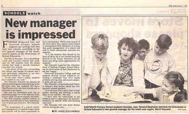
Newspaper clipping from "The Mail", 1-03-1994 P1. SCHOOLS watch. New Manager is impressed. By Jodie Hawthorne
Former Ringwood East and Norwood primary school students are settling well into their new schools, according to the new general manager of the south eastern region of the Directorate of School Education. Mrs Merril Haeusler, who toured Ringwood and Croydon last week, said the 300 students from the closed schools had made a smooth transition into their new schools.
`

Technical drawings of Antimony Mine - Plan view, Transverse Section view, and Longitudinal Section view. Includes Main Shaft, No.1 Level 184', No.2 Level 244', No.3 Level 304', No.4 Level 372'. Multiple copies, including copy with overlay of Civic Centre.
Scale 40 feet to 1 inch. Surveyed 20-12-21. Traced 1-7-66. W-2568/B/1.
`
`
Newspaper clipping from "The Post", 16-10-96 P1
Ringwood North Primary School grade four students tasted success recently in the Royal Melbourne Show "year seven embroidery" competition, with Jana (Front Centre) winning first prize, Felicity (right) second, and Kerryn (left) third.
`

`
`
Newspaper clipping from "The Mail", P8
Ringwood North Primary School has had a big win at the Manningham Eistedfodd recently The 40 strong choir, under the guidance of teacher Pam Peake, and accompanist Marg Baker, won from six schools in the event, held at Bulleen Baptist Chuirch.
`
`
`
Newspaper clipping from "The Mail", 15-9-93, P9 by Jodie Haythorn
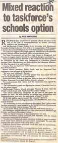
Ringwood East and Norwood primary schools will close at the end of the year if recommendations by quality provision taskforces are implemented.And Marlborough Primary Schoolis set to merge with Heathmont Secondary to form a year prep to 10 campusand a VCE campus at Eastern Secondary College as part of a multi campus disrict facility.
`
`
`
Newspaper clipping from "The Post", 15-9-93, P9
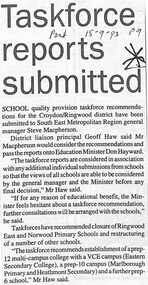
School quality provision taskforce recommendations for the Croydon/Ringwood district have been submitted to South East Metropolitan General Manager Steve Macpherson. District Liaison proncipal Geoff Haw said Mr Macpherson would consider the recommendations and pass the reports onto Education Minister Don Hayward.
`
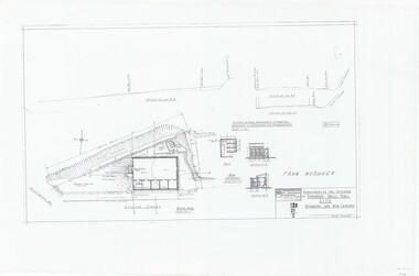
Technical drawings (a) Block Plan - Ringwood Drill Hall Site, Station Street, Ringwood. (b) Plan View, End and Side Elevation, Drill Hall Wodonga - Removed to Ringwood. (c) Plan View, Front and Rear Elevations, Minature Rifle Range at Ringwood Drill Hall.
Commonwealth of Australia. Department of The Interior, Works & Services Branch, Victoria.
`
`
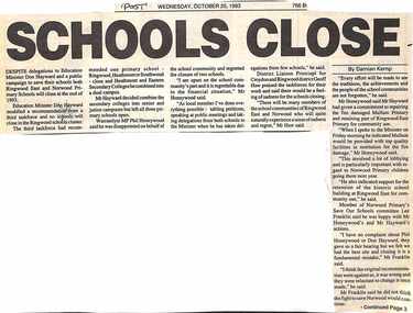
Newspaper clipping from "The Post" Wednesday, October 20, 1993, by Damian Kemp
Despite delegations to Education Minister Don Hayward and a public campaign to save their schools, both Ringwood East and Norwood Primary Schools will close at the end of 1993. Education Minister Don Hayward modified a recommendation from a third taskforce, and no schools will close in the Ringwood schools cluster.
`
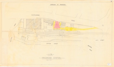
Technical drawing of Ringwood Railway Station features, surrounding streets and buildings including Cool Stores, Packing Shed, Coke Bin, Coal Box, Dam, Garage, Shops, ES&A Bank, Station Master's Residence, Drill Hall, Goods Shed, Signal Box, Passenger Platform, Footbridge, and Clock Tower at Warrandyte Road. Station entrance and traffic access areas shaded red and yellow.
Scale: 1"=40'
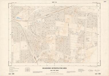
Map prepared by Dept of Lands and Survey and MMBW from State Aerial Survey December 1956 and Cadastral Survey information December 1962. This sheet comprises parts of the Municipalities of Croydon, Ferntree Gully, and Ringwood, and Parishes of Ringwood and Scoresby.
Scale: 400 feet to 1 inch. Contours at 5 feet vertical interval. By Authority: A.C. Brooks, Commonwealth Printer, Melbourne.
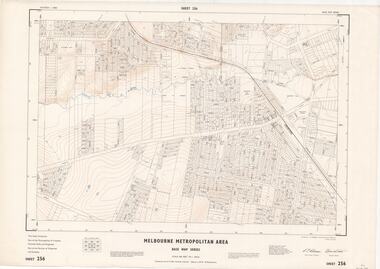
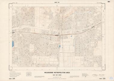
Map prepared by Dept of Lands and Survey and MMBW from State Aerial Survey December 1956 and Cadastral Survey information May 1963. This sheet comprises parts of the Municipalities of Ferntree Gully, Nunawading and Ringwood, and Parishes of Nunawading, Ringwood and Scoresby.
Scale: 400 feet to 1 inch. Contours at 5 feet vertical interval. By Authority: A.C. Brooks, Commonwealth Printer, Melbourne.
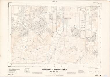
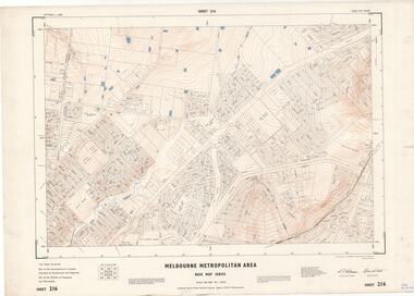
Map prepared by Dept of Lands and Survey and MMBW from State Aerial Survey June 1957 and Cadastral Survey information May 1961. This sheet comprises parts of the Municipalities of Croydon and Ringwood, and Parishes of Ringwood and Warrandyte.
Scale: 400 feet to 1 inch. Contours at 5 feet vertical interval. By Authority: A.C. Brooks, Commonwealth Printer, Melbourne.
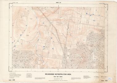
Map prepared by Dept of Lands and Survey and MMBW from State Aerial Survey June 1957 and Cadastral Survey information August 1960. This sheet comprises parts of Municipalities of Doncaster & Templestowe, Nunawading and Ringwood, and Parishes of Nunawading, Ringwood and Warrandyte.
Scale: 400 feet to 1 inch. Contours at 5 feet vertical interval. By Authority: A.C. Brooks, Commonwealth Printer, Melbourne.
Map prepared by Dept of Lands and Survey and MMBW from State Aerial Survey June 1957 and Cadastral Survey information July 1967. This sheet comprises parts of Municipalities of Croydon, Doncaster & Templestowe, and Ringwood, and Parishes of Ringwood and Warrandyte.
Scale: 400 feet to 1 inch. Contours at 5 feet vertical interval. By Authority: A.C. Brooks, Commonwealth Printer, Melbourne.
Map prepared by Dept of Lands and Survey and MMBW from State Aerial Survey June 1957 and Cadastral Survey information July 1967. This sheet comprises parts of Municipalities of Doncaster & Templestowe, Nunawading and Ringwood, and Parishes of Nunawading and Warrandyte.
Scale: 400 feet to 1 inch. Contours at 5 feet vertical interval. By Authority: A.C. Brooks, Commonwealth Printer, Melbourne.
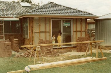
Near the corner of Cormistom Road and Florence Avenue onto Oban Road. The house is still there today (2024).
Taken by Roy J Mitchell
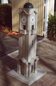
Used for fund-raising by inserting money in the slit on the model
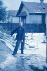
Clarrie Burns, father of Neville, shovelling hail stones from his driveway at 13 Warrandyte Road, Ringwood in the late 1950s. Clarrie worked for Ringwood City Council as Superintendent of Works. In the image, number 11 Warrandyte Road was Sherman's house, number 9 the Haywards, then (hidden) the Salvation Army citadel.
A0-size (approx) City Engineer's map with hand-drawn overlay highlighting natural water-courses in the Ringwood area, as identified by Rob Atkins, former RDHS President. Other pencilled markings include Perry's Hut, Jull's Store, Crawley's Hut.
Scale: 8 chains to 1 inch.
`
`
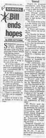
Newspaper clipping from "The Mail" October 26, 1993. School bill ends hopes. By Jodie Haythorne
Sweeping education reforms introduced to State Parliament last week could stop Ringwood East Primary School from fighting closure.
`
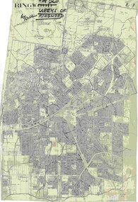
A0-size (approx) map of named streets, lot-numbered properties and locality features within City of Ringwood boundary.
Scale: 8 chains to 1 inch. City Engineer's signature in bottom right corner - Alan Robertson (City Engineer 1958-1987)
`
`
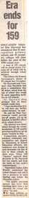
Newspaper clipping from 1993. Era ends for 159. By State political reporter JANE SCHULZE
Education Minister Don Hayward has announced that 52 metropolitan primary schools ansd 10 secondary colleges will close befoere the start of the 1994 school year.A total of 159 schools will be closed across Victoria, 59 of which will be achieved through school mergers. The Opposition leader John Brumby condemned the school closures and said it was a precursor to more funding cuts within the education system. "The quality provision process has never been anything more than a euphemism for school closures" he said.
`
`
`
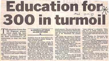
Newspaper clipping from the "Mail" 19-10-93 P1. Education for 300 in turmoil, by Leonara Elliot-Bruce and Jodie Haythorne
The education of more than 300 Ringwood Primary School pupils has been thrown into turmoil following the State Government's announcement to close two local schools.Ringwood East and Norwood primary schools were told last Friday they would close at the end of the year. The principals are not happy.
`
`
`
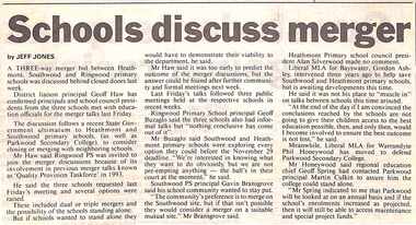
Newspaper clipping from the "Mail" 19-11-96 P7. Schools discuss merger, by Jeff Jones
A three way merger bid by Heathmont, Southwood and Ringwood Primary schools was discussed behind closed doors last week
`
`
`
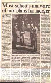
Newspaper clipping from the "Mail" 5-11-96 P9. Most schools unaware of any plans for merger.
Wih the State Government's position well known on school mergers, "The Mail" surveyed Maroondah's schools on the same subject. Most of the surveyed schools said they knew nothing of any planned mergers, or they did not wish to comment. No school said they were in favour of mergers in Maroondah.
`
`
`
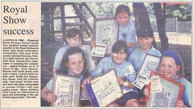
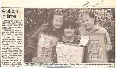
Newspaper clipping from the "Mail" 22-10-96 P5. A stitch in time. L to R : Kerryn, Jana and Felicity
Grade 4 students at Ringwood North Primary School have won the top prizes in a Royal Mellbourne Show embroidery competition. In all, seven students won prizes at the show.
`
Victorian Collections acknowledges the Australian Aboriginal and Torres Strait Islander peoples as the first inhabitants of the nation and the traditional custodians of the lands where we live, learn and work.