-
 Bendigo Military Museum
Administrative record - Army Survey Regiment - Malee Country Project 4 Mar - 26 May 1987, Army Survey Regiment, Bendigo, 30 Jun 1987
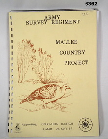
Project Mallee Country was support provided to Operation Raleigh by members of the Army Survey Regiment during the period 4 Mar - 26 May 1987. This is the report on their activities. Colonel John Blashford-Snell and Prince Charles launched Operation Drake in 1978, running youth projects from ships circumnavigating the globe, to develop self-confidence and leadership through adventure, scientific exploration and community service. In two years 414 young people took part in the round the world voyage, working on land-based projects in 16 countries. Following the success of Operation Drake, the much more ambitious Operation Raleigh was established in 1984, and ran for five years until 1989. The success of Operation Raleigh saw it continue on a permanent basis in 1988, with an emphasis on land-based expeditions.A4 Report, beige coloured cover, brown motif of Mallee Fowl, containing typed paper pages, poor quality photocopied photos and diagrams, unbound.royal australian survey corps, rasvy, fortuna, army survey regiment, army svy regt, asr -
 Stawell Historical Society Inc
Archive, Education Department of Victoria, Concongella State School No 1136 Inspectors Report 1872-1878, 1872
Donated from Back to Concongella CommitteeLarge Black Plastic Folder with clear pocketsInspectors Register Book Common Schoolseducation -
Stawell Historical Society Inc
Map, Easton Johnstone, Map of Stawell Surveyed by Easton Johnstone 1872, 1872
Victoria Co Crushing Machine. St Georges Co Crushing machine. Wimmera Co Crushing Machine. Government Reservoir and Drainage. Sloan Street, Skene Street Mines. old Mine WorkingsA2 map of Stawell Reefs Area. Showing Crushing Machines & Title InfoSurveyed by Easton Johnstone Contract Surveyor. Photo-Lithographed at the Department of Lands & Survey. Melbourne By J Noone 9th May 1872mining -
 Bendigo Historical Society Inc.
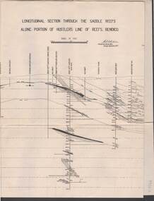
Map - STRUGNELL COLLECTION: HUSTLER'S LINE OF REEF, September 1913
Map, Longitudinal section through the Saddle Reefs along portion of Hustler's Line of Reefs, Bendigo. Plate No. XXX1V(34). Underground Survey Office,Bendigo, September 1913. Geological Society of Victoria.//Signed H.A.Whitelaw. Drawing shows the vertical shaft descending to over 3454 ftUnderground Survey Office, Bendigomap, bendigo, hustler's line of reefs -
 Kew Historical Society Inc
Plan, J R Mathers & McMillan, 5 Splendid vVlla Allotments,: Segtoune St. & Windsor St., Kew, 1928
Prue Sanderson, in her groundbreaking ‘City of Kew Urban Conservation Study : Volume 2 - Development History’ (1988), summarised the periods of urban development and subdivisions of land in Kew. The periods that she identified included 1845-1880, 1880-1893, 1893-1921, 1921-1933, 1933-1943, and Post-War Development. These periods were selected as they represented periods of rapid growth or decline in urban development. An obvious starting point for Sanderson’s groupings involved population growth and the associated economic cycles. These cycles also highlighted urban expansion onto land that was predominantly rural, although in other cases it represented the decline and breakup of large estates. A number of the plans in the Kew Historical Society’s collection can also be found in other collections, such as those of the State Library of Victoria and the Boroondara Library Service. A number are however unique to the collection.Subdivision plans are historically important documents used as evidence of the growth of suburbs in Australia. They frequently provide information about when the land was sold on which a built structure was subsequently constructed as well as evidence relating to surveyors and real estate and financial agents. The numerous subdivision plans in the Kew Historical Society's collection represent working documents, ranging from the initial sketches made in planning a subdivision to printed plans on which auctioneers or agents listed the prices for which individual lots were sold. In a number of cases, the reverse of a subdivision plan in the collection includes a photograph of a house that was also for sale by the agent. These photographs provide significant heritage information relating house design and decoration, fencing and household gardens.In 1928, five residential allotments bordering Segtoune and Windsor Streets were advertised for sale as part of a subdivision. Four of the blocks faced Segtoune Avenue. The auctioneers proclaimed the advantages of the sites: ‘Situate one minute from the High Street Electric Tram, which now runs direct to Spencer Street via Bridge Road and Flinders Street. Opposite the East Kew Railway Station (Outer Circle Line), which may be reopened In connection with the new Line from Kew to Doncaster; Adjacent lo the Kew Recreation Reserve, Sports Oval, and Swimming Bath; Half Minute from the Shopping Centre of East Kew, Accessible to the State School and Other Educational Centres’. The Harp of Erin Hotel and the route of the Outer Circle Railway line are marked on the plan. The Recreation Reserve and Sport Oval refer to Victoria Park. The Swimming Baths were located on the site of the current Kew Recreation Centre.subdivision plans - kew, segtoune street -- kew (vic.), windsor street -- kew (vic.) -
Whitehorse Historical Society Inc.
Map, Bruce, 1989
Map of the Commonwealth Electoral Division of BruceMap of the Commonwealth Electoral Division of BruceMap of the Commonwealth Electoral Division of Bruceelectoral boundaries, bruce (commonwealth electoral division) -
Whitehorse Historical Society Inc.
Map, The Parish of Nunawading, 1853
Photocopy of manuscript plan with allotments numbered and some named.Photocopy of manuscript plan with allotments numbered and some named. Note on verso: The Parish of Nunawading in the County of Bourke; lithographed at the Surveyor General's office by J.Jones Jan 18th 1853. Endorsed Sale Plan 271. Dray tracks, water holes and terrain indicated.Photocopy of manuscript plan with allotments numbered and some named. land subdivision, maps, parish of nunawading, jones, j -
Lakes Entrance Regional Historical Society (operating as Lakes Entrance History Centre & Museum)
Administrative Record - Ledger, Minute Book, 22221
Entries are hand written in ink, book is filled to capacity, bound with cardboard cover.A minute book containing minutes iof meeting of Loyal Mitchell Lodge of Manchester Unity Independent Order of Oddfellows (MUIOOF) meetings.minute book -
Port Melbourne Historical & Preservation Society
Archive - What Port means to me, 1990 - 1991
File 05 - submissions on what Port means to me, records of interviews and tape detailslocal government - city of port melbourne, built environment, families, celebrations fetes and exhibitions, domestic life, industry, recreation, sport, pat grainger, jill dawson, wendy morris, vintage port - worth preserving project 1991 -
Kew Historical Society Inc
Archive (series) - Subject File, Alexandra Gardens, Kew (Vic), 1958
Various PartiesReference, Research, InformationKHS OrderReference file containing information about the Alexandra Gardens in Cotham Road (Kew) including: collected notes including brief histories by Gwen McWilliam, John Patrick, Dorothy Benyei, and Mavis Rolley. There is also an article on the Garden’s designers, the Pockett Brothers, originally published in 2015 in Australian Garden History. The archive file also includes Council publications, posters (relating to the Mimovich sculptures), correspondence (including photocopies of a letter relating to historic plantings from Jack Higgins) and newspaper articles/clippings. In addition to general historical notes, the file includes specific notes on the Rotunda and on historic trees in the Gardens. The original by-laws of the Gardens, printed on cotton are held separately in the textiles collection.alexandra gardens - kew (vic.), parks and gardens - city of boroondara, madford, pockettalexandra gardens - kew (vic.), parks and gardens - city of boroondara, madford, pockett -
 Kew Historical Society Inc
Plan - Subdivision Plan, Jaques Estate, 1927
The Kew Historical Society collection includes almost 100 subdivision plans pertaining to suburbs of the City of Melbourne. Most of these are of Kew, Kew East or Studley Park, although a smaller number are plans of Camberwell, Deepdene, Balwyn and Hawthorn. It is believed that the majority of the plans were gifted to the Society by persons connected with the real estate firm - J. R. Mathers and McMillan, 136 Cotham Road, Kew. The Plans in the collection are rarely in pristine form, being working plans on which the agent would write notes and record lots sold and the prices of these. The subdivision plans are historically significant examples of the growth of urban Melbourne from the beginning of the 20th Century up until the 1980s. A number of the plans are double-sided and often include a photograph on the reverse. A number of the latter are by noted photographers such as J.E. Barnes.The Jaques Estate was a small subdivision of eight residential allotments bordering Jaques Street and Barkers Road in what is now Hawthorn East. Advertised in The Argus as being in ‘Upper Hawthorn’ the subdivision was claimed to include: ‘charming villa sites in excellent situations, with every convenience available, and with superior homes surrounding’.subdivision plans - hawthorn, jaques estate -
Bendigo Historical Society Inc.
Map - CAMPBELL COLLECTION: BENDIGO AND DISTRICT MAPS, 18-6 29
Map. Longlea, Parishes of Axedale and Eppalock, scale 20 chains to 1 inch, total area 2372 acres. Prepared from Assessment Plan and Parish Plan by H.A. Darby18-6-29., Wondong, Heathcote and Sandhurst line (Railway). (number 386 in map cupboard 1)H.A.Darbymap, bendigo, agricultural lands -
Kew Historical Society Inc
Archive (Series) - Recycling [Kew]
Various PartiesReference, Research, InformationArranged by Secondary Values (value of records to users)Kew’s modern recycling program began in 1991 and continues to this day. The file includes: A booklet documenting the trial of recycling in 1991 that provides information about the program, and a newspaper article regarding the new program.recycling – kew (vic.), council services – kew (vic.)recycling – kew (vic.), council services – kew (vic.) -
Federation University Historical Collection
Map, Aboriginal Language Areas in Victoria: A Reconstruction
A4 sized map of Victoria showing Aboriginal Langauge Areas. Black, white and red writing aboriginal, aboriginal language, victoria, djadja wurrung, woi wurrung, watha wurrung, gadubanud, girai wurrung, dhauwurd wurrung, djab wurrung, wiradjuri, tatungalung, wadiwadi, dadidadi, yuyu -
 Bendigo Historical Society Inc.
Administrative record - Land Sales Register
Large cloth bound ledger, hard board cover, front and back. Over a hundred pages not all numbered. Handwritten. Dates from 1906 - 1922. ledger filled with names, addresses, financial details, and glued in posters of land sales associated with clients. Castlemaine is listed as the area for the ledger and also St Anaud, Maryborough, Avoca, Inglewood, Dunolly, Daylesford, Maldon, Heathcote, Woodend. Scratched on the front cover is a faded reading of 'Castlemaine.' Written onto the spine is written in blue texta, 'Land Sales, C'Maine,' and also '8.6.1906 to 23.2.1922.' land sales, register, castlemaine -
 Melton City Libraries
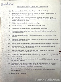
Archive, Melton Fire Brigade Ladies Aux Constitution, Unknown
Edna Barrie was a member of the Melton Fire Brigade Ladies Auxiliary from its inception in 1968, a non-operational positionEdna Barrie's copy of Melton Fire Brigade Ladies Aux Constitution and list of membersemergency services, local identities -
 Kew Historical Society Inc
Plan, F R Simms & Son, Land for Private Sale: Cnr Victor Avenue and Mont Victor Road, Kew, 1950-1960
George Rimington established The Parkhill Nursery in 1877. By 1910, it was more commonly known as Rimington’s Nurseries and well known for its sale of violets. After World War II, Rimington’s Nurseries were gradually subdivided and sold. The 38 allotments were released in sections, including lots 34 to 36 on the corner of Mont Victor Road and Victor Avenue. Previous lots in the subdivision had bordered Burke Road, Rimington Avenue, Heather Grove, and Stoke Avenue. The selling point as it had been in comparable estates for a century were the proximity to transport, schools and churches, as well as the high location and excellent views. The subdivision plan shows most of the lots in the entire subdivision: 1-11, 13-26, and 34-38. Presumably, lot 12 and lots 27-33 were still to be released.Subdivision plans are historically important documents used as evidence of the growth of suburbs in Australia. They frequently provide information about when the land was sold on which a built structure was subsequently constructed as well as evidence relating to surveyors and real estate and financial agents. The numerous subdivision plans in the Kew Historical Society's collection represent working documents, ranging from the initial sketches made in planning a subdivision to printed plans on which auctioneers or agents listed the prices for which individual lots were sold. In a number of cases, the reverse of a subdivision plan in the collection includes a photograph of a house that was also for sale by the agent. These photographs provide significant heritage information relating house design and decoration, fencing and household gardens.Subdivision plan advertising five superb home sites among lots in Burke Road, Stoke Avenue, Victor Avenue, Mont Victor Road and Heather Grove.subdivision plans - kew, rimington avenue -- kew (vic.), heather grove -- kew (vic), stoke avenue -- kew (vic.), burke road -- kew (vic.), mont victor road -- kew (vic.) -
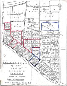 Ringwood and District Historical Society
Map, The East Estate, Township of Ringwood, Victoria - 1927
Photocopied page - partial Parish map of Ringwood labeled The East Estate, showing street names and properties marked with names of individual owners or businesses.Page titled The East Estate by 1927 Part of Township of Ringwood, Parish of Ringwood, County of Mornington, Scale: Four Chains to One Inch. L.F. East blocks are marked by red outline. J. Blood blocks are marked by blue outline. Other names include B.C. Hutchinson & Co., The Victorian Brick & Ornamental Tile Coy., Ltd., The Ringwood Brickmaking Coy., Ltd., R. Davidson, J. Williamson, W.E. Bower, H. Jennings, G.J. Sims, J. Smallman, J. Horne, J. Lindsay, J. Kay, H. Unverhan, B.C. Hutchinson, M.A. Williamson, J.S. Woodworth, J. Price, C. Medew, S.W. Burchett, B.J. Hosking, D.J. Rogers, C. Wheeler, H. Frost, G.G. Miller, L. Winchcombe. Streets include Dublin Road, Illoura Road, Alexandra Road, and Bedford Road. -
University of Melbourne, Burnley Campus Archives
Plan, Egg Laying Competition
Copy of plan for fencing. Area bounded by potting sheds, vehicle park, tennis court and railway line.fencing, tennis court, vehicle park, egg laying, competition -
Clunes Museum
Map, 1962
.1 &.2 MAP OF BALLARAT SHIRE GROUP RURAL FIRE BRIGADES FIRE CONTROL MAP. COMPILED BY C. H. FENTON. (2 COPIES) DETAILING SEALED ROADS, STATE FORESTS, PINE PLANTATIONS, FOREST AREAS, RAILWAYS, BOUNDARIES, TOWNSHIP AREAS CEMETERIES, CREEKS, SWAMPS AND HOUSES.local history, document, maps, fire brigade -
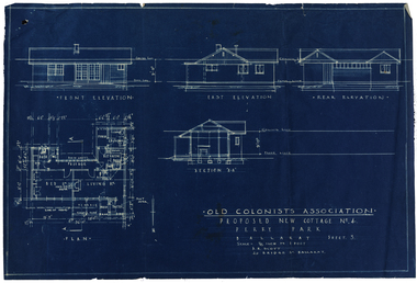 Old Colonists' Association of Ballarat Inc.
Plan, Old Colonists' Association Proposed New Cottages No. 4, Sheet 5, c1925
Blueline plan of the Old Colonists' Association. old colonists' association ballarat, charles anderson grove, retirement village, old colonists' association ballarat cottages -
Glenelg Shire Council Cultural Collection
Plan - Ship Plan / Mould, n.d
Wooden pattern for mould for boat fitting. Cylinder, made in 2 halves, joined with wooden dowels. Round knob attached to either end. Painted green. -
Stawell Historical Society Inc
Map - Drawings, Wendy Jacobs, Western Highway Community Precinct Development Structural Drawings, 2014
501 Slab and Footing Plan. 502 Slab and Footing Details. 505 Roof Framing Plan 506 Steel Framing Elevations - Sheet 1. 507 Steel Framing Elevations and Sections - Sheet 2 508 Steel Framing Details - Sheet 1 509 Steel Framing Details - Sheet 2 SN1 General Notes, Site map & Drawing Index Used in building Historical Society Building Eight (8) A1 Printed plans Structural DrwaingsWendy Jacobs Architect & Heritage consultant may 2014 -
 Federation University Historical Collection
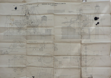
Plan, Chiltern Valley Gold Mines Co Ltd, Poppet Head drawings, not dated
Ink on paper drawings of Poppet Head.chiltern valley, chiltern valley gold mines co ltd, poppet head, drawing, mining -
 Federation University Historical Collection
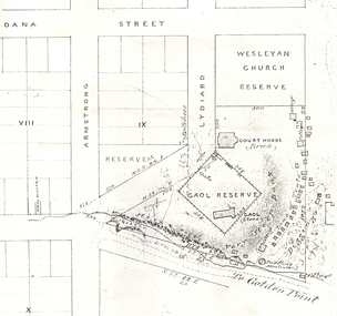
Plan, Ballarat Showing Gaol Reserve, 1857, c1857
The portion of Lydiard Street depicted on this plan is now part of the Federation University Ballarat School of Mines (SMB) campus.Copy of an early plan of the former Ballarat Gaol Site.ballarat, ballarat gaol, ballarat gaol reserve, gaol reserve, ballarat courthouse, plan, gold diggings, smb campus, lydiard street south -
Port Melbourne Historical & Preservation Society
Archive - File, Port Melbourne Leading Lights, c. 1995
Found in Pat Grainger's archivesFile of photocopies prepared for Angela Wallace in the early days of the City of Port Phillip, as reference for commissioning public art installation re the Leading Lights - - extracts from heritage study done about 1990 ;letter to Angela;piers and wharves, leading lights, arts and entertainment, beacons, angela wallace, leading lights -
 Kew Historical Society Inc
Plan - Subdivision Plan, Balwyn Theatre and Shop Sites, circa 1927-28, c.1927-28
The Kew Historical Society's map collection includes a substantial number of real estate subdivision plans, mainly of Kew but also of surrounding suburbs in Melbourne. Most of the subdivision plans date from the 1920s and 1930s when the districts old homes and local farmland were being split up to accommodate residential growth in the postwar period. These early plans were assembled by a local firm, Jas R Mather & McMillan, which had an office in Cotham Road. Many of the plans, and sometimes photos, were annotated by the agents. The ‘new’ Balwyn Picture Theatre was built and owned by Balwyn Theatres Pty Ltd in ca. 1928. By 1930, this first Balwyn Theatre was destroyed by fire after a break-in. Following the fire, a new cinema was constructed. This plan for a Cinema and eleven shops presumably dates from 1927/28 when the Company announced that this location in Whitehorse Road ‘was the most central and best suited [area] for their Theatre and shops’.Subdivision plans are historically important documents used as evidence for the growth of suburbs in Australia. They frequently provide information about when the land was sold as well as evidence relating to surveyors and real estate and financial agents. The numerous subdivision plans in the Kew Historical Society's collection represent working documents, ranging from the initial sketches made in planning a subdivision to printed plans on which auctioneers or agents listed the prices for which individual lots were sold. In a number of cases, the reverse of a subdivision plan in the collection includes a photograph of a house that was also for sale by the agent. These photographs provide significant heritage information relating house design and decoration, fencing and household gardens.The photograph may also be aesthetically significant depending on the importance of the photographic atelier.Subdivision plan showing the Balwyn Theatre and its adjoining shop sites in Whitehorse Road Balwyn. The 11 shop sites were noted for their depth (133 ft - 145 ft. [Map.0041]balwyn theatre -- balwyn (vic.), subdivisions -- balwyn (vic), subdivision plans -
National Vietnam Veterans Museum (NVVM)
Journal, Hats Journal: helping all that served
australia – history, military – periodicals -
 Heidelberg Golf Club
Administrative record - Minute Book, Heidelberg Golf Club, Ladies'/Associates' Committee Minutes: Book L/A 20: February 2013 - December 2013, 2013
Typed minutes of Committee Meetings of the Lady members of Heidelberg Golf Club 2013. Note the change of name from "Lady members" to "Women members" in 2014.Volume 20 of a complete set of Associates' minutes from the foundation of HGC to the present day.Multiple pages, typed, in black plastic spiral binder book.committee minutes, women's golf, associates, ladies' golf -
 Peterborough History Group
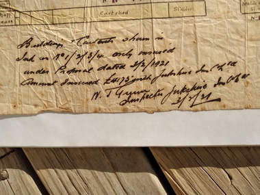
Map - Map of Peterborough House 1921, 1921
This hand drawn map of the buildings and out buildings was done for insurance purposes. It indicates which buildings are covered and which are uninsured. Significant as it shows a plan of the hotel as it was in 1921. Each building is labelled by its purpose, which provides an interesting insight into holidays of the time. For example, 'sleep outs' and external bathrooms. A4 photocopy of a hand drawn map of the buildings and out buildings comprising Peterborough House. Hand drawn map