-
 Port Melbourne Historical & Preservation Society
Archive - Alan Mathews and family
The Mathews family have been in continuous ownership of 395 Howe Parade (was 8 Howe Parade until 1964 when addresses re-assigned), Port Melbourne from 1938 to the present (Sept 2019)Six folders of assorted documents relating to the life of Alan Mathews and his family. Collected items, paper notes, drawings from Alan's childhood. Folder for photos: T Griffin Pharmaciesdomestic life, alan mathews -
University of Melbourne, Burnley Campus Archives
Administrative record, Repairs to Floor in Library, 2018
repairs, library, superintendent of agricultural education, t h kneen, principal, administration -
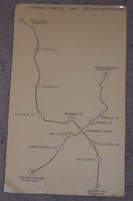 Ballarat Tramway Museum
Map, "Bendigo Tramway Routes and Section Destinations", c1970
Demonstrates the layout of the Bendigo tramways, extracted from the Fare Schedule. Basis of production, source unknown. Associated with Eildon Hogan.Plastic coated, card mounted map showing diagrammatic routes of map of Bendigo routes, extracted from the SEC Fare Schedule.trams, tramways, bendigo, map -
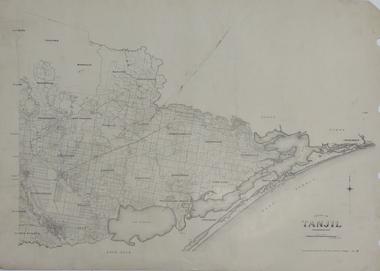 Federation University Historical Collection
Map, County of Tanjil, 23/11/1906
Printed map on papertanjil -
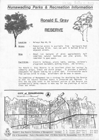 Whitehorse Historical Society Inc.
Map, Ronald E. Gray Reserve, n.d
Strategy of Committee of Management for development of reserve including planting of native trees and shrubs.parks and reserves, outlook drive, nunawading, springvale road, ashwood drive, olwen street, tatman, r. r, louden, j. b., gray, ronald e, r. e. gray reserve -
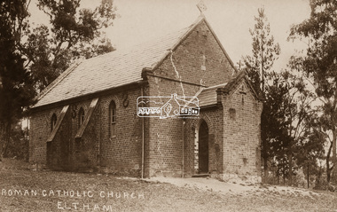 Eltham District Historical Society Inc
Negative - Photograph, St Mary's Roman Catholic Church, Eltham, c.1910
Note the extensive cracking of the mortar and bricks in the front facade near the portico entrance. The original St Mary’s Roman Catholic Church (1865-1912) was built of clay brick with buttress walls and a slate roof on the corner of Fordhams Road and Maria Street (Main Road), Eltham South, opposite the present-day Wingrove Park. It was blessed on September 3, 1865. With the arrival of the railway in 1901 and the town centre moving closer to the station, the decision was made to relocate the site of the church to its present-day location on Henry Street at the corner of Main Road. A new timber weatherboard church, also called St Mary's was erected and blessed on October 13, 1912. The church and land cost £1,400 (Evelyn Observer). The original brick church It was demolished in the 1920s and the bricks and windows were recycled to build a dairy on the Brinkkotter farm at Research. The timber church was destroyed by fire in 1961 and a new modern architectural (1960s) style church was erected in its place and named Our Lady of Help Christians Church.This photo forms part of a collection of photographs gathered by the Shire of Eltham for their centenary project book,"Pioneers and Painters: 100 years of the Shire of Eltham" by Alan Marshall (1971). The collection of over 500 images is held in partnership between Eltham District Historical Society and Yarra Plenty Regional Library (Eltham Library) and is now formally known as the 'The Shire of Eltham Pioneers Photograph Collection.' It is significant in being the first community sourced collection representing the places and people of the Shire's first one hundred years.Digital image 4 x 5 inch B&W Neg Sepia postcardsepp, shire of eltham pioneers photograph collection, eltham, roman catholic church, church, catholic church, main road, st marys catholic church -
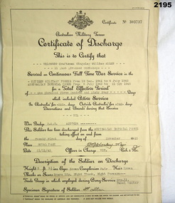 Bendigo Military Museum
Administrative record - DISCHARGE CERTIFICATE, 21.11.45
K.W Allen VX109839 2nd AIF. Refer 2192.4, 2193, 2196P. Certificate of Discharge re VX109839 K.W Allen, certificate No 303737, yellowed parchment paper, black printed form with spaces to type in individual details. Form details name, rank, Regt No, enlistment and discharge dates, service in and outside of Australia, signed by Officer in charge at date of discharge. documents, military, service -
Bendigo Historical Society Inc.
Map - CAMPBELL COLLECTION: BENDIGO AND DISTRICT MAPS
Map. Ascot, Parishes of Huntly, Sandhurst and Wellsford. Scale 20 chains to 1 inch. Total area 2818 acres. To Bendigo 4 1/2 miles, to Epsom 3/4 mile, Huntly 3/4 mile. Prepared in W.P.B. from Assessment Plans and Parish Plans. (number 380 in map cupboard 1)map, bendigo, agricultural lands -
Moorabbin Air Museum
Archive (Item) - Box Baa 61 Boeing (Gaf / Asta) Collection
Description: - JINDIVIK DRAWINGS B4A-A12-001 TO B4A-A20-116/117 Level of Importance: National. Historical Details: DAP/GAF/ASTA constructed many overseas designs under licence in Australia (Beaufort, Beaufighter, Lincoln, Canberra and F18) however they also designed and constructed a number of significant local designs that were successful in oversea's markets includi -
University of Melbourne, Burnley Campus Archives
Journal, Cultivating the Global Garden, 1998-1999
horticulture -
Whitehorse Historical Society Inc.
Map, Railway map of Victoria, 1912
Detailed map of railways in Victoria including adjacent areas of New South Wales.Detailed map of railways in Victoria including adjacent areas of New South Wales. Also shows 'principal coach routes'. On verso map of suburban lines with eastern line as far as Croydon and Bayswater. key numbers on map linked to pages of a timetable.Detailed map of railways in Victoria including adjacent areas of New South Wales.maps, railways -
Port Melbourne Historical & Preservation Society
Archive - Alan Mathews and family, 28 Feb 1949
The Mathews family have been in continuous ownership of 395 Howe Parade (was 8 Howe Parade until 1964 when addresses re-assigned), Port Melbourne from 1938 to the present (Sept 2019)Six folders of assorted documents relating to the life of Alan Mathews and his family. Details of insurances and purchases Contract from Industrial Acceptance Corporation Ltd and James Edward Mathews purchase of Demcrat Portable Radiogramdomestic life, alan mathews, j e mathews -
Moorabbin Air Museum
Archive (Item) - Box Baa 104 Boeing (Gaf / Asta) Collection
Description: - JINDIVIK TRIAL DATA File labelled “Historical Use” - Correspondence between Senior Representative , Dept of Supply, Australia House, London and GAF 02/01/1974 to 30/12/1975 Jindivik - Trailing Edge Pressures - Trials Jindivik 2B Trials - Level of Importance: National. Historical Details: DAP/GAF/ASTA constructed many overseas designs under licence in Australia (Beaufort, Beaufighter, Lincoln, Canberra and F18) however they also designed and constructed a number of significant local designs that were successful in oversea's markets includiCAC -
Bendigo Historical Society Inc.
Map - CITY OF BENDIGO STREET AND ROAD MAP, 1946
Map: City of Bendigo Street and road map, Incorporating the Borough of Eaglehawk and surrounding Districts. Compiled by W.C Harrymap, bendigo, city streets, bendigo streets -
 Bendigo Historical Society Inc.
Map - JACK FLYNN COLLECTION: HUNTLY, 12.03.1932
Map: Township of Huntly, Parish of Huntly , County of Bendigo. Parish plan. Western and South Riding Division on Main St. (Main Northern Highway) - written in ink below name of map.BY Authority H.J. Green. Photo-Lithographed at the Dept., of Lands and Survey, Melbourne. 12.3.32map, bendigo, township, huntly -
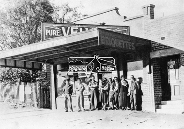 Eltham District Historical Society Inc
Negative - Photograph, Burgoyne family outside J.N. Burgoyne's Store, Main Road, Eltham, Vic, 1940
The store built in 1925 was located on Main Road just south of Bridge Street (present day No. 820 Main Road). An extension was added to the right in 1939. The store was built in late 1925 at the same time as Mr C. Nicholls’s new store was constructed. Both were considered modern shops, and an improvement on most, business establishments of the time. Mr. Nicholls’s store included alongside it a modern, weatherboard villa residence. Mr. Burgoyne’s store incorporated the post and telegraph office, which was operated by John Neville Burgoyne’s half-aunt, Miss Anne Hunniford until her death in 1928 at which time J.N. Burgoyne became postmaster. The unsealed footpath in front is reasonably extensive as not visible is a concrete kerb and channel which was laid from the Post Office to John Street during Nov-Dec 1926. Footpath construction in front of Burgoyne’s store commenced August 1942. The extension to the right of the store was erected in 1939 for a new telephone exchange adjacent to the store and post office. A continuous telephone service operated by Mr Burgoyne and his family commenced operation 18 November 1939. Approximately 70 extensions were routed through the new exchange, 40 of which were transferred from the Greensborough Exchange. Entry to the exchange was via a separate door on Main Road or via the shop. The public telephone was initially mounted on the wall but later moved to the street. Cross Ref: 0701 of the store c.1934This photo forms part of a collection of photographs gathered by the Shire of Eltham for their centenary project book,"Pioneers and Painters: 100 years of the Shire of Eltham" by Alan Marshall (1971). The collection of over 500 images is held in partnership between Eltham District Historical Society and Yarra Plenty Regional Library (Eltham Library) and is now formally known as the 'The Shire of Eltham Pioneers Photograph Collection.' It is significant in being the first community sourced collection representing the places and people of the Shire's first one hundred years.Digital image 4 x 5 inch B&W Negshire of eltham pioneers photograph collection, burgoyne's shop, eltham, main road, post office, shops -
Bendigo Historical Society Inc.
Map - LOCAL AREA PLANS, See above
Map: Compilation of maps: Town lots Bridgewater dated April 29 1871. Village of Colbinnabbin, dated 5 December 1866, Township of Axedale 1858 (Larritt). Suburban lands Axedale dated April 12 1871map, bendigo, parish plan, bridgewater, colbinnabbin, axedale, suburban lands -
Bendigo Historical Society Inc.
Map - SANDHURST SHEET 1, 27/05/1925
Map: Sandhurst ,County of Bendigo, sheet 1. Parish planmap, bendigo, parish plan, sandhurst -
Port Melbourne Historical & Preservation Society
Archive - Alan Mathews and family, 12 Sep 1950
The Mathews family have been in continuous ownership of 395 Howe Parade (was 8 Howe Parade until 1964 when addresses re-assigned), Port Melbourne from 1938 to the present (Sept 2019)Six folders of assorted documents relating to the life of Alan Mathews and his family. Employment documents Apprenticeship Commission of Victoria. Certificate of Proficiency Jobbing and Moulding & Core making. Alan Mathews completion 13/6/1949education - other, alan mathews -
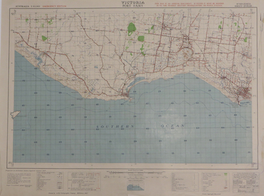 Federation University Historical Collection
Map, Port Fairy, 1942
Printed colour mapport fairy, tower hill, killarney, armstrong bay, crossley, southern cross, kirkstall -
Bendigo Historical Society Inc.
Map - DIGGORRA : COUNTY OF BENDIGO, 26-6-36
Map. Parish of Diggorra, County of Bendigo, Parish of Ballendella, Parish of Pannoobamawm, Pannoomilloo, Rochester West, Warragamba, Minto, Egerton, Elmore, Northern Railway to Echuca, Elmore and Cohuna Railway, Township of Elmore. By authority H.J. Green, Govt. Printer. Photo-Lithographed at the Deptartment of Lands and Survey, Melbourne. 26-5-36. (number 58 in map cupboard 1)H.J. Green, Govt. Printer.map, bendigo, diggorra -
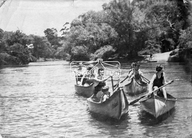 Eltham District Historical Society Inc
Negative - Photograph, Canoeing on the Yarra River at Warrandyte, Nov. 1934
This photo forms part of a collection of photographs gathered by the Shire of Eltham for their centenary project book,"Pioneers and Painters: 100 years of the Shire of Eltham" by Alan Marshall (1971). The collection of over 500 images is held in partnership between Eltham District Historical Society and Yarra Plenty Regional Library (Eltham Library) and is now formally known as the 'The Shire of Eltham Pioneers Photograph Collection.' It is significant in being the first community sourced collection representing the places and people of the Shire's first one hundred years.Digital image 4 x 5 inch B&W Negshire of eltham pioneers photograph collection, warrandyte, canoeing -
 Vision Australia
Administrative record - Text, Vision Australia 2020-2021 Annual Report, 2021
Annual report providing overview of activities and achievements including: the impact of Covid 19 upon operations, extension of telehealth services, use of Webinars for instructive sessions, improvements in online services such as VAConnect App, Envoy and Kiosk, partnership with Lego to launch Lego Braille Bricks in Australia, and Carols by Candlelight was held without a live audience for the first time. 1 volume with illustrations providing overview of organisational achievementsvision australia, corporation records, andrew moffat, ron hooton, abi howes, natalie kaine, nikki hind, sylvie palladino, david hobson, marina prior, lissette molina, paige coleman, anne ruston, chris edwards, greg hunt, katie allen, david hurley, matthew layton, caitlin smith, carly vaughan, stephen jolley, justine heath, nigel mapes, susan diver -
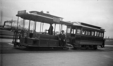 Melbourne Tram Museum
Negative, Wal Larsen, 1937c
Negative of a cable grip car at the Port Melbourne terminus, c1937, with the grip man and conductor on the grip car. Trailer 449. In the background is Station Pier and shipping. The grip car has the destination of Collins St on the front and "Connects with Collins St electric cars" on the side. Photographer could be Wal Larsen based on negative size - see Reg Item 5064.Written on rear of album print "Cable tram No. 449 at Port Melbourne terminus"trams, tramways, cable trams, port melbourne, station pier, tram 449 -
Koorie Heritage Trust
Journal - Serials, Aboriginal Law Research Unit in association with the Legal Service Bulletin Co-operative Ltd., 1981-1997, Aboriginal Law Bulletin, 1981
Aboriginal Law Bulletin began in 1981 as one of the first projects of the Aboriginal Law Research Centre at the University of NSW. The Centre became the Aboriginal Law Centre in 1986 and the Indigenous Law Centre in 1997; journal title changed to Indigenous law bulletin from Vol. 4 no. 1 (Apr. 1997)v. ; 29cm.Aboriginal Law Bulletin began in 1981 as one of the first projects of the Aboriginal Law Research Centre at the University of NSW. The Centre became the Aboriginal Law Centre in 1986 and the Indigenous Law Centre in 1997; journal title changed to Indigenous law bulletin from Vol. 4 no. 1 (Apr. 1997)law -- australia -- periodicals | aboriginal australians -- legal status, laws, etc. -- periodicals | torres strait islanders -- legal status, laws, etc. -- periodicals | race discrimination -- law and legislation -- australia | discrimination in law enforcement -- australia -- periodicals | government policy | law - indigenous | law - international law - human rights | law - legal system | law - legal aid services | race relations - racial discrimination - legislative | politics and government - social justice -
Whitehorse Historical Society Inc.
Map, Springvale Road, 1990
Aerial photograph of cnr Springvale Road and Burwood Highway, south past Highbury Road, west to Middleborough Road and east to Morack Road Vermont South.Aerial photograph of cnr Springvale Road and Burwood Highway, south past Highbury Road, west to Middleborough Road and east to Morack Road Vermont South.Aerial photograph of cnr Springvale Road and Burwood Highway, south past Highbury Road, west to Middleborough Road and east to Morack Road Vermont South.aerial photographs, morack road, vermont south, burwood highway, burwood east, springvale road, burwood east, highbury road, burwood east, burwood east, vermont south -
 Eltham District Historical Society Inc
Negative - Photograph, J.A. McDonald, Eltham, Cecil Street, Sep. 1959
Stabilising junction with Eltham-Yarra Glen Road View looking west across Main Road to the railway lineRecord of various Shire of Eltham infrastructure works undertaken during the period of 1952-1962 involving bridge and road reconstruction projects, sometimes with Eltham Shire Council Project Reference numbers quoted. It was during this period that a number of significant improvements were made to roads and new bridges constructed within the shire that remain in place as of present day (2022). In many situations, the photos provide a tangible visible record of infrastructure that existed throughout the early days of the Shire. The album was put together by or under the direction of the Shire Engineer, J.A. McDonald.infrastructure, shire of eltham, road construction, cecil street, eltham, eltham-yarra glen road, main road, 1959-09 -
 Ringwood and District Historical Society
Map, Proposed Subdivision - Hilltop Estate, Heathmont, Victoria - circa 1925
Plan of Part of Crown Allotments 16 & 18, Parish of Ringwood, County of Mornington. Subdivision includes Site for Heathmont Station, Heathmont Road, George Street, Lilian Street, Edith Street, Edna Street, Great Ryrie Street. Inset locality plan also shows nearby Electric Railway Estate and Heathmont Station Estate. L.H. Webber, Licensed Surveyor, 440 Little Collins Street, Melbourne. -
 Ringwood and District Historical Society
Archive, Winnington Grammar School, Ringwood - Archive Collection (Parent Record)
This record is the parent for all the Winnington Grammar School items in the RDHS collection -
Bendigo Historical Society Inc.
Map - NERRING : COUNTY OF BENDIGO, August 1952
Map. Nerring, County Of Bendigo. Yarraberb, Neilborough, Huntly, Sandhurst, Leichardt, Marong. Drawn and reproduced at the Department of Lands and Survey, Melbourne,Victoria. August 1952, Price 2/-. By Appointment J.J. Gourley, Government Printer, Melbourne. (number 0 in map cupboard 1)J.J. Gourley,Government Printermap, bendigo, nerring