-
 Mission to Seafarers Victoria
Administrative record - Annual Report, Mission to Seafarers Victoria, Annual Report 2019, 2020
annual report, 2019 -
Canterbury History Group
Photograph - Canterbury station, Hazel Merlo, 1965
Photocopy of a photograph of the old Canterbury railway station, south side ( to Melbourne) taken by Hazel Merlo in 1965canterbury, canterbury road, canterbury station, railway stations -
Moorabbin Air Museum
Document (Item) - Random documentation (Kerle) re Westland - Sikorsky S-51 Dragonfly
-
 Kew Historical Society Inc
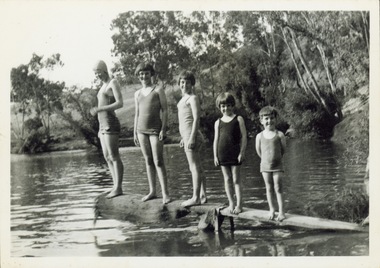
Photograph - Children on a diving platform on the Yarra at Kew, 1940s
The River Yarra was a traditional place of recreation for children and adults in Kew. Often swimming in the Yarra was made from platforms attached to the bank such as this one.Original black and white photograph. Group of five children in bathing costumes on a rudimentary diving board attached to the bank of the River Yarra.Reverse: "M Holmes"river yarra, recreation --- swimming -
 City of Kingston
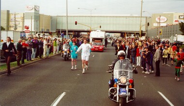
Photograph - Colour, 31 July 2000
The Olympic Games were held in Sydney in 2000. The Olympic torch progressed through Australia and prominent sporting or cultural identities were invited to carry the torch through their local areas.Colour photograph of David Douglas running in the Olympic Torch Relay as torch bearer. There is a police escort on motorbike in front and behind him, as well as a cavalcade of vans and cars behind him. Both sides of the street are lined with spectactors.Handwritten in black ink on reverse: David Douglasolympics, torch relay -
 Stawell Historical Society Inc
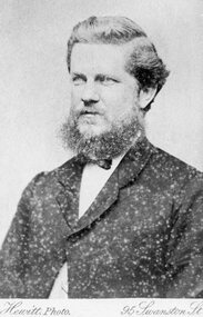
Photograph, Mr Joseph Shilton -- Bricklayer 1870 -- Studio Portrrait
Portrait. Bricklayer Joseph Shilton 1870stawell -
Federation University Historical Collection
Photograph, Graphic Design Students, 2001
Display of student work, including Clair Blake, winner of the Selkirk Ceramics Award.Four photographs of graphic design students.graphic design, goodbye to mount helen, claire blake, selkirk ceramics award -
 Ballarat Tramway Museum
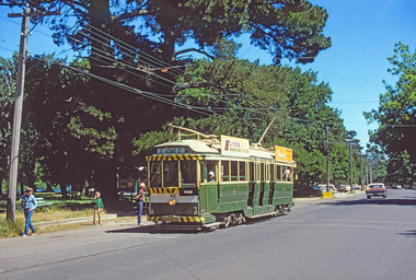
Photograph - Digital image Set of 6, W. J. Llewelyn, BTPS tram 40 making its first trip along Wendouree Parade, 7/12/1974 12:00:00 AM
Yields information about the establishment by the BTPS of a tram service in Wendouree Parade. Has a strong association with those involved.Set of six images of BTPS tram 40 making its first trip along Wendouree Parade following the installation of the depot junction trackwork on Saturday 7 December 1974. .1 at Gardens Loop .2 to .6 at St Aidans Drive Features Richard Gilbert, Len Millar and Geoff Cargeeg. Images scanned and altered by Roderick Smith from the Hugh Ballantyne collection August to September 2017.trams, tramways, opening, first tram, btps, wendouree parade, gardens loop, st aidans drive, tram 40 -
 Surrey Hills Historical Society Collection
Photograph - 8 Wilson Street, Surrey Hills, The Street Where You Live Project
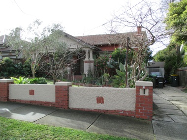
Photos documenting this address as part of a photographic series undertaken by volunteer photographers during 2013 and 2014 for The Street Where You Live Project. This was organised through the Surrey Hills Neighbourhood Centre and covered the postcode 3127 in the cities of Boroondara and Whitehorse.These photos provide a snapshot of real estate in the suburbs of Mont Albert and Surrey Hills during a period of rapid change with many properties on large blocks demolished to create higher density residential development or renewal of single dwellings. At particular risk were properties not covered by heritage overlays, especially interwar housing and post 1950's housing. -
Bialik College
Photograph (Item) - Daphne Gaddie at the first exhibition in the ELC at the Auburn Road campus
ELC staff member Daphne Gaddie at the first exhibition in the ELC at the Auburn Road campus, following the move from Shakespeare Grove, c. 1995. Please contact [email protected] to request access to this record.1990s -
 Kilmore Historical Society
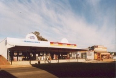
Photograph, 75 Sydney Street
15cm x 10cm coloured photograph of the shopfronts of Kilmore All Sports and AutoPro. These were housed in the same building that was being constructed in PHO-00067.shop fronts, store fronts, retail stores -
 Melbourne Tram Museum
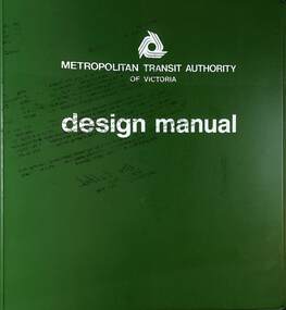
Manual, Metropolitan Transit Authority (MTA), "The Met Design Manual", 11/1984
Document - The Met design or style manual details the Corporate Identity to be used on all publications, and documents including logos, logotypes, symbols, standard lettering, and colour. Has a table of contents. The design manual is dated Nov 1984, just over one year after the creation of The Met - see reference. Parts 2, and 4 to 9 are missing insert pages.Demonstrates a Style Guide or Design Manual used by The Met in Melbourne.Document - multi ring binder green plastic covers, with approx 40 sheets, full colour, including table of contents.the met, design, style guide, logos, colour schemes -
 Bendigo Military Museum
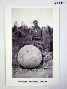
Photograph - PHOTOGRAPH WW2, Post 2000 reproduction
STANLEY BAYLISS (VX138816) enlisted on 7.5.1943 & discharged on 26.3.1946. On discharge he was listed as being posted as a Private to 2/108 General Transport.Photo of a soldier with a Japanese landmine, Tarakan“Japanese Landmine, Tarakan”photography-photographs, military history - army, mine -
 Ringwood and District Historical Society
Photograph - Colour, Archie and Ruby Harkeer with two teenagers
Ruby and Archie with two young peopleColoured photograph of the harkers and two teenagers -
 Old Colonists' Association of Ballarat Inc.
Photograph, President Jo Barber receives the Collar of the Old Colonists' Association of Ballarat Inc. from fromer President Jamie Sleep, 21/11/2019
Around four months after becoming President of the Old Colonists' Association the Covid19 pandemic hit, and by March 2020 Ballarat was in lockdown. Association Council meetings continued online, residents of the retirement village were kept informed of safety requirements during the pandemic, and 3 additional units were built at the Charles Anderson Grove Retirement Village. A Conservation Management Plan was also commissioned for the Old Colonists' Hall.Colour photographs of Jo Barber President of the Old Colonists' Association of Ballarat Inc giving her inaugural speech As President. .The photograph was taken in the Old Colonists' Hall.ballarat old colonists' association, ballarat old colonists' hall, jo barber, president, covid19, pandemic -
 Eltham District Historical Society Inc
Photograph, Betty Lynch (left), Russell and Marion Yeoman at the Everard Memorial, Mt Everard, Kinglake National Park, c.April, 2004
Betty Lynch OAM, daughter of William Everard and sister of Blanche Shallard This photo appears to have been taken at a later date to the dedication ceremony of 22 April.This lockup used to be located at the Police Station in Pryor Street and was then stored in Youth Road before being acquired for the Local History Centre Colour photographbetty lynch, everard memorial, mt everard, kinglake national park, blanche shallard -
 Southern Sherbrooke Historical Society Inc.
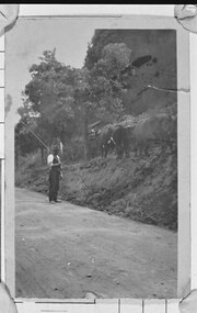
Photograph - Bill Hermon Snr and his bullock team
B&W photo of Bill Hermon Snr standing on a dirt road, wearing a hat, shirt, waistcoat and trousers, and holding a long bullocky's whip over his right shoulder. The land to the right of the photo rises steeply and is treed. Bill's bullock team is on a track or ledge about a metre above the road level. The first four animals can be seen. Photo dated 1913-1925. -
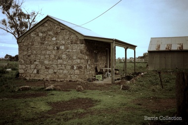 Melton City Libraries
Photograph, Darlingsford, Unknown
Darlingsford propertylocal identities, local architecture, council -
Malmsbury Historical Society
Photograph (Item), Church Of England, Malmsbury ca1970
Buildings - St John's Church -
Port Melbourne Historical & Preservation Society
Photograph - Port Melbourne Trugo Club, 1960s
Colour photograph of women of the Port Melbourne Trugo club late 1960s (Annie Smallpage 3rd from right front row)sport - trugo, annie smallpage nee griffiths, port melbourne trugo club -
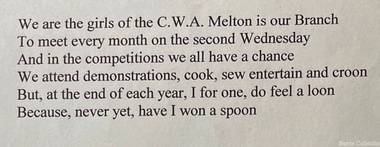 Melton City Libraries
Document, Country Women's Association Song Lyrics, c.1960
MABEL nee ABRAHAM ROGERS 1920 - 2004 Publications: The First One Hundred Years 1870-1970 Melton State School No 430 Co Author with Edna Barrie The Mechanics [Melton] 1985 Mabel Abraham was daughter of Herbert G Abraham, Butcher of High Street Melton. She attended Melton State School from 1928 qualifying for her Merit certificate in December 1928 and continued her education at Melbourne Girls High School [soon after known as MacRobertson Girls High School] She studied piano and elocution as a school girl. Mabel was associated with many activities in the Melton community. She was a natural writer and interested in research and was committed to documenting and preserving Meltons History. Mabel produced, wrote and acted for the “ Melton Amateurs” theatrical group established in 1950. The group performed Revues, Pantomimes, one and three act plays, Musical Comedy and Melodramas. In 1960 it lapsed for a time and from 1967 onwards more shows were successfully produced by Mabel. A creative producer and writer, audiences at the Melton Mechanics Institute enjoyed the performances of Gilbert and Sullivan and excerpts from the many Musicals of the era. She skilfully wrote scripts interweaving with songs and topical local dialogue successfully drawing out the talents of all the cast members. Mabel was a member of the C.W.A. holding position of Secretary. She was a member of the Melton and District Historical Society at its inception in 1968 and was a Member of The Willows Committee of Management. She was supporter of the first historical display and the Mechanics Hall and the Historical Society Annual Art and Craft shows from 1974 until 1982. In 1961 she was involved with Melton Development Association and in 1969 with the establishment of the first “Carols by Candlelight” held in Melton. Mabel was a member Anglican Church and Committee. She was a member of the Melton Mechanics Institute and made a Trustee and Life Member in 1965. She was a member of Victoria 150th Anniversary Celebration Committee. She was Guide Leader, member of the Red Cross and School Committee. In November 1982 she was a recipient of the Annual Rotary Community Service Award for outstanding service to the Community of Melton over a prolonged time. Mabel married Eric Rogers in August 1944 the wedding reception was held at the Melton Mechanics Hall. Their are children John, Ron, Francis and Judy. The family lived in High Street Melton between the Mechanics Institute and earliest Shire Hall eastern end. Eric was grader operator on the district roads. In their latter years Mabel and Eric lived in Bacchus Marsh. Eric died in Bacchus Marsh in July 2007. Country Women's Association Melton Branch lyrics from Mabel Roger's handwritten noteslocal identities, local significant groups -
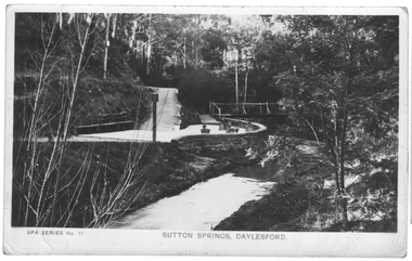 Ballarat Heritage Services
Photograph - Photograph - Black and White, Sutton Spring, Daylesford
Sutton Mineral Water Spring is located at Central Springs in Daylesford.A spring at Daylesford is surrounded by a drystone wall, known as Sutton Spring.mineral water, sutton spring, daylesford, central springs -
Moorabbin Air Museum
Manual (item), Viscount 800 Series Aircraft Manual Volume 3
-
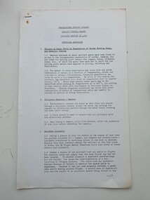 Moorabbin Air Museum
Document (Item) - Headquarters Support Command Quality Control Branch Training Leaflet No 4/67 Technical Abstracts
A training leaflet about quality controlquality control -
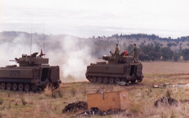 8th/13th Victorian Mounted Rifles Regimental Collection
Photograph
Standard entry 5Colour photograph of two M113 A1 Fire Support Vehicles of A Squadron 8/13 Victorian Mounted Rifles on range at Puckapunyal c.1987.fsv, puckapunyal, vmr, training -
 Eltham District Historical Society Inc
Photograph - Aerial Photograph, Landata, Eltham; Crown Allotment 15, Section 5, Parish of Nillumbik (Stokes Orchard Estate), Nov. 1931
Centred over present day Reynolds Road and Mount Pleasant Road, Eltham (including Diosma Rd, Stokes Pl, Nyora Rd and Eucalyptus Rd) Historic Aerial Imagery Source: Landata.vic.gov.au Aerial Photo Details: Project No :1931 Project : MALDON PRISON Run : 21 Frame : 3160 Date : 11/1931 Film Type : B/W Camera : F8 Flying Height : 11000 Scale : 18860 Film Number : 60 GDA2020 : 37°43'31"S, 145°10'20"E MGA2020 : 338912, 5823086 (55) Melways : 22 E8 (ed. 42) A History of the Development of Crown Allotment 15, Section 5, Parish of Nillumbik – Stokes Orchard Crown Allotment 15, Section 5, Parish of Nillumbik (CA15) is a square allotment of 158 acres or approximately a quarter of a square mile. It lies just beyond the eastern end of Pitt Street, south of Nyora Road to the northern end of Eucalyptus Road and extends east from Eucalyptus Road to Reynolds Road. The topography of CA15 is generally steep, sloping up to a hill near the centre of the land, the ridgeline passing through the properties along the southern side of Diosma Road. Eucalyptus Road is a straight north-south road with its northern end at the north west corner of CA15. Until the end of the 1970s this road was an un-named Government Road and was largely not open to traffic. With residential development in the 1970s the road was constructed, and the council allocated the name obviously in recognition of the predominant species of the local bushland. CA15 was purchased from the Crown by George D’Arley Boursiquot, a prominent Melbourne printer, on 28th October 1852. On November 23, 1922, former Member for Gippsland and Melbourne Real Estate Agent, Hubert Patrick Keogh purchased the allotment then sold it March 13, 1925, to local farmer, Robert David Taylor, a former Shire of Eltham Councillor (1911-1920) and Shire President (1919). Taylor had extensive land holdings stretching west towards Bible Street and Main Road. The Taylor home was situated at the top of the hill in Bible Street at present day 82 Bible Street. At the time of Taylor’s purchase in 1925, CA15 was subdivided into 48 lots that could be described as small rural properties or large residential lots. A typical lot size was one hectare or 2.5 acres. The subdivision created two roads, Nyora Road, and Diosma Road, each following an irregular alignment between Eucalyptus and Reynolds Roads. However, the lots were not sold off separately nor were the roads constructed. The land effectively remained as one parcel for many further years. Robert David Taylor died November 30, 1934, and probate was granted to his son of the same name, Robert David Taylor of Bible Street, Salesman and William McLelland Vance Taylor of 73 Emmeline Street, Northcote, Clerk, with the transfer of the land into their names on July 8, 1935. Frank Stokes worked as a qualified accountant at Kennons leather factory in Burnley, while living at 1 Thomas Street, Mitcham. He suffered from migraines and wanted to return to working the land (he had previously worked on farms and orchards since coming to Australia from England in 1926, both in WA and Vic.). He first travelled to the district by train in July 1942 to find land with the intention to establish an orchard. By chance he met Arthur Bird of Bird Orchard (bounded by Pitt Street, Eucalyptus Road, and Wattle Grove) and they got talking over their common interest. Arthur put Frank up for the night and pointed out the land, 158 acres- part of the Taylor Estate- £900, Crown Allotment 15, Section 5, Parish of Nillumbik (CA15) somewhat diagonally opposite Bird Orchard. Stokes applied through the Riverina Agency to purchase the land who in turn applied for permission from Canberra to sell as there was a new government regulation introduced during the Second World War banning land sales except for immediate production. Stokes obtained a loan on his Mitcham house of £600 @ 5% and paid £450 deposit with quarterly payments of £15 spread over 5 years. Stokes was assisted and advised by Arthur Bird who farmed the neighbouring orchard. In early 1943 Stokes took possession and would catch the train out to Eltham on Fridays after work and began building a hut on the corner of Nyora Road and the Government Road (Eucalyptus Road) for shelter and to lock up tools. He established an orchard on the central western part of the land through the centre of which ran a natural waterway (part of the present-day linear park) and was able to pay a neighbour (Hawkins) to help with clearing and fencing 25 acres, and with a horse and single furrowed plough, planted approximately 2,500 fruit trees - cherries, peaches, plums, almonds, pears, apricots and lemons as well as a few apples and oranges; a massive task. Aerial photographs from the 1940s through to the 1990s clearly show the orchard with most of the larger CA15 site remaining as natural bushland. A huge problem was hares and rabbits eating all the new buds off the tiny trees. As well as laying poison he painted the trees with a mixture of cow manure and lime, often working by moonlight. Procurement of wire and wire netting was difficult because of the war but after much effort he obtained a permit from the Agricultural Department for supplies in March 1944. In February 1945 Stokes applied for a permit to build a “packing shed” as no house building was allowed. It was to be 33 feet x 21 feet and cost £312. It was constructed mostly from second-hand materials, which were hard to obtain, especially iron for roofing. Stokes finished work at Kennons on October 31, 1945, and in March 1946 he sold the family home at Mitcham for £1,230 plus £170 for furniture. On May 15, 1946, title to the CA15 property was issued to Frank Howard Alfred Stokes, Orchardist and Gladys Ethel Stokes, Married Woman, both of Pitt Street, Eltham. The family of five then moved into the very unfinished “packing shed” at Eltham, which was a struggle to weatherproof. Eventually rooms were divided off and lined with hessian bags and whitewashed. Their income was firewood (cut and sold), selling rockery stones and cut Sweet Bursaria. (It was discovered during the 1940s that Sweet Bursaria contained the sunscreen compound Aesculin. The RAAF utilised this compound from Sweet Bursaria during WW2 for pilots and gunners.) The orchard’s first fruit sale was a half-case of Le Vanq peaches in December 1947 for the price of 8 shillings. In 1956 plans for house were drawn and Glen Iris bricks purchased (1956 Olympic Rings variant). The building of the house commenced in 1957 - 12 feet of original packing shed was removed – and was completed in 1959. Water was connected from newly built pressure storage on the property at the end of 1959 and the electricity connection for the first time at 3pm on April 29, 1960. The house remains to present day (somewhat modified) at 1 Nyora Road, home to Nyora Studio Gallery. On occasions, spare remnants of the 1956 bricks have been known to be unearthed in gardens on the estate as they were utilised by Frank Stokes to fill in rabbit holes. On May 26, 1950, a parcel of land was compulsorily acquired by the Melbourne and Metropolitan Board of Works on the hilltop to establish an easement for a high-level service reservoir to augment Eltham’s water supply. The project also included pipe tracks for the necessary water mains. The reservoir has now been superseded by higher level water tanks east of Reynolds Road and its former site is now a public reserve. On November 27, 1964, the State Electricity Commission served notice to compulsorily acquire a further parcel through the eastern part of the land for a major electricity transmission line that augmented supply from the La Trobe Valley to Melbourne. The easement was registered February 11, 1966. The easement was widened July 18, 1969 for a second transmission line to be constructed. In 1971 Melbourne Metropolitan Planning Scheme amendments adopted Nyora Road as the boundary between a residential zone to the north and a rural zone to the south. This determined the future development of the land. In the mid-1970s the Shire of Eltham divided the orchard into numerous rate-able parcel lots, the 48 lots having been established in 1925 and the subsequent rates assessment proved unsustainable for Stokes. He commenced selling lots outside the boundary of the orchard, north of Diosma and South of Nyora. However shortly later the land between Nyora and Diosma Roads and west of the electricity easement was sold and subdivided into residential lots, a housing development by Macquarie Builders and marketed as the Stokes Orchard Estate. New streets were created, and most were named after trees, although one, Stokes Place, commemorates the former owners. The development was undertaken in two stages; Stage 1 (1975) encompassing Scarlet Ash Court, Ironbark Close and Peppermint Grove bounded by Nyora and Eucalyptus roads and Stage 2 (1978) encompassing Stokes Place, Orchard Way, The Crest and The Lookout bound by Nyora and Diosma roads. The developer, Macquarie Builders went bankrupt shortly after the release of Stage 2 leaving many purchasers to fend for themselves and arrange for their own independent builders. There were also difficulties with sewerage for the land immediately south of Diosma Road and so the conventional residential lots were abandoned in favour of larger lots. The development of Orchard Way, The Crest and The Lookout did not proceed as planned and the proposed lots were incorporated into five-acre parcels instead. These included a low-density group housing development by the Graves family and the award winning Choong House (1983) with Gordon Ford developed garden immediately next door situated on the ridge of the hill nestled amongst the original bush, Eucalypt trees and Sweet Bursaria. In 1994, Nillumbik Shire Council applied Significant Environment and Significant Landscape overlays upon the properties on the south side of Diosma Road to ensure protection of this natural bush garden environment. With the arrival of the sewer along Diosma Road in the 1990s, most of these five-acre parcels have since been subdivided multiple times. The Choong house presently sits on a 2.7-acre property, which in 2022 Nillumbik Council nominated for Cultural Significance Heritage protection and is considered potentially significant at State level. The Stokes family were also associated with the Eltham Christian Church. In the 1970s this church had met in temporary premises in Eltham. Lots of the original 1925 subdivision remained south of Nyora Road and a number of these lots were utilized for the Eltham Christian School, which was established by the Eltham Christian Church in 1981. The school operated on this site until 2000. The premises are now used by The Vine Baptist Church. By the mid-1980s the whole of CA15 had been developed for residential and school purposes, except for the sections north of Diosma Road and between the transmission lines and Reynolds Road. Sewerage issues had been resolved for the section north of Diosma Road and in 1987 it was in the process of being subdivided into residential lots. The development coincided with the discovery of colonies of the rare and endangered Eltham Copper Butterfly on the site. This resulted in a community and political campaign to save the butterfly habitat. With the co-operation of the land developer the subdivision was altered to create two bushland reserves in the critical butterfly habitat areas. In the late 1980s the State Government was investigating options for establishing a metropolitan ring road link between Diamond Creek and Ringwood. The chosen route was adjacent to Reynolds Road and so this created a freeze on development of CA15 between Reynolds Road and the electricity easement. The ring road proposal was eventually abandoned, and this part of the land was subdivided into low density residential lots. Diosma Road has been discontinued at the electricity easement and the eastern part incorporated into View Mount Court with access from Reynolds Road. The whole of CA15 has now been developed for residential or associated purposes, ranging from conventional density to quite low density south of Nyora Road. Some remnants of the orchard remain, a few cherry trees on the Graves property and a lone apple tree in Stokes Place. The butterfly reserves comprise significant areas of remnant bushland. Linear reserves through the estate link with central Eltham via the Woodridge linear reserve and with Research along the electricity easement. CA15 as it exists today has a complicated history of rural use, Government acquisition, urban development, and community action. References: • “Stokes Orchard, an incomplete history”; Russell Yeoman with Doug Orford • Correspondence, Beryl Bradbury (nee Stokes) • Aerial Photographs, 1931-1991, Landata (landata.vic.gov.au) • Certificate of Title, Vol. 4930 Fol. 985900 • Plan Number LP 10859 aerial photo, diosma road, eltham copper butterfly, eucalyptus road, ironbark close, nyora road, peppermint grove, peter & elizabeth pidgeon collection, power transmission lines, reynolds road, scarlet ash court, stokes orchard estate, stokes place, woodridge estate, frank stokes -
Moorabbin Air Museum
Manual - CAC Commonwealth Aircraft Corporation Ltd RAAF Basic Trainer Data Item Description No. E204, Definition of Windscreen Canopy Interim Report
-
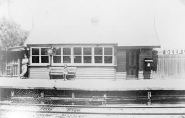 Stawell Historical Society Inc
Photograph, Deep Lead Railway Station c1970
Deep Lead Railway Station c1970stawell deep lead -
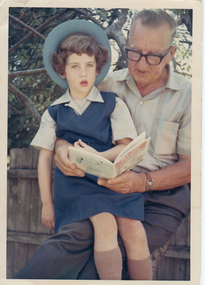 Ballarat Heritage Services
Photograph, Clare Gervasoni and Gus Gervasoni
Colour photograph of Clare Gervasoni posing for a photograph with her Grandfather, Gus Gervasoni, on the first day of school. Clare is wearing the old St Anne's East Kew summer uniform. The winter uniform was the same, but the tunic was in wool, and the grey shirt had long sleeves. It was worn with a blue jumper and blazer, and in winter a tie.gus gervasoni, ann gervasoni, school uniform, first day of school, st anne's east kew -
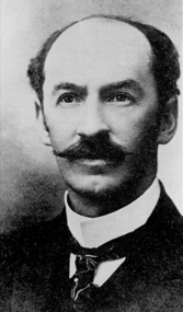 Federation University Historical Collection
Photograph - Photograph - Black and White, Frank Tate, c1910
Frank Tate was the Director of Education with the Victorian Education Department. He was born on 18 June 1863 at Castlemaine. He died on 28 June 1939 in Melbourne.Photographic Portrait of Frank Tate, the first Director of Education in Victoria (1902-1928).frank tate, victorian department of education, education