-
 Lakes Entrance Regional Historical Society (operating as Lakes Entrance History Centre & Museum)
Photograph, Lakes Post Newspaper, 1992
Black and white photograph of Mark Johnson and Allison Sweeny on their wedding day Kalimna West Victoriacelebrations -
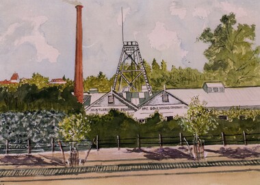 Bendigo Historical Society Inc.
Photograph - JOHN HALL COLLECTION: PHOTO OF THE ORIGINAL WATER COLOUR PAINTING: HUSTLERS REEF NO2
JOHN HALL COLLECTION: Photo of the original WATER COLOUR Painting: HUSTLERS REEF NO2John Hallartwork, water colour, gold mines -
 Lakes Entrance Regional Historical Society (operating as Lakes Entrance History Centre & Museum)
Photograph, Lakes Post Newspaper, 1995
number in album 03602.04Black and white photograph Golf Club members, Wendy Balfour, Cam Gray, Mary and Patrick Renehen practicing tee offs. Lakes Entrance Victoriagolf club, sports -
Port Melbourne Historical & Preservation Society
Photograph - Stained glass window, Holy Trinity Anglican Church, Port Melbourne, Jim Hillis, 1996
Photos taken by Jim Hillis prior to final sale of church, and donated to the PMH&PS. Society subsequently located a home for the windows with a church in Richmond, Vic.Photo of backlit stained glass window to left of altar: 'Glory to God in the Highest' --- from set of nine colour photos of vacated interior of Holy Trinity Churchreligion - anglican (holy trinity), jim hillis -
 Mission to Seafarers Victoria
Photograph - Photograph, Colour, 1991?
The centre is at the main dock gate (Corry Road) within easy walking distance of most ships on North Shore. Facilities include a Flying Angel Centre with free Wifi & computer access, a bar and café, currency exchange, a choice of mobile phone & internet cards, pool table, chapel, gift shop, clothes shop and lounge area. Belfast is one of the many centres from the Mission to Seafarers network around the world.Mission located in the docks in Belfast North Ireland. Behind is the St Joseph's Church Sailortown.mission to seafarers, seamen's mission, mission to seamen, belfast, north ireland, ports -
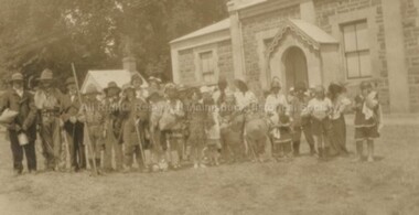
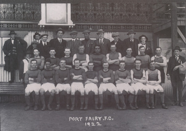 Port Fairy Historical Society Museum and Archives
Photograph, 1922 Port Fairy Football Club
LocalBlack & white photographPort Fairy FC 1922port fairy, football club, team and admin staff -
 Eltham District Historical Society Inc
Photograph, Alison Delaney, Significant Eucalyptus tree, Diamond Creek Trail, Alistair Knox Park, Eltham, 21 Feb 2020
This tree is a significant tree located beside the Diamond Creek Trail in Alistair Knox Park. It was identified as the same tree in earlier photos from the 1980s. This images was taken just before the COVID-19 pandemic hit and the tree also has been tagged with grafitti on its trunk.alistair knox park, diamond creek trail, grafitti, significant tree -
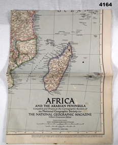 Bendigo Military Museum
Map - MAP, COLOURED, The National geographic Magazine, Africa & the Arabian Peninsula, March 1950
Part of the collection of Frederick Gardner Davey DFC No 410533 RAAF. Refer Cat No 3536P for his service details.Coloured political map featuring borders,towns,and Allies, small physical inset in bottom LH corner.maps, africa, arabian -
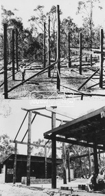
Moorabbin Air Museum
Photograph - (SP) No Title collection of photographs, (SP) Building of CAC Lidcombe site 27/04/1940 ,photos of construction ,workshops , facilities cac lidcombe was used to build 1200hp twin wasp engines , photos of engine components
-
 Kew Historical Society Inc
Photograph - Former Kew Police Station : East facing facade, 1996
A civic campaign for new public offices developed in Kew in the 1880s. After much deliberation, the location chosen was the junction of Bulleen and Cotham Roads. The buildings were designed by George Watson and John Henry Harvey, architects within the Department of Public Works (Victoria). Building was commenced in 1887, and after one year, the buildings were opened. The Post Office was transferred to the new Commonwealth Government in 1901. The Police Station and Court House, sold by the Victorian Government to the City of Boroondara in 2007, are now a community cultural centre and performing arts venue.The buildings were listed on the Victorian Heritage Register Register (HO885) in 1991. They are historically and architecturally significant to the State of Victoria because Watson and Harvey's designs exhibit diversity in integrating civil offices, they accommodate the apex of road junctions, and they demonstrate a departure from the contemporaneously favoured High Victorian Classical to the Queen Anne style in the design of civic buildings.Exterior view of the east facing red brick facade of the former Kew Police Station in High Street, Kew.kew court house, public offices -- kew (vic), kew police station -
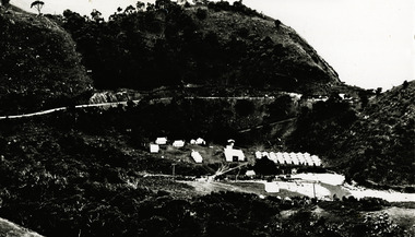 Lorne Historical Society
Photograph, Grassy Creek C.R.B. Camp
Photo of the Grassy Creek C.R.B site looking towards Aireys Inlet. Top left hand corner - the first tents were the gangers next were the mine and the third the timekeepers. The camp site is in the valleyg.o.r.; c.r.b. construction camp sites; gangers; mine; timekeeper; grassy creek; -
 Eltham District Historical Society Inc
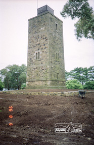
Photograph, Shire of Eltham War Memorial Tower, Memorial Park, Garden Hill, Kangaroo Ground Tower, 6 Aug 1996, 1996
On November 11th 1926 the Shire of Eltham War Memorial Tower at Kangaroo Ground was opened. It is regarded as one of Melbourne’s most outstanding lookout towers. It commands a magnificent 360 degree panorama from Kinglake across the Diamond Valley to Macedon and the You Yangs. It is built on a peak which was once a volcano, 237 metres above sea level. After World War one a memorial cairn was erected on the site, and in 1925 a committee of public-minded citizens began to plan for a tower. Many generous donations of material and money were forthcoming so that in 1926 the Governor General Lord Stonehaven was able to unveil the plaque before a crowd of 500 people. There was some concern in the 1960s when the Forests Commission wanted to build a firespotters cabin on the top. At first R.S.L. branches opposed the idea, but it was realised that this use could combine with its use as a tourist attraction, and would ensure its maintenance for the future, Today the Kangaroo Ground tower provides one of the best views around Melbourne and is a fitting memorial to those who died in two world wars. From: Historic items for Diamond Valley Community Radio September 1990 (EDHS collection) Roll of 35mm colour negative film, 7 stripsKodak Gold 100-5garden hill, kangaroo ground memorial, memorial park, shire of eltham war memorial tower, war memorial tower, war memorials -
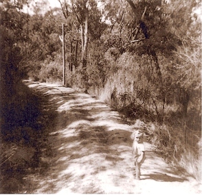 Greensborough Historical Society
Photograph, Greenhills, 1950c
This is a photograph of a small child (possibly Sue Darling) on a bush track identified as Albion Crescent in the Greenhills estate, Greensborough.This photograph shows the rural nature of this area of Greensborough in the mid 20th century, which is now suburban.Black and white photograph of a small girl on a country track.In pencil on back of photograph: "Albion Cres posssibly Sue Darling"greenhills, albion crescent, greensborough, sue darling -
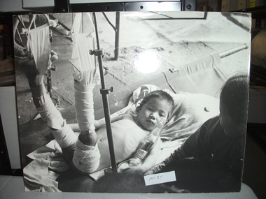 National Vietnam Veterans Museum (NVVM)
Photograph, Injured Baby
Black and White Photograph. A young boy lies on a stretcher with both his legs in traction.photograph, vietnamese children, medical -
 Malmsbury Historical Society
Photograph (Item), "B/W Photo Boxing Day Picnic Parade, Outside Town Hall", Malmsbury c1920
People - "Swainston, Jessie" Buildings - Town Hall Associated with - Boxing Day Picnic Parade -
Glenelg Shire Council Cultural Collection
Photograph - Photograph - Vessel 'Ixion' berthed to discharge a heavy lift for APML (Australian Paper Manufacturers), October 1959, 1959
Port of Portland Authority archives.Front: (no inscriptions) Back: October 1959, 'Ixion' cargo for APMLport of portland archives -
Malmsbury Historical Society
Photograph (Item), Bill Slimmon At Mhs Exhibition Sept 1991, Malmsbury 4/9/1991
People - "Slimmon, Bill; Manktelow, Dennis" Buildings - Town Hall Associated with - "Mhs, Daffodil Festival?" -
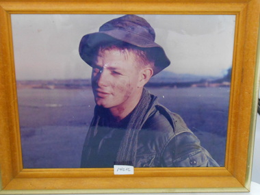 National Vietnam Veterans Museum (NVVM)
Photograph, Peter Beadle 4 RAR 1968, 1968
Framed Coloured Photograph of Peter Beadle in Jungle Greensphotograph, peter beadle, 4 rar -
Lakes Entrance Regional Historical Society (operating as Lakes Entrance History Centre & Museum)
Photograph, 1910c
Photo taken by Segerberg and Bulmer. TS363Large wooden framed photograph / mounted of Lakes Entrancephotography, photographs, slides, film -
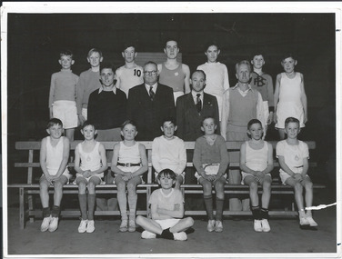 Melbourne Legacy
Photograph, Junior Legacy Classes, 1953
A class photo of a group of young legatees at a gymnastics class in Kew. There are 15 boys, of various ages, in gymnastics gear, and 4 men who are instructors and Legacy members. The caption says 'This photo was taken during school holidays, hence the small attendance. Front: Eddie Robertson, Sitting: Lohn LInton, Bob Bateson, Robin Broderick, Michael Johnson, Tom Olsen, Graeme Murray, Douglas Govey. Centre: Mr Tom Mann (instructor) Legatee HJ Martin, Legatee A R Beattie, Mr J Costello (Instructor). Back: John Barker, Kerry Wisdom, Garry Thomson, Gerald Brown, Rod MacKinnon, John Shaw, Graeme Withers. Legacy clubs ran classes for junior legatees for many years. It was part of providing for the children of their deceased comrades. The skills they learned were show cased in an annual demonstration usually at the Melbourne Town Hall. It appears to be photo taken professionally, as there are several photos of different classes (see 00862 - 00867) perhaps to record Legacy classes for promotion purposes.A record of a way Legacy provided classes for junior legatees.Black and white photo of Legacy boys posing for a class photo.Printed on the back 'Kew'. Stamped 'S5337/1--' and '531' in blue ink.junior legatee, boys' classes -
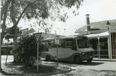 Ringwood and District Historical Society
Photograph, Ringwood black and white photographs
Black and white photographRingwood Station entrance, with National Bus Lines bus departing. -
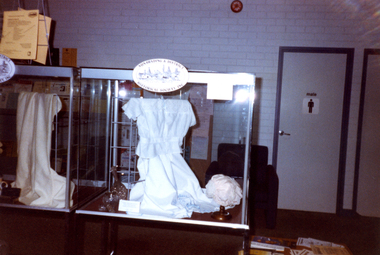 Whitehorse Historical Society Inc.
Photograph, Library Display, 1/04/2000 12:00:00 AM
Coloured photo of Society's Display for Heritage Week 2000 in Nunawading Library featuring Men's and Women's Underwear and Toiletries.heritage week 2000, nunawading & district historical society -
 Eltham District Historical Society Inc
Photograph, John Serle House and Studio (1971)
Image 27 John Serle House and Studio 1971 Designed by Alistair Knox Built by owner The Alistair Knox Collection The Alistair Knox Collection is a series of mounted enlarged photos of mud brick houses and related subjects. The collection is understood to have been put together by Alistair Knox although it is the work of several unacknowledged photographers. For some years it was held by the Building Department of the former Eltham Shire Council and was then passed to our Society for safekeeping. Some of the photos have been used in Knox's books and from time to time some of them have been part of various historical displays. As far as we know there has not been a public display of the whole collection which numbers about forty photographs. The collection has been copied on to slides for the purpose of this meeting and to be retained as part of the Society's pictorial collection. Alistair Knox 1912 - 1986 is acknowledged as the founder of Eltham's mud brick building movement. Many of the buildings shown in the collection are of his design and he was also involved with the construction of several of them. Others are the work of his contemporaries and associates such as Peter Glass, Gordon Ford, and John Harcourt. (EDHS Newsletter No. 145 July 2002)Handwritten notes in pencil re details of building, year of construction, owner, designer, builder, etcaistair knox collection, houses, john serle, john serle house, mud brick construction -
 Gippsland Art Gallery
Photograph, Oldfield, David, Kelly's Hut, Holmes Plain, 1993
Donated by the artist, 1997Silver bromide photographic printgippsland, artwork, permanent collection -
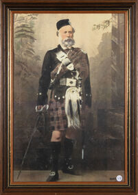 Ballan Shire Historical Society
Photograph - Macpherson, Dugald, Portrait of Dugald Macpherson
Full length coloured photograph of Dugald Macpherson of Bungeeltap in traditional Highland regalia, mounted under glass in a light brown wooden frame with black and gold trim.Dugald Macpherson original owner of Bungeeltap.macpherson dugald, ballan, bungeeltap -
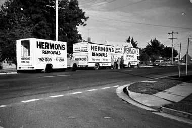 Southern Sherbrooke Historical Society Inc.
Photograph - Set of photos pertaining to Hermon's Removals, c. 1980s
Set of photos from c. 1980s pertaining to Hermon's Removals. William (Bill) Hermon Junior established a furniture removals business in 1935. Their depot was on the corner of Main Rd and Snodgrass St, Pakenham. When Bill's younger sons Ken and Ron, acquired the business in 1994 the business was renamed Hermon's Rainbow Removals, which remains in operation today. 1. Photograph of 3 trucks from Hermon's Removals on Main Road, Pakenham, down near McGregor Rd. Their depot was on the corner of Main Rd and Snodgrass St, Pakenham. 2. Photograph of one of Hermon's Removal trucks at Pakenham. 3. A photograph featuring three of Hermon's Removal Trucks lined up on a suburban street. 4. A photograph featuring Bill Hermon (second from the right of picture) and his sons, Ron, John and Ken. -
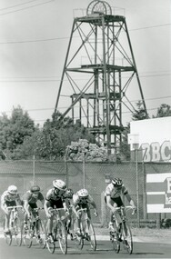 Bendigo Historical Society Inc.
Photograph - BENDIGO ADVERTISER COLLECTION: BIKES, 1990s
Photograph: Group of bike racers in Adams Street Bendigo On rear: Adams Streetrecreations, sports, cycling, bendigo advertiser -
 Eltham District Historical Society Inc
Photograph - Aerial Photograph, Landata, Eltham; Crown Allotment 15, Section 5, Parish of Nillumbik (Stokes Orchard Estate), Jan. 1951
Centred on present day Diosma Rd, Stokes Pl, Nyora Rd and Eucalyptus Rd Historic Aerial Imagery Source: Landata.vic.gov.au Aerial Photo Details: Project No :65 Project : MELBOURNE AND METROPOLITAN PROJECT NO. 2 Run : 8 Frame : 71 Date : 01/1951 Film Type : B/W Camera : EAG9 Flying Height : 12200 Scale : 12000 Film Number : 1419 GDA2020 : 37°43'14"S, 145°09'46"E MGA2020 : 338081, 5823608 (55) Melways : 22 C6 (ed. 42) A History of the Development of Crown Allotment 15, Section 5, Parish of Nillumbik – Stokes Orchard Crown Allotment 15, Section 5, Parish of Nillumbik (CA15) is a square allotment of 158 acres or approximately a quarter of a square mile. It lies just beyond the eastern end of Pitt Street, south of Nyora Road to the northern end of Eucalyptus Road and extends east from Eucalyptus Road to Reynolds Road. The topography of CA15 is generally steep, sloping up to a hill near the centre of the land, the ridgeline passing through the properties along the southern side of Diosma Road. Eucalyptus Road is a straight north-south road with its northern end at the north west corner of CA15. Until the end of the 1970s this road was an un-named Government Road and was largely not open to traffic. With residential development in the 1970s the road was constructed, and the council allocated the name obviously in recognition of the predominant species of the local bushland. CA15 was purchased from the Crown by George D’Arley Boursiquot, a prominent Melbourne printer, on 28th October 1852. On November 23, 1922, former Member for Gippsland and Melbourne Real Estate Agent, Hubert Patrick Keogh purchased the allotment then sold it March 13, 1925, to local farmer, Robert David Taylor, a former Shire of Eltham Councillor (1911-1920) and Shire President (1919). Taylor had extensive land holdings stretching west towards Bible Street and Main Road. The Taylor home was situated at the top of the hill in Bible Street at present day 82 Bible Street. At the time of Taylor’s purchase in 1925, CA15 was subdivided into 48 lots that could be described as small rural properties or large residential lots. A typical lot size was one hectare or 2.5 acres. The subdivision created two roads, Nyora Road, and Diosma Road, each following an irregular alignment between Eucalyptus and Reynolds Roads. However, the lots were not sold off separately nor were the roads constructed. The land effectively remained as one parcel for many further years. Robert David Taylor died November 30, 1934, and probate was granted to his son of the same name, Robert David Taylor of Bible Street, Salesman and William McLelland Vance Taylor of 73 Emmeline Street, Northcote, Clerk, with the transfer of the land into their names on July 8, 1935. Frank Stokes worked as a qualified accountant at Kennons leather factory in Burnley, while living at 1 Thomas Street, Mitcham. He suffered from migraines and wanted to return to working the land (he had previously worked on farms and orchards since coming to Australia from England in 1926, both in WA and Vic.). He first travelled to the district by train in July 1942 to find land with the intention to establish an orchard. By chance he met Arthur Bird of Bird Orchard (bounded by Pitt Street, Eucalyptus Road, and Wattle Grove) and they got talking over their common interest. Arthur put Frank up for the night and pointed out the land, 158 acres- part of the Taylor Estate- £900, Crown Allotment 15, Section 5, Parish of Nillumbik (CA15) somewhat diagonally opposite Bird Orchard. Stokes applied through the Riverina Agency to purchase the land who in turn applied for permission from Canberra to sell as there was a new government regulation introduced during the Second World War banning land sales except for immediate production. Stokes obtained a loan on his Mitcham house of £600 @ 5% and paid £450 deposit with quarterly payments of £15 spread over 5 years. Stokes was assisted and advised by Arthur Bird who farmed the neighbouring orchard. In early 1943 Stokes took possession and would catch the train out to Eltham on Fridays after work and began building a hut on the corner of Nyora Road and the Government Road (Eucalyptus Road) for shelter and to lock up tools. He established an orchard on the central western part of the land through the centre of which ran a natural waterway (part of the present-day linear park) and was able to pay a neighbour (Hawkins) to help with clearing and fencing 25 acres, and with a horse and single furrowed plough, planted approximately 2,500 fruit trees - cherries, peaches, plums, almonds, pears, apricots and lemons as well as a few apples and oranges; a massive task. Aerial photographs from the 1940s through to the 1990s clearly show the orchard with most of the larger CA15 site remaining as natural bushland. A huge problem was hares and rabbits eating all the new buds off the tiny trees. As well as laying poison he painted the trees with a mixture of cow manure and lime, often working by moonlight. Procurement of wire and wire netting was difficult because of the war but after much effort he obtained a permit from the Agricultural Department for supplies in March 1944. In February 1945 Stokes applied for a permit to build a “packing shed” as no house building was allowed. It was to be 33 feet x 21 feet and cost £312. It was constructed mostly from second-hand materials, which were hard to obtain, especially iron for roofing. Stokes finished work at Kennons on October 31, 1945, and in March 1946 he sold the family home at Mitcham for £1,230 plus £170 for furniture. On May 15, 1946, title to the CA15 property was issued to Frank Howard Alfred Stokes, Orchardist and Gladys Ethel Stokes, Married Woman, both of Pitt Street, Eltham. The family of five then moved into the very unfinished “packing shed” at Eltham, which was a struggle to weatherproof. Eventually rooms were divided off and lined with hessian bags and whitewashed. Their income was firewood (cut and sold), selling rockery stones and cut Sweet Bursaria. (It was discovered during the 1940s that Sweet Bursaria contained the sunscreen compound Aesculin. The RAAF utilised this compound from Sweet Bursaria during WW2 for pilots and gunners.) The orchard’s first fruit sale was a half-case of Le Vanq peaches in December 1947 for the price of 8 shillings. In 1956 plans for house were drawn and Glen Iris bricks purchased (1956 Olympic Rings variant). The building of the house commenced in 1957 - 12 feet of original packing shed was removed – and was completed in 1959. Water was connected from newly built pressure storage on the property at the end of 1959 and the electricity connection for the first time at 3pm on April 29, 1960. The house remains to present day (somewhat modified) at 1 Nyora Road, home to Nyora Studio Gallery. On occasions, spare remnants of the 1956 bricks have been known to be unearthed in gardens on the estate as they were utilised by Frank Stokes to fill in rabbit holes. On May 26, 1950, a parcel of land was compulsorily acquired by the Melbourne and Metropolitan Board of Works on the hilltop to establish an easement for a high-level service reservoir to augment Eltham’s water supply. The project also included pipe tracks for the necessary water mains. The reservoir has now been superseded by higher level water tanks east of Reynolds Road and its former site is now a public reserve. On November 27, 1964, the State Electricity Commission served notice to compulsorily acquire a further parcel through the eastern part of the land for a major electricity transmission line that augmented supply from the La Trobe Valley to Melbourne. The easement was registered February 11, 1966. The easement was widened July 18, 1969 for a second transmission line to be constructed. In 1971 Melbourne Metropolitan Planning Scheme amendments adopted Nyora Road as the boundary between a residential zone to the north and a rural zone to the south. This determined the future development of the land. In the mid-1970s the Shire of Eltham divided the orchard into numerous rate-able parcel lots, the 48 lots having been established in 1925 and the subsequent rates assessment proved unsustainable for Stokes. He commenced selling lots outside the boundary of the orchard, north of Diosma and South of Nyora. However shortly later the land between Nyora and Diosma Roads and west of the electricity easement was sold and subdivided into residential lots, a housing development by Macquarie Builders and marketed as the Stokes Orchard Estate. New streets were created, and most were named after trees, although one, Stokes Place, commemorates the former owners. The development was undertaken in two stages; Stage 1 (1975) encompassing Scarlet Ash Court, Ironbark Close and Peppermint Grove bounded by Nyora and Eucalyptus roads and Stage 2 (1978) encompassing Stokes Place, Orchard Way, The Crest and The Lookout bound by Nyora and Diosma roads. The developer, Macquarie Builders went bankrupt shortly after the release of Stage 2 leaving many purchasers to fend for themselves and arrange for their own independent builders. There were also difficulties with sewerage for the land immediately south of Diosma Road and so the conventional residential lots were abandoned in favour of larger lots. The development of Orchard Way, The Crest and The Lookout did not proceed as planned and the proposed lots were incorporated into five-acre parcels instead. These included a low-density group housing development by the Graves family and the award winning Choong House (1983) with Gordon Ford developed garden immediately next door situated on the ridge of the hill nestled amongst the original bush, Eucalypt trees and Sweet Bursaria. In 1994, Nillumbik Shire Council applied Significant Environment and Significant Landscape overlays upon the properties on the south side of Diosma Road to ensure protection of this natural bush garden environment. With the arrival of the sewer along Diosma Road in the 1990s, most of these five-acre parcels have since been subdivided multiple times. The Choong house presently sits on a 2.7-acre property, which in 2022 Nillumbik Council nominated for Cultural Significance Heritage protection and is considered potentially significant at State level. The Stokes family were also associated with the Eltham Christian Church. In the 1970s this church had met in temporary premises in Eltham. Lots of the original 1925 subdivision remained south of Nyora Road and a number of these lots were utilized for the Eltham Christian School, which was established by the Eltham Christian Church in 1981. The school operated on this site until 2000. The premises are now used by The Vine Baptist Church. By the mid-1980s the whole of CA15 had been developed for residential and school purposes, except for the sections north of Diosma Road and between the transmission lines and Reynolds Road. Sewerage issues had been resolved for the section north of Diosma Road and in 1987 it was in the process of being subdivided into residential lots. The development coincided with the discovery of colonies of the rare and endangered Eltham Copper Butterfly on the site. This resulted in a community and political campaign to save the butterfly habitat. With the co-operation of the land developer the subdivision was altered to create two bushland reserves in the critical butterfly habitat areas. In the late 1980s the State Government was investigating options for establishing a metropolitan ring road link between Diamond Creek and Ringwood. The chosen route was adjacent to Reynolds Road and so this created a freeze on development of CA15 between Reynolds Road and the electricity easement. The ring road proposal was eventually abandoned, and this part of the land was subdivided into low density residential lots. Diosma Road has been discontinued at the electricity easement and the eastern part incorporated into View Mount Court with access from Reynolds Road. The whole of CA15 has now been developed for residential or associated purposes, ranging from conventional density to quite low density south of Nyora Road. Some remnants of the orchard remain, a few cherry trees on the Graves property and a lone apple tree in Stokes Place. The butterfly reserves comprise significant areas of remnant bushland. Linear reserves through the estate link with central Eltham via the Woodridge linear reserve and with Research along the electricity easement. CA15 as it exists today has a complicated history of rural use, Government acquisition, urban development, and community action. References: • “Stokes Orchard, an incomplete history”; Russell Yeoman with Doug Orford • Correspondence, Beryl Bradbury (nee Stokes) • Aerial Photographs, 1931-1991, Landata (landata.vic.gov.au) • Certificate of Title, Vol. 4930 Fol. 985900 • Plan Number LP 10859 aerial photo, diosma road, eltham copper butterfly, eucalyptus road, ironbark close, nyora road, peppermint grove, peter & elizabeth pidgeon collection, power transmission lines, reynolds road, scarlet ash court, stokes orchard estate, stokes place, woodridge estate, frank stokes -
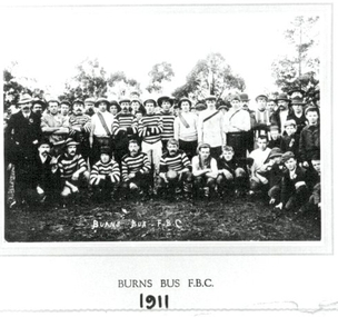 Clunes Museum
Photograph - PHOTOGRAPH FOOTBALL 1911, BURNS BUS 1911, 1911
PHOTOGRAPH KEPT AT CLUNES FOOTBALL CLUB.1 Black and white photograph of BURNS BUS FOOTBALL CLUB 1911 mounted on buff coloured cardboard .2 & .3 copies of the above photograph On reverse: Hand written pencil "Clunes Football Club"photography, football, burns bus f.b.c., football 1911 -
 St Patrick's Old Collegians Association (SPOCA)
Photograph - History, Prizes & Documents