-
 Glenelg Shire Council Cultural Collection
Administrative record - Ledger - Prescription Book, April 1931 - August 1932, 1931-1932
Local ChemistFront: n/a -
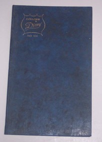 Ballarat Tramway Museum
Administrative record - Log book, Diary, Collins Bros, 1969
Yields information about the tramcar maintenance activities of the SEC at the depot in frequency of changing brake blocks, light bulbs, trolley rope and wheels for each tramcar.Collins Diary No. 324, blue Rexene covers, sewn sections with ruled sheets providing a diary for 1970, 7 days and notes for each double page. Has "useful information" sheets at from the diary. Used by the SEC Ballarat depot to record brake block changes and light globe replacements on each tramcar. Also gives details on trolley rope and trolley wheel replacements.tram, trams, sec, ballarat, depot, brake blocks, trolley wheels -
![Monnington [Estate], 1935](/media/collectors/550653872162f11fb04854aa/items/5907eb86d0ce0c14e82385c8/item-media/5907ecafd0ce0c14e823e87f/item-fit-380x285.jpg) Kew Historical Society Inc
Kew Historical Society IncPlan - Subdivision Plan, Monnington [Estate], 1935
Pru Sanderson, in her groundbreaking ‘City of Kew Urban Conservation Study : Volume 2 - Development History’ (1988), summarised the periods of urban development and subdivisions of land in Kew. The periods that she identified included 1845-1880, 1880-1893, 1893-1921, 1921-1933, 1933-1943, and Post-War Development. These periods were selected as they represented periods of rapid growth or decline in urban development. An obvious starting point for Sanderson’s groupings involved population growth and the associated economic cycles. These cycles also highlighted urban expansion onto land that was predominantly rural, although in other cases it represented the decline and breakup of large estates. A number of the plans in the Kew Historical Society’s collection can also be found in other collections, such as those of the State Library of Victoria and the Boroondara Library Service. A number are however unique to the collection.Subdivision plans are historically important documents used as evidence of the growth of suburbs in Australia. They frequently provide information about when the land was sold on which a built structure was subsequently constructed as well as evidence relating to surveyors and real estate and financial agents. The numerous subdivision plans in the Kew Historical Society's collection represent working documents, ranging from the initial sketches made in planning a subdivision to printed plans on which auctioneers or agents listed the prices for which individual lots were sold. In a number of cases, the reverse of a subdivision plan in the collection includes a photograph of a house that was also for sale by the agent. These photographs provide significant heritage information relating house design and decoration, fencing and household gardens.The first subdivision of Monnington took place in 1935. At that time, Monnington and 10 new allotments were offered for sale bordering Adeney and Marshall Avenues. In this subdivision plan, Monnington is one of 13 lots for sale. The subdivision created the irregular land holding of Monnington today. The excision of southwest corner of Monninton was caused by the need to have regular allotments facing the curve in Marshall Avenue.monnington - adeney avenue -- kew (vic.), subdivision plans -- kew (vic.) -
 Kew Historical Society Inc
Plan - Subdivision Plan, Wimba Estate, Kew, c.1925-c.1929, ca. 1925-ca. 1929
Pru Sanderson, in her groundbreaking ‘City of Kew Urban Conservation Study : Volume 2 - Development History’ (1988), summarised the periods of urban development and subdivisions of land in Kew. The periods that she identified included 1845-1880, 1880-1893, 1893-1921, 1921-1933, 1933-1943, and Post-War Development. These periods were selected as they represented periods of rapid growth or decline in urban development. An obvious starting point for Sanderson’s groupings involved population growth and the associated economic cycles. These cycles also highlighted urban expansion onto land that was predominantly rural, although in other cases it represented the decline and breakup of large estates. A number of the plans in the Kew Historical Society’s collection can also be found in other collections, such as those of the State Library of Victoria and the Boroondara Library Service. A number are however unique to the collection.Subdivision plans are historically important documents used as evidence of the growth of suburbs in Australia. They frequently provide information about when the land was sold on which a built structure was subsequently constructed as well as evidence relating to surveyors and real estate and financial agents. The numerous subdivision plans in the Kew Historical Society's collection represent working documents, ranging from the initial sketches made in planning a subdivision to printed plans on which auctioneers or agents listed the prices for which individual lots were sold. In a number of cases, the reverse of a subdivision plan in the collection includes a photograph of a house that was also for sale by the agent. These photographs provide significant heritage information relating house design and decoration, fencing and household gardens.In 1925, the City of Kew called for tenders for the construction of Wimba Avenue, Cadow Street and Lalla Street. Subsequent advertisements for the sale of land in Wimba Avenue continued from 1926 to 1929. The 18 lots (and a further five allotments on the eastern side of the street) offered for sale were unofficially described in the subdivision plan as the ‘Wimba Estate’. These lots began in Park Hill Road and extended almost to Cotham Road. The subdivision took its name from the house ‘Wimba’ in Cotham Road, which may have formed the southern boundary of the subdivision. (Wimba, at 235 Cotham Road was constructed between 1862-70). The Plan highlights the proximity and advantage of ‘electric’ trams in Cotham and Glenferrie Roads, and the Kew and Glenferrie Railway Stations. An oddity in the Plan is the reference to the electric tram terminus at Burke Road, given that the tramline had already been extended to Mont Albert in 1916.wimba estate, subdivision plans - kew, parkhill road – kew (vic.), normanby road – kew (vic.), wimba avenue – kew (vic.) -
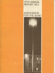 Vision Australia
Administrative record - Text, 78th Annual report 1973 Association for the Blind of Victoria, 1981
Articles in annual report include: President's report, finance report, auditor's report, balance sheet, nursing homes, social work, rehabilitation, low vision clinic, honorary services, auxiliary income, blind members, sport and recreation, life governors. There are reports on John Wicking taking on the President's role from Pat Lightfoot, increasing costs, opening of the Geelong Regional Day Centre and a training course developed for volunteers who do home visitation.1 printed volume with illustrationsassociation for the blind, annual reports, john wicking, h.m. lightfoot, barry farnsworth, patricia heath, john bright, edith lain, edith currell -
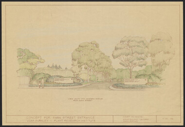 University of Melbourne, Burnley Campus Archives
Plan, Concept for Swan Street Entrance. VCAH Burnley - Plant Research Institute, 1988-1998
(1) Concept and Drawing by Steve Mullany, Lec turer V.C.A.H. Burnley 9 Dec 1988. Handdrawn. 1 coloured, 2 copies and 4 tracing paper sketches. (2) Landscape Plan by Steve Mullany 3 Feb 1989. Handdrawn. Includes Plant Plan. 2 copies on tracing paper. 3 copies original on paper with some additional notation. (30 Project Eden, Swan Street, Richmond - Landscape Plan LA2 Project No 682 by Mark McWha Pty Ltd Nov 1997. Photocopy. Includes Irrigation and Plant Schedule. (4) Swan St Frontage Planting Scheme by P. Tulk for AMRAD. Coloured. 19/2/1998. -
Glenelg Shire Council Cultural Collection
Administrative record - Rate Notice - Mr Campbell, Portland, 1942-1943
Rate Notice 1942 - 43, Portland Borough Council, Portland Waterworks Trust, Portland Sewerage Authority, dated 18 MAR 1943 for 57 Percy St Portland, owner / occupier Max Hector Campbellcampbell family records -
Glenelg Shire Council Cultural Collection
Administrative record - Cash Book - Formularies and Lectures of the Ancient Order of Foresters Friendly Society, c. 1870
Cash book, hard cover, black, bound in red leather. 'Cash Book' gold lettering on spine. Members contributions and expenses for Court Prosperity (Portland) No. 3195,, covering the period DEC 1870 - SEP 1884. -
University of Melbourne, Burnley Campus Archives
Administrative record - Register, Burnley Records, Letter Book, 05.06.1950-02.12.1963
mail, administration, answers to queries, general public questions -
Glenelg Shire Council Cultural Collection
Administrative record - Plans, n.d
Black and white photocopy of old plan of subdivision, same as 8398, 8399, smaller scale, numerous notations, added by Vanda Savill. -
 Bendigo Military Museum
Administrative record - I Fd Svy Sqn Monthly Report: Oct - Dec 1978, 1 Fd Svy Sqn, 1978
Report covering the activities of 1 Fd Svy Sqn between Oct 78 to Dec 78. Monthly Reports were mandatory for Royal Australian Survey Corps unitsPlastic, Cardboard covered, A4 Paper reports, diagrams. Pictorial Index at rear.royal australian survey corps, rasvy, fortuna, army survey regiment, army svy regt, asr -
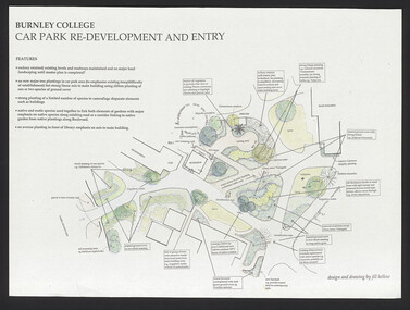 University of Melbourne, Burnley Campus Archives
Plan, Redevelopment of Old Car Park and Surrounds, 1993-1998
(1) Coloured plan, Concepts for discussion by Phil Tulk 27.11.97. (2) As above dated 15.5.98. (3) Coloured rough plan. (4) 1 tracing paper, 1 coloured paper copy and 2 copies, Burnley College Car Park Re-development and Entry by Jill Kellow. (5) Notes for discussion. (6) Site Plan VCAH Carpark Landscape Graphics Assignment No 1 by Ken Wallace, March 1993. Scale 1:100.jill kellow, phil tulk, ken wallace, vcah -
Clunes Museum
Map - CLUNES MAP SHOWING STREETS AND LOT NUMBERS
PURCHASED FROM DONORMAPS, PARISH OF CLUNES, CLUNES TOWNSHIPCLUNES TOWNSHIP AND STREETSlocal history, document, maps, clunes township -
 Bendigo Historical Society Inc.
Administrative record - Lands Office Bendigo - Residence area applications
Red hard cover book containing handwritten details of applications and renewals of residence area licenses. The first entry is dated 16-12-36 and the last entry is dated 09-03-66.White sticker on the front: RA Applications No. 3361 - 4382. Also, on the front in black texter the No. 3361. On the spine white sticker with No. 3361.land office, residence area licenses -
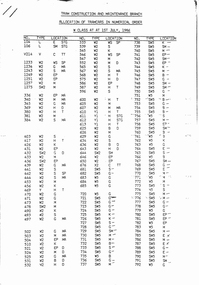 Melbourne Tram Museum
Administrative record - Depot List, The Met, "Tram Construction and Maintenance Branch - Allocation of Tramcars 1.7.1986", Jul. 1986
Depot List - 13 A4 sheets, were stapled in top left hand corner, titled "Tram Construction and Maintenance Branch - Allocation of Tramcars 1.7.1986" Sheets 1 to 6 - Allocation of Tramcars in Numerical Order including listing of tramcars for storage and disposal and storage and retention in operating condition to A 272 and artics 2002. Sheets 7 to 12 - allocation by depot including trams in storage at Hawthorn, Approved disposal, future disposal, training trams, tourist trams and special purpose, Ministry of Arts, Decorated trams, Reserve trams. Sheet 13 - Summary of Fleet in Service.trams, tramways, tramcars, mmtb, lists, depots, depot allocation -
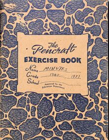 Ringwood and District Historical Society
Administrative record, East Ringwood Progress Association Minutes 1948 - 1951
Hand-written minutes of the East Ringwood Progress Association from 29 November 1948 to 25 June 1951 -
 Kew Historical Society Inc
Plan - Subdivision Plan, Jas R Mathers Son & McMillan, East Kew Tramway Estate, 1915
Pru Sanderson, in her groundbreaking ‘City of Kew Urban Conservation Study : Volume 2 - Development History’ (1988), summarised the periods of urban development and subdivisions of land in Kew. The periods that she identified included 1845-1880, 1880-1893, 1893-1921, 1921-1933, 1933-1943, and Post-War Development. These periods were selected as they represented periods of rapid growth or decline in urban development. An obvious starting point for Sanderson’s groupings involved population growth and the associated economic cycles. These cycles also highlighted urban expansion onto land that was predominantly rural, although in other cases it represented the decline and breakup of large estates. A number of the plans in the Kew Historical Society’s collection can also be found in other collections, such as those of the State Library of Victoria and the Boroondara Library Service. A number are however unique to the collection.The Kew Historical Society collection includes almost 100 subdivision plans pertaining to suburbs of the City of Melbourne. Most of these are of Kew, Kew East or Studley Park, although a smaller number are plans of Camberwell, Deepdene, Balwyn and Hawthorn. It is believed that the majority of the plans were gifted to the Society by persons connected with the real estate firm - J. R. Mathers and McMillan, 136 Cotham Road, Kew. The Plans in the collection are rarely in pristine form, being working plans on which the agent would write notes and record lots sold and the prices of these. The subdivision plans are historically significant examples of the growth of urban Melbourne from the beginning of the 20th Century up until the 1980s. A number of the plans are double-sided and often include a photograph on the reverse. A number of the latter are by noted photographers such as J.E. Barnes.The East Kew Tramway Estate was a subdivision of two separate parcels of land between Adeney Avenue and Normanby Road. The larger section included 54 lots facing Adeney Avenue, Argyle Road, and Campbell, Hunter and Wishart Streets. [Hunter and Wishart Streets were created as part of the subdivision.] A further 17 allotments faced Normanby Road, Hubert and Campbell Streets. [The name of Hubert Street was later to be changed to Cecil Street.] The promotion of the sale referred to the advantages of living between two tram routes, in High Street and Cotham Road. On the plan, quaintly drawn trams mark these routes. Also on the plan is the route of part of the Outer Circle [Railway] Line.east kew tramway estate, subdivision plans - east kew -
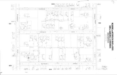 Camberwell Historical Society
Map (Item) - MMBW map, Melbourne and Metropolitan Board of Works, Melbourne and Metropolitan Board of Works - Shire of Boroondara and Camberwell - Detail Plan no. 1845, August 1904
Lithographer JEM, exd. JWD, June 1904, no. 71. 40P.15W.melbourne and metropolitan board of works, map, camberwell, cartography -
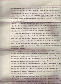
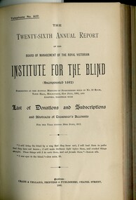 Vision Australia
Administrative record - Text, Royal Victorian Institute for the blind annual report 1893, 1892-1897
Gaining royal assent in 1892, the Victorian Asylum and School for the Blind changed it's name to the Royal Victorian Institute for the Blind. These bound volumes of annual reports contain the information sent to subscribers of the Institute and outline the notable events and difficulties facing the blind and the RVIB.1 bound volume with illustrations.royal victorian institute for the blind, annual reports -
Federation University Historical Collection
Plan, Barkly Street Campus, Ballarat East, c1950s ?
Ink on paper plan: Barkly Street Campus. plans, barkly street campus, ballarat east, ballarat girls', ballarat girls' secondary school -
 Vision Australia
Administrative record - Text, Care hire-purchase agreement between the Association for the Advancement of the Blind and J. W. Wilson 1953, November 18, 1953
This agreement between the Association for Advancement the Blind and J. W. Wilson, Secretary lays out the terms and conditions the hire-purchase of a motor vehicle at 16 pounds per month totalling 1039 pounds. The agreement is Dated 18th November 1953, and is signed and Sealed by members of the General Committee and J. W. Wilson. 5 pages of typed legal agreementassociation for the advancement of the blind, john wilson -
Stawell Historical Society Inc
Map, Special Surveys, District of Ararat, 1968
Special Surveys, District of Araratstawell -
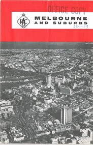 Melbourne Tram Museum
Map, Royal Automobile club of Victoria (RACv), "Melbourne and Suburbs", late 1960's
Map - folded 8 folds or sections, printed in two colours titled "Melbourne and Suburbs", published by the RACV late 1960's, giving a map of Melbourne and its suburbs, shows all tram and rail lines, highways, freeways under construction, has a detailed index and map of the city or CBD area, shows one way streets and churches, clubs etc.On front cover stamped "Office Copy" and hand written date of "28-1-69"trams, tramways, racv, melbourne, map, tramways, timetables -
Glenelg Shire Council Cultural Collection
Administrative record - Police Report - Criminal Offence Larceny, Heywood Victoria 1913, 15/08/1913
Hand written supplementary Police Report of Criminal Offence -larceny, Heywood police station, 15th Aug 1913 -
University of Melbourne, Burnley Campus Archives
Plan - Planting Design, Vireya Rhododendrons, 2015
vireya rhododendrons, garden plan, plant list -
Whitehorse Historical Society Inc.
Map, Shire of Blackburn and Mitcham, c1920
Map of the Shire of Blackburn and Mitcham (Sheet 2) with gas and sewered areas coloured.Map of the Shire of Blackburn and Mitcham (Sheet 2) with gas and sewered areas coloured. Scale 8 chains = 1 inch.Map of the Shire of Blackburn and Mitcham (Sheet 2) with gas and sewered areas coloured.shire of blackburn and mitcham, sewerage and sanitation, gas supply -
Port Melbourne Historical & Preservation Society
Plan - Drainage Improvements, Ross Street, Port Melbourne, Borough of Port Melbourne, 3 Nov 1892
Plan of Ross Street drainage improvement diversion drain, 1892.Signatures of J. J. Bartlett (Mayor), A. V. Heath (Borough Surveyor), W. Harrison, Laurence Brady (Contractor)engineering - canals and drainage, james john bartlett, arthur victor heath, town clerks, w harrison, laurence brady -
Glenelg Shire Council Cultural Collection
Administrative record - Cashbook - Ancient Order of Foresters, c. 1878
Cash book, hard cover, green marbled, brown leather binding. Members' contributions and expenses for Court The Hope (Portland), dating from 9 March 1878 - 24 Nov 1914 White label on cover '1878 - 1914'Back: inside back cover - small sketch map of the site of Foresters' Hall in Portland - black ink on white paper -
Whitehorse Historical Society Inc.
Map, before 1890
Early map showing location and areas of plots and their owners' names between Heatherdale Road in the east and Springvale Road in the west, Burwood Road to the south to north of Canterbury Road. Later additions to 1969Early map showing location and areas of plots and their owners' names between Heatherdale Road in the east and Springvale Road in the west, Burwood Road to the south to north of Canterbury Road. Later additions to 1969Early map showing location and areas of plots and their owners' names between Heatherdale Road in the east and Springvale Road in the west, Burwood Road to the south to north of Canterbury Road. Later additions to 1969mitcham, vermont, nunawading -
Whitehorse Historical Society Inc.
Map, Nunawading. County of Bourke, 1878
Photocopy of map of Shire of Nunawading.Photocopy of map of Shire of Nunawading. Note: Fosters v President of the Shire of Nunawading. On Verso: Copied from the most up to date by the Dept of Lands, 1878. Laid before the Executive Council, 11 June 1878. Shows land holders.Photocopy of map of Shire of Nunawading.shire of nunawading, maps