-
 Glenelg Shire Council Cultural Collection
Administrative record - Administrative record - Renewal receipt no 22389, fire insurance policy no. 1666241, from National Fire and Marine Insurance Company of New Zealand Limited, Portland Agency, n.d
Renewal receipt no 22389, fire insurance policy no. 1666241, from National Fire and Marine Insurance Company of New Zealand Limited, Portland Agency, to Committee of Management of Portland Free Public Library and Museum and Literary Institute (Inc.), for period 24 NOV 1918 - 24 NOV 1919 - White printed form, particulars in purple typeFront: '1616' black ink top right -
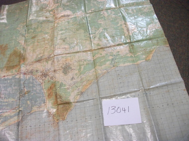 National Vietnam Veterans Museum (NVVM)
Map, Intelligence Map
Vinyl coated topographical map of part of Vietnam featuring main roads, towns and city locations current or ruined. River locations etc. Names all in Vietnamese language.map, vietnam -
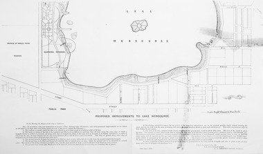 Friends of Ballarat Botanical Gardens History Group
Plan - Photocopy on paper, Proposed Improvements to Lake Wendouree, 22 April 1873
Photocopy on papermap, lake wendouree, ballarat city council -
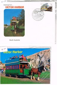 Melbourne Tram Museum
Administrative record - Envelope/s, Australia Post, "Victor Harbor", 1989
.1 - Postcard - Victor Harbor horse drawn tram on Granite Island, VH51, with the Adelaide horse tram stamp, 41c on the rear and with a cancellation stamp - Victor Harbor SA 5211, cancellation stamp, dated 11 Oct. 1989. Card printed by Prestige Souvenirs Adelaide. Wrapped in a thin plastic cover. .2 - Envelope - Greetings from Victor Harbor, with a photo of the horse tram on the front, with the Adelaide horse tram stamp, 41c with a cancellation stamp - Victor Harbor SA 5211, cancellation stamp, dated 11 Oct. 1989. Wrapped in a thin plastic cover.Both items have a $1.50 price sticker in the top left hand corner.trams, tramways, stamps, australia post, victor harbor -
Bendigo Historical Society Inc.
Map - DIGGORRA, 26/04/1880
Map: Diggorra, County of Bendigo. Parish plan ( number 237 in Map Cupboard 1)map, bendigo, parish plan, diggorra -
Moorabbin Air Museum
Administrative record (item) - CAC Records Relating to the Production of the Rolls Royce Nene Engine, "Nene" Engine Project
-
Port Melbourne Historical & Preservation Society
Plan - Water cart used in road construction, Borough of Sandridge, 21 Nov 1870
From a group of maps and plans not required by the Port Melbourne Council Engineering Department in May 1994 and offered at that time to the Port Melbourne Historical Society.Plan of water cart used in road construction including 4 diagrams and scales: signed by Borough Surveyor, Nov 21 1870.built environment - civic, engineering, engineering department - borough of sandridge -
Bendigo Historical Society Inc.
Map - KIMBOLTON, 20/12/1907
Map: Parish of Kimbolton, County of Bendigo. Parish plan. (number 339 in map cupboard 1)map, bendigo, parish plan, kimbolton -
 Kew Historical Society Inc
Plan, Melbourne & Metropolitan Board of Works / Borough of Kew, Detail Plan No.1593, 1905
The Melbourne and Metropolitan Board of Works (MMBW) plans were produced from the 1890s to the 1950s. They were crucial to the design and development of Melbourne's sewerage and drainage system. The plans, at a scale of 40 feet to 1 inch (1:480), provide a detailed historical record of Melbourne streetscapes and environmental features. Each plan covers one or two street blocks (roughly six streets), showing details of buildings, including garden layouts and ownership boundaries, and features such as laneways, drains, bridges, parks, municipal boundaries and other prominent landmarks as they existed at the time each plan was produced. (Source: State Library of Victoria)This plan forms part of a large group of MMBW plans and maps that was donated to the Society by the Mr Poulter, City Engineer of the City of Kew in 1989. Within this collection, thirty-five hand-coloured plans, backed with linen, are of statewide significance as they include annotations that provide details of construction materials used in buildings in the first decade of the 20th century as well as additional information about land ownership and usage. The copies in the Public Record Office Victoria and the State Library of Victoria are monochrome versions which do not denote building materials so that the maps in this collection are invaluable and unique tools for researchers and heritage consultants. A number of the plans are not held in the collection of the State Library of Victoria so they have the additional attribute of rarity.Original survey plan, issued by the MMBW to a contractor with responsibility for constructing sewers in the area identified on the plan within the Borough of Kew. The plan was at some stage hand-coloured, possibly by the contractor, but more likely by officers working in the Engineering Department of the Borough and later Town, then City of Kew. The hand-coloured sections of buildings on the plan were used to denote masonry or brick constructions (pink), weatherboard constructions (yellow), and public buildings (grey). The laborious task of hand-tinting these Board of Works plans was not without hazards as is evidenced by Plan No. 1593. On the Plan, the original colourist spilt black and green ink, partially obscuring some parts. The most obvious casualty is ‘Clifton’ located on the corner of Cotham Road and Park Street [now Adeney Avenue]. Included in this Plan, and outlined in pink is that part of the section that the contracting engineer was tasked with completing. This included sewering on both sides of this part of Cotham Road, but excluded properties such as ‘Glendonald’ and ‘Monnington’. This area was to undergo a series of subdivisions including the ‘Clifton Estate’, which created housing lots on Adeney Avenue and Florence Avenue in 1916. The most notable occupant of Clifton was William Adeney [died 1893], a pioneer of Camperdown, after which Park Street was later renamed.melbourne and metropolitan board of works, detail plans, survey plans - borough of kew, mmbw 1593, cartography -
University of Melbourne, Burnley Campus Archives
Administrative record, Accommodation - BHC, 1942-1963
t h kneen, administration building, accommodation -
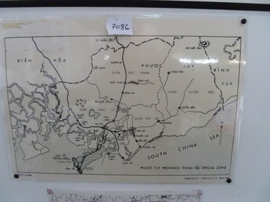 National Vietnam Veterans Museum (NVVM)
Map, Map of Phuoc Tuy Province - Vung Tau Special Zone, 1/05/1968 12:00:00 AM
Laminated map of Phuoc Tuy Province - Vung Tau special zone. Oulne of hamlets and military bases.AFV/F7-12/1188map, vung tau, 1 atf, 1 alsg -
 University of Melbourne, Burnley Campus Archives
Plan, Steve Mullany, Classroom Quadrangle/Library Courtyard, 1985-1999
Various plans. (1) Photocopy of Section A-A, 1985 and 1 photocopy of part of plan. (2) Tracing paper copy, Construction Plan Classroom/Library Quadrangle Feb. 1986. (3) Master Plan, coloured and detailed and 1 copy not detailed, Classroom Quadrangle Landscape Redevelopment by S. Mullany, 10 August 1988. (4) 4 tracing paper and 2 paper copies Set of Plans Library Courtyard Aug 1992 by KW. (5) Miscellaneous sketches. (6) Assessment task. (7) Sketch Proposal Quad Entry by M. Green May 1995. (8) Quadrangle Steps Redevelopment 7/12/99 by Phil Tulk. (9) Tracing paper and paper copies Quadrangle Steps Redevelopment by JK 20.12.99.classroom, library, courtyard, steve mullany -
Bendigo Historical Society Inc.
Map - MEMSIE ESTATE, 26/08/1905
Map:Plan of Memsie estate, aquired under Closer Settlement Act 1904. Parish plan. Map dated 26/08/1905.map, estate, memsie estate, closer settlement act 1904. -
Whitehorse Historical Society Inc.
Map, Ringwood, 1935
Australia Ringwood and area map.Australia1:63,360 series map, Ringwood N.849 Zone 7. Scale 1 inch to 1 mile. Approximate scope: Prahran-Cockatoo, Lilydale-DandenongAustralia Ringwood and area map.maps, ringwood -
 Melbourne Tram Museum
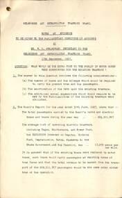
Administrative record - Notes of Evidence - Strangward re bus replacement, Melbourne & Metropolitan Tramways Board (MMTB), 9/1927
Transcript of Evidence given to the Parliamentary Committee of Accounts by Mr W O Strangward, Secretary to the MMTB 13/9/1927 - in response to the question "What would be the extra cost to the public if motor buses were substituted for the existing tramways?" Looks at Fare Revenue, operating cost per vehicle mile, relative average speeds, number of tram and bus miles required to carry 224,000,000 passengers, standing passengers and capacity. Notes that 2.25 buses would be required to replace each existing tramcar. Examines Annual Operating cost for both forms, capital outlay including provision for spares, amortization of the present tramway debt and cost of roads. Has a financial summary showing the additional cost would be 1.878,500 pounds to run buses requiriing a fare increase of 75%. Conclusions also note that there is a place for buses on light routes, petrol or diesel production in Australia and accidents.Yields information about the cost of running buses in Melbourne instead of trams based on 1927 information.Set of nine duplicated foolscap sheets secured by a foldable brass clip in top left hand corner.trams, tramways, bus replacement, buses, parliament, evidence, mr strangward, costs -
 Kew Historical Society Inc
Plan - Subdivision Plan, Warne Estate, Undated
Pru Sanderson, in her groundbreaking ‘City of Kew Urban Conservation Study : Volume 2 - Development History’ (1988), summarised the periods of urban development and subdivisions of land in Kew. The periods that she identified included 1845-1880, 1880-1893, 1893-1921, 1921-1933, 1933-1943, and Post-War Development. These periods were selected as they represented periods of rapid growth or decline in urban development. An obvious starting point for Sanderson’s groupings involved population growth and the associated economic cycles. These cycles also highlighted urban expansion onto land that was predominantly rural, although in other cases it represented the decline and breakup of large estates. A number of the plans in the Kew Historical Society’s collection can also be found in other collections, such as those of the State Library of Victoria and the Boroondara Library Service. A number are however unique to the collection.The Kew Historical Society collection includes almost 100 subdivision plans pertaining to suburbs of the City of Melbourne. Most of these are of Kew, Kew East or Studley Park, although a smaller number are plans of Camberwell, Deepdene, Balwyn and Hawthorn. It is believed that the majority of the plans were gifted to the Society by persons connected with the real estate firm - J. R. Mathers and McMillan, 136 Cotham Road, Kew. The Plans in the collection are rarely in pristine form, being working plans on which the agent would write notes and record lots sold and the prices of these. The subdivision plans are historically significant examples of the growth of urban Melbourne from the beginning of the 20th Century up until the 1980s. A number of the plans are double-sided and often include a photograph on the reverse. A number of the latter are by noted photographers such as J.E. Barnes.The Warne Estate included four lots in Argyle Street, Kew. It represents a typical small-scale subdivision in this area. The lots for sale must have been further divided as there are now more houses in the street than there were blocks advertised in the subdivision. The agent left the proximity of the Outer Circle Railway off the plan. The Railway would have run along the triangular shaped lot 4. Lot 4 was offered for the sum of £600 plus the costs of footpath construction.subdivision plans - kew, warne estate -
 Bendigo Historical Society Inc.
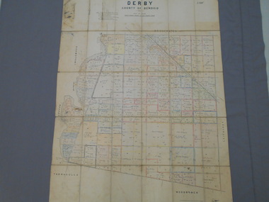
Map - JACK FLYNN COLLECTION: DERBY, 12/05/1892
Map: Derby, County of Bendigo. Parish plan.Department of Lands and Survey Melbourne by T.F.McGauran, 12.5.92map, bendigo, parish plan, derby -
 Vision Australia
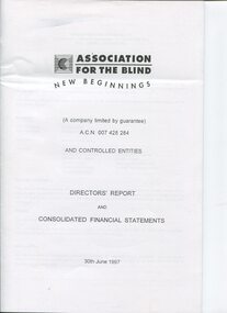
Administrative record - Text, Association for the Blind Financial Statements 30th June 1997
Financial information for the Association for the Blind, presented as an appendix to the annual report of the institution.1 volume of printed pages with financial informationassociation for the blind, annual reports -
 Vision Australia
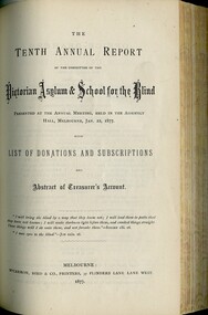
Administrative record - Text, Victorian asylum and school for the blind annual report 1876, 1867-1891
Annual reports were both a way of informing benefactors as well as generating new ones for charitable organisations. In 1867 an asylum and school for blind children began in Melbourne. Between that first intake and 1891, the asylum went through a great many changes, including the building of the St Kilda Road building, growing in size and developing a workshop for blind workers. 1 bound volume with illustrations.royal victorian institute for the blind, annual reports -
 Vision Australia
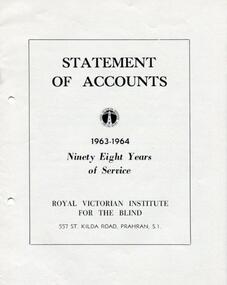
Administrative record - Text, RVIB Statement of Accounts 1963-1964
Financial information for the Royal Victorian Institute for the Blind, presented as an appendix to the annual report of the institution.1 printed volume of financial information for the RVIBroyal victorian institute for the blind, annual reports -
 Bendigo Historical Society Inc.
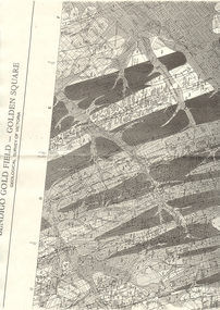
Map - LONG GULLY HISTORY GROUP COLLECTION: BENDIGO GOLD FIELD - GOLDEN SQUARE GEOLOGICAL SURVEY OF VICTORIA
Part of a map of the Bendigo Gold Field - Golden Square. Geological Survey of Victoria. Shown are reefs, faults and anticlines. Many of the mines are shown on the map. Gullies, hills and streets are also shown.bendigo, history, long gully history group, the long gully history group - bendigo gold field - golden square geological survey of victoria, north bendigo state school reserve, hospital reserve, benevolent asylum reserve, empire hill, richmond hill, raes hill, south end hill, victoria hill, new chum hill, iron bark hill, redan hill, view hill, hustlers hill, camp hill -
 Bendigo Military Museum
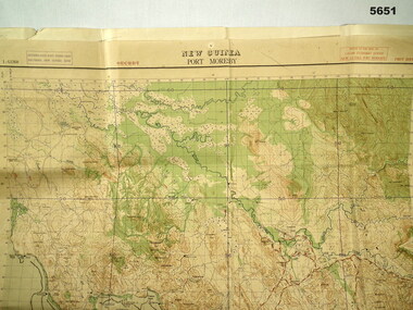
Map - MAP, PORT MORESBY 1943, 2/1st Aust Army TOPO SVY Coy, March 1943
In the collection re Capt R.A. Hanson VX111070, refer cat No 5646.3P for his service details.Map, Port Moresby area, colour, detailed, scale 1" - 1 mile, first Edition.In red, "1:63360 Standard series New Guinea, Port Moresby"map, new guinea, port moresby -
Creswick Campus Historical Collection - University of Melbourne
Administrative record - VSF Student examination records, Board of Forestry Education et al
Examination results - unsortedDocuments -
Canterbury History Group
Map - Map of Canterbury, Surrey Hills, Mont Albert and Camberwell, c1930s
Map produced and distributed by White & Clarke Real Estate Agents in Canterbury c 1930canterbury, canterbury road, surrey hills, mont albert, camberwell, maps, real estate agents -
 Kew Historical Society Inc
Plan, Sydney Arnold Best & Co, Field Place, Kew, c.1929
Pru Sanderson, in her groundbreaking ‘City of Kew Urban Conservation Study : Volume 2 - Development History’ (1988), summarised the periods of urban development and subdivisions of land in Kew. The periods that she identified included 1845-1880, 1880-1893, 1893-1921, 1921-1933, 1933-1943, and Post-War Development. These periods were selected as they represented periods of rapid growth or decline in urban development. An obvious starting point for Sanderson’s groupings involved population growth and the associated economic cycles. These cycles also highlighted urban expansion onto land that was predominantly rural, although in other cases it represented the decline and breakup of large estates. A number of the plans in the Kew Historical Society’s collection can also be found in other collections, such as those of the State Library of Victoria and the Boroondara Library Service. A number are however unique to the collection.The Kew Historical Society collection includes almost 100 subdivision plans pertaining to suburbs of the City of Melbourne. Most of these are of Kew, Kew East or Studley Park, although a smaller number are plans of Camberwell, Deepdene, Balwyn and Hawthorn. It is believed that the majority of the plans were gifted to the Society by persons connected with the real estate firm - J. R. Mathers and McMillan, 136 Cotham Road, Kew. The Plans in the collection are rarely in pristine form, being working plans on which the agent would write notes and record lots sold and the prices of these. The subdivision plans are historically significant examples of the growth of urban Melbourne from the beginning of the 20th Century up until the 1980s. A number of the plans are double-sided and often include a photograph on the reverse. A number of the latter are by noted photographers such as J.E. Barnes.An unnamed subdivision in Studley Park including five lots for sale in Studley Park Road, Highfield Grove and Tara Avenue. Unidentified on the plan, but clearly existing, are the Henty family mansion of Field Place and Tara Hall in Studley Park Road. The first attempted subdivision of Tara Hall was advertised in 1927 in which Lots 5, 6 and 7 in this plan were also advertised. Unusually, Lot 2 in Studley Park Road was created from the northern part of the Henty mansion, rather than Tara Hall. In the subdivision, lots were advertised at varying prices, with the highest price for land being Lot 2 in Studley Park Road. The plan notes that only one villa is to be allowed on each allotment.subdivision plans - kew, field place subdivision -- studley park – kew (vic.), highfield grove – kew (vic.), tara avenue – kew (vic.) -
 Kew Historical Society Inc
Plan, Melbourne and Metropolitan Board of Works, Borough of Kew : Detail Plan No.1562, 1905
The Melbourne and Metropolitan Board of Works (MMBW) plans were produced from the 1890s to the 1950s. They were crucial to the design and development of Melbourne's sewerage and drainage system. The plans, at a scale of 40 feet to 1 inch (1:480), provide a detailed historical record of Melbourne streetscapes and environmental features. Each plan covers one or two street blocks (roughly six streets), showing details of buildings, including garden layouts and ownership boundaries, and features such as laneways, drains, bridges, parks, municipal boundaries and other prominent landmarks as they existed at the time each plan was produced. (Source: State Library of Victoria). This plan forms part of a large group of MMBW plans and maps that was donated to the Society by the Mr Poulter, City Engineer of the City of Kew in 1989. Within this collection, thirty-five hand-coloured plans, backed with linen, are of statewide significance as they include annotations that provide details of construction materials used in buildings in the first decade of the 20th century as well as additional information about land ownership and usage. The copies in the Public Record Office Victoria and the State Library of Victoria are monochrome versions which do not denote building materials so that the maps in this collection are invaluable and unique tools for researchers and heritage consultants. A number of the plans are not held in the collection of the State Library of Victoria so they have the additional attribute of rarity.Original survey plan, issued by the MMBW to a contractor with responsibility for constructing sewers in the area identified on the plan within the Borough of Kew. The plan was at some stage hand-coloured, possibly by the contractor, but more likely by officers working in the Engineering Department of the Borough and later Town, then City of Kew. The hand-coloured sections of buildings on the plan were used to denote masonry or brick constructions (pink), weatherboard constructions (yellow), and public buildings (grey). MMBW detail plan No.1562, in contrast to No.1561 includes the names of a large number of houses: in Barkers Road: ‘Ashwick’, ‘Owasso’, ‘Anadiha’, ‘Eurobin’, ‘Carlsruhe’, ‘Arlington’ and ‘Altyre’. Unnamed but clearly represented on the plan is what was then known as the ‘Auburn Heights Recreation Club’, which at this stage included a Bowling Green, a Croquet Green and two Tennis Courts. On the plan, Brougham Place, as it was then known, is represented. It was later renamed Daniell Place. The aforementioned Arlington is now the junior campus of Preshil. melbourne and metropolitan board of works, detail plans, mmbw 1562, cartography -
Port Melbourne Historical & Preservation Society
Plan - Setting temporary gangway at Inner East berth Station Pier for Tasmanian ferry Abel Tasman, Engineering Division, Port of Melbourne Authority, 1984
Plan: cross section at passenger doors showing deck levels - ship full lowest allowable tide (Drawing used in the setting up of temporary gangway at the Inner East berth of Station Pier for the vessel Abel Tasman), 1984melbourne harbor trust - port of melbourne authority, piers and wharves - station pier, abel tasman -
 Old Colonists' Association of Ballarat Inc.
Plan, Old Colonists' Association Proposed New Cottages Nos 1, 2, 3, 4, c1924
Blueline plan of the early cottages built for the Old COlonists' Association of Ballarat.old colonists' association ballarat, charles anderson grove, retirement village, old colonists' association ballarat cottages, cottage 1, cottage 2, cottage 3 -
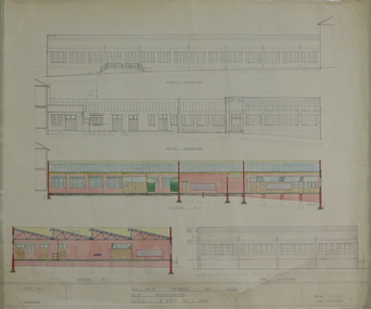 Federation University Historical Collection
Plan, Ballarat School of Mines New Workshops, 17/11/1944
Hand drawn planballarat school of mines, new workshops, albert street -
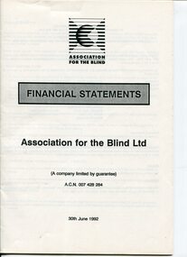 Vision Australia
Administrative record - Text, Association for the Blind Financial Statements 30th June 1992
Financial information for the Association for the Blind, presented as an appendix to the annual report of the institution.1 volume of printed pages with financial informationassociation for the blind, annual reports