-
 Moorabbin Air Museum
Manual (Item) - Type A-3 Automatic Pilot Instructions B-25 Mitchell Repair Instructions C131 D/E USAF Series Flight Manual
Commonwealth Aircraft Corporation Library -
Whitehorse Historical Society Inc.
Legal record - Land Title, Musk Street, Blackburn
Land Titles referring to No. 1 Musk Street, BlackburnLand Titles referring to No. 1 Musk Street, Blackburn : 1. Vol. 542 Fol. 108222, James William Barnes, 1872; 2. Vol. 1877, Fol. 375367, Freehold Investment and Banking Company of Australia Limited, 1886; 3. Transfer 1507851 to John Thomas Williams, 1932; 4. Vol. 8109 Fol. 997 William Henry Rogers, 1955, with Plan of Subdivision CP 21670; 5. cadastral map, AMA zone 55, Sep 2000.Land Titles referring to No. 1 Musk Street, Blackburn musk street, blackburn, no. 1, maple street, blackburn, lawson street, blackburn, elder street, blackburn, barnes, james william, freehold investment and banking company of australia ltd, springfield road, blackburn, whitehorse road, blackburn, barnes estate -
 Melbourne Tram Museum
Administrative record - Depot List, Public Transport Corporation (PTC), "Tramcar Fleet Depot Allocation", 19-2-1993 to 16-10-1996
Bound folder - A4 sheets - clear plastic cover, black rear card cover, comb bound, containing the location of tramcars Tram fleet allocations from 19-2-1993 to 16-10-1996 bound in reverse date order. Gives tramcars for Brunswick, Camberwell, Glenhuntly, Kew, Essendon, Sth Melbourne, Malvern and Preston Workshops and totals for depots and type or class of tramcars. Prepared by the PTC.trams, tramways, tramcars, depot allocation, lists, public transport corporation, ptc, depots -
Moorabbin Air Museum
Manual (Item) - Engineering Manual For The Royal Air Force .Air Publication No. 1464A Volume 1
-
 Vision Australia
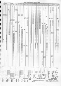
Administrative record - Text, Sports Ground & Club House for Blind Trustees Account, 30/11/1939
Statement of Receipts and Expenditure for the Sports Ground and Club House for the Blind at Kooyong for the year ending 30th September 1939 and the liabilities of the trustees (W. Paterson, B. Goold, H. Lightfoot) being advances not bearing interest.2 typewritten sheets of financial informationassociation for the advancement of the blind, william paterson, kooyong club house -
 Kew Historical Society Inc
Map, Real Estate Map of Bulleen, Templestowe, Lower Templestowe, Doncaster, North Balwyn
A large undated printed map of Bulleen, Templestowe, Lower Templestowe, Doncaster, North Balwyn showing major and minor roads, waterways and proposed facilities in this area of Melbourne.A useful if undated real estate map that allows viewers to compare current and historic aspects of these areasMap of Bulleen, Templestowe, Lower Templestowe, Doncaster, North Balwyn used by JB Thomson & Co, Real Estate Agents, to identify and record land sales on these. There are some markings on the plan indicating the location and price of lots.subdivision plans, bulleen, templestowe, lower templestowe, doncaster, north balwyn -
Moorabbin Air Museum
Manual (Item) - Bell Helicopter Component Repair And Overhaul Manual Volume 1 For Bell Model 206B3
-
Glenelg Shire Council Cultural Collection
Plan - Ship Plan / Mould, n.d
Wooden pattern for mould for boat fitting. Rectangular base; round shaped piece attached to top, painted orange.Back: '6 OFF' - black texta '169' - pencil -
Moorabbin Air Museum
Manual (Item) - Airtrainer Ct-4A Flight Manual
-
 Federation University Historical Collection
Plan, Ballarat School of Mines E.J. Tippett Learning Resource Centre Signs, 19/05/1986
Plans for signage of the Ballarat Sxhool of Mine Library - The E.J. Tippett Learning Resource Centre. Includes front elevation of building. plan, tippett library, e.j. tippett library, e.j. tippett learning resource centre, gadsden signs, ballarat schoo of mines -
Moorabbin Air Museum
Manual (Item) - Ansett DC3 Daily inspection check list
-
Moorabbin Air Museum
Administrative record (item) - RAAF Wirraway Aircraft Servicing And Maintenance Form E/E.77 Travel Copy - A20-733, Royal Australian Air Force, Travel Copy: Aeroplane Maintenance Form E/E. 77, 09/10/57
Contains daily inspection and test flight records. Maintenance conducted at Maintenance Squadron, RAAF East Sale, Victoria. -
Moorabbin Air Museum
Manual (item) - General Dynamics F-111 Maintenance, RAAF Scheduled Inspection and Maintenance Requirements (USAF Phase Philosophy) F111G & FB111A
RAAF -
 Nhill Aviation Heritage Centre
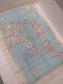
Map - Silk Map, No. 24 south celebes, c1942
Silk maps produced by the USA for the Pacific warWhite woven silk material with printed map and text North Celebes print on the reverse side South CelebesNo. 24 South Celebesusa, us army air force, silk, map, celebes, saam, -
National Vietnam Veterans Museum (NVVM)
Manual, Inverter type, 103, 103A, 103B, S3101 Series (Rotax)
royal australian airforce - manuals -
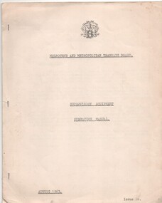 Melbourne Tram Museum
Manual, Melbourne & Metropolitan Tramways Board (MMTB), "Supervisory Equipment Operation Manual", Aug. 1963
Manual or instruction book - 11 duplicated quarto sheets stapled on left hand edge, titled "Supervisory Equipment Operation Manual". Has the MMTB logo and name on the top of the first sheet. Describes the supervisory control system for the MMTB sub-stations and associated equipment, includes a photograph of the control panel, list of the substations, facilities, the control system, the management of the substations and the principles of operation.trams, tramways, mmtb, substation, electrical systems, electric traction, carlton -
Glenelg Shire Council Cultural Collection
Plan - Ship Plan / Mould, n.d
Wooden pattern for mould for boat fitting. Two similar rectangular pieces joined in parallel by two small, similar rectangular pieces, at right angles to the larger rectangles, creating an open box-like shape. Painted white. -
Port Melbourne Historical & Preservation Society
Plan - Setting temporary gangway at Inner East berth Station Pier for Tasmanian ferry Abel Tasman, Engineering Division, Port of Melbourne Authority, 1984
Plan: cross section at passenger doors showing deck levels - ship full lowest allowable tide (Drawing used in the setting up of temporary gangway at the Inner East berth of Station Pier for the vessel Abel Tasman), 1984melbourne harbor trust - port of melbourne authority, piers and wharves - station pier, abel tasman -
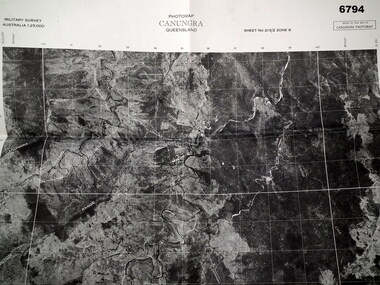 Bendigo Military Museum
Map - MAP, CUNUNGRA, QLD, Royal Aust. Survey Corps, 1955
Canungra was the Jungle Warfare Training Centre (JTC) before and including 1968. Item in the collection re Lt.Col. Swatton refer Cat No 6719.2P for his service details.This is a full size air photo map. It is black and white. Some natural features are labelled with white printing. The air photo has a white border of approx 6.5 cms size. Map information is printed in black ink around all four borders.Map data = Military survey Australia 1:25,999 Sheet No. 213/2 Zone 8. Scale 1:25,000. Date = The air photo was taken Jan 1955. Map produced by R.A. Survey Corps 1955.passchendaele barracks trust, survey map -
University of Melbourne, Burnley Campus Archives
Administrative record - Timetable, Bachelor of Applied Science (Horticulture)
timetable, students -
Moorabbin Air Museum
Plan (Item) - Plan Fletcher FU-24
-
Moorabbin Air Museum
Manual (item) - Trans-Australia Airlines Airframe Training Manual Electra Aircraft for Lockheed 188A Aircraft, Trans-Australia Airlines Airframe Training Manual Electra Aircraft
-
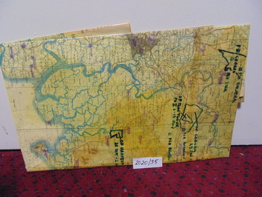 National Vietnam Veterans Museum (NVVM)
Map
A large laminated coloured map of Joint Operations Graphic (ground), Vietnam. there are specific information highlighted in pen.3rar, mcphail collection, map -
Moorabbin Air Museum
Manual (item) - Nomad N22/N22A series Maintenance Manual Vol B2 - RAAF
-
Moorabbin Air Museum
Manual (item) - Nomad Searchmaster Familiarization Manual
-
Moorabbin Air Museum
Manual (item) - Twin Wasp R1830 Engine Overhaul instruction Manual
-
Moorabbin Air Museum
Manual (Item) - Atar Engine Descriptive And Functional Handbook - Plates
RAAF -
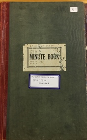 Kew Historical Society Inc
Administrative record, Auburn Heights Recreation Club, Minute Book, 1926-1930
Sports Clubs in Kew in the final decades of the 19th century and in the early 20th century were often umbrella organisations with facilities for a number of sports. Typically in Kew, this included teams in lawn bowls, tennis and croquet. The Kew Bowling Club was formed in 1880 while the privately owned Auburn Heights Recreation Club was opened in 1904. By 1998, the two Clubs decided to amalgamate at the Auburn Heights site in Barkers Road, forming the Kew Heights Sports Club. The combined club was itself taken over by the Melbourne Cricket Club in 2012 becoming MCC Kew Sports Club. In 2017 MCC Kew closed and its landholding was subsequently sold to Carey Baptist Grammar School. Both the Kew and Auburn Heights Clubs assembled important collections. These historically significant and large collections were donated to the Society in 2020. The collections include manuscripts, pictures, trophies, plans, honour boards etc. References Barnard FGA 1910, 'Sports and Pastimes' in Jubilee History of Kew Victoria: Its origin & progress 1803-1910. Chapman J & C 1999, The history of the Auburn Heights Recreation Club, 1904 to 1908. Reeve S 2012, City of Boroondara: Thematic Environmental History, p.216.The combined collections of the four sporting clubs making up the collection number hundreds of items that are historically significant locally. They are also significant to the sporting history of the greater Melbourne area and to the sports of lawn bowls and tennis in Australia in the 19th and 20th centuries. The collection illuminates two of the Victorian historic themes - 'Building community life' through forming community organisations and 'Shaping cultural and creative life' by participating in sport and recreation.Auburn Heights Recreation Club's Minute Book for the years 1926 to 1930. [The item forms part of the large historic Auburn Heights Recreation Club collection, with items relating to the sports of lawn bowls, tennis and croquet, gifted to the Kew Historical Society in 2020].clubs - lawn bowls - kew (vic), auburn heights recreation club - barkers road - kew (vic) -
 Kew Historical Society Inc
Plan, Melbourne & Metropolitan Board of Works : Borough of Kew : Detail Plan No.1297, 1904
The Melbourne and Metropolitan Board of Works (MMBW) plans were produced from the 1890s to the 1950s. They were crucial to the design and development of Melbourne's sewerage and drainage system. The plans, at a scale of 40 feet to 1 inch (1:480), provide a detailed historical record of Melbourne streetscapes and environmental features. Each plan covers one or two street blocks (roughly six streets), showing details of buildings, including garden layouts and ownership boundaries, and features such as laneways, drains, bridges, parks, municipal boundaries and other prominent landmarks as they existed at the time each plan was produced. (Source: State Library of Victoria)This plan forms part of a large group of MMBW plans and maps that was donated to the Society by the Mr Poulter, City Engineer of the City of Kew in 1989. Within this collection, thirty-five hand-coloured plans, backed with linen, are of statewide significance as they include annotations that provide details of construction materials used in buildings in the first decade of the 20th century as well as additional information about land ownership and usage. The copies in the Public Record Office Victoria and the State Library of Victoria are monochrome versions which do not denote building materials so that the maps in this collection are invaluable and unique tools for researchers and heritage consultants. A number of the plans are not held in the collection of the State Library of Victoria so they have the additional attribute of rarity.Original survey plan, issued by the MMBW to a sewage contractor with responsibility for constructing sewers in the area identified on the plan within the Borough of Kew. The plan was at some stage hand-coloured, possibly by the contractor, but more likely by officers working in the Engineering Department of the Borough and later Town, then City of Kew. The hand-coloured sections of buildings on the plan were used to denote masonry or brick constructions (pink), weatherboard constructions (yellow), and public buildings (grey). This plan of Kew encompasses the area bounded by Barkers Road, High Street and Stevenson Street. Because of the angle created by High Street, a number of houses on the northern side of High Street are shown. The area is dominated by one of the great original landholdings in Kew, described here as the ‘Findon Paddock’. ‘Findon’, the house from which the name of the paddock was taken fronts Stevenson Street and was clearly a rambling structure. The best-known occupant of Findon was Henry ‘Money Miller’ who bought the house in 1871. Miller was a member of Victoria’s first parliament and assisted in the framing of its constitution. Findon was to be subdivided as early as 1912, when the Findon Subdivision was advertised to be sold by auction. In the plan of the subdivision, the original house is not shown, so, presumably it had previously been demolished. Fincham & Son moved the organ, built by Henry Willis, which was installed in the house, first to ‘Whernside’ in Toorak, and later to the Box Hill Methodist Church.melbourne and metropolitan board of works, detail plans, mmbw 1297, cartography, kew (vic.) — municipal collection -
Moorabbin Air Museum
Manual (Item) - Bristol Sleeve Valve Engines and Power Plant Spare Parts Price Lists