-
 Bendigo Historical Society Inc.
Map - NEW CHUM LINE, 1875
Plan: Longtitudinal Section of the Northern Section of the New Chum Line of Reef. Compilation consisting of smaller sections stapled togethermap, new chum line, gold mines, new chum line of reef -
 Ballarat Tramway Museum
Negative - Set of 3, Campbell Duncan, 2/07/1971 12:00:00 AM
Yields information about tram operations and the street views in Wendouree Parade near Gardens Loop and signage at the Loop.Set of 3 photographs taken on 28/2/1971 by Campbell Duncan of trams in Wendouree Parade at the Gardens .1 - No. 34 departing Gardens Loop to Mt Pleasant, with the Kiosk in the background. .2 - ditto and a very quiet road. .3 - Tram stop signs at Gardens Loop. See also Reg Item 6696 for the photo of the tram arriving at the loop.trams, tramways, wendouree parade, gardens loop, tram 34 -
 Eltham District Historical Society Inc
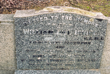
Negative - Photograph, Harry Gilham, Grave of William Hill and Agnes Somerville Irvine and family, Eltham Cemetery, Victoria, 1 Aug 2007
William Hill Irvine was born 6 July, 1858 in Newry, County Down, Ireland. He arrived in Melbourne December 1879 and taught at Geelong College. He was admitted to the Supreme Court in 1884 having qualified from Melbourne University and practiced in Melbourne. In 1891 he married Agnes Somerville Wanliss and they had one son, William Mitchell (1901 Armadale) and two daughters, Beatrice Wanliss (1899 Armadale) and Agnes Somerville Wanliss (1903 Armadale). Sir William Irvine sat in the Victorian Parliament (as Liberal Member for Lowan) from 1894 to 1906 and was Premier of Victoria from 1902 to 1904. He then switched to Federal politics and sat in the Commonwealth Parliament (as Liberal Member for Flinders) from 1906 to 1918. He was considered a potential Prime Minister, but his abrupt manner and hard-line conservatism (particularly his attitude to a railway strike) made him unacceptable even to many Liberals: he was known in Parliament as "Iceberg Irvine". He lived at Richmond, but in 1908 purchased land in Laughing Waters Road at Eltham, where he built the house ‘Killeavey’, initially as a weekend retreat. The site, a peninsula surrounded on three sides by the Yarra River, is of geological importance and has considerable cultural significance to the Wurundjeri. In 1912 Sir William moved to Killeavey and in 1913 purchased more land, extending his property to Reynolds Road. In 1923 he shifted to Toorak, donating Killeavey to his daughter Beatrice as a wedding gift. Sir William was a founding member of the RACV and was Acting Governor of Victoria from 1931 to 1934. He was also a notable public figure involved in several local events including the: 1919 Unveiling of Eltham War Obelisk 1921 Eltham Primary School Extensions 1921 Eltham Primary School Roll of Honour of prior students 1928 Opening of Eltham Higher Elementary School 1926 Unveiling the Shire of Eltham War Memorial in Memorial Park at Kangaroo Ground He died in 1943 and is buried in Eltham Cemetery with his wife Agnes along with son William Mitchell Irvine and his wife, Dora Haswell Sacred to the memory of William Hill Irvine G.C.M.G. Lieutenant Governor And Chief Justice of Victoria Born 6th July 1858 At Newry, Northern Ireland Died 20th August 1943 Also his wife Agnes Somerville Born at Ballarat 16th Nov 1867 Died at Eltham 16th Aug 1954 W. M. W. Irvine 1901-1975 And Dora Haswell Wife of W. M. W. Irvine 1900-1979eltham cemetery, gravestones, memorials, agnes sommerville irvine (nee wanliss), dora haswell irvine, william hill irvine, william mitchell irvine -
 Wodonga & District Historical Society Inc
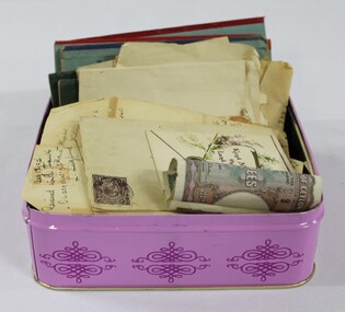
Financial record - Haeusler Collection: Tin of Letters, Foreign Money & Savings Bank Passbooks, Banque de Syrie et du Liban (Bank of Syria and Lebanon)
The Wodonga Historical Society Haeusler Collection provides invaluable insight into life in late nineteenth and early twentieth century north east Victoria. The collection comprises manuscripts, personal artefacts used by the Haeusler family on their farm in Wodonga, and a set of glass negatives which offer a unique visual snapshot of the domestic and social lives of the Haeusler family and local Wodonga community. The Haeusler family migrated from Prussia (Germany) to South Australia in the 1840s and 1850s, before purchasing 100 acres of Crown Land made available under the Victorian Lands Act 1862 (also known as ‘Duffy’s Land Act’) in 1866 in what is now Wodonga West. The Haeusler family were one of several German families to migrate from South Australia to Wodonga in the 1860s.This item has well documented provenance and a known owner. It forms part of a significant and representative historical collection which reflects the local history of Wodonga. It contributes to our understanding of the social history of early twentieth century Wodonga. Early 20th century rupee from British Ceylon (Sri Lanka), and interwar era livre from Greater Lebanon (Lebanon and Syria). The livre were issued during the French League of Nations mandate period. Collection of savings bank passbooks from the Savings Bank Wodonga. Text on letters, money and bank passbookshaeusler collection, wodonga, money, notes, bank notes, banking, currency, syria, lebanon, ceylon, sri lanka -
 Bendigo Historical Society Inc.
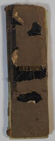
Administrative record - Arthur Allsop Collection: Day book
Arthur Allsop went into the business office at Bendigo (Vic.) of the late Mr. Alfred Joseph. He later operated as an independent bookmaker. Arthur Allsop was a partner in the firm of Kelly and Allsop and was involved in mining and speculation in Bendigo. He was elected as a member of the Bendigo Stock Exchange in 1906. He started his athletic career at picnic sports and was a fine athlete winning many foot races. For 15 years he acted as secretary of the Sandhurst City Fire Brigade, he was captain of the Bendigo lacrosse team. He was a fair cricketer, and played against the English and Australian Elevens. He played football, and acted as secretary to the Bendigo Football Club. In later years he played bowls and captained pennant teams. He was a Past District- Grandmaster in the M.U.I.O.O.F. Allsop eventually moved to Melbourne and then Sydney working as a bookmaker. He died in Sydney in 1921. His wife Belle died in Bendigo in 1914 and is buried in the Bendigo Cemetery.Day book used by Bookmaker Arthur Allsop as a ledger. The paper covering of the cover has been worn off on most of the book. Pages have ruled columns. The book contains handwritten records of races across Victoria including names of horses and betting records. Handwritten entries contain names and payment records.horse racing, bookmaker, arthur allsop, kelly and allsop -
 Vision Australia
Administrative record - Text, 67th Annual report 1962 Association for the Blind of Victoria, 1981
Articles in annual report include: a short history of the AFB, President's Report, report on Ballarat, Bendigo and Brighton Homes, financial information, the work of the Welfare Service division, opening of two flatlets for aged blind at Ballarat, resignation of Celeste Baird as choirmaster after 17 years and A Williams stepping into the role, need for a better clubhouse which has been little changed since it was built over 30 years ago, students from Ballarat Teachers college read to home residents, publication of 'Courage' magazine to keep everyone up to date on Association events, and a profile on Russian migrant Alex Momot and how the AFB assisted him settle into Australia.1 printed volume with black and white illustrationsassociation for the blind, kelaston home (ballarat), elanora home (brighton), mirridong home (bendigo), alex momot, rosalie tyers, e irvine, l adamson, mrs r clarke, matron e mcleod, a sharry, matron rosewall, mrs s mcenroe, celeste baird, e goulding, mrs a bulluss, mrs a n roach, mrs m macdowell, mrs t carson, mrs j stanley smith, pam barker, mrs l thomas, mrs a mansfield, mrs l rogerson, elsie henderson, mrs murphy, mrs w christian, h h mackenzie, sister b agar, annual reports -
Stawell Historical Society Inc
Map, Gold Mines of Australia, Gold Mines of Australia underground workings. Newington Rd Darlington Rd Area 1950, 1950
Plans Showing Surveys & Drilling Stawell InvestmentGold Mines of Australia Stawell Investment 2003 mining, gold, map -
 Nhill Aviation Heritage Centre
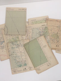
Map - Aeronautical Maps x 9, May 1943
Typical of the maps used during navigation training here at Nhill during WW2Aeronautical maps of Victoria, Printed on light card green text and markingsThird Edition May 1943, Sheet K8, Australian Aeronautical Map, Equatorial scale 1:1000,000map, aeronaughtical map, navigation -
 Eltham District Historical Society Inc
Negative - Photograph, Open Day, Eltham Living and Learning Centre, 7 Nov 1987
Open Day, Eltham Living and Learning Centre, part of the Eltham Community Festival activites, 7 Nov. 1987eltham, eltham festival, eltham living and learning centre, living and learning centre, open day -
 Eltham District Historical Society Inc
Negative - Photograph, J.A. McDonald, Reconstruction works, Research Oval, Jan. 1961
Looking southeast Late January 1961Record of various Shire of Eltham infrastructure works undertaken during the period of 1952-1962 involving bridge and road reconstruction projects, sometimes with Eltham Shire Council Project Reference numbers quoted. It was during this period that a number of significant improvements were made to roads and new bridges constructed within the shire that remain in place as of present day (2022). In many situations, the photos provide a tangible visible record of infrastructure that existed throughout the early days of the Shire. The album was put together by or under the direction of the Shire Engineer, J.A. McDonald.shire of eltham, 1961-01, infrastructure, reconstruction works, research (vic.), research oval -
 Ringwood RSL Sub-Branch
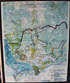
Map - Vietnam map, 1969-1972 map Vietnam on hard backing
-
Moorabbin Air Museum
Administrative record (item) - Maintenance Form Canberra A84-222
-
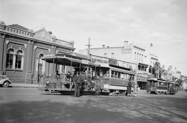 Melbourne Tram Museum
Negative, Ellis Collection, 1940
Negative (120) of a cable tram grip car and saloon car 558 outside the Nicholson St Winding house tram stop, with another cable tram departing, saloon car 528, towards the city. In the background is Osborne House and shop selling The Age, and the Herald. Hi Res image filed in the dbtext/hawthtramcoll/Large Images/htd3594large.jpg. A low resolution A4 laminated was received with the negatives. Based on a billboard date in Reg Item 3593, the year is 1940.trams, tramways, cable trams, nicholson st, winding houses, conductors, passengers, tram stops, tram 558, tram 528 -
Clunes Museum
Financial record - RECEIPTS
.1 J.S.MULCAHAY 24/7/1895 .2 J.F.WILSON OCTOBER 1894 .3 W.J. COCKING JAN 1895 .4 W/ BLACKBARD JAN 1897 .5 W. TURNBULL 1 AUG 1893 .6 G G SIMONS JULY 1 1895 .7 R. GEORGE & SON OCT. 9 1895 .8 R. GEORGE & SON JAN 9 1897 RECEIPTS ISSUED BY CLUNES BUSINESSES TO THE FAWCETT FAMILY FOR GOODS AND SERVICES INCLUDING BLACKSMITH, BOOTS AND SHOES, BAKER, GROCER, BOOKSELLER AND STATIONERS , PRODUCE, TOOLS AND IMPLEMENTS, BETWEEN 1893 AND 1897fawcett family, mulcahey, wilson, cocking, blackhard, turnbull, symons -
 Federation University Historical Collection
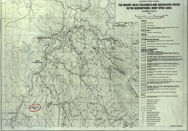
Map, The Mount Read Volcanics and Associated Rocks in the Queenstown - Whip Spur Area, 1978
Contour map of the Queenstown area in Tasmania, Australia.department of mines tasmania, volcanics, mount read, queesntown, whip spur, mining, king river, gormanston, mt owen, lynchford -
 Eltham District Historical Society Inc
Negative - Photograph, J.A. McDonald, General; Kerb Styles, Mar. 1960
Kerb crossing No returns Shire of Whittlesea March 1960Record of various Shire of Eltham infrastructure works undertaken during the period of 1952-1962 involving bridge and road reconstruction projects, sometimes with Eltham Shire Council Project Reference numbers quoted. It was during this period that a number of significant improvements were made to roads and new bridges constructed within the shire that remain in place as of present day (2022). In many situations, the photos provide a tangible visible record of infrastructure that existed throughout the early days of the Shire. The album was put together by or under the direction of the Shire Engineer, J.A. McDonald.infrastructure, 1960-03, benchmark studies, footpaths and gutters, shire of eltham, shire of whittlesea -
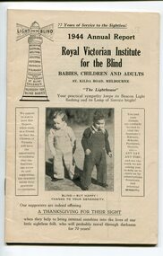 Vision Australia
Administrative record - Text, Royal Victorian Institute for the Blind annual report 1944, 1940-1944
From it's beginning in 1867, the Royal Victorian Institute for the Blind grew in size and its number of employees and benefactors. These bound volumes of annual reports contain the information sent to subscribers of the Institute and outline the notable events and difficulties facing the blind and the RVIB.1 volume bound with illustrations.royal victorian institute for the blind, annual reports -
 Eltham District Historical Society Inc
Negative - Photograph, The old Wattletree Road bridge, Eltham on east side of Diamond Creek, 1998c
Viewed from the backyard of the Bakos family residence, 107 Railway Parade Eltham (formerly 137 Railway Parade Eltham) looking north.Roll of 35mm colour negative film, 8 strips and associated 10 x 15 cm colour printKodak Gold 100-5wattletree road, bakos residence, bridge, eltham, railway parade, wattletree road bridge -
![Map - Maps, [John Batman in Melbourne], 1976](/media/collectors/4f729f5697f83e03086015b8/items/60965f673c71fad916b3a651/item-media/60965fc33c71fad916b3a805/item-fit-380x285.jpg) Greensborough Historical Society
Greensborough Historical SocietyMap - Maps, [John Batman in Melbourne], 1976
Photocopies of 4 maps showing aspects of John Batman's time in Melbourne: Map of the settlement of the Yarra 1837; Batman's map of Port Phillip and his route of exploration, 1835, drawn by Wedge; Proposed route of Batman's initial exploratiion, and Enlargement of the Geelong region of Batman's map. No citations on any copy.Photocopy of maps, 4 pages.john batman, melbourne, port phillip -
Warrnambool and District Historical Society Inc.
Administrative record - Ledger, 1878-1883
The person or business that used this ledger in Warrnambool is unknown. It contains accounts for sale of goods (one person per page) from 1878 to 1883.This ledger is of some interest because of the local 19th century Warrnambool names it contains but unfortunately the business name is unknown.This is a 19th century ledger of 888 pages. It has a hardboard cover that is tattered. It once had a red-coloured spine. The pages contain handwritten information in ink. warrnambool business ledger -
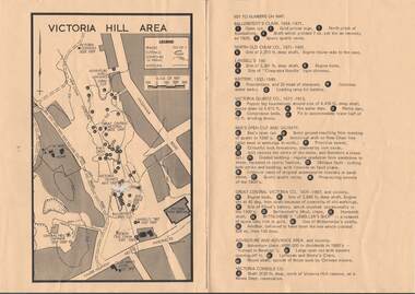 Bendigo Historical Society Inc.
Map - VICTORIA HILL AREA
Map of Victoria Hill Area printed on yellow paper. Details of tracks, cuttings, contours (in Metres) and Anticline. Location of mines, open cuts and buildings are shown. Numbers on map are: Ballerstedt's Claim 1 - 5; North Old Chum Co. 6; Lansell's 180, 7,8,11; Battery 9.10.12; Victoria Quartz Co. 13 - 17; Rae's Open Cut and Vicinity 18 - 28, Great Central Victoria Co 29 - 36, Adventure and Advance Area and vicinity 37 - 40 and Victoria Consols Co 41.map, bendigo, victoria hill, victoria hill area, victoria consols, new chum anticline, great central victoria, rae's open cut, w rae's home, victoria quartz, ballerstedt's open cut, lansell's 180, north old chum, central nell gwynne, john brown factory, gold mines hotel, cleopatra needle type chimney, floyd's battery, ballerstedt's 24yd claim, humboldt shaft, wittscheibe's jeweller's shop, luffsman and sterry's claim, victoria hill reserve, mines dept reervation -
 Eltham District Historical Society Inc
Negative - Photograph, Russell Yeoman, Burkes Bridge, Hurstbridge, c.1970
Old Burkes Bridge over Arthurs Creek.Roll of 35mm black and white negative film, 4 of 7 stripsIlford HP4bridge, bridges, arthurs creek, hurstbridge, burkes bridge -
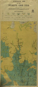 Federation University Historical Collection
Map, Geological Map of The Stieglitz Gold Field, 1940
At the bottom of the 2nd page, there is text that reads "Geologically and topographically surveyed in 1909 by W.H. Ferguson, Assistant Field Geologist. Published 1940."Rectangular geological map edged in masking tape showing Steiglitz, Victoria. Scale 48 chains to 4 inches.steiglitz, geology, geological map, north albion, moreep, mining, mine, caribald reef, durdidwarrah, gilbraltar hill, mount pleasant gully, township of steiglitz -
 Vision Australia
Administrative record - Text, Victorian asylum and school for the blind annual report 1874, 1867-1891
Annual reports were both a way of informing benefactors as well as generating new ones for charitable organisations. In 1867 an asylum and school for blind children began in Melbourne. Between that first intake and 1891, the asylum went through a great many changes, including the building of the St Kilda Road building, growing in size and developing a workshop for blind workers. 1 bound volume with illustrations.royal victorian institute for the blind, annual reports -
Stawell Historical Society Inc
Map, Easton Johnstone, Map of Stawell Surveyed by Easton Johnstone 1872, 1872
Victoria Co Crushing Machine. St Georges Co Crushing machine. Wimmera Co Crushing Machine. Government Reservoir and Drainage. Sloan Street, Skene Street Mines. old Mine WorkingsA2 map of Stawell Reefs Area. Showing Crushing Machines & Title InfoSurveyed by Easton Johnstone Contract Surveyor. Photo-Lithographed at the Department of Lands & Survey. Melbourne By J Noone 9th May 1872mining -
 Eltham District Historical Society Inc
Negative - Photograph, Eltham Shire Council, Unidentified road, Eltham district, c.1985
One of a series of images on roll of film shot by Eltham Shire Council officers focussing on road and street infrastructure maintenance and upgrades and new rollover kerb and channel profilesRoll of 35mm colour negative film, 5 stripsKodak CP100 5094infrastructure, road construction, road drainage, road sealing, roadworks, shire of eltham, streets, streetscape -
Clunes Museum
Negative - NEGATIVE PLATES
Negatives taken and owned by Carl Weickhardt, grandson of Johannes, Son of Jacob (Tank Maker)10 Glass Negative Plates in a box with a note "our grandparents D & K Patience" .1 Weickhardt Tanks .2 Fire Brigade .3 David and Kate Patience .4 Ballarat Bakery (Clunes) .5 Montage of F Weickhardt .6 Tank on a lorry .7 Tank .8 Clunes North School .9 Aeroplane landing .10 Aeroplane landingOn box; Kodak, Abbotsford, Melbournenegatives, patience, tanks, kodak -
 Bendigo Historical Society Inc.
Administrative record - Land sales applications
Green cover book with brown leather spine. The book lists the applications for allotments of land for sale. The headings in the book are: number of application, date of registry, date of application, surname, Christian name and address, parish, allotment, section, area, local land board, Licence dated, licence issued, references and remarks. The book covers the years 1908-1960.On the cover in black ink "Castlemaine" and in red ink "138 front, 130 Rear" On the first page in pen: 138-129 front 130-121 back.land sales, castlemaine -
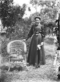 Wodonga & District Historical Society Inc
Negative - Haeusler Glass Negatives Collection - Woman Standing beside a cane chair, c1910
The Wodonga Historical Society Haeusler Collection provides invaluable insight into life in late nineteenth and early twentieth century north east Victoria. The collection comprises manuscripts, personal artefacts used by the Haeusler family on their farm in Wodonga, and a set of glass negatives which offer a unique visual snapshot of the domestic and social lives of the Haeusler family and local Wodonga community. The Haeusler family migrated from Prussia (Germany) to South Australia in the 1840s and 1850s, before purchasing 100 acres of Crown Land made available under the Victorian Lands Act 1862 (also known as ‘Duffy’s Land Act’) in 1866 in what is now Wodonga West. The Haeusler family were one of several German families to migrate from South Australia to Wodonga in the 1860s. This digital image was produced from one of the glass negatives that form part of the collection, probably taken by Louis Haeusler (b.1887) with the photographic equipment in the Wodonga Historical Society Haeusler Collection.This item is unique and has well documented provenance and a known owner. It forms part of a significant and representative historical collection which reflects the local history of Wodonga. It contributes to our understanding of domestic and family life in early twentieth century Wodonga, as well as providing interpretative capacity for themes including local history and social history.Digital image created from the Haeusler Glass negative collection. A woman standing beside a cane chair. She has one hand on the back of the chair, the other holding a flower. C. 1910wodonga pioneers, haeusler family, glass negatives, dry plate photography, wodonga families -
Bendigo Historical Society Inc.
Map - LOCAL AREA PLANS, See above
Map: Compilation of maps: Village of Redcastle dated april 14 1861, Township of Yarraberb dated 14 July 1874, Hamlet of White Hills dated December 27 1872, Road survey of Toolleenmap, parish plan, redcastle, yarraberb, white hills, toolleen