-
 Bendigo Historical Society Inc.
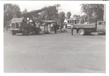
Photograph - BASIL MILLER COLLECTION: WORKSITE
Black and white photograph of road works in Carpenter Street affecting the progress of trams. Contractor W. J. Doyle. Inscriptions on reverse: Stamped in black of photo E938.person, individual, basil miller -
 Glenelg Shire Council Cultural Collection
Photograph - Photograph - Sheet of (10) Contact Prints, n.d
Port of Portland Authority Archives.port of portland archives, silo construction -
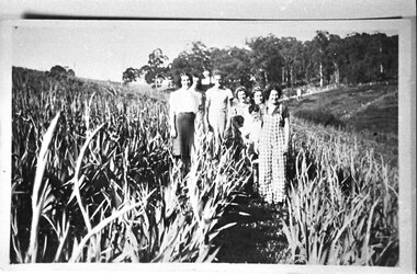 Southern Sherbrooke Historical Society Inc.
Photograph - Women in gladiolus crop, Menzies Creek
Photograph shows about six women and a young boy standing in a field of gladioli in Menzies Creek. In the background there is an open field and trees. -
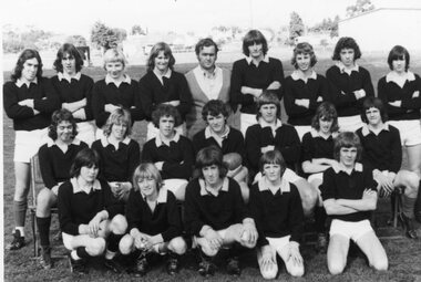 Stawell Historical Society Inc
Photograph, South Football Team - Premiers 1975
South Football Team - Premiers 1975stawell sport -
Glenelg Shire Council Cultural Collection
Photograph - Photograph - Cape Grant Quarry, 14/01/1958
Port of Portland Authority ArchivesBack: Purple PHT stamp '14 JAN 1958'port of portland archives, cape grant quarry -
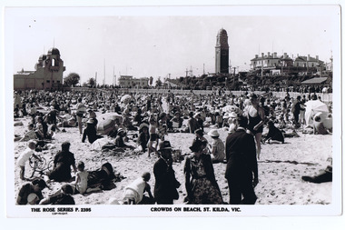 St Kilda Historical Society
Photograph, Rose Stereograph Co, St Kilda Beach, 1927
Crowds on Beach, St Kilda. The Shelter Pavilion, Catani Gardens. The Rose Series Postcardblack and white postcard, original, good condition[front, printed] The Rose Series p. 2395; Crowds on Beach, St. Kilda [back, handwritten, pencil] 1940-60 [postcard imprint] -
 Melbourne Legacy
Photograph, Girls Classes 1945, 1945
A photo of senior girls performing their exercises in a class. The girls were dressed in their physical exercise kit which was provided by Legacy to the junior legatees. The photo appears professional and may have been taken by a newspaper as part of them publicising the work of Legacy. The photo is dated 6 February 1945. Throughout the year Melbourne Legacy provided classes for Junior Legatees such as dancing, gymnastics and Eurythmics. The Demonstration was an annual event to showcase their skills. Melbourne Legacy conducted Annual Demonstrations / Parades from 1928 through to 1979, usually held at Melbourne Town Hall. The beautiful costumes were made by members of the Junior Legacy Mothers' Club and the Melbourne Legacy Wives' Association.An important photographic record of the work of Legacy in the 1940s.Black and white photo senior girls in their exercise class, part of a photo album with blue leather look back and front cover. One of 20 pages with black and white photos attached to the majority of both sides of the pages.junior legatees, girls classes, dance, exercise -
 Surrey Hills Historical Society Collection
Photograph - 63 Shepherd Street, Surrey Hills, The Street Where You Live Project
Photos documenting this address as part of a photographic series undertaken by volunteer photographers during 2013 and 2014 for The Street Where You Live Project. This was organised through the Surrey Hills Neighbourhood Centre and covered the postcode 3127 in the cities of Boroondara and Whitehorse.These photos provide a snapshot of real estate in the suburbs of Mont Albert and Surrey Hills during a period of rapid change with many properties on large blocks demolished to create higher density residential development or renewal of single dwellings. At particular risk were properties not covered by heritage overlays, especially interwar housing and post 1950's housing. -
Glenelg Shire Council Cultural Collection
Photograph - Photograph - Councilors at Casterton Town Hall, c. 1963
Sourced from Casterton Town Hall (former Shire of Glenelg)Black and white photo. Three West Riding councilors sitting behind a desk. Honour Board of Past Presidents of Shire of Glenelg, 1863 - 1963, on wall behind them. Council Chambers, Casterton Town Hall.Front: 'D' - pencil Back: 'West Riding Councilors' Blue biro line, arrowed each end, drawn across photo. '3" ' above line -
Port Melbourne Historical & Preservation Society
Plan - Possible maritime shed, Borough of Sandridge, 1870s
An identified building plan - presumably a maritime shed (front elevation faces "the river") - proving front, traverse and longitudinal sections. Possibly two buildings. Plan No. 3.Charles Clay B.S. [Borough Surveyor]:W. Weatherston[e]built environment - civic, piers and wharves, charles clay, william weatherston[e] -
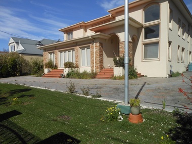 Surrey Hills Historical Society Collection
Photograph - 3 Carlyle Crescent, Mont Albert, The Street Where You Live Project
Photos documenting this address as part of a photographic series undertaken by volunteer photographers during 2013 and 2014 for The Street Where You Live Project. This was organised through the Surrey Hills Neighbourhood Centre and covered the postcode 3127 in the cities of Boroondara and Whitehorse.These photos provide a snapshot of real estate in the suburbs of Mont Albert and Surrey Hills during a period of rapid change with many properties on large blocks demolished to create higher density residential development or renewal of single dwellings. At particular risk were properties not covered by heritage overlays, especially interwar housing and post 1950's housing. -
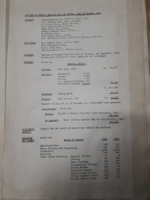
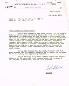 Ballarat Tramway Museum
Administrative record - Memorandum, State Electricity Commission of Victoria (SECV), "Works Division - Organisation", 9/03/1971 12:00:00 AM
Yields information about the supervision of the Ballarat SEC workshops., Yields information about the supervision of the Ballarat SEC workshops.Memorandum on Electricity Supply Department letterhead, quarto, from the Branch Manager, I Pellet to various staff with a copy to the Tram Depot Foreman, dated 9/3/1971 titled "Works Division - Organisation", about the supervision of the works division while the Superintendent Mr Trusler is working in Melbourne 3 days a week. Works Manager Mr R Wudge on other duties. Also refer to Mr. Sadler. Signed "Ivan Pellet"trams, tramways, staff, sec, ballarat, superintendents -
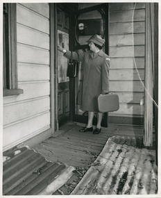 Royal District Nursing Service (now known as Bolton Clarke)
Photograph - Photograph, black and white, 15 05 1967
Sister McDonald is visiting a patient in her home to administer nursing care. The Trained nurses of the Melbourne District Nursing Society (MDNS), later known as Royal District Nursing Service (RDNS), visited patients in their home and gave best practice care in many fields of nursing, and to people of many cultures, throughout its 130 years of expansion. Initial visits not only assessed the specific nursing situation but the situation as a whole. Their patients ranged in age from babes, children, adults to the elderly and referrals were taken from Hospitals, General Practitioners and allied Health facilities. Some of the care the Sisters provided is as follows: – Post-Natal care given to mother and babe, Wound Care following various types of surgery, accidents, burns, cancer, leg ulcers etc. Supervising and teaching Diabetic Care, including teaching and supervising people with Diabetes to administer their own Insulin, and administering Insulin to those unable to give their own injections. Administering other injections and setting up weekly medication boxes. The Sisters performed Catheterizations on adults suffering from conditions such as Quadriplegia, Paraplegia, Multiple Sclerosis (MS), Motor Neurone Disease (MND) and Guillan-Barre Syndrome, and when required at school on children for e.g. those with Spina Bifida. The Sisters visited those requiring Cystic Fibrosis support and care; those requiring Haemo-Oncology care, including visiting children at school; those requiring Home Enteral Feeding care, and those requiring IV therapy at home and home Dialysis. Palliative Care was given including pain relief with the use of syringe drivers, personal care as needed, and advice and support to both patient and family. The Sisters provided Stoma management to those needing Urostomy, Ileostomy and Colostomy care and those requiring Continence care. HIV/AIDS nursing care was provided; visits to Homeless Persons were made. Personal care was given to patients ranging in age and with varying mobility problems, such as those with MS, MND, Guillan-Barre Syndrome, Poliomyelistis, Quadriplegia, Paraplegia, Acquired Brain Injury, to those following a Cerebrovascular Accident (Stroke), those with severe Arthritis and those with a form of Dementia. When necessary the elderly were assisted with personal care and advice given on safety factors with the use of hand rails, bath or shower seats, and hand showers. Rehabilitation with an aim towards independence remained at the forefront of the Sister’s minds and when possible using aids and instruction on safe techniques enabled the person to become fully independent. All care included giving advice and support to the patient and their Carers. The Sisters liaised with the persons Doctor, Hospital and allied Health personal when necessary.Black and white photograph of Royal District Nursing Sister, (RDNS), Sister B. McDonald, wearing her grey uniform coat, and her grey peaked hat over her dark short hair and is carrying her rectangular nursing case in her left hand. She is standing on the wooden veranda between the open wire door and the house; her right hand is knocking on the main door of a patient's home. Behind her, an electricity meter can be seen on the wall of the house behind the wire door. The door of the house sits near the corner of the horizontal weatherboard house, whose weatherboards can be seen to the left and right of Sister McDonald. Part of a fluted veranda post can be seen to the right of the photograph and two sheets of corrugated iron can be seen in the foreground.Photographers stamp. 'Quote No. GE 55rdns, royal district nursing service, rdns uniform, rdns patient care, sister betty mcdonald -
 Kew Historical Society Inc
Photograph - 8 roomed DF Brick Villa, Kew, J E Barnes, c.1920
Subdivision plans are historically important documents used as evidence of the growth of suburbs in Australia. They frequently provide information about when the land was sold on which a built structure was subsequently constructed as well as evidence relating to surveyors and real estate and financial agents. The numerous subdivision plans in the Kew Historical Society's collection represent working documents, ranging from the initial sketches made in planning a subdivision to printed plans on which auctioneers or agents listed the prices for which individual lots were sold. In a number of cases, the reverse of a subdivision plan in the collection includes a photograph of a house that was also for sale by the agent. These photographs provide significant heritage information relating house design and decoration, fencing and household gardens. The photograph is of additional aesthetic significance as it was photographed by J. E. Barnes. Josiah Earl Barnes is a nationally significant photographer. He was also the most important photographer to have worked in Kew. He was active as a photographer in the district from c.1906 until his death in 1921. Best known as 'the Embarkation Photographer' (see the Australian War Memorial collection), J. Earl Barnes was also the official photographer employed by the Borough (and later Town, then City) of Kew. He clearly also completed commercial jobs for local businesses, as is the case in this photograph of a house for a local real estate and financial agent.A photograph, mounted on board of a double fronted Federation-era brick villa in Kew, photographed for a local real estate agent and financier by J. E. Barnes of Kew. On the reverse of the photograph is a subdivision plan for the Normanby Estate, East Kew - 2016.0039.1. As can be seen from the image, there is a large tear on the surface of the photograph.The brown card on which the photograph is mounted includes the following handwritten description, which may aid the identification of the house: "Kew, 3 minutes from tram, 8 roomed DF Brick Villa, tile roof including two attics, sleepout, bathroom, heater, E Light, Entrance Hall, double doors, leadlights, laundry, garden, lawns, land 75 x 170, 1975 pounds". Also photographers inscription on mount, lower left: J. E. Barnes / Photo / Phone 1966 Haw. KEW.j. e. barnes, josiah earl barnes, j. earl banes - photographer, architecture - federation style, houses - kew, real estate photographs -
Malmsbury Historical Society
Photograph (Item), Malmsbury Landscape, Malmsbury ca1988
Buildings - Sign Post -
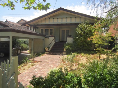
Surrey Hills Historical Society Collection
Photograph - 1 Alandale Street, Surrey Hills, On The Street Where You Live Project
Photos documenting this address as part of a photographic series undertaken by volunteer photographers during 2013 and 2014 for The Street Where You Live Project. This was organised through the Surrey Hills Neighbourhood Centre and covered the postcode 3127 in the cities of Boroondara and Whitehorse.These photos provide a snapshot of real estate in the suburbs of Mont Albert and Surrey Hills during a period of rapid change with many properties on large blocks demolished to create higher density residential development or renewal of single dwellings. At particular risk were properties not covered by heritage overlays, especially interwar housing and post 1950's housing. -
 Vision Australia
Administrative record - Text, Royal Blind Society council meeting minutes 23/9/1963 to 25/2/1968, 1963-1968
These minutes contain information on attendees, meeting chairs, apologies, correspondence, subscriptions, donations, legacies and general business. Reports are also included from Auxiliaries, Auditors, Library and Home teacher, Directors, The Black and White committee, Victor Maxwell House, Helen Keller Hostel, The Victor Maxwell Kindergarten, The Sandy Robertson Kindergarten, Alexis Albert House, Lighthouse, Silver Lighthouse committee, Newcastle Branch, 'Heathfield' and other Woollahra properties. 22/3/1965 it was noted to assist blind persons with the transfer to Decimal Currency an application had been made to the Commonwealth Treasurer for early release of specimen coins and notes. 24/1/1996 it was resolved that a dollar note gauge be supplied to all blind persons in N.S.W. 30/11/1966 it was noted the Management Committee had recommended to Council that the Society should transfer all its activities currently conducted at Williams Street to Mitchell Street and that the William Street be offered for sale at not less than $700,000. 1 volume of typed sheets glued to pagesroyal blind society of nsw, annual reports -
 Whitehorse Historical Society Inc.
Photograph, Cottage Street, Blackburn
Black and white photo of Cottage Street, Blackburn, showing mixture of buildings as Factories replace Houses.cottage street, blackburn. -
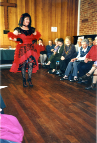 Whitehorse Historical Society Inc.
Photograph, Fashion from the Past - Parade, 1/08/2002 12:00:00 AM
Coloured Photograph of the fashions from the past fund raiser parade for the Society. Funded by the Whitehorse Arts Council. Held in the Forster Hall of Christ Church Mitcham, Whitehorse Road, Mitcham.fashions from the past, christ church anglican church mitcham, whitehorse arts council, nunawading & district historical society inc. -
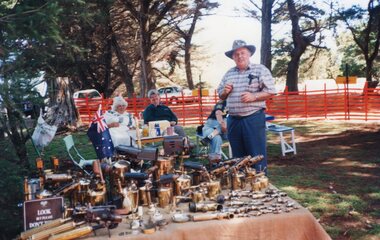 Churchill Island Heritage Farm
Photograph - Photograph of brass/copper items on market stalls
Churchill Island Heritage Farm has a large collection of photographs dating from the nineteenth century. This series shows photographs taken from around the Heritage Precinct.Photograph showing a covered trestle table covered with various brass/copper items with a group of people sitting and standing behind it.catalogue number written on reverse in pencilchurchill island, photograph -
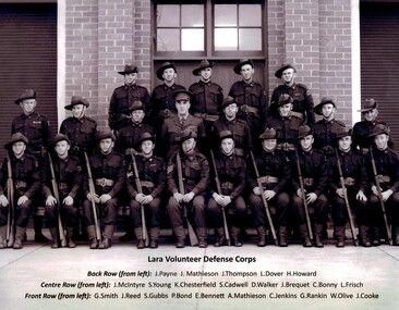 Lara RSL Sub Branch
Photograph, Lara Volunteer Defense Corps
J. McIntyre (centre row left) Foundation member of Lara RSL.Black and White Photo of a Group of soldiersLara Volunteer Defense Corps With names listed underneath -
Moorabbin Air Museum
Manual (Item) - RAAF Variable Displacement Hydraulic Pump Manual, Royal Australian Air Force Variable Displacement Hydraulic Pump Model AS-66698-L8A
RAAF -
 Surrey Hills Historical Society Collection
Photograph - 43 Park Road, Surrey Hills, On The Street Where You Live Project
Photos documenting this address as part of a photographic series undertaken by volunteer photographers during 2013 and 2014 for The Street Where You Live Project. This was organised through the Surrey Hills Neighbourhood Centre and covered the postcode 3127 in the cities of Boroondara and Whitehorse.These photos provide a snapshot of real estate in the suburbs of Mont Albert and Surrey Hills during a period of rapid change with many properties on large blocks demolished to create higher density residential development or renewal of single dwellings. At particular risk were properties not covered by heritage overlays, especially interwar housing and post 1950's housing. -
 Ringwood and District Historical Society
Photograph, Ringwood State School - Grade 3A, 1960
Black and white photograph - Grade 3A,1960"Attached to photograph" Back Row- L to R: No names 2nd Row- L to R: No names 3rd Row- L to R: No names Front Row- L to R: No names Teacher: -
 Wodonga & District Historical Society Inc
Photograph - Codling Collection 01 - Melba Theatre Wodonga and its Demolition, c1970s
Miss Olive Codling was a Foundation Member and a Life Member of the Wodonga Historical Society. Many of her prize-winning photos are held in the Society Collection. She also held a range of roles and committee positions in a wide range of Wodonga community organisations. MELBA THEATRE, WODONGA operated in the Shire Hall building on the corner of High Street and Melbourne Road (Elgin Street), Wodonga. The Shire Hall was built in 1890. The date on the facade of the building represents the date of the formation of the Shire in 1876. In December 1929, Enterprise Pictures were screening films in the open air theatre adjacent to the Shire Hall or sometimes in the hall itself. In 1943 “Melba Theatre, Shire Hall” was advertised with that name for the first time. In 1948 Mr K Bounader, a picture proprietor from Holbrook with 39 years in pictures behind him assumed control of the Melba Theatre, Wodonga. The Bounader family continued to run the theatre well into the 1960s. The hall was also used for functions such as school socials and concerts. Competition from drive-in theatres and television had an impact on theatre audiences. Finally, the Melba Theatre screened its last film in 1968. A school speech night in 1969 is the last known event in the Melba Theatre. It was demolished along with the Shire Hall in 1971 and replaced with a supermarket and car park.These images are significant as they document an historic buildings in Wodonga which played an important part in the social life of the community.2 black and white photos of the Melba Theatre in Wodonga and its demolition Over doorway: "MELBA THEATRE"high st wodonga, melba theatre, wodonga buildings -
Moorabbin Air Museum
Manual (Item) - Fitters Course Notes - Instrument Fitter, Navigational Equipment - RAAF School Technical Training
-
University of Melbourne, Burnley Campus Archives
Photograph - Black and white print, 1948
"C.R.T.S. Certificate Course Graduation Ceremony. Aug 1948." THKcrts, certificate course, graduation ceremony, e. m. gibson collection -
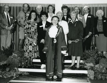 Ringwood and District Historical Society
Photograph, Ringwood City Council - Community Service Awards, 1991. Presented by Cr Betty Milton, Mayor City of Ringwood
Black and white photograph"Wriitten on back of photograph" Community Service Awards 1991. Mayor Betty Milton. Group photograph. Back Row L to R - Anthony Worley, Keith Fry, Irene Fuhrer, Ruth Hawkins, Mandy Carolan, John Mierisch, John McCallum - Howell, Mary McPherson. Front Row L to R - Irene Harris, Olive Stewart, Mavis Thompson, Nancy Low. Front - Mayor Betty Milton. -
 Eltham District Historical Society Inc
Photograph - Aerial Photograph, Landata, Eltham; Crown Allotment 15, Section 5, Parish of Nillumbik (Stokes Orchard Estate), Mar. 1987
Centred on present day Diosma Rd, Stokes Pl, Nyora Rd and Eucalyptus Rd Historic Aerial Imagery Source: Landata.vic.gov.au Aerial Photo Details: Project No :1716 Project : WESTERN PORT FORESHORES Run : 15 Frame : 108 Date : 03/1987 Film Type : B/W Camera : RC10 Flying Height : 5600 Scale : 10000 Film Number : 4102 GDA2020 : 37°43'00"S, 145°10'13"E MGA2020 : 338725, 5824036 (55) Melways : 22 D5 (ed. 42)719 (55) Melways : 22 D4 (ed. 42) A History of the Development of Crown Allotment 15, Section 5, Parish of Nillumbik – Stokes Orchard Crown Allotment 15, Section 5, Parish of Nillumbik (CA15) is a square allotment of 158 acres or approximately a quarter of a square mile. It lies just beyond the eastern end of Pitt Street, south of Nyora Road to the northern end of Eucalyptus Road and extends east from Eucalyptus Road to Reynolds Road. The topography of CA15 is generally steep, sloping up to a hill near the centre of the land, the ridgeline passing through the properties along the southern side of Diosma Road. Eucalyptus Road is a straight north-south road with its northern end at the north west corner of CA15. Until the end of the 1970s this road was an un-named Government Road and was largely not open to traffic. With residential development in the 1970s the road was constructed, and the council allocated the name obviously in recognition of the predominant species of the local bushland. CA15 was purchased from the Crown by George D’Arley Boursiquot, a prominent Melbourne printer, on 28th October 1852. On November 23, 1922, former Member for Gippsland and Melbourne Real Estate Agent, Hubert Patrick Keogh purchased the allotment then sold it March 13, 1925, to local farmer, Robert David Taylor, a former Shire of Eltham Councillor (1911-1920) and Shire President (1919). Taylor had extensive land holdings stretching west towards Bible Street and Main Road. The Taylor home was situated at the top of the hill in Bible Street at present day 82 Bible Street. At the time of Taylor’s purchase in 1925, CA15 was subdivided into 48 lots that could be described as small rural properties or large residential lots. A typical lot size was one hectare or 2.5 acres. The subdivision created two roads, Nyora Road, and Diosma Road, each following an irregular alignment between Eucalyptus and Reynolds Roads. However, the lots were not sold off separately nor were the roads constructed. The land effectively remained as one parcel for many further years. Robert David Taylor died November 30, 1934, and probate was granted to his son of the same name, Robert David Taylor of Bible Street, Salesman and William McLelland Vance Taylor of 73 Emmeline Street, Northcote, Clerk, with the transfer of the land into their names on July 8, 1935. Frank Stokes worked as a qualified accountant at Kennons leather factory in Burnley, while living at 1 Thomas Street, Mitcham. He suffered from migraines and wanted to return to working the land (he had previously worked on farms and orchards since coming to Australia from England in 1926, both in WA and Vic.). He first travelled to the district by train in July 1942 to find land with the intention to establish an orchard. By chance he met Arthur Bird of Bird Orchard (bounded by Pitt Street, Eucalyptus Road, and Wattle Grove) and they got talking over their common interest. Arthur put Frank up for the night and pointed out the land, 158 acres- part of the Taylor Estate- £900, Crown Allotment 15, Section 5, Parish of Nillumbik (CA15) somewhat diagonally opposite Bird Orchard. Stokes applied through the Riverina Agency to purchase the land who in turn applied for permission from Canberra to sell as there was a new government regulation introduced during the Second World War banning land sales except for immediate production. Stokes obtained a loan on his Mitcham house of £600 @ 5% and paid £450 deposit with quarterly payments of £15 spread over 5 years. Stokes was assisted and advised by Arthur Bird who farmed the neighbouring orchard. In early 1943 Stokes took possession and would catch the train out to Eltham on Fridays after work and began building a hut on the corner of Nyora Road and the Government Road (Eucalyptus Road) for shelter and to lock up tools. He established an orchard on the central western part of the land through the centre of which ran a natural waterway (part of the present-day linear park) and was able to pay a neighbour (Hawkins) to help with clearing and fencing 25 acres, and with a horse and single furrowed plough, planted approximately 2,500 fruit trees - cherries, peaches, plums, almonds, pears, apricots and lemons as well as a few apples and oranges; a massive task. Aerial photographs from the 1940s through to the 1990s clearly show the orchard with most of the larger CA15 site remaining as natural bushland. A huge problem was hares and rabbits eating all the new buds off the tiny trees. As well as laying poison he painted the trees with a mixture of cow manure and lime, often working by moonlight. Procurement of wire and wire netting was difficult because of the war but after much effort he obtained a permit from the Agricultural Department for supplies in March 1944. In February 1945 Stokes applied for a permit to build a “packing shed” as no house building was allowed. It was to be 33 feet x 21 feet and cost £312. It was constructed mostly from second-hand materials, which were hard to obtain, especially iron for roofing. Stokes finished work at Kennons on October 31, 1945, and in March 1946 he sold the family home at Mitcham for £1,230 plus £170 for furniture. On May 15, 1946, title to the CA15 property was issued to Frank Howard Alfred Stokes, Orchardist and Gladys Ethel Stokes, Married Woman, both of Pitt Street, Eltham. The family of five then moved into the very unfinished “packing shed” at Eltham, which was a struggle to weatherproof. Eventually rooms were divided off and lined with hessian bags and whitewashed. Their income was firewood (cut and sold), selling rockery stones and cut Sweet Bursaria. (It was discovered during the 1940s that Sweet Bursaria contained the sunscreen compound Aesculin. The RAAF utilised this compound from Sweet Bursaria during WW2 for pilots and gunners.) The orchard’s first fruit sale was a half-case of Le Vanq peaches in December 1947 for the price of 8 shillings. In 1956 plans for house were drawn and Glen Iris bricks purchased (1956 Olympic Rings variant). The building of the house commenced in 1957 - 12 feet of original packing shed was removed – and was completed in 1959. Water was connected from newly built pressure storage on the property at the end of 1959 and the electricity connection for the first time at 3pm on April 29, 1960. The house remains to present day (somewhat modified) at 1 Nyora Road, home to Nyora Studio Gallery. On occasions, spare remnants of the 1956 bricks have been known to be unearthed in gardens on the estate as they were utilised by Frank Stokes to fill in rabbit holes. On May 26, 1950, a parcel of land was compulsorily acquired by the Melbourne and Metropolitan Board of Works on the hilltop to establish an easement for a high-level service reservoir to augment Eltham’s water supply. The project also included pipe tracks for the necessary water mains. The reservoir has now been superseded by higher level water tanks east of Reynolds Road and its former site is now a public reserve. On November 27, 1964, the State Electricity Commission served notice to compulsorily acquire a further parcel through the eastern part of the land for a major electricity transmission line that augmented supply from the La Trobe Valley to Melbourne. The easement was registered February 11, 1966. The easement was widened July 18, 1969 for a second transmission line to be constructed. In 1971 Melbourne Metropolitan Planning Scheme amendments adopted Nyora Road as the boundary between a residential zone to the north and a rural zone to the south. This determined the future development of the land. In the mid-1970s the Shire of Eltham divided the orchard into numerous rate-able parcel lots, the 48 lots having been established in 1925 and the subsequent rates assessment proved unsustainable for Stokes. He commenced selling lots outside the boundary of the orchard, north of Diosma and South of Nyora. However shortly later the land between Nyora and Diosma Roads and west of the electricity easement was sold and subdivided into residential lots, a housing development by Macquarie Builders and marketed as the Stokes Orchard Estate. New streets were created, and most were named after trees, although one, Stokes Place, commemorates the former owners. The development was undertaken in two stages; Stage 1 (1975) encompassing Scarlet Ash Court, Ironbark Close and Peppermint Grove bounded by Nyora and Eucalyptus roads and Stage 2 (1978) encompassing Stokes Place, Orchard Way, The Crest and The Lookout bound by Nyora and Diosma roads. The developer, Macquarie Builders went bankrupt shortly after the release of Stage 2 leaving many purchasers to fend for themselves and arrange for their own independent builders. There were also difficulties with sewerage for the land immediately south of Diosma Road and so the conventional residential lots were abandoned in favour of larger lots. The development of Orchard Way, The Crest and The Lookout did not proceed as planned and the proposed lots were incorporated into five-acre parcels instead. These included a low-density group housing development by the Graves family and the award winning Choong House (1983) with Gordon Ford developed garden immediately next door situated on the ridge of the hill nestled amongst the original bush, Eucalypt trees and Sweet Bursaria. In 1994, Nillumbik Shire Council applied Significant Environment and Significant Landscape overlays upon the properties on the south side of Diosma Road to ensure protection of this natural bush garden environment. With the arrival of the sewer along Diosma Road in the 1990s, most of these five-acre parcels have since been subdivided multiple times. The Choong house presently sits on a 2.7-acre property, which in 2022 Nillumbik Council nominated for Cultural Significance Heritage protection and is considered potentially significant at State level. The Stokes family were also associated with the Eltham Christian Church. In the 1970s this church had met in temporary premises in Eltham. Lots of the original 1925 subdivision remained south of Nyora Road and a number of these lots were utilized for the Eltham Christian School, which was established by the Eltham Christian Church in 1981. The school operated on this site until 2000. The premises are now used by The Vine Baptist Church. By the mid-1980s the whole of CA15 had been developed for residential and school purposes, except for the sections north of Diosma Road and between the transmission lines and Reynolds Road. Sewerage issues had been resolved for the section north of Diosma Road and in 1987 it was in the process of being subdivided into residential lots. The development coincided with the discovery of colonies of the rare and endangered Eltham Copper Butterfly on the site. This resulted in a community and political campaign to save the butterfly habitat. With the co-operation of the land developer the subdivision was altered to create two bushland reserves in the critical butterfly habitat areas. In the late 1980s the State Government was investigating options for establishing a metropolitan ring road link between Diamond Creek and Ringwood. The chosen route was adjacent to Reynolds Road and so this created a freeze on development of CA15 between Reynolds Road and the electricity easement. The ring road proposal was eventually abandoned, and this part of the land was subdivided into low density residential lots. Diosma Road has been discontinued at the electricity easement and the eastern part incorporated into View Mount Court with access from Reynolds Road. The whole of CA15 has now been developed for residential or associated purposes, ranging from conventional density to quite low density south of Nyora Road. Some remnants of the orchard remain, a few cherry trees on the Graves property and a lone apple tree in Stokes Place. The butterfly reserves comprise significant areas of remnant bushland. Linear reserves through the estate link with central Eltham via the Woodridge linear reserve and with Research along the electricity easement. CA15 as it exists today has a complicated history of rural use, Government acquisition, urban development, and community action. References: • “Stokes Orchard, an incomplete history”; Russell Yeoman with Doug Orford • Correspondence, Beryl Bradbury (nee Stokes) • Aerial Photographs, 1931-1991, Landata (landata.vic.gov.au) • Certificate of Title, Vol. 4930 Fol. 985900 • Plan Number LP 10859 aerial photo, diosma road, eltham copper butterfly, eucalyptus road, ironbark close, nyora road, peppermint grove, peter & elizabeth pidgeon collection, power transmission lines, reynolds road, scarlet ash court, stokes orchard estate, stokes place, woodridge estate, frank stokes -
 St Kilda Historical Society
Photograph, Carlisle St, c. 1862
Carlisle St looking west from Balaclava Railway Bridge, St Kilda, c1862black and white photograph, copy, poor image quality, unmountedCarlisle St. looking west from Balaclava railway bridge about 1862