-
 Eltham District Historical Society Inc
Photograph - Aerial Photograph, Landata, Eltham; Crown Allotment 15, Section 5, Parish of Nillumbik (Stokes Orchard Estate), Feb. 1979
Centred on present day Diosma Rd, Stokes Pl, Nyora Rd and Eucalyptus Rd Historic Aerial Imagery Source: Landata.vic.gov.au Aerial Photo Details: Project No :1716 Project : WESTERN PORT FORESHORES Run : 15 Frame : 91 Date : 02/1979 Film Type : B/W Camera : RC8 Flying Height : 5500 Scale : 10000 Film Number : 3286 GDA2020 : 37°42'47"S, 145°09'57"E MGA2020 : 338339, 5824447 (55) Melways : 22 C4 (ed. 42) A History of the Development of Crown Allotment 15, Section 5, Parish of Nillumbik – Stokes Orchard Crown Allotment 15, Section 5, Parish of Nillumbik (CA15) is a square allotment of 158 acres or approximately a quarter of a square mile. It lies just beyond the eastern end of Pitt Street, south of Nyora Road to the northern end of Eucalyptus Road and extends east from Eucalyptus Road to Reynolds Road. The topography of CA15 is generally steep, sloping up to a hill near the centre of the land, the ridgeline passing through the properties along the southern side of Diosma Road. Eucalyptus Road is a straight north-south road with its northern end at the north west corner of CA15. Until the end of the 1970s this road was an un-named Government Road and was largely not open to traffic. With residential development in the 1970s the road was constructed, and the council allocated the name obviously in recognition of the predominant species of the local bushland. CA15 was purchased from the Crown by George D’Arley Boursiquot, a prominent Melbourne printer, on 28th October 1852. On November 23, 1922, former Member for Gippsland and Melbourne Real Estate Agent, Hubert Patrick Keogh purchased the allotment then sold it March 13, 1925, to local farmer, Robert David Taylor, a former Shire of Eltham Councillor (1911-1920) and Shire President (1919). Taylor had extensive land holdings stretching west towards Bible Street and Main Road. The Taylor home was situated at the top of the hill in Bible Street at present day 82 Bible Street. At the time of Taylor’s purchase in 1925, CA15 was subdivided into 48 lots that could be described as small rural properties or large residential lots. A typical lot size was one hectare or 2.5 acres. The subdivision created two roads, Nyora Road, and Diosma Road, each following an irregular alignment between Eucalyptus and Reynolds Roads. However, the lots were not sold off separately nor were the roads constructed. The land effectively remained as one parcel for many further years. Robert David Taylor died November 30, 1934, and probate was granted to his son of the same name, Robert David Taylor of Bible Street, Salesman and William McLelland Vance Taylor of 73 Emmeline Street, Northcote, Clerk, with the transfer of the land into their names on July 8, 1935. Frank Stokes worked as a qualified accountant at Kennons leather factory in Burnley, while living at 1 Thomas Street, Mitcham. He suffered from migraines and wanted to return to working the land (he had previously worked on farms and orchards since coming to Australia from England in 1926, both in WA and Vic.). He first travelled to the district by train in July 1942 to find land with the intention to establish an orchard. By chance he met Arthur Bird of Bird Orchard (bounded by Pitt Street, Eucalyptus Road, and Wattle Grove) and they got talking over their common interest. Arthur put Frank up for the night and pointed out the land, 158 acres- part of the Taylor Estate- £900, Crown Allotment 15, Section 5, Parish of Nillumbik (CA15) somewhat diagonally opposite Bird Orchard. Stokes applied through the Riverina Agency to purchase the land who in turn applied for permission from Canberra to sell as there was a new government regulation introduced during the Second World War banning land sales except for immediate production. Stokes obtained a loan on his Mitcham house of £600 @ 5% and paid £450 deposit with quarterly payments of £15 spread over 5 years. Stokes was assisted and advised by Arthur Bird who farmed the neighbouring orchard. In early 1943 Stokes took possession and would catch the train out to Eltham on Fridays after work and began building a hut on the corner of Nyora Road and the Government Road (Eucalyptus Road) for shelter and to lock up tools. He established an orchard on the central western part of the land through the centre of which ran a natural waterway (part of the present-day linear park) and was able to pay a neighbour (Hawkins) to help with clearing and fencing 25 acres, and with a horse and single furrowed plough, planted approximately 2,500 fruit trees - cherries, peaches, plums, almonds, pears, apricots and lemons as well as a few apples and oranges; a massive task. Aerial photographs from the 1940s through to the 1990s clearly show the orchard with most of the larger CA15 site remaining as natural bushland. A huge problem was hares and rabbits eating all the new buds off the tiny trees. As well as laying poison he painted the trees with a mixture of cow manure and lime, often working by moonlight. Procurement of wire and wire netting was difficult because of the war but after much effort he obtained a permit from the Agricultural Department for supplies in March 1944. In February 1945 Stokes applied for a permit to build a “packing shed” as no house building was allowed. It was to be 33 feet x 21 feet and cost £312. It was constructed mostly from second-hand materials, which were hard to obtain, especially iron for roofing. Stokes finished work at Kennons on October 31, 1945, and in March 1946 he sold the family home at Mitcham for £1,230 plus £170 for furniture. On May 15, 1946, title to the CA15 property was issued to Frank Howard Alfred Stokes, Orchardist and Gladys Ethel Stokes, Married Woman, both of Pitt Street, Eltham. The family of five then moved into the very unfinished “packing shed” at Eltham, which was a struggle to weatherproof. Eventually rooms were divided off and lined with hessian bags and whitewashed. Their income was firewood (cut and sold), selling rockery stones and cut Sweet Bursaria. (It was discovered during the 1940s that Sweet Bursaria contained the sunscreen compound Aesculin. The RAAF utilised this compound from Sweet Bursaria during WW2 for pilots and gunners.) The orchard’s first fruit sale was a half-case of Le Vanq peaches in December 1947 for the price of 8 shillings. In 1956 plans for house were drawn and Glen Iris bricks purchased (1956 Olympic Rings variant). The building of the house commenced in 1957 - 12 feet of original packing shed was removed – and was completed in 1959. Water was connected from newly built pressure storage on the property at the end of 1959 and the electricity connection for the first time at 3pm on April 29, 1960. The house remains to present day (somewhat modified) at 1 Nyora Road, home to Nyora Studio Gallery. On occasions, spare remnants of the 1956 bricks have been known to be unearthed in gardens on the estate as they were utilised by Frank Stokes to fill in rabbit holes. On May 26, 1950, a parcel of land was compulsorily acquired by the Melbourne and Metropolitan Board of Works on the hilltop to establish an easement for a high-level service reservoir to augment Eltham’s water supply. The project also included pipe tracks for the necessary water mains. The reservoir has now been superseded by higher level water tanks east of Reynolds Road and its former site is now a public reserve. On November 27, 1964, the State Electricity Commission served notice to compulsorily acquire a further parcel through the eastern part of the land for a major electricity transmission line that augmented supply from the La Trobe Valley to Melbourne. The easement was registered February 11, 1966. The easement was widened July 18, 1969 for a second transmission line to be constructed. In 1971 Melbourne Metropolitan Planning Scheme amendments adopted Nyora Road as the boundary between a residential zone to the north and a rural zone to the south. This determined the future development of the land. In the mid-1970s the Shire of Eltham divided the orchard into numerous rate-able parcel lots, the 48 lots having been established in 1925 and the subsequent rates assessment proved unsustainable for Stokes. He commenced selling lots outside the boundary of the orchard, north of Diosma and South of Nyora. However shortly later the land between Nyora and Diosma Roads and west of the electricity easement was sold and subdivided into residential lots, a housing development by Macquarie Builders and marketed as the Stokes Orchard Estate. New streets were created, and most were named after trees, although one, Stokes Place, commemorates the former owners. The development was undertaken in two stages; Stage 1 (1975) encompassing Scarlet Ash Court, Ironbark Close and Peppermint Grove bounded by Nyora and Eucalyptus roads and Stage 2 (1978) encompassing Stokes Place, Orchard Way, The Crest and The Lookout bound by Nyora and Diosma roads. The developer, Macquarie Builders went bankrupt shortly after the release of Stage 2 leaving many purchasers to fend for themselves and arrange for their own independent builders. There were also difficulties with sewerage for the land immediately south of Diosma Road and so the conventional residential lots were abandoned in favour of larger lots. The development of Orchard Way, The Crest and The Lookout did not proceed as planned and the proposed lots were incorporated into five-acre parcels instead. These included a low-density group housing development by the Graves family and the award winning Choong House (1983) with Gordon Ford developed garden immediately next door situated on the ridge of the hill nestled amongst the original bush, Eucalypt trees and Sweet Bursaria. In 1994, Nillumbik Shire Council applied Significant Environment and Significant Landscape overlays upon the properties on the south side of Diosma Road to ensure protection of this natural bush garden environment. With the arrival of the sewer along Diosma Road in the 1990s, most of these five-acre parcels have since been subdivided multiple times. The Choong house presently sits on a 2.7-acre property, which in 2022 Nillumbik Council nominated for Cultural Significance Heritage protection and is considered potentially significant at State level. The Stokes family were also associated with the Eltham Christian Church. In the 1970s this church had met in temporary premises in Eltham. Lots of the original 1925 subdivision remained south of Nyora Road and a number of these lots were utilized for the Eltham Christian School, which was established by the Eltham Christian Church in 1981. The school operated on this site until 2000. The premises are now used by The Vine Baptist Church. By the mid-1980s the whole of CA15 had been developed for residential and school purposes, except for the sections north of Diosma Road and between the transmission lines and Reynolds Road. Sewerage issues had been resolved for the section north of Diosma Road and in 1987 it was in the process of being subdivided into residential lots. The development coincided with the discovery of colonies of the rare and endangered Eltham Copper Butterfly on the site. This resulted in a community and political campaign to save the butterfly habitat. With the co-operation of the land developer the subdivision was altered to create two bushland reserves in the critical butterfly habitat areas. In the late 1980s the State Government was investigating options for establishing a metropolitan ring road link between Diamond Creek and Ringwood. The chosen route was adjacent to Reynolds Road and so this created a freeze on development of CA15 between Reynolds Road and the electricity easement. The ring road proposal was eventually abandoned, and this part of the land was subdivided into low density residential lots. Diosma Road has been discontinued at the electricity easement and the eastern part incorporated into View Mount Court with access from Reynolds Road. The whole of CA15 has now been developed for residential or associated purposes, ranging from conventional density to quite low density south of Nyora Road. Some remnants of the orchard remain, a few cherry trees on the Graves property and a lone apple tree in Stokes Place. The butterfly reserves comprise significant areas of remnant bushland. Linear reserves through the estate link with central Eltham via the Woodridge linear reserve and with Research along the electricity easement. CA15 as it exists today has a complicated history of rural use, Government acquisition, urban development, and community action. References: • “Stokes Orchard, an incomplete history”; Russell Yeoman with Doug Orford • Correspondence, Beryl Bradbury (nee Stokes) • Aerial Photographs, 1931-1991, Landata (landata.vic.gov.au) • Certificate of Title, Vol. 4930 Fol. 985900 • Plan Number LP 10859 aerial photo, diosma road, eltham copper butterfly, eucalyptus road, ironbark close, nyora road, peppermint grove, peter & elizabeth pidgeon collection, power transmission lines, reynolds road, scarlet ash court, stokes orchard estate, stokes place, woodridge estate, frank stokes -
 Whitehorse Historical Society Inc.
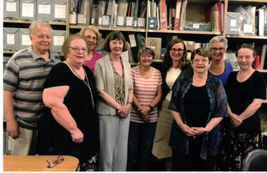
Photograph - One coloured photograph, WHS Planning Day 6/3/2019
One coloured photograph showing Members and councillers.whs planning day 6/3/2019, members -
 Bendigo Historical Society Inc.
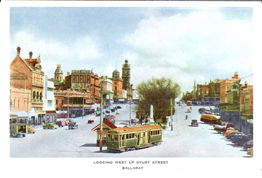
Photograph - BASIL MILLER COLLECTION: TRAM ON STURT ST - BALLARAT
Hand tinted image looking west up Sturt St, Ballarat. Nu-Colour-Nu Productions, Victoria, No. 8.person, individual, basil miller -
 Bendigo Historical Society Inc.
Document - NEW CHUM CONSOLIDATED MINE - EXPLOSION AT THE NEW CHUM COLSOLIDATED MINE
Handwritten copy of a newspaper report on an explosion at the New Chum Consolidated Mine. The explosion occurred about 7.30 am on Friday 21/1/1881 when a fire broke out in the engine house. Some dynamite and caps had been placed in the engine house for convenience sake. Seven men were injured. They were T. Sheppard, Mine Manager, Charles Porter, Enginedriver, Geo Dobridge, Lander, Peter Summers, miner, Richard Hosking, miner, Jacob Grigg. Written on the back of page 2 is 'A Tourist Guide' which gives an outline on Bendigo's gold history.document, gold, new chum colsolidated mine, new chum consolidated mine, explosion at the new chum consolidated mine, bendigo advertiser 22/1/1881, t sheppard, charles porter, geo dobridge, lander, peter summers, richard hosking, jacob grigg, r mitchell, richard hoskins, james whitford, john lethlean, w glasson, south old chum, old menzies shaft, menzies shaft -
Lakes Entrance Regional Historical Society (operating as Lakes Entrance History Centre & Museum)
Photograph, Lakes Post Newspaper, 1999c
Colour photograph of action during Under Twelve Basketball Final showing Teagan O'Reilly Chloe Kenny Tansy Owen Fitzgerald A Sproule Recreation Hall Lakes Entrance Victoriasports -
Malmsbury Historical Society
Photograph (Item), B/W Norm Monti At Heritage Week 1992, Malmsbury 1/4/1992
People - "Monti, Norm; Manktelow, Dennis" Buildings - Town Hall Associated with - "Mhs, Heritage Week" -
 Whitehorse Historical Society Inc.
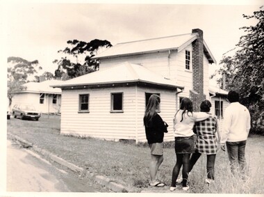
Photograph - Black and white photo, Winlaton Youth Training Centre
A house on the site was originally owned by successful businessman , Joseph Tweedle before being sold to the government. For many years it was the Winlaton Training Centre for girls. When the institution was closed the buildings were demolished and the land subdivided for housing.Four girls standing in the grounds of Winlaton outside a building.winlaton youth training centre, nunawading -
 Melbourne Tram Museum
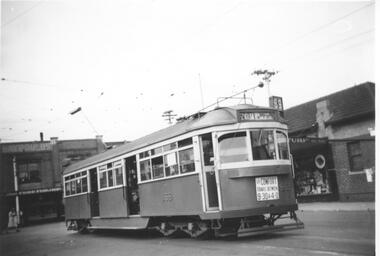
Photograph - Black & White Photograph/s, Lee A Ratten, mid 1940's
Black and white photograph of tramcar 869 in Glenferrie Road with Dash Canopy lighting. 1941 eleven SW6 class trams built by MMTB at Preston Workshops, numbers 866 to 876. Entered service 19 June 1941. Based at Malvern Depot c1948 to c1991. Advertisements in shop for Turf and Ardath. Sign on front of tram: "For comfort travel between 9:30 & 4:00" Tram has the destination of St Kilda Beach via Balaclava. Route number 69. Extensively damaged by fire in Church St at North Richmond terminus Tuesday, 14th November 2006. August 2014 transferred from Preston Workshops to Newport Workshops.trams, tramways, sw6 class, glenferrie rd, dash canopy lights, tram 869 -
Malmsbury Historical Society
Photograph (Item), "Malmsbury Gardens, Leaking Sewage", Malmsbury ca1990
-
 Ringwood and District Historical Society
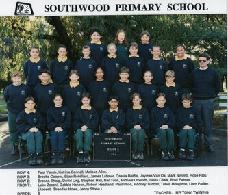
Photograph, Southwood Primary School, 1996, Grade 6 class photo
colour class photonames of class members list underneath photo -
 Bendigo Historical Society Inc.
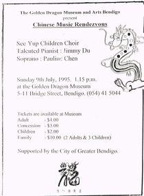
Document - MERLE HALL COLLECTION: VARIOUS DOCUMENTS RELATING TO VISIT OF SEE YUP CHILDREN'S CHOIR
Various documents relating to visit of See Yup Children's Choir , July 1995 presenting ''Chinese Music Rendezvous'' a. Two A4 flyers re the performance; b. PR info re performance; c. various correspondence; d. Correspondence from the See Yup Chinese School (to Ms Hall and ms Jack); e. Correspondence between AB and CoGB re support for the visit; f. financial documents. -
 Federation University Historical Collection
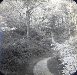
Photograph - Glass Plate, Henry Sutton, Path Through a Landscape by Henry Sutton, c1891
Henry Sutton was born in Ballarat into the musical Sutton Family. He is known as an important Australian inventor. Photograph of two boys paddling in a canal, watched by a number of onlookers.henry sutton, glass plates, photography, landscape, path -
 Bendigo Historical Society Inc.
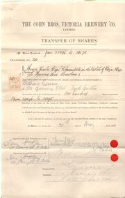
Document - COHN BROTHERS COLLECTION: TRANSFER OF SCRIPT
[a] Manilla envelope handwritten labelled 'Transfers and Script [cancelled] attached there to . The Secretary, Cohn Bros Victoria Brewery Bendigo. [b] Share Transfers and Shares dating from 1887-1915 enclosed within envelope.bendigo, industry, cohn bros brewery -
 Stawell Historical Society Inc
Photograph, Miss Betty Flavell Mr Rob Flavell
Flavell Family - Betty and Rob Flavell brother and sisterstawell -
 Bendigo Historical Society Inc.
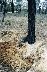
Photograph - DWYER COLLECTION: STONE WELL, MAIDEN GULLY
Photograph: image of stone well, Biffins Track, Maiden Gully. Circular structure lined with sandstone type stones. Measures 3.7 mt. across at widest point and is approx. 2.7 mt. deep. Large Ironbark on RH side of well. File contains letter from Mrs. Michele Dwyer, 27 Katherine Cres., Maiden Gully, dated 19th. Feb. 2003. Inspection by Kay MacGregor and Phil Wilkin in 2012 revealed well still intact, and on private property, not Crown Land. No heritage listing for well.bendigo, buildings, stone well, maiden gully, stone well, stonework, stone cutter. -
Federation University Historical Collection
Document, Consultation Paper: Transitional Structures for Federation Univesity Australia in 2014
This a document relating to our current status of Federation UniversityA4 typed document on white paper titled Consultation Paper: Transitional Structures for Federation Univesity Australia in 2014consultation paper, federation university australia, david battersby, transitional structures -
 Bendigo Historical Society Inc.
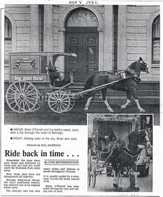
Document - LONG GULLY HISTORY GROUP COLLECTION: RIDE BACK IN TIME
Photocopy of a newspaper article titled Ride back in time. Two photos by Bill Hawking and the article by Toni Hetherington. The large photo shows the bread cart pulled by Jock, the horse and driven by Brian O'Farrell taking a trip through the city. The smaller photo shows a front view of the horse and bread cart being driven along the street. The article mentions Bendigo Bakehouse Bread who restored one of its original bread carts. It has won prizes and ribbons in shows throughout Victoria. A date, Oct 8 1992 is written above the photo. Also a second copy on yellow paper.bendigo, history, long gully history group, the long gully history group - ride back in time, bill hawking, toni hetherington, brian o'farrell, bendigo bakehouse bread, roy raggatt pty ltd -
 Bendigo Historical Society Inc.
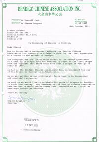
Document - BENDIGO EASTER FAIR COLLECTION: BENDIGO CHINESE ASSOCIATION LETTER RE CENTENARY OF DRAGON, 10th October, 1991
Letter from Bendigo Chinese Association Inc. to Dianne Cousins, Executive Officer, Bendigo Easter Fair Inc. PO Box 36, Bendigo, re Centenary of dragons in Bendigo. As far as the Bendigo Chinese Association Inc. is concerned the age of the Dragon in Bendigo is indeterminate. Signed Graeme Lougoon, Secretary. Dated 10th. October, 1991.bendigo, chinese, bendigo chinese association -
 Surrey Hills Historical Society Collection
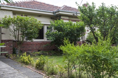
Photograph - 26 Albion Street, Surrey Hills, The Street Where You Live Project, 2014
Photos documenting this address as part of a photographic series undertaken by volunteer photographers during 2013 and 2014 for The Street Where You Live Project. This was organised through the Surrey Hills Neighbourhood Centre and covered the postcode 3127 in the cities of Boroondara and Whitehorse.These photos provide a snapshot of real estate in the suburbs of Mont Albert and Surrey Hills during a period of rapid change with many properties on large blocks demolished to create higher density residential development or renewal of single dwellings. At particular risk were properties not covered by heritage overlays, especially interwar housing and post 1950's housing. -
 Eltham District Historical Society Inc
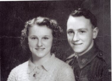
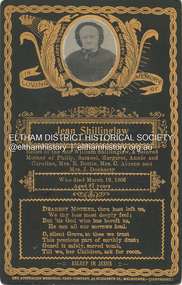
Photograph, The Australian Memorial Card Company, Memorial Card: Jean Shillinglaw, 1906
Died March 19, 1906 aged 87 years. A Colonist of 64 years, relict of the late William Shillinglaw and beloved mother of Phillip, Samuel, Margaret, Annie and Caroiline, Catherine Bottle (nee Shillinglaw), Sarah Aldous (nee Shillinglaw) and Elizabeth Docherty (nee Shillinglaw). Memorial Cards were commonly handed out to those friends and family paying their respects at the loss of a loved one. A duplicate is contained in the same album CABINET 1866-1905 The Cabinet photo was introduced in 1866 in answer to a demand for a larger format photograph which could be mounted for a cabinet or on the wall. They were 4.5 inches by 6.5 inches (11.5 x 16.5 cm), more than twice the size of the cdv. They cost about twice as much as a cdv but eventually displaced them. They were not extensively produced until 1880 and had ceased by 1905. Coloured mounts, especially maroon or green, indicate a date between 1880 and 1890. - Frost, Lenore; Dating Family Photos 1850-1920; Valiant Press Pty. Ltd., Berwick, Victoria 1991cabinet photo, marg ball collection, shillinglaw family photo album 3, 1906, ann shillinglaw (1861-1940), caroline (carrie) watson (nee shillinglaw) 1876-1956, catherine bottle (nee shillinglaw), elizabeth docherty (nee shillinglaw 1861-1942), jean shillinglaw (nee blemner 1819-1906), margaret shillinglaw, memorial card, phillip shillinglaw (1842-1914), samuel shillinglaw (1848-1925), sarah aldous (nee shillinglaw 1854-1925), the australian memorial card company, william shillinglaw -
 Eltham District Historical Society Inc
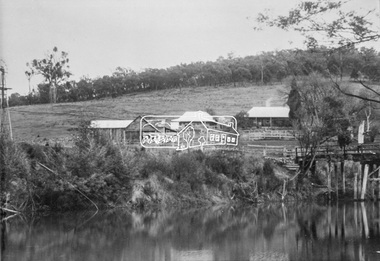
Photograph, Henley Bridge, c.1928
Situated on the Yarra River, 5.5 kms south of Christmas Hills on private property. This timber trestle bridge is said to have been built some time after 1907 by Melbourne master-builder, David Mitchell (the father of Dame Nellie Melba), to connect his two "Henley Farm" properties with Lilydale. In earlier days, when the McPhersons owned the property, their children used a punt to cross the river to attend Yering Primary School. This private bridge is best viewed from the end of Wendy Way. - Source: Christmas Hills Past and Present, Yarra Glen & District Historical Society, 2004.This photo forms part of a collection of photographs gathered by the Shire of Eltham for their centenary project book,"Pioneers and Painters: 100 years of the Shire of Eltham" by Alan Marshall (1971). The collection of over 500 images is held in partnership between Eltham District Historical Society and Yarra Plenty Regional Library (Eltham Library) and is now formally known as the 'The Shire of Eltham Pioneers Photograph Collection.' It is significant in being the first community sourced collection representing the places and people of the Shire's first one hundred years.9 x 12.5 cm printshire of eltham pioneers photograph collection, warrandyte, henley bridge -
Moorabbin Air Museum
Document (Item) - De Havilland DeH1 aircraft stories with line drawings (Photocopy)
-
 Bendigo Historical Society Inc.
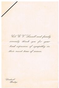
Document - COL. G V LANSELL SYMPATHY THANK YOU CARD
Cream sympathy card from Col. G. V. Lansell and family. A thank you for expressions of sympathy. Card has a mark across the top left corner. IN the bottom left corner is printed 'Denderah', Bendigo.person, individual, col g. v. lansell, document, col g v lansell sympathy thank you card -
 Melbourne Tram Museum
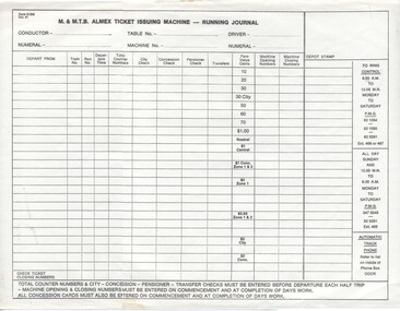
Document - Form/s, Melbourne & Metropolitan Tramways Board (MMTB), "M&MTB Alex Ticket Issuing Machine Running Journal", Oct. 1981
Printed form titled "M&MTB Almex Ticket Issuing Machine Running Journal" for use by Conductors or Bus Driver issuing Almex type tickets. Has the time of departure, tram number, counters, various checks, and fare values along with opening and closing numbers on the machine. Dated Oct. 1981.trams, tramways, tickets, conductors, revenue journal -
 Tatura Irrigation & Wartime Camps Museum
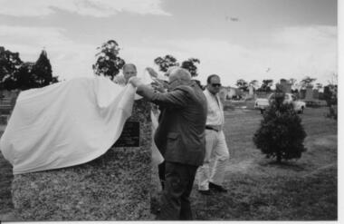
Photograph, Tatura Cemetery Unveiling Cairn
Original in colour, photograph of the unveiling Cairn at Tatura Cemetery by Tom Flanagan.tatura, flanagan t, cemetery, memorial, civic, memento, memorials, costume, male, transport, motor, vehicles -
 Melton City Libraries
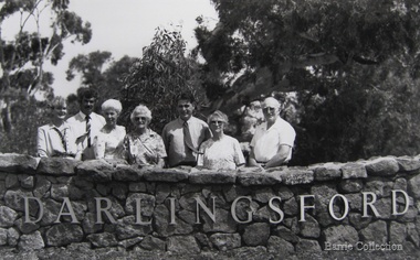
Photograph, Official opening of the Darlingsford Estate, 1994
Jennifer Coral Scott [Barrie] & Peter Barrie, Wendy Barrie, Edna Myers [Barrie], Vivienne Developments representative, Wilma Ryan [Barrie] & Jim Barrielocal identities, council -
 Ringwood and District Historical Society
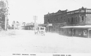
Photograph, Maroondah Highway Central, Ringwood. Main Street looking west. Adelaide St. corner on right. c1924
Photograph (3 copies- 2 large black and white, 1 sepia postcard) Typed below one of the photographs, "Maroondah Highway looking west. Shops to right now Eastland carpark. Shops in centre are opposite station entrance" Typed below other copy: "Main St. looking west. Adelaide St corner on right. c1924." Typed on sepia postcard copy: "Main Street, Ringwood, Victoria. Valentines Series. M4801." -
 Bendigo Historical Society Inc.
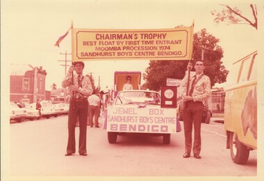
Photograph - SANDHURST BOYS CENTRE COLLECTION: MOOMBA PARADE 1974
Six photographs (four in colour and two black and white). The first photo shows two men carrying a banner: Chairman's trophy best float by first time entrant Moomba procession 1974, Sandhurst Boys Centre, Bendigo, in front of the car towing the float. The other photos show the float called "Miss Muffet" making its way through the streets of Melbourne.bendigo, institutions, sandhurst boys centre -
 Phillip Island and District Historical Society Inc.
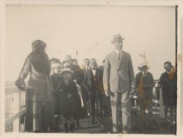
Photograph, Late 1920's early 1930's
One of 23 photographs from the Jessie Smith Collection. Donated by Stan McFee.Black & White photograph of Lord & Lady Stradbroke and family standing on the Cowes pier with a group of peopleOn Back: "Lord & Lady Stradbroke & family Cowes pier" signed J H Smithlord & lady stradbroke, cowes jetty, phillip island, jessie smith collection, stan mcfee -
Bialik College
Photograph (Item) - Lithographs on loan from Sandra Bardas, no date
Photographs on loan from Sandra Bardas showing lithographs loan to Bialik College in the condition in which they were loaned to the school. No date provided. For access or information regarding permissions, contact the archive at [email protected]. art, bialik college