-
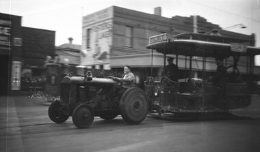 Melbourne Tram Museum
Negative, Wal Larsen, 1937c
Negative of a cable grip car being hauled by a tractor (in or out) of the South Melbourne tram depot or car sheds. Has the grip in the removed position. In the background is a hotel and a petrol or service station - out of focus. The grip car has the destination of Collins St on the front and "Connects with Collins St electric cars" on the side. Photographer could be Wal Larsen based on negative size - see Reg Item 5064.Written on rear of album print "Tractor hauling cable dummy out of South Melb. Sheds."trams, tramways, cable trams, south melbourne depot, grip tram -
 Stawell Historical Society Inc
Archive, Grand United Quartz Mine Journal, 1872 - 1874
Brown Cover - Gold Lettering on Red Square - "Journal"stawell, gold mining -
University of Melbourne, Burnley Campus Archives
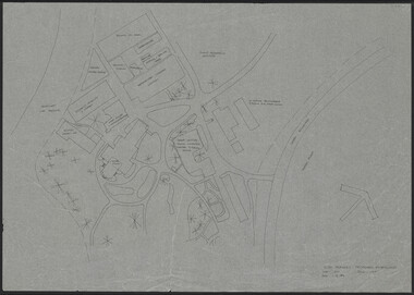
Plan, Blessington Street Gardens, 1983-1984
City of St Kilda plans. (1) Existing Conditions: NW Quadrant. Drawing No. 2135 File No 8-134. 1 of 4 Surveyed by Peter Herbert. Scale 1:250. (2) NE Quadrant. Drawing No 2136, 2 of 4. (3) SE Quadrant. Drawing No 2137, 3 of 4. (4) SW Quadrant. Drawing No 2138, 4 of 4. (5) Existing Conditions. Drawing No 2139, 1 of 1. Scale 1:500. (6) Redevelopment - Concept A. Designed by N. Hamey Sept '83 Scale 1:500. Drawing No 2140 1 of 2. (7) Tree Inventory. Surveyed by P. Herbert, traced by Greg Hocking Feb '84. Drawing No 2140, 1 of 2.st kilda, blessington street gardens, peter herbert -
Glenelg Shire Council Cultural Collection
Plan - Plan - CRB concrete handrail, n.d
Port of Portland Authority Archivesport of portland archives -
Stawell Historical Society Inc
Archive, S. Isaacson Store Main Street Stawell. Daily Sales Book, 1888 - 1889
Green naterial cover with red binding on spine and outer corner's. Label mostly missing Legible Print reads From S.ISAACS Family Draper Silk Mercer a From Feb MAIN stawell, business -
 Kew Historical Society Inc
Plan - Subdivision Plan, Central Park Estate, Deepdene - Camberwell, 1923
The Kew Historical Society collection includes almost 100 subdivision plans pertaining to suburbs of the City of Melbourne. Most of these are of Kew, Kew East or Studley Park, although a smaller number are plans of Camberwell, Deepdene, Balwyn and Hawthorn. It is believed that the majority of the plans were gifted to the Society by persons connected with the real estate firm - J. R. Mathers and McMillan, 136 Cotham Road, Kew. The Plans in the collection are rarely in pristine form, being working plans on which the agent would write notes and record lots sold and the prices of these. The subdivision plans are historically significant examples of the growth of urban Melbourne from the beginning of the 20th Century up until the 1980s. A number of the plans are double-sided and often include a photograph on the reverse. A number of the latter are by noted photographers such as J.E. Barnes.An agent’s board on which parts of an advertisement for the Central Park Estate have been pasted. [The State Library of Victoria holds a complete plan]. Whereas the original plan included black and white photographs and effusive prose about the virtues of the Estate, the item in our collection includes only the actual blocks. The agent has annotated particular blocks to indicate that they have been sold.subdivision plans - deepdene - camberwell, central park estate -
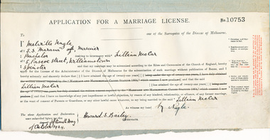 Mission to Seafarers Victoria
legal record (item) - Register, Application for a Marriage License, Circa 1929
This is a register of Application for a Marriage Licenses, dated from 15th of October 1929, to the 7th of September 1941 (although this license has not been dated, the actual wedding is recorded in the marriage register for 1941 to 1947).Each application in the register records the information needed to issue a license under Commonwealth law.marriage, wedding, license, 1929-1941, marriages, dio-marriages, marriage license, melville nagle, ss marana, lillian melar, mariner, williamstown -
Kew Historical Society Inc
Archive (series) - Subject File, Meals-on-Wheels, 2015
Kew Historical SocietySince its foundation in 1958, members of the Kew Historical Society have been compiling and storing information about subjects relating to the history of Kew and its environs, of which this file is an example. Arranged by Secondary Values (value of records to users)Subject file created by researchers of the Kew Historical Society containing primary and secondary sources relevant to the Meals on Wheels Service delivered through the Elderly Citizens Centre initially by the City of Kew and subsequently by the City of Boroondara. In addition to sundry newspaper clippings the file includes a list of drivers and a large pamphlet giving instructions to drivers about delivery. The collection also includes a number of additional items relating to the service.kew elderly citizens centre, meals on wheels, kew senior citizens, beverley piperkew elderly citizens centre, meals on wheels, kew senior citizens, beverley piper -
Stawell Historical Society Inc
Archive, Stawell High School. Ex Students reunion Committee Minute Book, 1981 - 1987
Meetings Held from 23-11-1981 to November 1982 to arrange reunion of Ex-Students to be held 15 & 17 1982. In the same book of minutesfor meetings held 5-121-1984 to 16-09-1987 for reunion to be 0n 9-10 Oct 1987.Ex-Students Reunion committee minute book. Pale Brown covered book.stawell, education -
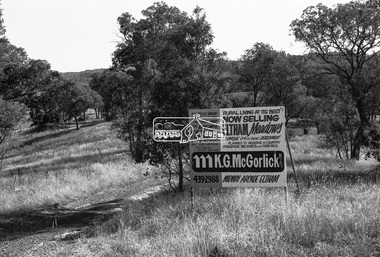 Eltham District Historical Society Inc
Negative - Photograph, Shire of Eltham, Eltham Meadows Estate, Zig Zag Road subdivision, Jan. 1980
eltham, eltham meadows estate, k.g. mcgorlick pty ltd, mcgorlick real estate, zig zag road subdivision -
Stawell Historical Society Inc
Archive, Cemetery Trust Stawell. Burials 1870 – 1938, Oct 1870 - Mar 16938
Grey/Green No title on cover. Records Fees Paidstawell, cemetery -
 Kew Historical Society Inc
Plan - Subdivision Plan, Old Kew Golf Links Estate - Third Section, 1920-1929
Pru Sanderson, in her groundbreaking ‘City of Kew Urban Conservation Study : Volume 2 - Development History’ (1988), summarised the periods of urban development and subdivisions of land in Kew. The periods that she identified included 1845-1880, 1880-1893, 1893-1921, 1921-1933, 1933-1943, and Post-War Development. These periods were selected as they represented periods of rapid growth or decline in urban development. An obvious starting point for Sanderson’s groupings involved population growth and the associated economic cycles. These cycles also highlighted urban expansion onto land that was predominantly rural, although in other cases it represented the decline and breakup of large estates. A number of the plans in the Kew Historical Society’s collection can also be found in other collections, such as those of the State Library of Victoria and the Boroondara Library Service. A number are however unique to the collection.The Kew Historical Society collection includes almost 100 subdivision plans pertaining to suburbs of the City of Melbourne. Most of these are of Kew, Kew East or Studley Park, although a smaller number are plans of Camberwell, Deepdene, Balwyn and Hawthorn. It is believed that the majority of the plans were gifted to the Society by persons connected with the real estate firm - J. R. Mathers and McMillan, 136 Cotham Road, Kew. The Plans in the collection are rarely in pristine form, being working plans on which the agent would write notes and record lots sold and the prices of these. The subdivision plans are historically significant examples of the growth of urban Melbourne from the beginning of the 20th Century up until the 1980s. A number of the plans are double-sided and often include a photograph on the reverse. A number of the latter are by noted photographers such as J.E. Barnes.When the old Kew Golf Links was subdivided in the mid 1920s, the developers were able to break the sale into sections. The third section included eighty lots. The lots faced Kilby Road, Kodak Avenue, Belford Road, Baker Avenue, Mathers Avenue, and White Avenue. [Kodak Avenue was renamed Page Avenue at a later date].The ‘Kew Conservation Study (1988) notes that ‘On the subdivision plan, Kodak’s involvement is commemorated by the naming of the streets after Company directors, and their decision to not proceed with the construction of the factory is explained as a response to the increase in the value of the land. This explanation may have been Estate Agent’s hyperbole, as the Kodak Company records suggest that the land, with its wide creek gully, was unsuitable and too small for its purposes.subdivision plans - kew, old kew golf links estate - third section -
 Eltham District Historical Society Inc
Negative - Photograph, Russell Yeoman, Cottles Bridge, c.1970
Roll of 35mm black and white negative film, 4 of 7 strips and corresponding B&W printIlford HP4bridge, cottles bridge, diamond creek (creek) -
Glenelg Shire Council Cultural Collection
Negative - Glass Plate Negative - Man in suit and top hat, cane. Inspecting construction site, 1890-1910
Glass plate negative. Image shows man in suit and top hat, cane. Inspecting construction site. -
Stawell Historical Society Inc
Archive, Gold Crushing Records – Stawell March 1862 to May 1880, 1862 - 1880
Bookstawell, mining -
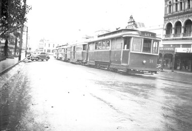 Ballarat Tramway Museum
Negative, Wal Jack, Late 1930's to mid 1940's
Yields information about the use of the City Loop during the late 1940s.Negative and Digital image of the Wal Jack Ballarat Negative file of a group of trams (3 single truckers and one bogie car) in City Loop late 1940's or early 1950s. Tram 31 (City) is at the head of the line up on a wet day. In the background is the Ballarat Gas Company building.trams, tramways, city loop, sturt st, tram 31 -
 Eltham District Historical Society Inc
Negative - Photograph, Skipper House/Studio, Dalton Street, Eltham, 5 June 1990
Matcham Skipper's home behind Whitecloud Cottage (formerly Jarrold Cottage) Eltham built landscape Elevated studio/house built by Matcham Skipper and other family membersRoll of 35mm colour negative film, 7 stripsFuji 200 Aeltham, buildings, houses, matcham skipper, 1990, artists, dalton street, film - fuji 200a, scan - 35mm negative, skipper -
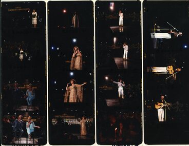 Vision Australia
Negative - Image, Henk Rem, Performers on stage at the 1979 Carols by Candlelight performance
Brian Naylor and (possibly MP Jeannette Patrick, Paul Meenie and Linda George, Margaret Nesbitt, Kirri Adams and Franciscus Henri at the 1979 Carols by Candlelight.Colour transparencies taken at Carols by Candlelightcarols by candlelight, brian naylor, paul meenie, linda george, margaret nisbett, kirri adams, franciscus henri -
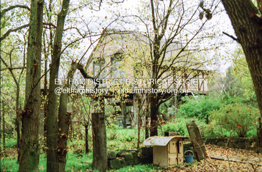
 Eltham District Historical Society Inc
Negative - Photograph, Harry Gilham, Graves of William J and Mary Jane (nee Vance) Crozier and their sons Thomas Vance and John McClelland Crozier, Eltham Cemetery, Victoria, 1 Aug 2007
William Crozier was born 1823 in County Armagh, Ireland. Mary Jane Vance was born 1829 in Desecrete, County Tyrone, Ireland. They were married in 1848. On New Year's Eve, 1849, together with their baby daughter Sarah, William and Mary embarked from Plymouth aboard the Eliza Caroline, as assisted immigrants, for Port Phillip, arriving 31 March 1850 from where they journeyed out to Eltham on a bullock wagon. The Croziers were Episcopalians and soon after arriving in Eltham the Wesleyans of Little Eltham were holding services in the Crozier's home, among other locations. It was not until January 1856 that the Wesleyan church first acquired land in Henry Street for a chapel, which later became the home of the Eltham Hall. The Crozier home, known as ‘Belmont’ was weatherboard with a rammed earth floor. It was situated on twenty-four acres along the track at its rise, about half-a-mile east of Maria Street (Main Road) bounded by Mt Pleasant Road on the south and Pitt Street northwards. William Crozier used the land for cultivation and grazing. The track the Eltham Wesleyans took, by foot or horse, was along the Mt Pleasant Road, and like most roads of the time, a dusty trail in summer and a hoof and cart rutted quagmire in winter. William and Mary Crozier had seven children: Sarah, (1848 Ireland), John McClelland (1851 Eltham), Eliza (1855 Eltham), William (1857 Eltham), Jane(1859 Yarraville), Charlotte Amelia (1861 Yarraville), and Thomas Vance (1864 Eltham). The Crozier farm prospered and in 1870, William applied for, and was granted a leasehold on an additional sixty-three-acre selection, half-a-mile east of his twenty-four-acre Mt Pleasant Road property. Upon this property he built a two-roomed dwelling of slats and bark and a storeroom of log and bark, ten feet square. In 1880 he applied for a Crown grant of the property. Tragedy struck the family in 1882 when the youngest, Thomas Vance at age 17 accompanied by John Anderson, went into "Hall's Dam" to bathe, neither of them being able to swim. On wading out together, Crozier suddenly slipped into a part about 10ft. deep, and sank, after rising only once. Anderson pluckily tried to save him, nearly losing his own life in the attempt, saving himself when sinking for the last time by seizing hold of a projecting root. The body was not recovered until two hours after, when Mr. Thomas Bell, a farmer in the locality, who was attracted to the spot, on hearing of the occurrence, although unable to swim, plunged in with a rope around his waist, and succeeded with some difficulty in bringing it to the surface. Their eldest son, John also died prematurely at age 42 when he was killed by a falling tree branch whilst engaged in ring-barking trees at Eltham. A still cold wind was blowing and John, and others who were working with him, sheltered themselves at lunch time by sitting on the side of a large tree. When thus seated, the wind detached a limb of the tree which sheltered them, and though they heard the cracking, they had not time to get clear before the limb fell. It struck John on the head, and felled him to the ground, He appeared to be suffering severe pain, and two of his companions conveyed him to the Melbourne Hospital, where during the night he was operated upon for a fracture of the skull. Despite the operation being successful, John ultimately succumbed to his injuries the following afternoon. In good times William was known for his wealth of reminiscences of the early days of the district however his health failed him for several years until his death in March 1909. He was a man of very industrious habits, of a retiring disposition and much esteemed by those who knew him best. Mary died in January 1915 after a long illness. They are buried together along with their sons John and Thomas in the Eltham Cemetery. In Loving Remembrance William Beloved husband of Mary Jane Crozier Who departed this life March 31st 1909, aged 85 years Also Mary Jane Beloved wife of the above Who departed this life January 3rd 1915, aged 86 years Also John McCelland Son of the above Who departed this life May 20th 1894, aged 42 years also Sacred Memory of Thomas Vance Dearly beloved son of William J. Crozier Who departed this life at Eltham, February 3rd 1882 Aged 17 yearseltham cemetery, gravestones, memorials, film - kodak gold gc 400-9, john mccelland crozier, mary jane crozier (nee vance), scan - 35mm negative, thomas vance crozier, william crozier, william j crozier -
Federation University Historical Collection
Negative, Mt Helen Campus Students Sit Near the Tree of Knowledge, 1993
tree of knowledge, alumni, mt helen campus -
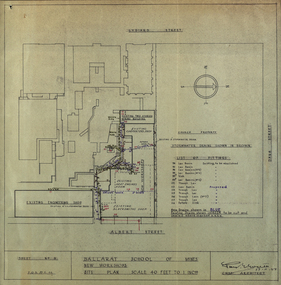 Federation University Historical Collection
Plan - Plans, Ballarat School of Mines New Workshops, 1944, 17/11/1944
This building has been demolished to make way for new buildings along Albert Street. According to E.J. Barker this was Metal Fabrication.Plans (dyeline) for new building along the Ballarat School of Mines Albert Street frontage .1) Ballarat School of Mines New Workshops .2) as above Scale 1:480 WGS 84 37 degrees 33 feet 54 inches south 143 degrees 50 feet 30 inches eastSheet No 3 F.G.B.ballarat school of mines, metal fabrication, albert street, buildings, plan, heat engines room, model mine, blacksmiths shop, blacksmithing, carpenters shop, engineering shope, percy everett -
Kew Historical Society Inc
Archive (Sub-series) - Subject File, Kew Historical Society, GRIMES, Charles, 1962
Various partiesReference, Research, InformationSecondary Values (KHS Imposed Order)Charles Grimes was acting Surveyor-General of the Colony of New South Wales. He was the first European cartographer to map the lower reaches of the Yarra River. The reference file contains both research on the ‘exploration’ by Grimes as well as information on a re-enactment, sponsored by the Kew Historical Society in 1978, to mark the 175th year of his party’s arrival in the area of what is now Dight’s Falls. In the file is a 13-page handwritten document to be used as a script for a speech during the reenactment, which also includes details of the costumes to be worn. There are additional unpublished manuscripts in the file about Grimes and his ‘journey’ by Mr Chinner and Mavis Rolley. The file also includes newspaper articles/clippings as well as sundry published articles.charles grimes, commemorations - kew (vic.), european exploration - kew (vic), yarra river - historycharles grimes, commemorations - kew (vic.), european exploration - kew (vic), yarra river - history -
 University of Melbourne, Burnley Campus Archives
Plan, VCAH Burnley Proposed Extensions, 1984
Sketch on tracing paper by JWP dated 01.11.1984. Scale 1:500.vcah, burnley -
Port Melbourne Historical & Preservation Society
Negative - All England Eleven Hotel, Melbourne and Metropoltan Board of Works, 1950
2 oblong negatives of the "All England Eleven Hotel"built environment - commercial, hotels, all england eleven hotel -
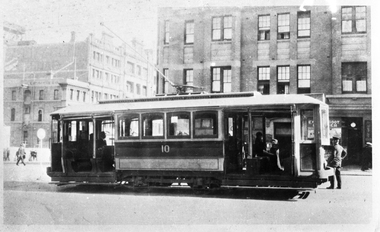 Melbourne Tram Museum
Negative, Wal Jack collection, 1924/25
Black and white copy negative of a photo of MMTB A class No. 10 in Swanston St, c1924/25. Rod Atkins advised 11/10/2020: Confirmed A10 is in Swanston Street at Lonsdale Street facing north. The building behind the tram still stands today on the north west corner together with two large buildings in Lonsdale Street. These two were formerly part of Myer and now form part of The Emporium today. Photo appears in the Ray Pearson album with the above date. Shows the California Combination layout,trams, tramways, a class, swanston st, tram 10 -
 Federation University Historical Collection
Plan, Burrumbeep, 1884, 16/10/1884
Auctions of Crown land were introduced in the Colony of Victoria from 1851 to encourage settlers to occupy and work the land. Many squatters purchased land at auction at the upset (minimum) price of £1 per acre. In some areas where demand was high, such as the goldfields, the price realised at auction was much more. Land was put up for sale in the study area on the Burrumbeep run in May 1855, on the Lexington run in 1857, and on the Gorrinn run in 1858. (http://www.ararat.vic.gov.au/library/document/thermatics.pdf, accessed 27 January 2015) For 70 years or more, Yalla-y-Poora, Burrumbeep, Edgarley, Mount William and Narrapumelap ranked in the leading wool producers in Victoria. 1 Stud owners at Yalla-y-Poora, Eurambeen, Burrumbeep and Challicum crossed merino sheep with sheep descended from John Macarthur's Camden Park in New South Wales. (http://www.ararat.vic.gov.au/library/document/thermatics.pdf, accessed 27 January 2015) In what was to become the Ararat Mining Division, gold was discovered in May 1854 on the Burrumbeep run at a place that became known as Pinky Point on the Mount William goldfield. By 21 June 1854, between 600 and 1,000 people had arrived. (http://www.ararat.vic.gov.au/library/document/thermatics.pdf, accessed 27 January 2015)\ Town allotment plan for Burrumbeep. Merrymbuela, Borung, Lexington and Langi Logan are neighbouring areas. The plan includes the Burrumbeep Pre-Emptive Right (Roger and Wright); licensed land holders including Stephen Young, John Carroll, William Walsh, Thomas Purcell, Martha M. Bond, Colin Johnson, John Charles Webb, Henry Withycombe, William Henry Barbridge, John Wall, Thomas Flatelly, William Jenkinson, Elisia Radford, V. Radford, Denis Byrne, George Cook. Land holders included Andrew Maloney, Richard Wingfield Harrocks, W. Sporton, Terence Lynch, F. S. Falkiner, A. Millman, H. Morris, George Upham, J. McCLure, S. Fletcher, W. Parker, Thomas Myers, William wright, W.C. Winter, C. Wordman, Oliver A. Winter This plan is associated with former Ballarat School of Mines student Richard Squire (1875-6) Gift of the Squire FamilyVerso written in pencil - Plan of Burrembeep Ararat Burrembeep Araratburrumbeep, corrinn, langi logan, merrymbuela, lexington, ararat, roger & wright, cook, rogers, upham, george upham, ross, parsans, morris, johnson, withycoombe, colin johnson, falkiner, dsporton, john carroll, donald gordon, denis bryne, maurice dooley, martha bond, william harricks, \william wingfield harricks, william l.c. harricks, michael houlihan, thomas purcell, martin ryan, michael cody, fletcher, mccaw, w. parker, j.m. clow, elisia radford, thomas radford, thomas myers, barbridge, e. wilde, j. wall, flatelly, g. wardman, w.c. winter, david ball, jenkinson, ballarat school of mines, richard squire, squire -
 Ringwood and District Historical Society
Archive, Lands Department Field Notes, Ringwood 1878-1955 (Parent Record)
This record is the Parent Record for contents of folder "Lands Department - Survey of Field Notes of Ringwood Area". -
Port Melbourne Historical & Preservation Society
Plan - Concept, Boulevard upgrade at Sandridge Beach, traffic treatment, 2003
Plans. Traffic treatment. Concept for the Boulevard upgrade at Sandridge Beach. Dated October 2003local government - city of port melbourne, engineering - roads streets lanes and footpaths -
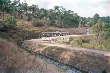 Eltham District Historical Society Inc
Negative - Photograph, Maroondah Aqueduct, Kangaroo Ground, 1991
Roll of 35mm colour negative film, 9 strips Colour print 10 x 15 cmFuji HG 200 CA-1kangaroo ground, maroondah aqueduct -
Stawell Historical Society Inc
Archive - CD/DVD, Pioneer Index Victoria 1836-1888 - Database Index Births Deaths Marriages
stawell