-
 Stawell Historical Society Inc
Archive, et al, Flying Doe Reefing Coy 1868 - 1871. Front Section holds details of S. Isaacson Store Daily Sales, 1868 - 1871
Pages 1-117 (Back Section) Have been photocopied and are stored in the "Flying Doe" Mines File Rm2Green Cover Red Bound Bookstawell, mining, business -
 Bacchus Marsh & District Historical Society
Map, Lerderderg Park Lands sale plan. 1911
This plan was for the sale of parcels of land from the Lerderderg Park Estate property in 1911. Advertising for the sale appeared in the Bacchus Marsh Express newspaper through July of 1911. The property was situated only a few kilometers from the township of Bacchus Marsh. The agents for the sale were L. A. Fairbairn & Co.Lerderderg Park Estate was a significant and early colonial property in the Bacchus Marsh area. This plan provides details about the first time the property was subdivided for sale. It is therefore documents an important moment in the history of this property and the broader trend of the subdivision of older and larger properties in the district.A single page paper plan showing allotments of land for sale from the Lerderderg Park property owned by John Wills. The parcels of land for sale are coloured in red.The Lerderderg River and Pyke's Creek Irigation Channel shown on the plan are in blue ink. The rest of the plan is a dark cream or beige colur with the text in black ink. The plan has been extensively annotated with hand-written notes indicating the names of people who purchased the various parcels of lands and the prices paid for those lands. Part of the top of the plan containing some text appears to be missing. The plan is pasted into a bound volume containing 76 maps or plans in total. Top: Have received instructions to Sell, account Mr John Wills, his renowned LERDERDERG PARK LANDS, so well and favourably known throughout the Commonwealth. In areas from 3 acres to 1276 acres. Every lot is either rich lucerne land (or portion now under lucerne) with some higher land adjoining Railway Station, and 2 Milk factories within 2 miles, absolutely the finest land in Victoria. Bottom: THIS IS THE FIRST SUBDIVISIONAL SALE of Rich Flats in Bacchus Marsh since the Pyke's Creek Scheme, and every lot is commanded by it. Only 32 miles from Melbourne.bacchus marsh victoria maps, land sales, lerderderg park estate, land subdivision -
Stawell Historical Society Inc
Archive - Book, Registration of Residence Area 24-9-1906 - 9-11-1910, 1897
Resident Areas Miners Right Also Cat No 4235-10 Local GovernmentLarge Navy Blue Ledger Book with Red Spine and corners General Register 8P -
Moorabbin Air Museum
Manual (Item) - Australian Airlines Boeing 737-400 Flight Crew Operations Manual Volume 3
-
Moorabbin Air Museum
Plan (item) - C.A.C Plan XP.64
-
Moorabbin Air Museum
Manual (item) - Instrument Rating Course, Instrument Rating Course Part 4- sample test guide
-
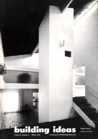 Robin Boyd Foundation
Journal, Jeffrey Turnbull, Building Ideas, Vol 5 No 5, 1973
Volume entitled 'Robin Boyd Visions of Living', compiled by Jeffrey Turnbull in memory of Robin Boyd. It contains excerpts from 'Living in Australia' published as a tribute following Boyd's death.building, architecture, jeffrey turnbull, walsh st library, tribute -
Moorabbin Air Museum
Manual (item) - AAP 7212.005.1CL Flight Crew Check List CT-4A Airtrainer
-
Moorabbin Air Museum
Manual - REDIFON DC9 Interface Tech Manual
-
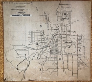
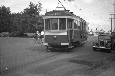 Ballarat Tramway Museum
Negative, Wal Jack, late 1945
Yields information about the appearance of the ex Melbourne bogie trams during the initial period of operations in Ballarat.Negative and Digital image of the Wal Jack Ballarat Negative file of bogie car, most likely ex Melbourne 117, future 22 at the intersection of Wendouree Parade, Ripon and Webster Streets. Tram has the destination of city. Late 1945. It would appear that the sides of the tram have been painted but not the rear end, still has the MMTB War time markings on the tram. trams, tramways, wendouree parade, new trams, webster st, ripon st, bogie trams, tram 22 tram 117 -
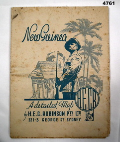 Bendigo Military Museum
Map - MAP, NEW GUINEA, H.E.C Robinson PTY LTD, Post WW2
Map Robinsons “Territory of New Guinea and Papua” 0ff white colour rectangular shape, shows New Guinea, Papua, New Britain, New Ireland & Bougainville, colours red, orange, yellow, green designating boundaries, when folded one section has in blue a depiction of An Australian Soldier with palm trees & native hut.“Map No 315”maps, new guinea, robinsons -
Stawell Historical Society Inc
Archive, South Cross Reef Gold Mine Co Ltd – Share Register. Call and Transfer Book, 1873 - 1874, 1876 - 1878
Heavy Card Cover - Leather Trim. Fawn in ColourThe South Cross Reef G.M. Co Limitedstawell -
Moorabbin Air Museum
Manual (Item) - Sidewinder 1A Missile (Air Force)
Description: Photographs short Brothers A/C History of short aircraft Pages: 20 Author: Short and Various Level of Importance: . -
Moorabbin Air Museum
Manual (Item) - CAC Winjeel Flight Manual Dual Trainer, Flight Manual Winjeel Dual Trainer
Commonwealth Aircraft Corporation -
Moorabbin Air Museum
Manual (Item) - Atar Engine Overhaul Manual Inspection - Plates
Description: 180 pages. Published by SNECMA/RAAF. Published with materials from 1967-1969. AAP 711.55 Vol. 6/Part 4 (TEXT) Level of Importance: World. -
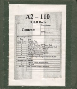 National Vietnam Veterans Museum (NVVM)
Manual, A2 - 110 TOLD Book
A green plastic foldre with white paper stuck on the front. On the white paper there is lots of information in a table format in black in.passenger safety briefing, aircraft -
 Ballarat Tramway Museum
Map, General Accident Fire and Life Assurance, "Sketch Map of Ballaarat including Ballaarat East and Sebastopol", c1940
Yields information about Ballarat c1940 and how the area was rate for insurance purposes.Map - paper mounted onto a heavy card backing titled "Sketch Map of Ballaarat including Ballaarat East and Sebastopol" with a printed label "General Accident Fire and Life Assurance" pasted to the top of the title. Drawn at 30chains to the inch. Map shows the boundaries between the carious insurance classifications in the district, which relates partly to the local government areas at the time. Shows the Yarrowee, Gong Gong Creeks, rail lines, stations, Black Hill and some other features. Includes the Explosives factory area. Does not show the tram lines.trams, tramways, ballarat, maps, insurance, sebastopol -
National Vietnam Veterans Museum (NVVM)
Journal, Canungra Vietnam Memorial Newsletter
veterans – australia – periodicals, vvaa - canungra sub-branch -
Moorabbin Air Museum
Manual (Item) - General Electric Training Guide CT58-100 T58-GE8 SE106
-
Port Melbourne Historical & Preservation Society
Plan - Immigration sculpture, Beacon Cove, Orchard Design Studio, Mark Weichart, 1998
Mirvac, Beacon Cove developers, commissioned this sculpture. Orchard Design Studio contacted PMH&PS for 19th Century migrant ship names, to be handcarved into jarrah portion of sculpture, and for approval of 20th century ship names for the steel section. In return we requested a copy of these plans.Presentation plans (two sheets) for sculpture at Beacon Cove, designed by Orchard Design Studio of Pakenham. One in full colour, one a photocopy only. Subject: immigration.Photocopy signed by the artist, Mark Weichart.piers and wharves - station pier, immigration, transport - shipping, arts and entertainment - visual arts, mark weichart, mirvac, sculpture, orchard design studio -
Moorabbin Air Museum
Manual (Item) - RAAF Meteor 8 aircraft servicing forms, Royal Australian Air Force Aircraft Servicing Form Meteor Mk.8
RAAF -
Bendigo Historical Society Inc.
Map - CAMPBELL COLLECTION: BENDIGO AND DISTRICT MAPS, March 1947
Map. Mandurang, County of Bendigo, Sandhurst, Strathfieldsaye, Sedgwick, Sutton Grange, Ravenswood, Lockwood. Scale 40 chains to 1 inch. Drawn and reproduced at the Department of Lands and Survey, Melbourne, March 1947, price 2/-. By Authority : J.J. Gourley, Government Printer, Melbourne. (number 402 in map cupboard 1)J.J. Gourley, Government Printer.map, bendigo, allotments -
University of Melbourne, Burnley Campus Archives
Plan, Road Diversions, 1881-1889
Sketch plan of Burnley College grounds showing road diversions in 1881 and 1889.burnley college -
Moorabbin Air Museum
Manual (Item) - Government Aircraft Factories - Brochure And Products
Description: 10 pages. Published by WRF. Published October 1969. Accident Investigation Research with Necessary Recommendations Level of Importance: World. -
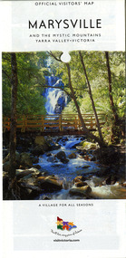 Marysville & District Historical Society
Map (Item) - Map and touring guide, Murrindindi Regional Tourism Association Inc, MARYSVILLE AND THE MYSTIC MOUNTAINS YARRA VALLEY-VICTORIA, Unknown
A fold out map and touring guide of Marysville and the surrounding district published by Murrindindi Regional Tourism Association Inc.A fold out map and touring guide of Marysville and the surrounding district published by Murrindindi Regional Tourism Association Inc.marysville, victoria, australia, map and touring guide, the cumberland, murrindindi regional tourism association inc, abbey green b&b, amberview lodge, anastasia fairytale cottage, ashlar cottage b&b, blackwood cottages, camellia log cabin, crossways country inn, dalrymples guest cottages, eagle mountain retreat, esa camping and conference centre, fruit salad farm, gilberts restaurant, keppels hotel motel, kerami house, kooringa resort and conference centre, lomatia lodge, lyelll guest cottages, marylands country house, marylyn holiday resort, marysville caravan park, marysville visitor information centre, alpacas at carmyle farm, australian adventure experience, bruno's art and sculpture garden, buxton trout farm, country touch tours, lake mountain, lake mountain ski hire, manical mechanicals, marysville district country club, marysville ski centre, rubicon valley horse riding, things of sand & stone, clearstream olives, the old woolshed cafe, fraga's cafe restaurant, lake mountain resort bistro, mantirri blueberry farm, gallipoli park, keppels lookout, cambarville, lady talbot drive, cathedral range state park, steavenson falls, steavenson river, taggerty river, acheron river, marysville auto and hardware, marysville newsagency & general store, narbethong visitor information centre, visit victoria -
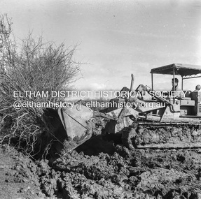 Eltham District Historical Society Inc
Negative - Photograph, J.A. McDonald, Kangaroo Ground-Queenstown Road, Aug. 1960
(Kangaroo Ground-St Andrews Road) “Rymers” Corner – shifting Hawthorn hedges on Tompkins property Council’s Drott 6 Woods Drott 9 August 1960 Showing method of lifting clumps of HawthornRecord of various Shire of Eltham infrastructure works undertaken during the period of 1952-1962 involving bridge and road reconstruction projects, sometimes with Eltham Shire Council Project Reference numbers quoted. It was during this period that a number of significant improvements were made to roads and new bridges constructed within the shire that remain in place as of present day (2022). In many situations, the photos provide a tangible visible record of infrastructure that existed throughout the early days of the Shire. The album was put together by or under the direction of the Shire Engineer, J.A. McDonald.infrastructure, shire of eltham, 1960-08, garden hill, kangaroo ground, kangaroo ground-queenstown road, kangaroo ground-st andrews road, rymers corner, bulldozer, drott -
Moorabbin Air Museum
Manual (Item) - Qantas B737 Flight Simulator Training Manual Revision No.10
-
Moorabbin Air Museum
Archive (Item) - Box Baa 81 Boeing (Gaf / Asta) Collection
Description: - Jindivik drawings TAD 4831 to 5465 Level of Importance: National. Historical Details: DAP/GAF/ASTA constructed many overseas designs under licence in Australia (Beaufort, Beaufighter, Lincoln, Canberra and F18) however they also designed and constructed a number of significant local designs that were successful in oversea's markets includi -
Bendigo Historical Society Inc.
Map - POWLETT : COUNTY OF BENDIGO, 2-12-15
Map. Powlett, County of Bendigo, County of Gladstone, Janiember West, Janiember East, Yarrayne, Salisbury West, Kurting, Korong, River Loddon. By Authority Albert J. Mullett, Government Printer, Melbourne. Photographed at the Department of Lands and Survey, Melbourne by W. J. Butson.2-12-15. Price 1/-. (number 119 in map cupboard 1)Albert J. Mullett, Government Printermap, bendigo, powlett -
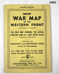 Bendigo Military Museum
Map - WAR MAP WESTERN FRONT, Geographer's Map Co Ltd, c.WWII
Folded map fixed into yellow cardboard folder with black printing. Map covers battle areas late in WWII of Maginot Line & Siegfried Line from Metz, France to Karlsruhe, Germany.On cover in black print: “Second Edition. New War Map of the Western Front”map, seigfreid, maginot