-
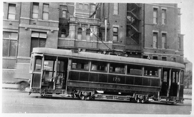 Melbourne Tram Museum
Negative, Wal Jack collection, mid 1920's
Black and White copy Photograph of T179 in Swanston St with the then Melbourne General Hospital behind.trams, tramways, t class, swanston st, tram 179 -
 Port Melbourne Historical & Preservation Society
Plan - Furniture, Council Chamber, Port Melbourne Town Hall, Port Melbourne City Council, 8 Jul 1938
Plan for Council Chamber furniture, 1938port melbourne town hall, city engineers, fred cook -
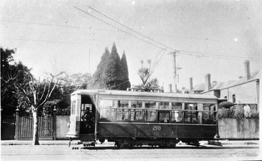 Melbourne Tram Museum
Negative, Wal Jack collection, 1923/24
Black and white copy negative of a photo of MMTB Birney 218 in Power St, soon after entering service in1923. Has the Bow Pantograph or Bow Collectors.trams, tramways, x class, birney, power st, bow pantograph, bow collector, tram 218 -
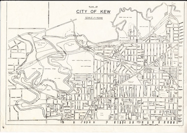 Kew Historical Society Inc
Plan, City of Kew, 1979
Plan of the City of Kew produced for public distributionPlan of City of Kew - Scale 1 : 15000Revised June 1979plans - city of kew (vic.), maps - kew (vic.), local government area - kew - victoria, cartography -
Stawell Historical Society Inc
Archive - CD/DVD, Bell family images and info. Family reunion photographs and brief history, 2013/2014
stawell -
Stawell Historical Society Inc
Archive, Rotary Club of Stawell Archives
Archives in 3 Drawers.clubs -
 Kew Historical Society Inc
Plan, Melbourne & Metropolitan Board of Works : Borough of Kew : Detail Plan No.1570, 1905
The Melbourne and Metropolitan Board of Works (MMBW) plans were produced from the 1890s to the 1950s. They were crucial to the design and development of Melbourne's sewerage and drainage system. The plans, at a scale of 40 feet to 1 inch (1:480), provide a detailed historical record of Melbourne streetscapes and environmental features. Each plan covers one or two street blocks (roughly six streets), showing details of buildings, including garden layouts and ownership boundaries, and features such as laneways, drains, bridges, parks, municipal boundaries and other prominent landmarks as they existed at the time each plan was produced. (Source: State Library of Victoria)This plan forms part of a large group of MMBW plans and maps that was donated to the Society by the Mr Poulter, City Engineer of the City of Kew in 1989. Within this collection, thirty-five hand-coloured plans, backed with linen, are of statewide significance as they include annotations that provide details of construction materials used in buildings in the first decade of the 20th century as well as additional information about land ownership and usage. The copies in the Public Record Office Victoria and the State Library of Victoria are monochrome versions which do not denote building materials so that the maps in this collection are invaluable and unique tools for researchers and heritage consultants. A number of the plans are not held in the collection of the State Library of Victoria so they have the additional attribute of rarity.Original survey plan, issued by the MMBW to a contractor with responsibility for constructing sewers in the area identified on the plan within the Borough of Kew. The plan was at some stage hand-coloured, possibly by the contractor, but more likely by officers working in the Engineering Department of the Borough and later Town, then City of Kew. The hand-coloured sections of buildings on the plan were used to denote masonry or brick constructions (pink), weatherboard constructions (yellow), and public buildings (grey). Plan No.1570 shows the layout of gardens and houses in Sackville Street, Davis Street, Wrixon Street, and Fitzwilliam Street in 1904. While Thomas Street is included on the map, at this stage no houses had been built. The plan identifies two named houses: ‘Fairview’ and ‘Kylemore’. Fairview is more fully delineated in Plan No.1563. Kylemore is one of the few houses in Kew designed by John Beswicke. The most notable owner of Kylemore was William Whitehead, who owned the house between 1895 and 1900. In 1894, Australian newspapers reported the marriage of Whitehead’s daughter to Dr. Gerald Eugene Cussen, the brother of Sir Leo Cussen, the Supreme Court Judge. The married couple was to live at ‘Wilton’ (now the Kew RSL) from 1911-15.melbourne and metropolitan board of works, detail plans, mmbw 1570, cartography -
Stawell Historical Society Inc
Archive - CD/DVD, Immigration to Victoria 1852-1879 - Database Index
stawell -
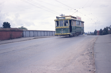
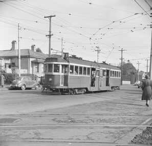
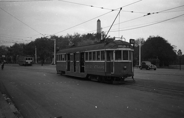 Melbourne Tram Museum
Negative, Wal Jack, c1945
Black and white negative, by Wal Jack, W2 585 (Darling Road Route 4D) at Domain Junction and a SW6 with dash canopy light (White stripe), route 7, City. The W2 has on the side "Subscribe Now Victory Bonds Speed Victory Buy 5/- Stamps" Photo c1945? May be earlier.trams, tramways, domain junction, world war 2, w2 class, route 4d, darling rd, route 7, sw6 class, tram 585 -
 Ballarat Tramway Museum
Negative, Travis Jeffrey, 5/08/1962 12:00:00 AM
Colour Negative No. N406, of the Bendigo No. 7, showing Quarry Hill, crossing over the railway bridge, in Mitchell St with the railway bridge structure in the background. Tram has a Castrol Oil roof advertisement. Photo taken possibly on 5/8/1962. Colour laser printed copy of image stored in box 73. Original negative hires scan and image updated 28/5/2020.In red pen on folder that contained negative, "NR96B" and "5 Aug 62". trams, tramways, bendigo, railway station, mitchell st, tram 7 -
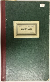 Kew Historical Society Inc
Archive (sub-series) - Administrative record, Minute Book, 1965-1968
Auburn Heights Tennis Club > Kew Heights Sports Club > MCC Kew Sports Club > Kew Historical SocietyAdministrative recordProvenance orderAuburn Heights Tennis Club - Bound Records of Meetings 1965-1968auburn heights recreation club - barkers road - kew (vic), auburn heights tennis club - barkers road - kew (vic) - minute booksauburn heights recreation club - barkers road - kew (vic), auburn heights tennis club - barkers road - kew (vic) - minute books -
 Kew Historical Society Inc
Plan - Subdivision Plan, Jas R Mathers Son & McMillan, Clifton Estate, Kew, c. 1916
Pru Sanderson, in her groundbreaking ‘City of Kew Urban Conservation Study : Volume 2 - Development History’ (1988), summarised the periods of urban development and subdivisions of land in Kew. The periods that she identified included 1845-1880, 1880-1893, 1893-1921, 1921-1933, 1933-1943, and Post-War Development. These periods were selected as they represented periods of rapid growth or decline in urban development. An obvious starting point for Sanderson’s groupings involved population growth and the associated economic cycles. These cycles also highlighted urban expansion onto land that was predominantly rural, although in other cases it represented the decline and breakup of large estates. A number of the plans in the Kew Historical Society’s collection can also be found in other collections, such as those of the State Library of Victoria and the Boroondara Library Service. A number are however unique to the collection.The Kew Historical Society collection includes almost 100 subdivision plans pertaining to suburbs of the City of Melbourne. Most of these are of Kew, Kew East or Studley Park, although a smaller number are plans of Camberwell, Deepdene, Balwyn and Hawthorn. It is believed that the majority of the plans were gifted to the Society by persons connected with the real estate firm - J. R. Mathers and McMillan, 136 Cotham Road, Kew. The Plans in the collection are rarely in pristine form, being working plans on which the agent would write notes and record lots sold and the prices of these. The subdivision plans are historically significant examples of the growth of urban Melbourne from the beginning of the 20th Century up until the 1980s. A number of the plans are double-sided and often include a photograph on the reverse. A number of the latter are by noted photographers such as J.E. Barnes.The Clifton Estate was an ambitious subdivision. It included 61 allotments bordering Cotham and Park Hill Roads, and Florence and Adeney Avenues. It is difficult to ascertain the exact year when the ‘Clifton Estate’ was surveyed, subdivided and first auctioned. The uncertainty may be due to allotments being released during the First World War. The subdivision took its name from the house ‘Clifton’ (lot 5) on the corner of Adeney Avenue and Cotham Road. The outline of Clifton (since demolished) and the extent of its land following the subdivision are represented on the plan. The auctioneers have also shown ‘Maryfield’ and ‘Wimba’, the neighbouring properties in Cotham Road, on the plan."B"subdivision plans - kew, clifton estate, cotham road, adeney avenue, florence avenue, park hill road -
Stawell Historical Society Inc
Archive, Callawadda Progress Association. Expenditure Receipts 1915 – 139, 1915 - 1939
stawell -
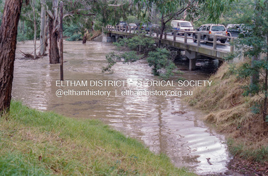 Eltham District Historical Society Inc
Negative - Photograph, Diamond Creek floodwaters near Main Road Bridge, Eltham, Feb. 2005
Flooding of the Diamond Creek in February 2005Roll of 35mm colour negative film, 7 strips Associated colour print 10 x 15 cmKodak GC400-8bridge, diamond creek (creek), eltham, eltham south, floods, main road, main road bridge -
Ringwood and District Historical Society
Legal record - Conditions of Sale (C.E.Carter), Ringwood - Lot 56, Plan of Subdivision No 8198, A Wigley to F Dark, 1925
Particulars and Conditions of Sale of Property , from A Wigley to F Dark -
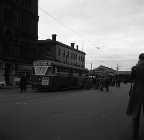 Ballarat Tramway Museum
Negative - Set of 2, Geoff Grant, 25/06/1955 12:00:00 AM
Negatives No. N358 and N359 and black and white prints made by a laser printer (stored in folder ) of AETA tour (Australian Electric Traction Association) on 25/6/1955 at Spencer St. terminus. Both trams have AETA tour signs and the slogan. 980 has "Save traffic congestion, Move People not vehicles" 1618.1 - 980 and 1001 at the then new Bourke St. terminal at Spencer St. Carlyon's hotel in the background. 1618.2 - 980 and 1001 with the Mail Exchange in the background See also Reg. item 1611 for other photos at the same time. hi res scan made and image updated 23/5/2020. Two prints or copies of the photograph, 101mm square, added 1/6/03. Photo used in the Melbourne Immigration Museum's "Trammies" Exhibition Feb to May 2003. Prints made by the Immigration Museum for use in the making of the display panels. hi res scan made and image updated 23/5/2020.trams, tramways, melbourne, bourke st, spencer st, aeta tour, tram 980 tram w7 1001 -
Glenelg Shire Council Cultural Collection
Plan - Ship Plan / Mould, n.d
Wooden pattern for mould for boat fittings. Cylinder attached to two rectangular shaped legs, with rounded sides. Painted green. -
Port Melbourne Historical & Preservation Society
Archive - Port 'n' South Living and Learning Centre, 1985 - 1995
The centre was one of several community groups established in the mid 1980's. After 1998 when the Baptist Church decided to discontinue the relationship, co-ordinator Julie Allen donated the minutes, brochures, photos and other records to the society.From archive box containing the archives of the Port 'n' South Living and Learning Centre located at the Ross St Baptist church, 1985 to 1998. Also includes item 1207 (various files listed on separate attachment) Refer also to items 1084 and 819 and 1207. .15 - Colour photo of committee member Anne Callaghaneducation, community, education - adult, societies clubs unions and other organisations, religion - baptist church, anne callaghan -
Stawell Historical Society Inc
Archive, Stawell News Accounts Ledgers – 2 Books, 1947 - 1961
2 Volumes A to K and L to Z Account Booksstawell, newspaper -
Port Melbourne Historical & Preservation Society
Plan - Bayside development, Port Melbourne, Sandridge City Development Company Pty Ltd, 14 Jun 1989
Site plan DP-1.00. Proposal plan for Bayside development incorporating Princes and Station Piers, Missions to Seamen Building (on a canal) and 2 new hotels.Lower corner of face: '500m to radio mast', '400m to radio mast'town planning - proposals shelved - bayside, sandridge city development co pty ltd, scdc -
 Ballarat Tramway Museum
Negative, Geoff Grant, 7/05/1955 12:00:00 AM
Negative No. 295 and colour print made by colour laser printer (stored in folder ) of W2 434 out bound on route 71, past the Camberwell Depot access tracks on 7/5/1955. Photo by Geoff Grant. Hi res scan of negative and image updated 19/5/2020.trams, tramways, melbourne, camberwell depot, tram w2 434 -
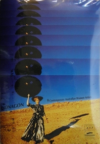 Women's Art Register
Education kit - Slides, Women's Art Register, Nonagon Slide Kit: 9 Contemporary Australian Women Artists, 1991
Produced by the VCE Consultative Committee: Women's Art Register in 1991 at a time when art courses in secondary schools had little material to use in relation to Australian women artists. An invaluable resource for secondary school teachers to broaden the scope of student knowledge about women artist's and thereby offer alternative role models for art students. This slide kit and booklet is a comprehensive, practical resource which provides a rare snapshot of women's art practices in the early 1990s. It is an excellent resource for research and teaching purposesKit containing 74 page booklet and 36 slides, activities, artist's comments and other source materials. Published in 1991 by the Women's Art Register. Artists include Elizabeth Gower, Sally Smart, Wendy Stavrianos, Pam Hallandal, tori de Mestre, Lyn Moore, Deborah Halpern, Tracey Moffat & Jill Orr. Cover image by Jill Orr, 'Walking on Planet Earth'elizabeth gower, sally smart, wendy stavrianos, pam hallandal, tori de mestre, lyn moore, deborah halpern, tracey moffat & jill orr. -
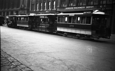 Melbourne Tram Museum
Negative, Wal Jack collection, 3/01/1939 12:00:00 AM
Negative of a photograph of two cable tram sets waiting to shunt at the Bourke St terminus, 3-1-1939. Has trailers 237 and 379 and 262 in the photo along with the Mail Exchange, and the Sunshine Machinery Depot. One of the cars has lady passengers on the grip car.trams, tramways, cable trams, bourke st, tram 237, tram 379, tram 262 -
University of Melbourne, Burnley Campus Archives
Negative - Colour negatives, Plant Materials, 1998
Photographs of plants. Negatives for Plant Materials I Degree/Diploma Weeks 1-11, 13 1998.plants, plant materials, 1998, diploma i -
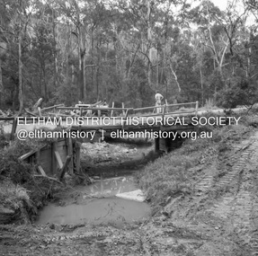 Eltham District Historical Society Inc
Negative - Photograph, J.A. McDonald, Heidelberg-Kinglake Road, Oct. 1959
Job 56M431 Contractors Wolf and Wood Yow Yow Creek Bridge Showing condition October 1959 Bypass back upstream side under constructionRecord of various Shire of Eltham infrastructure works undertaken during the period of 1952-1962 involving bridge and road reconstruction projects, sometimes with Eltham Shire Council Project Reference numbers quoted. It was during this period that a number of significant improvements were made to roads and new bridges constructed within the shire that remain in place as of present day (2022). In many situations, the photos provide a tangible visible record of infrastructure that existed throughout the early days of the Shire. The album was put together by or under the direction of the Shire Engineer, J.A. McDonald.infrastructure, shire of eltham, bridge construction, heidelberg-kinglake road, 1959-10, road construction, scan - 120 format 6x6 negative, yow yow creek -
Ringwood and District Historical Society
Legal record - Conditions of Sale (C.E.Carter), Ringwood East - Crown Allotments 35 & 36 - R. Davidson to Mrs J. A. E. Tudman. 1926
Particulars and Conditions of Sale of Property , from Robert Davidson to Jessie Tudman -
Ringwood and District Historical Society
Legal record - Conditions of Sale (C.E.Carter), Ringwood - Lot 11, Plan of Subdivision No 6753, M Somerville to M Perkins - 1929
Particulars and Conditions of Sale of Property , from Mary Somerville to Maria Perkins. -
Kew Historical Society Inc
Archive (Series) - Reno - St. John's Parade
Various PartiesReference, Research, InformationArranged by Secondary Values (value of records to users)‘Reno’ was a house demolished in 1977, designed by an architect simply known as ‘Cocking’, and was an example of the weatherboard cottage style. It was erected along St. John's Parade, Kew. Earliest records show the house existing as early as 1842, and passed hands until the City of Kew demolished it. The file includes: Correspondence between the Kew Historical Society and the City of Kew regarding the property’s preservation, photographs of the site before demolition, a newspaper article on the demolition, and a report detailing the site’s historical value.reno – kew (vic.), houses – kew (vic.)reno – kew (vic.), houses – kew (vic.) -
Moorabbin Air Museum
Plan (item) - Bristol Aeroplane 170 schematic drawings, Replacement of Side Frame Tube Engine Nacelle Structure
Bristol Aeroplane Company Ltd -
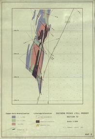 Federation University Historical Collection
Plan, Southern Prince Lyell Orebody 115 Sublevel, 1991, 01/1991
The planes of the orebody at South Prince Lyell, including felsic volcanics, silicified One, shale lenses and owen conglomerate.mount lyell, tasmania, southern prince lyell, orebody, volcanics, hale lenses, owen conglomerate, magnetite alteration