-
 Whitehorse Historical Society Inc.
Map, Yarra River, n.d
Copy of fold-out map 'Loddon 25' included in 'Lilydale', by Grace Aveling. Based on T.H. Nutt's original survey of the Yarra River, 1839.aveling, grace, nutt, t.h., yarra river -
Stawell Historical Society Inc
Archive - Laboratory Books, Textiles for Modern Living, Fifth Edition. E.P.G. Gohl and L.D. Vilensky
From Dye Laborataory AUNDE / Norwellan North Western Woolen Mills became Norwellan Textiles then AUNDEImage of Quilting on coverNorwellan Textiles Pty Ltdmanufacturing -
Moorabbin Air Museum
Archive (Item) - Box Baa 97 Boeing (Gaf / Asta) Collection
Description: - JINDIVIK DRAWINGS B3B-20-03/04 TO B3B-20-180 Level of Importance: National. Historical Details: DAP/GAF/ASTA constructed many overseas designs under licence in Australia (Beaufort, Beaufighter, Lincoln, Canberra and F18) however they also designed and constructed a number of significant local designs that were successful in oversea's markets includi -
Port Melbourne Historical & Preservation Society
Archive - Alan Mathews and family
The Mathews family have been in continuous ownership of 395 Howe Parade (was 8 Howe Parade until 1964 when addresses re-assigned), Port Melbourne from 1938 to the present (Sept 2019)Six folders of assorted documents relating to the life of Alan Mathews and his family. Collected items, paper notes, drawings from Alan's childhood. Undated letter from Flechett Bros P/L Publishing dept. Confirming enrolment in the "New Idea" leaguedomestic life, alan mathews -
Glenelg Shire Council Cultural Collection
Legal record - Memorandum and Articles of Association - Portland Butter Factory, Feb-12
Eight page booklet containing the Memorandum and Articles of Association of the Portland Butter Factory Limited. Pale blue cover, black print.portland butter factory, company records, legal records, dairy industry -
Port Melbourne Historical & Preservation Society
Plan - Port Melbourne Town Hall, Engineering Department, Town of Port Melbourne, 1915
Plan of new (1915) Town Hall, Port Melbourne Foundation Plan, ground floor plan; first floor planport melbourne town hall -
 University of Melbourne, Burnley Campus Archives
Plan, Orchard/Field Station, 1983 - 1992
(3) Used by Linda Hipwell for her Honours Thesis.Plans of the Orchard later known as the Field Station. (1) Copy, "Drawing: Orchard Site Plan." Each section labelled. (2)Tracing paper, 2 paper copies and 3 enlargements, "VCAH Burnley Field Station Plan," some printed labelling and some in pencil. 1992.(3) "VCAH Burnley Field Station Proposed Redevelopment," drawn by MG July 1992. (4) Tracing paper copy, Site Plan of Orchard by Alexander Metherell Pty. Ltd. Job No BHC/1 drawing No SP/2 Dec 1983. Scale 1:500. (5) Plan on tracing paper, includes Energy Education Centre. (6) Plan on tracing paper, includes Energy Education Centre. Scale 1:500. Also see B15.0352 Full Report. orchard, field station, linda hipwell, alexander metherell -
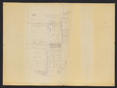
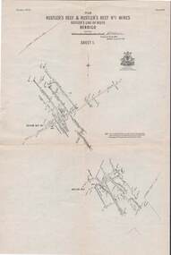 Bendigo Historical Society Inc.
Map - STRUGNELL COLLECTION: HUSTLER'S LINE OF REEFS, September 1913
Map, Hustler's Line of Reefs, Hustler's Reef & Hustler's Reef No.1 Mines, Plan view . Plate No. XV (15).Sheet 1 Bulletin No. 33. Included is the emblem of the Geological Survey of Victoria. Signed by H.A.Whitelaw Underground Survey Office, Bendigo, Septembe ,1913.Underground Survey Office, Bendigo.map, bendigo, hustler's reef & hustler's reef 1 -
Clunes Museum
Map
Photocopy of sections of Clunes gold mines, South Clunes United Co. 770 Feet, South No.4 Shaft, looking SouthNilmap of clunes mine, south clunes united co., no.4 shaft -
Bendigo Historical Society Inc.
Map - NEWSTEAD, 1/11/1939
Map: Town of Newstead, Parish of Strangways, County of Talbotmap, talbot, township, newstead, parish of strangways, county of talbot -
Port Melbourne Historical & Preservation Society
Archive - Alan Mathews and family, 1943
The Mathews family have been in continuous ownership of 395 Howe Parade (was 8 Howe Parade until 1964 when addresses re-assigned), Port Melbourne from 1938 to the present (Sept 2019)Six folders of assorted documents relating to the life of Alan Mathews and his family. Merit Certificate for elementary schools, Graham St, Port Melbourne. 12.11.1943education, alan mathews, james mathews -
 Eltham District Historical Society Inc
Negative - Photograph, J.A. McDonald, Heidelberg-Kinglake Road, Sep 1959
Job 56M430 Contractor Hone Just south of east abutment and access road to house showing block in table drain and wash towards Diamond CreekRecord of various Shire of Eltham infrastructure works undertaken during the period of 1952-1962 involving bridge and road reconstruction projects, sometimes with Eltham Shire Council Project Reference numbers quoted. It was during this period that a number of significant improvements were made to roads and new bridges constructed within the shire that remain in place as of present day (2022). In many situations, the photos provide a tangible visible record of infrastructure that existed throughout the early days of the Shire. The album was put together by or under the direction of the Shire Engineer, J.A. McDonald.infrastructure, shire of eltham, bridge construction, 1959-09, heidelberg-kinglake road, road construction -
 Eltham District Historical Society Inc
Negative - Photograph, Maroondah Aqueduct Trail east of Afton Street, Research, 1991
Roll of 35mm colour negative film, 9 strips Colour print 10 x 15 cmFuji HG 200 CA-1afton street, maroondah aqueduct, maroondah aqueduct trail, research (vic.) -
Bendigo Historical Society Inc.
Map - MANDURANG, Date unreadable
Map: Mandurang, County of Bendigo. Parish planmap, bendigo, parish plan, mandurang -
Glenelg Shire Council Cultural Collection
Negative - Negative - Portland, Victoria, Zilah Maschmedt, c. 1934
Negative for a black and white photograph. Photo taken from grass track near beach at Portland, looking across harbour. Baths, Ocean Pier, Railway Pier, Fishermen's Breakwater and Henty Beach. -
Stawell Historical Society Inc
Archive - Books & Papers, Stawell Rifle Club Records Minute books
Rifle Club existed from at least 1880's in Stawell 4271-1 Minute Book 7 May 1885 - 7 June 1899 4272-2 Minute Book 3 May 1907 - 11 October 1910 4272-3 Minute Book 12 July 1915 - 21 March 1921 4272-4 Minute Book 12 March 1917 - 21 January 1947 4272-5 Minute Book 20 May 1947 - 24 March 1960 4272-6 Correspondence Carbon Book 2 August 1957 26 Febuary 1978 4272-7 Minute Book 9 July 1960 - 15 March 1986 4272-8 Minute Book 7 April 1986 - 1 December 2001 4272-9 Minute Book 19 January 2002 - 9 June 2017Series of Ledgers 9 in all.sport -
Bendigo Historical Society Inc.
Map - JANIEMBER WEST : COUNTY OF BENDIGO, September 1955
Map. Janiember West, County of Bendigo. Loddon River, Janiember East, Powlett, Kinypanial, Jarklan. Welsh's Lagoon. By authority W.M. Houston, Government Printer, Melbourne. Drawn and reproduced at the Department of Lands and Survey, Melbourne, September 1955, Price 5/-. (number 66 in map cupboard 1)W.M. Houston, Government Printer, Melbourne.map, bendigo, janiember west -
Stawell Historical Society Inc
Map, Parish of Stawell, Sheet 4, 1958
Parish of Stawell, Sheet 4stawell -
Glenelg Shire Council Cultural Collection
Map - Map - West Sinclair Station, 1854
Map of West Sinclair Station. Hand drawn in black ink on khaki paper, glued to cardboard.west sinclair station -
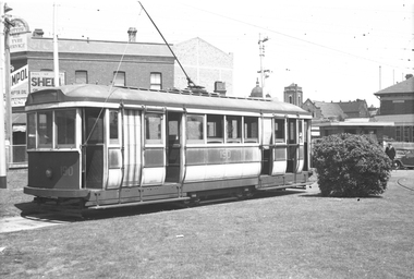 Melbourne Tram Museum
Negative, Wal Jack, c1950
Black and white negative, by Wal Jack, Q class 190 in the shunt at Camberwell Depot. Behind the tram is a building advertising Shell and Ampol. Tram in Chocolate and cream paint scheme and looks in poor condition. See Reg Item 3435i2 - Charles Craig and TAP343_190 by Jack Strangertrams, tramways, camberwell depot, q class, tram 190 -
Bendigo Historical Society Inc.
Map - LONG GULLY HISTORY GROUP COLLECTION: LONG GULLY
Copy of a map of Long Gully area with some street names, size of allotments, number, measurements, date and names.bendigo, history, long gully history group, the long gully history group - long gully, housing commission, housing act 1958, gazette -
Glenelg Shire Council Cultural Collection
Plan - Ship Plan / Mould, n.d
Wooden pattern for mould for boat fitting. Rod with U-shaped fitting attached to one end. Painted yellow -
Bendigo Historical Society Inc.
Map - YALLOOK, 25/02/1876
Map: Parish of Yallook, County of Bendigo. Parish plan. Map dated 25/02/1876.map, bendigo, parish plan, yallook -
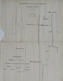 Federation University Historical Collection
Plan, Underground Survey of Mines, Ballaarat, not dated
Printed transverse section of the Speedwell Company.underground survey, speedwell company -
 Kew Historical Society Inc
Plan - Subdivision Plan, Maxwelton, Kew, 1920-1940
Pru Sanderson, in her groundbreaking ‘City of Kew Urban Conservation Study : Volume 2 - Development History’ (1988), summarised the periods of urban development and subdivisions of land in Kew. The periods that she identified included 1845-1880, 1880-1893, 1893-1921, 1921-1933, 1933-1943, and Post-War Development. These periods were selected as they represented periods of rapid growth or decline in urban development. An obvious starting point for Sanderson’s groupings involved population growth and the associated economic cycles. These cycles also highlighted urban expansion onto land that was predominantly rural, although in other cases it represented the decline and breakup of large estates. A number of the plans in the Kew Historical Society’s collection can also be found in other collections, such as those of the State Library of Victoria and the Boroondara Library Service. A number are however unique to the collection.The Kew Historical Society collection includes almost 100 subdivision plans pertaining to suburbs of the City of Melbourne. Most of these are of Kew, Kew East or Studley Park, although a smaller number are plans of Camberwell, Deepdene, Balwyn and Hawthorn. It is believed that the majority of the plans were gifted to the Society by persons connected with the real estate firm - J. R. Mathers and McMillan, 136 Cotham Road, Kew. The Plans in the collection are rarely in pristine form, being working plans on which the agent would write notes and record lots sold and the prices of these. The subdivision plans are historically significant examples of the growth of urban Melbourne from the beginning of the 20th Century up until the 1980s. A number of the plans are double-sided and often include a photograph on the reverse. A number of the latter are by noted photographers such as J.E. Barnes.The subdivision, ‘Maxwelton’, included four lots in East Kew, at the northwest corner of Burke Road and Cotham Road. Lot 3 is identified as the location of an existing house. The site of the subdivision equates to that parcel of land where a contemporary block of three storey apartments at 1245 Burke Road is now located.subdivision plans - kew, mazwelton subdivision, burke road -- kew (vic.), cotham road -- kew (vic.) -
 Kew Historical Society Inc
Plan, Melbourne and Metropolitan Board of Works, Borough of Kew : Detail Plan No.1580, 1904
The Melbourne and Metropolitan Board of Works (MMBW) plans were produced from the 1890s to the 1950s. They were crucial to the design and development of Melbourne's sewerage and drainage system. The plans, at a scale of 40 feet to 1 inch (1:480), provide a detailed historical record of Melbourne streetscapes and environmental features. Each plan covers one or two street blocks (roughly six streets), showing details of buildings, including garden layouts and ownership boundaries, and features such as laneways, drains, bridges, parks, municipal boundaries and other prominent landmarks as they existed at the time each plan was produced. (Source: State Library of Victoria)This plan forms part of a large group of MMBW plans and maps that was donated to the Society by the Mr Poulter, City Engineer of the City of Kew in 1989. Within this collection, thirty-five hand-coloured plans, backed with linen, are of statewide significance as they include annotations that provide details of construction materials used in buildings in the first decade of the 20th century as well as additional information about land ownership and usage. The copies in the Public Record Office Victoria and the State Library of Victoria are monochrome versions which do not denote building materials so that the maps in this collection are invaluable and unique tools for researchers and heritage consultants. A number of the plans are not held in the collection of the State Library of Victoria so they have the additional attribute of rarity.Original survey plan, issued by the MMBW to a contractor with responsibility for constructing sewers in the area identified on the plan within the Borough of Kew. The plan was at some stage hand-coloured, possibly by the contractor, but more likely by officers working in the Engineering Department of the Borough and later Town, then City of Kew. The hand-coloured sections of buildings on the plan were used to denote masonry or brick constructions (pink), weatherboard constructions (yellow), and public buildings (grey). The area represented in this detail plan has undergone significant change during the 20th century. The widening of High Street in the 1930s and 1950s involved the shops on the south side of High Street being demolished and later rebuilt to fit the widened street. Another significant loss was the mansion ‘Drayton’ fronting Wellington Street, owned at this stage by Susannah Fenton. Her family name would later to be given to Fenton Way, which was to be built over the grounds of the house following its demolition. The plan of the garden is particularly interesting, containing a batten dome fronting Wellington Street, an ornamental pond, a fountain and a brick and glass conservatory. The notes by the plumbing contractor on this plan are particularly detailed. Pink borders delineate the ownership of the varying parcels of land. Some of the better known owners listed include the real estate agent Cr. Henry de Castres Kellett (bt) and John Padbury, the funeral director. This particular plan provides a clear view of the configuration of the Kew Junction in 1903 and the commercial buildings that surrounded it.melbourne and metropolitan board of works, detail plans, maps - borough of kew, mmbw 1580, cartography -
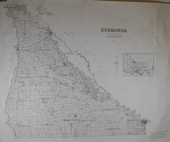 Bendigo Historical Society Inc.
Map - JACK FLYNN COLLECTION: GUNBOWER, 1935
Map: County of Gunbower, map sheet showing the whole of the County of Gunbower and all of the Parishes within.map, gunbower, county, gunbower -
Glen Eira Historical Society
Map - Coimbra, 5, Chaddesley Avenue, St Kilda East
A two page photocopy of a typed letter from Peter Upton, dated 10/04/1981, requesting information on the property Coimbra in Chattersley Lane (sic), St Kilda and detailing his family’s involvement in the property. He describes his memories of the house, its rooms, details of engraved glass, floral and decorative motifs and extensive garden. The file also includes a one page photocopy of a typed letter from the National Trust of Australia (Victoria) to the St Kilda Historical Society, dated 29/04/1981, concerning Peter Upton’s letter and requesting assistance in providing him with information about the relevant property as Coimbra does not appear on the Trust’s records. The letter includes a hand drawn map (62mm x 120mm) of the area in which the property is located. Also included is a one page typed letter from St Kilda Historical Society, dated 03/06/1981, to the Caulfield Historical Society, forwarding the letters received from Peter Upton and the Trust about Coimbra. The file also includes two handwritten versions of a two page letter, the final version dated 07/09/1981, from the Caulfield Historical Society to Peter Upton concerning his inquiry about Coimbra. It provides a brief list of occupiers of Coimbra from 1935 to 1974. Also included are two versions of a one page handwritten letter, the final version dated 07/09/1981, from the Caulfield Historical Society Historical to the St Kilda Historical Society thanking them for previous correspondence regarding Coimbra. The file also includes two handwritten versions of a one page letter, the final version dated 07/09/1981, to the National Trust of Australia (Victoria), from the Caulfield Historical Society, concerning Peter Upton’s inquiry about Combria. This letter is accompanied by a two page copy of the Society’s reply to Peter Upton. Also included is a one page typed letter of acknowledgement, dated 14/09/1981, from the National Trust of Australia (Victoria) to the Caulfield Historical Society.coimbra, upton henry e, saunders william g, causer archibald m, mansions, upton patricia henrietta, coimbra private hospital, connolly d, chaddesley avenue, chattersley lane, st kilda east, east st kilda -
Glenelg Shire Council Cultural Collection
Negative - Glass Plate Negative - Waterway, 1890-1910
Glass plate negative. Image shows a waterway, bush either side. Stumps of old fence in water. -
Kew Historical Society Inc
Archive (Sub-series) - Subject File, Kew Historical Society, DUMARESQ Family, 1958
Various partiesReference, Research, InformationSecondary Values (KHS Imposed Order)Subject file containing information on the Dumaresq family of Kew who were early settlers in Kew and in Tasmania. In Kew, the Dumaresqs built their house St Helliers (1888-), about which Margaret Dumaresq a member of the Society wrote a profile in 1959. In the file there are a number of newspaper articles/clippings including one noting the death of Miss Dumaresq who had been a Vice-President. In 1971, Miss Dumaresq presented a long talk on her family’s history, which was recorded and is now transcribed. Her discussion of her family’s past dates back to the Battle of Waterloo. What appear to be her handwritten notes are kept in the file. The file contains an album of 16 postcards of places and people at Melbourne University donated by FKM Dumaresq.dumaresq family - kew (vic), margaret dumaresq, fkm dumaresq, frances dumaresq, capt. edward dumaresq, edward alfred dumaresq, st helliers - kew (vic), postcards - melbourne universitydumaresq family - kew (vic), margaret dumaresq, fkm dumaresq, frances dumaresq, capt. edward dumaresq, edward alfred dumaresq, st helliers - kew (vic), postcards - melbourne university