-
 Kew Historical Society Inc
Archive (Sub-series) - Subject File, Kew, City of - Proclamation, 1921
Various partiesReference, Research, InformationKHS OrderKew was declared a City in 1921. The subject file contains two items relating to this proclamation: a photocopy of newspaper pictures showing Lord Stradbroke declaring Kew a City (Weekly Times, 19 March 1921 and a brochure produced in 1921 by Council to commemorate the event. kew - history, city of kew - proclamation, kew in 1921, local government - kew (vic.)kew - history, city of kew - proclamation, kew in 1921, local government - kew (vic.) -
 Eltham District Historical Society Inc
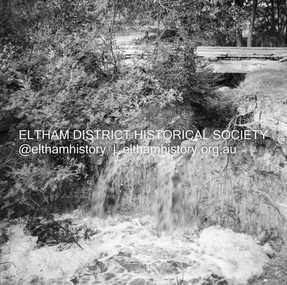
Negative - Photograph, J.A. McDonald, Dixons Creek, Sep. 1955
Record of various Shire of Eltham infrastructure works undertaken during the period of 1952-1962 involving bridge and road reconstruction projects, sometimes with Eltham Shire Council Project Reference numbers quoted. It was during this period that a number of significant improvements were made to roads and new bridges constructed within the shire that remain in place as of present day (2022). In many situations, the photos provide a tangible visible record of infrastructure that existed throughout the early days of the Shire. The album was put together by or under the direction of the Shire Engineer, J.A. McDonald.1955-09, dixons creek bridge, dixon's creek road, flood damage, floods, floodwater, infrastructure, shire of eltham -
 Wodonga & District Historical Society Inc
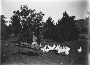
Negative - Haeusler Glass Negatives Collection - Child in a wheel barrow with chickens, c1910
The Wodonga Historical Society Haeusler Collection provides invaluable insight into life in late nineteenth and early twentieth century north east Victoria. The collection comprises manuscripts, personal artefacts used by the Haeusler family on their farm in Wodonga, and a set of glass negatives which offer a unique visual snapshot of the domestic and social lives of the Haeusler family and local Wodonga community. The Haeusler family migrated from Prussia (Germany) to South Australia in the 1840s and 1850s, before purchasing 100 acres of Crown Land made available under the Victorian Lands Act 1862 (also known as ‘Duffy’s Land Act’) in 1866 in what is now Wodonga West. The Haeusler family were one of several German families to migrate from South Australia to Wodonga in the 1860s. This digital image was produced from one of the glass negatives that form part of the collection, probably taken by Louis Haeusler (b.1887) with the photographic equipment in the Wodonga Historical Society Haeusler Collection. This item is unique and has well documented provenance and a known owner. It forms part of a significant and representative historical collection which reflects the local history of Wodonga. It contributes to our understanding of domestic and family life in early twentieth century Wodonga, as well as providing interpretative capacity for themes including local history and social history.Digital image created from the Haeusler Glass negative collection. A child sitting in a wheelbarrow with a basket of fruit. Chickens are feeding beside her. There is an orchard and a house in the background.wodonga pioneers, haeusler family, glass negatives, dry plate photography, wodonga children -
 Eltham District Historical Society Inc
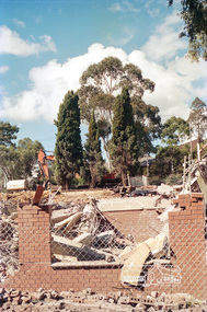
Negative - Photograph, Harry Gilham, Demolition of Eltham Shire Offices, 895 Main Road, Eltham, Aug. 1996
The Shire Offices opened in 1965 and were extended in 1971. The final Eltham Shire Council meeting was held in December 1994 before the forced amalgamations of municipal councils by the Kennett Government. The State-Government-appointed Commissioners (1994-1996) took the decision in July 1996 to demolish the Eltham Shire Offices. The demolition works started within 24 hours of the decision being made.Roll of 35mm colour negative film, 5 of 6 strips Associated colour printKodak Gold 100-5eltham shire office, demolition, shillinglaw trees -
 Eltham District Historical Society Inc
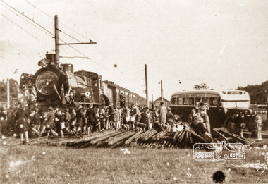
Negative - Photograph, Victorian Centenary Jubilee Steam Train 430, meeting with Eltham Bus Service, 1951
Roll of 35mm colour negative film, 4 stripsKodak Safety 5035eltham bus service, steam train, victorian centenary jubilee steam train 430 -
Bendigo Historical Society Inc.
Map - HAYANMI, 16/05/1879
Map: Hayanmi, County of Bendigo. Parish plan (number 294 in map cupboard 1)map, bendigo, parish plan, hayanmi -
 Eltham District Historical Society Inc
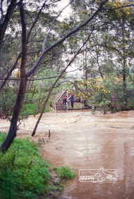
Negative - Photograph, Harry Gilham, Diamond Creek in flood, looking west towards Eltham High School (across submerged footbridge), c.Aug. 1996
This (submerged) footbridge has since been replaced by a higher-level bridge and the steps have been abolished.Roll of 35mm colour negative film, 5 of 6 stripsKodak Gold 100-5diamond creek, floods, dalton street, wingrove park trail, eltham high school -
 Bendigo Historical Society Inc.
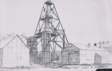
Negative - TOM PATULLO COLLECTION: MINE AND BUILDINGS
Negative print. Mine and Buildings. Poppet legs with cage support and gantry,three buildings at the side and front. R.Heddle.cottage, miners, mine and buildings., mine and buildings. -
 Melbourne Tram Museum
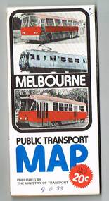
Map, Ministry of Transport, "Melbourne Transport Services Map - Tram, Train and Bus Services", 1976
Fold out map (27 sections 9 across x 3 deep), coloured of Melbourne's Tram and Bus routes, route numbers, rail lines, detailed for the central part of Melbourne and insert section for Frankston. On rear description of routes, private bus routes and map of Melbourne metro lines. Has contact details for bookings and lost property etc. Priced 20c Has a bus, silver train and a Z class tram on the cover. On bottom of outside cover, "No. 5 1976"On front cover in ink "5" in top right hand corner and "4 G 33 " along bottom edge.trams, tramways, melbourne, map, tram & bus services, railways, mmtb, minister for transport -
 Wodonga & District Historical Society Inc
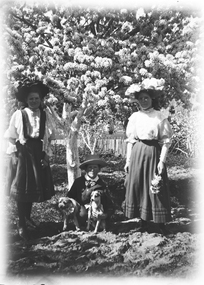
Negative - Haeusler Glass Negatives Collection - Mrs. Walter McFarlane with two children and a dog, c1910
The Wodonga Historical Society Haeusler Collection provides invaluable insight into life in late nineteenth and early twentieth century north east Victoria. The collection comprises manuscripts, personal artefacts used by the Haeusler family on their farm in Wodonga, and a set of glass negatives which offer a unique visual snapshot of the domestic and social lives of the Haeusler family and local Wodonga community. The Haeusler family migrated from Prussia (Germany) to South Australia in the 1840s and 1850s, before purchasing 100 acres of Crown Land made available under the Victorian Lands Act 1862 (also known as ‘Duffy’s Land Act’) in 1866 in what is now Wodonga West. The Haeusler family were one of several German families to migrate from South Australia to Wodonga in the 1860s. This digital image was produced from one of the glass negatives that form part of the collection, probably taken by Louis Haeusler (b.1887) with the photographic equipment in the Wodonga Historical Society Haeusler Collection. This item is unique and has well documented provenance and a known owner. It forms part of a significant and representative historical collection which reflects the local history of Wodonga. It contributes to our understanding of domestic and family life in early twentieth century Wodonga, as well as providing interpretative capacity for themes including local history and social history.Digital image created from the Haeusler Glass negative collection. An image of Mrs. Walter McFarlane on the right with two children, standing under a tree in full bloom. The boy in the centre is holding two dogs.wodonga pioneers, haeusler family, glass negatives, dry plate photography, mcfarlane family -
Glenelg Shire Council Cultural Collection
Negative - Glass Plate Negative - Blowholes Bridgewater Bay, 1890-1910
Stereoscopic glass plate negative. Images shows a group of people standing on rocks below cliff, watching waves hitting rocks throwing up large spray (? Blowholes). -
Bendigo Historical Society Inc.
Map - BENDIGO GOLDFIELD MAP 1913, 1913
DVD. Bendigo Goldfield Map 1913. -
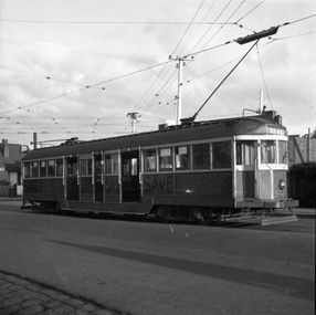 Melbourne Tram Museum
Negative, Wal Larsen, 1949
Black and white negative, of SW2 565 (St Kilda Beach) on the Moreland Road stub at Brunswick/Coburg. Has the tracks to Brunswick Depot in the background. On the side of the tram is a sign "Save to help control prices" Photo not in Wal Jack Melbourne album. Neg was in a Bright Methodist Church offering envelope - stored with negative file - has 1949 in pencil on the envelope. Wal Larsen was a Bright resident. Note on the background to the sign: Norman Abjorensen wrote in The Canberra Times about the election of Menzies in 1949 - see https://www.canberratimes.com.au/story/6532529/the-election-which-shaped-australia-for-decades/ (Accessed 9-6-2021): Not known how the sign was sponsored. "The uncertainty was magnified by a range of post-war concerns and expectations that the expansionary 1949 budget brought into sharp focus. The nation was still war-weary, tired of austerity and impatient with rationing and controls; people wanted to spend their accumulated savings on the new household goods starting to appear in stores, and the taxation burden was resented. Further, rising inflation was a problem, with the Consumer Price Index rising by more than 10 per cent in 1949. It was little wonder Menzies' pledges to end rationing and "put value back in the pound" fell on such eagerly receptive ears."trams, tramways, w2 class, moreland road, tram 556 -
 Bacchus Marsh & District Historical Society
Map, Lerderderg District Proposed Irrigation and Water Supply Trust (A). Plan showing boundaries of Trust District
The 1886 Irrigation Act in Victoria introduced the first legislation in Australia designed to enable the creation of a detailed scheme for agricultural irrigation. Part of the legislation saw the use of government funds for local irrigation projects. These local projects were managed by local irrigation trusts. The Lerderderg Irrigation and Water Supply Trust] was formed in 1890. This map depicts the proposed area of the Trust.Printed paper map of the proposed Lerderderg District Irrigation and Water Supply. Plan showing boundaries of Trust District. The Lerderderg District lies within the Parishes of Korkuperrumul and Merrimu in the County of Bourke. At the top of the map above its title is the letter 'A; in capital lettering. Scale: 40 Chains = 1 inch.irrigation, water supply, lerderderg irrigation and water supply trust -
Kew Historical Society Inc
Archive (Series) - Pioneers of Kew
Various PartiesReference, Research, InformationArranged by Secondary Values (value of records to users)A collection of the first residents within Kew during the colonial period of Australia. Many owned businesses and played an important role in the early development of the area. The file includes: A newspaper article, letters addressed to and from the Kew Historical Society regarding research on individuals, a list of Kew residents sourced from the Australian Dictionary of Biography, and research done on some of the early pioneers of Kew circa. 1960. This research covers: James F. Roberts, Alfred Hurlstone, A.C. Hurlstone, John Watson, Frederick Derham MLA, Stanley T., Frederick Dunn, Jonathan Pettit, John Pinniger, and Frederick Stowe.pioneers – kew (vic.), james f. roberts – kew (vic.), alfred hurlstone – kew (vic.), john watson – kew (vic.), frederick derham – kew (vic.), frederick dunn – kew (vic.), jonathan pettit – kew (vic.), john pinniger – kew (vic.), frederick stowe – kew (vic.)pioneers – kew (vic.), james f. roberts – kew (vic.), alfred hurlstone – kew (vic.), john watson – kew (vic.), frederick derham – kew (vic.), frederick dunn – kew (vic.), jonathan pettit – kew (vic.), john pinniger – kew (vic.), frederick stowe – kew (vic.) -
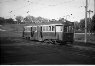 Ballarat Tramway Museum
Negative, Wal Jack, c1950
Negative and Digital images of the Wal Jack Geelong Negative file of Geelong bogie 32 at the Beach terminus, c1950. See Reg Item 7814 for a similar photograph, most likely taken at the same time. Tram 32 has the destination of "West". Shows the double track layout at this location. trams, tramways, geelong, beach, tram 32 -
Stawell Historical Society Inc
Archive - Ledger, Stawell Flour Mill (Frayne Street)
FRayne Street: Stawell Flour Mill 1934 - 1940Portrait- Covers seperated taped on book with blue tape front and end pages blue and white marbled.Ledger - The Specialty Press Pty Ltd Account Books logo. 26/02/34 Accounts listed in alphabetical section -
Bendigo Historical Society Inc.
Map - NOLAN, 5/03/1888
Map: Nolan, County of Bendigo. Parish plan (number 284 in map cupboard 1)map, bendigo, parish plan, nolan -
Glenelg Shire Council Cultural Collection
Negative - Negative - Whalers Bluff, Portland Victoria, ZILLAH MASCHMEDT, PHOTOGRAPHER, c. 1934
Negative for a black and white photograph. View from Whaler's Bluff, looking out over Portland Harbour. Nun's Beach, Ocean Pier, Railway Pier, Fishermen's Breakwater, Battery Point. -
 Eltham District Historical Society Inc
Negative - Photograph, Coghill & Haughton, On the banks of the Plenty, c.1924
Negative copy and associated print of detail from original Sales Brochure: Plenty Township Estate and Bryn Teg Hill's Estate, Coghill & Haughton, Melbourne (c.1924)Roll of 35mm Black and White negative film, 3 strips, (1 of 14 frames) Print 10 x 15 cmFilm - Agfa Ortho 25bridge, bryn teg, bryn teg hill's estate, coghill & haughton, heidelberg golf club hotel, houses, lower plenty, lower plenty bridge, lower plenty road, main road, mrs m thomas, plenty river, plenty township estate, real estate agent, sales brochure -
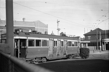 Melbourne Tram Museum
Negative, Wal Jack, 1/09/1941 12:00:00 AM
Black and white negative, by Wal Jack, of E class 44 in the parking siding at Camberwell Depot. Has the destination of Special and route number B. Photo dated 1-9-1941, in the Wal Jack album.trams, tramways, e class, camberwell depot, tram 44 -
Bendigo Historical Society Inc.
Map - GOORNONG, Revised 5/06/1926
Map: Town of Goornong, Parish of Goornong, County of Bendigo ( number 153 in Map Cupboard 1)map, bendigo, township, goornong, county of bendigo -
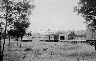 Eltham District Historical Society Inc
Negative - Photograph, Eltham Railway Station, c.1912
Viewed from the western side looking north east. A Tait rail car and Guard's van are parked at the platform.This photo forms part of a collection of photographs gathered by the Shire of Eltham for their centenary project book,"Pioneers and Painters: 100 years of the Shire of Eltham" by Alan Marshall (1971). The collection of over 500 images is held in partnership between Eltham District Historical Society and Yarra Plenty Regional Library (Eltham Library) and is now formally known as the 'The Shire of Eltham Pioneers Photograph Collection.' It is significant in being the first community sourced collection representing the places and people of the Shire's first one hundred years.Digital image 4 x 5 inch B&W Neg Print B&Wsepp, shire of eltham pioneers photograph collection, eltham, railway station -
Glenelg Shire Council Cultural Collection
Negative - Glass Plate Negative - Rural setting, 1890-1910
Glass plate negative. Image shows a group of eight women and one man posing in rural setting. -
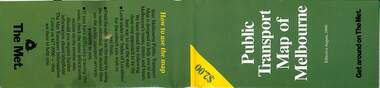 Melbourne Tram Museum
Map, The Met, Public Transport Map of Melbourne - Get around on The Met, 8/1990
Melbourne transport map - dated August 1990 - includes a map of the ticket zones, and The Met contact details and notes where tickets can be obtained fromYields information about Melbourne public transport services in August 1990Fold out map (36 sections 9 across x 4 deep), "Public Transport Map of Melbourne", coloured of Melbourne's Tram and Bus routes, route numbers, rail lines, detailed for the central part of Melbourne and the outer Metropolitan services.tramways, melbourne, tram services, bus services, railways, maps, zones -
Bendigo Historical Society Inc.
Map - TANDARRA : COUNTY OF BENDIGO, 14-3-24
Map. Tandarra, County of Bendigo, Talambe, Yallook, Neilborough, Whirrakee, Kamarooka. Myers Creek, Tandarra Estate. Photo-Lithographed at the Department of Lands and Survey, Melbourne by W.J. Butson, 14-3-24. Price 1/-. By authority Albert J. Mullett, Government Printer, Melbourne. (number 25 in map cupboard 1)Albert J. Mullett, Government Printer, Melbourne.map, bendigo, tandarra -
Stawell Historical Society Inc
Archive - Book, Stawell Shire, Registration Of Residence Sites 28-7-1931 - 20-6-1934, 1931
Residence Area Miners Right used by Stawell ShireLarge Brown Covered Leather Ledger with Label on front coverStawell Ararat Mining District Registration Book 12P local government, miners right -
Bendigo Historical Society Inc.
Map - HUSTLER'S REEF MINE - TRANSVERSE SECTION OF THE HUSTLER'S REEF MINE
Transverse Section of the Hustler's Reef Mine on the Hustler's Line of Reefs. Bulletin No 33, Plate No XVIII. Shows cross-cuts and their depth, different types of stone and geological features encountered. Drawing of poppet legs at the surface and Sill of Shaft 756.39 ft above Sea Level. Reference Table shows key to the different stone and geographical features encountered. Geographical Survey of Victoria. Signed by H A Whitelaw, Underground Survey Office, Bendigo, September 1913. Thompson's Reef is also mentioned on the map. This item has not been scanned or photographed.mining, parish map, hustler's reef mine, transverse section of the hustler's reef mine, geological survey of victoria, h a whitelaw, underground survey office bendigo, thompson's reef. -
 Eltham District Historical Society Inc
Negative - Photograph, J.A. McDonald, Inspection of storm damaged Abraham house at Kangaroo Ground, c. May 1962
Showing the effect of a wind storm that destroyed the house circa May 1962.. The Abraham family owned land near the Aqueduct and east of Nicholas Lane at Kangaroo Ground (based on photos, at or near 40 Nicholas Lane).Record of various Shire of Eltham infrastructure works undertaken during the period of 1952-1962 involving bridge and road reconstruction projects, sometimes with Eltham Shire Council Project Reference numbers quoted. It was during this period that a number of significant improvements were made to roads and new bridges constructed within the shire that remain in place as of present day (2022). In many situations, the photos provide a tangible visible record of infrastructure that existed throughout the early days of the Shire. The album was put together by or under the direction of the Shire Engineer, J.A. McDonald.1962-05, abraham house, kangaroo ground, nicholas lane, property damage, storm damage, building surveyor, george e. newton -
Bendigo Historical Society Inc.
Map - HUSTLER'S REEF & HUSTLER'S REEF NO 1 MINES - PLAN OF THE HUSTLER'S REEF & HUSTLER'S REEF NO 1 MINES
Plan of the Hustler's Reef & Hustler's Reef No 1 Mines on the Hustler's Line of Reefs Bulletin No 33, Plate No XV. Plan shows the two mines with depth of levels, geological features and levels in relation to the shaft. Geological Survey of Victoria emblem and signed by H A Whitelaw, Underground Survey Office Bendigo, September 1913. Note - The Lease Boundaries shown on this plan are only in their approximate relative positions to Nos 13, Intermediate and 14 Levels of the Hustler's Reef No 1 workings, and Nos 15, 16 and 17 Levels of the Hustler's Reef workings.mining, parish map, hustler's reef & hustler's reef no 1 mines, plan of the hustler's reef & hustler's reef no 1 mines, geological survey of victoria, underground survey office bendigo, h a whitelaw, hustler's line of reefs