-
 Bendigo Military Museum
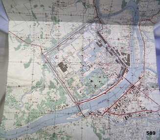
Map - MAP HUE VIETNAM, C.1960’s
The city of Hue is in South Vietnam. The map was used by a member of the AATTV during the Tet Offensive in Thau Thien province. Map brought home from Vietnam by Murray Stanley Metherall. Refer 590.2.Colour printed map of Hue Citadel on paper. Aerial view of land, river and building outlines.hue, vietnam, tet -
 Moorabbin Air Museum
Plan (item) - Bristol Aeroplane 170 schematic drawings, Access Door- Bottom Skin- Rear Spar Centre Plane
Bristol Aeroplane Company Ltd -
 Wodonga & District Historical Society Inc
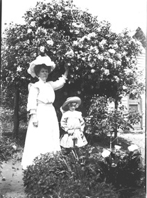
Negative - Haeusler Glass Negatives Collection - Woman and young girl under a flowering bush, c1910
The Wodonga Historical Society Haeusler Collection provides invaluable insight into life in late nineteenth and early twentieth century north east Victoria. The collection comprises manuscripts, personal artefacts used by the Haeusler family on their farm in Wodonga, and a set of glass negatives which offer a unique visual snapshot of the domestic and social lives of the Haeusler family and local Wodonga community. The Haeusler family migrated from Prussia (Germany) to South Australia in the 1840s and 1850s, before purchasing 100 acres of Crown Land made available under the Victorian Lands Act 1862 (also known as ‘Duffy’s Land Act’) in 1866 in what is now Wodonga West. The Haeusler family were one of several German families to migrate from South Australia to Wodonga in the 1860s. This digital image was produced from one of the glass negatives that form part of the collection, probably taken by Louis Haeusler (b.1887) with the photographic equipment in the Wodonga Historical Society Haeusler Collection. This item is unique and has well documented provenance and a known owner. It forms part of a significant and representative historical collection which reflects the local history of Wodonga. It contributes to our understanding of domestic and family life in early twentieth century Wodonga, as well as providing interpretative capacity for themes including local history and social history.Digital image created from the Haeusler Glass negative collection. It depicts an unidentified woman and child standing beneath a flowering bush. A house is partially visible in the background.wodonga pioneers, haeusler family, glass negatives, dry plate photography -
Bendigo Historical Society Inc.
Map - HUSTLER'S REEF & HUSTLER'S REEF NO 1 MINES - PLAN OF THE HUSTLER'S REEF & HUSTLER'S REEF NO 1 MINES
Plan of the Hustler's Reef & Hustler's Reef No 1 Mines on the Hustler's Line of Reefs, Bendigo Bulletin No 33, Plate No XVI. Plan shows the two shafts and the levels in relation to it. No 9 Level 896 feet 9 inches connecting No 10 Level at 867 feet 2 inches. Plan shows depth of levels and geographical features. Signed by H A Whitelaw, Underground Survey Office, Bendigo. Geographical Survey of Victoria emblem.mining, parish map, hustler's reef & hustler's reef no 1 mines, hustler's line of reefs, plan of the hustler's reef & hustler's reef no 1 mines, h a whitelaw, underground survey office bendigo, geographical survey of victoria, mining -
 Stawell Historical Society Inc
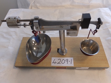
Archive, Two sets of Scales (Pharmacy) Pleasant Creek Training Centre
stawell -
 Melbourne Tram Museum
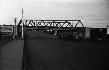
Negative, Wal Jack collection, 1940's
Black and white negative by Wal Jack of W4 670 (Maribyrnong River, route 54), passing under the rail over bridge for the Coburg railway line in Racecourse Road, Flemington. Tram about to cross the Moonee Ponds Creek bridge. Tram number identified on print in album. Photo undated, c1940.trams, tramways, racecourse road, w4 class, route 54, tram 670 -
Moorabbin Air Museum
Journal (item) - Assorted Aviation Magazines - see Notes
-
Bendigo Historical Society Inc.
Map - NEWSTEAD, 1/11/1939
Map: Town of Newstead, Parish of Strangways, County of Talbotmap, talbot, township, newstead, parish of strangways, county of talbot -
Whitehorse Historical Society Inc.
Map, City of Whitehorse, 1/03/1995 12:00:00 AM
Map showing streets of the City of Whitehorse from Mullum Mullum Creek to the north to Highbury Road and Warrigal Road in the west, to Heatherdale Road in the east.Map showing streets of the City of Whitehorse from Mullum Mullum Creek to the north to Highbury Road and Warrigal Road in the west, to Heatherdale Road in the east. Prep. by Richard Meloni. Scale 1:15,000Map showing streets of the City of Whitehorse from Mullum Mullum Creek to the north to Highbury Road and Warrigal Road in the west, to Heatherdale Road in the east. city of whitehorse, mullum mullum creek -
Bendigo Historical Society Inc.
Map - WELLSFORD : COUNTY OF BENDIGO, 15-12-41
Map. Wellsford, County of Bendigo, Bagshot, Ellesmere, Axedale, Strathfieldsaye, Huntly, Sandhurst. Drawn and reproduced at the Dept. of Lands and Survey, Melbourne.15-12 41. Price 2/-. By authority H.E. Daw, Government Printer, Melbourne. (number 20 in map cupboard 1)H.E. Daw, Government Printer,Melbourne.map, bendigo, wellsford -
Clunes Museum
Archive - COMPACT DISC, GEORGE ROSE
Stereo-graph images taken by George RoseDisc contains images of the Postcard Era "P series" postcards listed numerically and alphabetically in town orderNilgeorge rose, postcards, stereograph -
 Eltham District Historical Society Inc
Negative - Photograph, Henley Bridge, c.1928
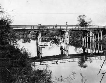
Situated on the Yarra River, 5.5 kms south of Christmas Hills on private property. This timber trestle bridge is said to have been built some time after 1907 by Melbourne master-builder, David Mitchell (the father of Dame Nellie Melba), to connect his two "Henley Farm" properties with Lilydale. In earlier days, when the McPhersons owned the property, their children used a punt to cross the river to attend Yering Primary School. This private bridge is best viewed from the end of Wendy Way. - Source: Christmas Hills Past and Present, Yarra Glen & District Historical Society, 2004.This photo forms part of a collection of photographs gathered by the Shire of Eltham for their centenary project book,"Pioneers and Painters: 100 years of the Shire of Eltham" by Alan Marshall (1971). The collection of over 500 images is held in partnership between Eltham District Historical Society and Yarra Plenty Regional Library (Eltham Library) and is now formally known as the 'The Shire of Eltham Pioneers Photograph Collection.' It is significant in being the first community sourced collection representing the places and people of the Shire's first one hundred years.Digital image 4 x 5 inch black and white negative 9 x 12.5 cm printshire of eltham pioneers photograph collection, warrandyte, henley bridge, reflection -
 Halls Gap & Grampians Historical Society
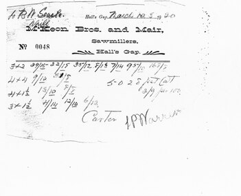
Financial record - Invoice photocopy
A copy of an invoice dated 5 March 1920 from a Halls Gap sawmilling company to B N Searle of Nhill for various items of sawn timber. Either the carter was LP Warren or the invoice is signed by LP Warren and has Carter written at the bottom for some reason.A photocopy of an invoice (No. 0048) dated "March no(?) 5 1920" from McKeon Bros. and Mair, Sawmillers Hall's Gap to B. N. Searle, Nhill.timber industries, sawmilling -
 Bendigo Historical Society Inc.
Negative - Glass Slides, About 1900 to 1930
Five Glass Slides- single piece of glass with emulsion on one side. Unknown Subjects, one couple, two toddlers, and a young woman.history, bendigo -
 Melbourne Tram Museum
Negative, Wal Jack collection, 1921
Black and White copy Photograph of L 106 soon after commissioning. Has the M&MTB on the side of the trams and four doorways as ordered by the PMTT. Prior to fitting the standard destination boxes and removing one of the doorways. Elsternwick Post Office in the background. See Reg Item 5012 for information on the photo provided by Keith Kings. Photo is in the PRO H collection.trams, tramways, pmtt, l class, new tramcars, mmtb, tram 106 -
Glenelg Shire Council Cultural Collection
Negative - Negative - Gardens and Salt Creek Portland, Victoria, c. 1934
Negative for a black and white photograph. Image shows Portland, Victoria Gardens on right, Salt Creek, dirt road and footpath in foreground. -
 Eltham District Historical Society Inc
Negative - Photograph, Shire of Eltham, Eltham Shire Council Staff. Eltham Shire Office, 895 Main Road, Eltham, Jan. 1980
eltham, 895 main road, eltham shire council, eltham shire office, staff members -
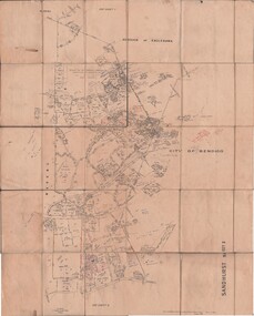 Bendigo Historical Society Inc.
Map - JACK FLYNN COLLECTION: SANDHURST SHEET 2, January 1947
Map: Parish of Sandhurst Sheet 2, County of Bendigo. Parish plan.By Authority J. J. Gourley, Government Printer, Melbourne. Drawn and Reproduced at the Dept, of Lands and Survey, Melbourne, Victoria.map, bendigo, parish plan, sandhurst sheet 2 -
Moorabbin Air Museum
Plan (Item) - BAC 1-11 111 Drawings
-
 Kew Historical Society Inc
Map, MMBW, MMBW Plan No.65 Kew & Heidelberg, 1900-1910
The Melbourne and Metropolitan Board of Works (MMBW) was established by an act of the Victorian Parliament in 1890 to prepare for and to implement a sewerage and water reticulation system across what was then inner Melbourne, its surrounding and middle distance suburbs, including Kew. The MMBW was disbanded in 1991.The map collection of the Kew Historical Society has at its core the historic maps assembled and originally stored in the City Engineer's Department of the City of Kew. These include maps in a number of scales. The vast majority of maps were produced by the MMBW in the first two decades of the twentieth century, and are solid working maps, backed by linen for durability. These maps are historically significant to Kew, the City of Boroondara and to the history of the development of state utilities in Victoria. A number of the Kew maps have additional details added by former municipal officers, including the levels reached by various floods. As these were working documents, information was added to them long after the period of their initial production and distribution.Early map of part of the Borough of Kew, created in the first decade of the twentieth century, at a scale 160 ft to 1 inch. The map covers what was then the south central part of Kew, bordered on its north by Malmsbury Street, in the west by Florence Avenue, in the south by Barkers Road, and in the east by Princess Street. The map shows the extent of urban development by that time, prominent institutions and the outlines of built structures in the municipality. Contour lines were added in ink to the map at a later stage.MELBOURNE AND METROPOLITAN BOARD OF WORKS / PLAN NO. 65 / KEW & HEIDELBERGmelbourne & metropolitan board of works, mmbw maps, mmbw plans, borough of kew, cartography -
 Robin Boyd Foundation
Journal, Peter Bellew, Art in Australia, Jun, Jul, Aug 1942
Includes 2 articles by Walter Bunning - "Aesthetics and War" p.71, "Rachel Forster Hospital" p.85. Walter Bunning was a prominent Australian architect and urban planner - a contemporary of Robin Boyd.walter bunning, rachel forster hospital, world war 2, walsh st library -
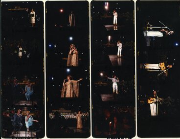 Vision Australia
Negative - Image, Henk Rem, Performers on stage at the 1979 Carols by Candlelight performance
Brian Naylor and (possibly MP Jeannette Patrick, Paul Meenie and Linda George, Margaret Nesbitt, Kirri Adams and Franciscus Henri at the 1979 Carols by Candlelight.Colour transparencies taken at Carols by Candlelightcarols by candlelight, brian naylor, paul meenie, linda george, margaret nisbett, kirri adams, franciscus henri -
Kew Historical Society Inc
Archive (Sub-series) - Subject File, Businesses (Kew), 1958
Various partiesReference, Research, InformationSecondary Values (KHS Imposed Order)Subject file containing many newspaper articles/clippings, mostly modern. The file does include correspondence from organisations and individuals relating to businesses and organisations (eg Masonic Hall). The file contains an undated flyer for businesses including: Payne’s Bon Marche (138-144 Bourke Street)), the Prospect Hill Hotel, the Hosiery Depot, Tolver Silvers (118 High Street), and sundry invoices trade marks etc. commerce - kew -- (vic.), economy -- kew (vic.)commerce - kew -- (vic.), economy -- kew (vic.) -
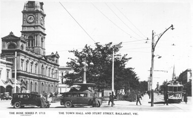 Ballarat Tramway Museum
Negative - Copy, Rose Stereograph Co, "The Town Hall and Sturt Street Ballarat Vic", - rear
Yields information about Ballarat 's trams in the 1930's and three street scene at the City Centre with the Town Hall in the background. Shows nature of the area with street lights and parked motor vehicles and a sign on the tram regarding prohibition and a vote on the banning of the sale of alcohol.Copy negative of a black and white photograph from Ray Pearson Collection, taken by Dave Macartney in 1975c of the intersection of Sturt and Lydiard St during the late 1920s. From the Rose series P1713, photograph of a postcard. Shows tram with a "Vote No" banner - about a local vote on prohibition in Ballarat? See Reg Item 5117 for another version and 8979 for the actual postcard. Image from the Ray Pearson album used to replace previous image 30/5/2020. Ray Pearson identified this as No. 6 in his album.trams, tramways, sturt st, prohibition, town hall -
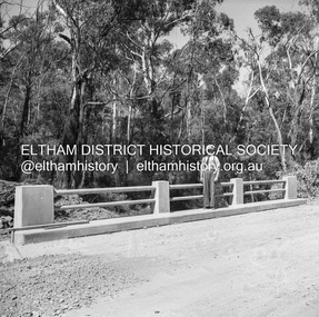 Eltham District Historical Society Inc
Negative - Photograph, J.A. McDonald, Heidelberg-Kinglake Road, Mar. 1960
Job 56M431 Bridge handrails March 1960 Line Foreman Dan Boyd (PMG) Contractor W.E. WolfRecord of various Shire of Eltham infrastructure works undertaken during the period of 1952-1962 involving bridge and road reconstruction projects, sometimes with Eltham Shire Council Project Reference numbers quoted. It was during this period that a number of significant improvements were made to roads and new bridges constructed within the shire that remain in place as of present day (2022). In many situations, the photos provide a tangible visible record of infrastructure that existed throughout the early days of the Shire. The album was put together by or under the direction of the Shire Engineer, J.A. McDonald.infrastructure, 1960-03, bridge construction, cherry tree road, heidelberg-kinglake road, road construction, shire of eltham -
University of Melbourne, Burnley Campus Archives
Plan, Construction Detail - Paving; Construction Detail - Mower strip, 1980 - 1990
Tracing paper designs (x 2) landscape design, paving, mower strip -
Moorabbin Air Museum
Plan (item) - Bristol Aeroplane 170 schematic drawings, Assembly of Lever Complete
Bristol Aeroplane Company Ltd -
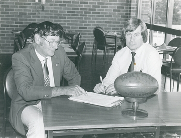 Ringwood and District Historical Society
Archive - Parent Record, East Ringwood Football Club - Archive Collection (Parent Record)
Parent Record for Archive collection of photographs and documents relating to East Ringwood Football Club -
Bendigo Historical Society Inc.
Map - CORNELLA : COUNTY OF BENDIGO, 18-3-08
Map. Cornella, County of Bendigo, County of Rodney, Colbinabbin, Gobarup, Redcastle, Toolleen, Cornella Creek, Kangaroo Creek. Photo-Lithographed at the Department of Lands and Survey, Melbourne by T.F. McGauran. 18-3-08. Price 1/-. (number 122 in map cupboard 1)T.F. McGauranmap, bendigo, cornella -
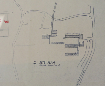 Federation University Historical Collection
Plan, Ballarat Institute of Advanced Education Electrical Engineering Buillding Plans, 1972-1973, 1972-1973
Ballarat Institute of Advanced Education is a predecessor instituion of Federation University Australia. Five plans for the Mount Helen Campus E Building. ballarat institute of advanced education, electical engineering, e building, ewan jones, mt helen campus, architectural drawing