-
 Kew Historical Society Inc
Archive (Series) - Plaques [Kew]
Various PartiesReference, Research, InformationArranged by Secondary Values (value of records to users)In 2005, the City of Boroondara introduced the Plaques Policy, which was to establish guidelines of the use and installation of plaques in the area. The file includes: Letters between the City of Boroondara and the Kew Historical Society regarding the proposed legislation, and a draft of the legislation.plaques – kew (vic.), memorials – kew (vic.)plaques – kew (vic.), memorials – kew (vic.) -
Stawell Historical Society Inc
Archive - Laboratory Books, Worsted Preparing and Spinning Vol1 & Vol2. J M Bennett
From Dye Laborataory AUNDE / Norwellan North Western Woolen Mills became Norwellan Textiles then AUNDETwo Small Dark Blue BooksJ.M. Bennett manufacturing -
 Bendigo Historical Society Inc.
Map - JACK FLYNN COLLECTION: GOORNONG, August 1953
Map: Township of Goornong, Parish of Goornong, County of Bendigo. Parish plan.By Authority W.M. Houston. Government Printer. Drawn and Reproduced at the Dept., of Lands and Survey, Melbourne, Victoria. August 1953map, bendigo, township, goornong -
Whittlesea Historical Society Inc.
Archive - Box, Whittlesea Historical Society - WHS - Maps. 1
Archive Box with lid - Whittlesea Historical Society - WHS - Maps. 1. Contents: 1. Green binder Folder, labelled "Maps", with inventory of contents. Contents: 1. Map Parish of Keelbundora, 11 June 1956, large sheet 2. Map Parish of Keelbundora, undated, one sheet 3. Map Parish of Keelbundora, 1946 4. Map Parish of Keelbundora 5. Map Parish of Keelbundora, 5 Jun 1953 6. Map Parish of Keelbundora, blue sheet 7. Morang - Portions 11-14, A4 page 8. Golden Wattle Estate, 23 Feb 1962, A3 sheet 9. Range View Estate, A4 sheet 10. Golden Wattle Ranges Estate, 22 Feb 1962, A4 sheet 11. Golden Wattle Estate Hurstbridge, A3 12. Shire of Whittlesea including Epping Station, Nov 86, A3 13. Whittlesea, including Epping Road, A3 14. Station Estate Thomastown including Thomastown Railway Station 15. Station Estate Thomastown including Thomastown Railway Station 16. Thomastown Estate, date prior to decimal currency, A3 poster 17. Certificate of Title - Thomastown Station subdivision, 18 Oct 1926, Transfer of Lands Act Titles 18. Plan of Subdivison of Stages 1 & 2 Thomastown 19. Poster - Auction Sale Thomastown, 27 Oct 1923 20. Thomastown, 24 Nov 1907. Grey coloured Archive Box containing mapsWhittlesea Historical Society - WHS - Maps. Box 1.map, archive, achival box -
 Ringwood and District Historical Society
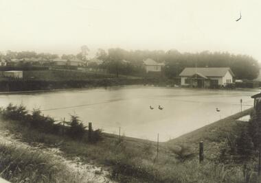
Archive - Parent Record, Ringwood Bowling Club / City of Ringwood Bowls Club Archive Collection of Photographs and Documents 1929 - current (Parent Record)
1929 saw the establishment of the Ringwood Bowls Club initially located on the land now occupied by the Eastland Shopping Centre. It moved to its current location in Loughnan Road, Ringwood in 1997.This is the parent record for the large archives collection of the Ringwood Bowls Club formerly the City of Ringwood Bowls Club), consisting of various photos and documents from the club's beginning in 1929. Individual items fall in the VC Reference Number range 30000 - 31999 and where possible are grouped by year. city of ringwood bowls club, ringwood bowling club, ringwood bowls club, lawn bowls, bowling -
Whitehorse Historical Society Inc.
Map, Shires of Boroondara, Nunawading, C1856
Photocopy of part of very early map covering parts of Boroondara and Nunawading.Photocopy of part of very early map covering parts of Boroondara and Nunawading. Marks old tracks on lines of Whitehorse and Canterbury Roads.Photocopy of part of very early map covering parts of Boroondara and Nunawading.maps, shire of nunawading, shire of boroondara, barkers track, deep creek, nunawading -
 Warrnambool and District Historical Society Inc.
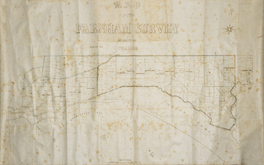
Map - Farnham Survey, 1850s
This is a map of the Farnham Special Survey. In 1843 William Rutledge purchased this Special Survey of 5,120 acres and named it Farnham. This Survey extended from Tower Hill to the Merri River at Dennington. The map appears to date from the 1850s This early map is of considerable significance as it shows details of the Farnham Special Survey. William Rutledge and his survey are important influences in the development of Warrnambool and district with the establishment of settlements at Killarney, Yangery and Tower Hill.A hand drawn map on waxed paper in brown, black and blue ink. It shows Armstrong's Bay, sea, Crown Land , the names of properties and some roads. It includes a compass direction diagram.farnham special survey -
 Stawell Historical Society Inc
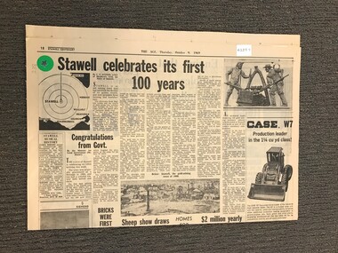
Archive - Newspaper Suppliment, Stawell Celebrates its First 100 Years 1969, 09/10/1969
Newspaper Pages from the AGE Thursday October 9,1969 Pages 17-20Stawell Centenarystawell, centenary -
Bendigo Historical Society Inc.
Map - TARNAGULLA SHEET 1, Examined 25/08/1926
Map: Tarnagulla Sheet 1, Counties of Gladstone and Bendigo. Parish plan (number 304 in map cupboard 1)map, gladstone, parish plan, tarnagulla -
Kew Historical Society Inc
Archive (Sub-series) - Subject File, Kew Historical Society, HARRISON, Henry Colden Anthill, 1958
Various partiesReference, Research, InformationSecondary Values (KHS Imposed Order)TBCkew historical society - archives, australian rules football - history - victoria, henry harrisonkew historical society - archives, australian rules football - history - victoria, henry harrison -
 Melbourne Tram Museum
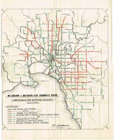
Map, Melbourne & Metropolitan Tramways Board (MMTB), "Proposals for General Scheme", 27/08/1923 12:00:00 AM
Map - drawing with a line back, titled "Melbourne and Metropolitan Tramways Board Proposals for General Scheme". Shows the proposed tram lines submitted to Parliament for the report into the General Scheme. Printed by Sands & McDougall Pty Ltd. Signed by J. P Strickland dated 27-8-1923. See Reg item 3374.2 for a better copy.trams, tramways, mmtb, general scheme, tramways, development, parliament, brighton, railways, map -
Port Melbourne Historical & Preservation Society
Archive - Port 'n' South Living and Learning Centre, 1985 - 1995
The centre was one of several community groups established in the mid 1980's. After 1998 when the Baptist Church decided to discontinue the relationship, co-ordinator Julie Allen donated the minutes, brochures, photos and other records to the society.From archive box containing the archives of the Port 'n' South Living and Learning Centre located at the Ross St Baptist church, 1985 to 1998. Also includes item 1207 (various files listed on separate attachment) Refer also to items 1084 and 819 and 1207. .06 - set of A5 term programs approx 1986 to 'Last chance term" Oct-Dec 1987. Four terms to a year. Many are duplicated . 4 to 8 pageseducation, community, education - adult, societies clubs unions and other organisations, religion - baptist church, julie allen -
Beechworth Cemetery Trust
Map - Beechworth Cemetery reproduction of original map - On site in Rotunda, Beechworth Cemetery
Reproduction map displaying all grave sites in Beechworth Public Cemetery. Rotunda, fountain, nursery, memorial wall, pioneer sectionmap displays the plan of grave sitesLaminated Photocopy of original cemetery map with additional information hand-written on the map. All graves at the cemetery set out in denominational sections with hand-written information on additional graves added to sections in Roman Catholic A & C, Church of England A-F, Presbyterian A-C, Methodist/Uniting B and Wesleyan A. Multidenominational hand-written note on Jews section with Trust Minutes 4.7.'83 written next to this addition. Additions hand-drawn of fountain, memorial wall, nursery and pioneer cemetery.rotunda, fountain, nursery, memorial wall, pioneer section, graves, chinese section, un-numbered grave sites, cemetery -
Bendigo Historical Society Inc.
Archive - MCCOLL, RANKIN AND STANISTREET COLLECTION: CENTRAL NELL GWYNNE, 19
Object. Blue metal box with hinged lid. Knob handle on the lid. The inside of the box is divided into three compartments.Central Nell Gynne painted on the lid.mining, business, mining box 6, mccoll, rankin & stanistreet, central nell gwynne, gold mining, boxes -
Whitehorse Historical Society Inc.
Map, Schwerkolt property, 1/10/2003 12:00:00 AM
A reworking by Ted Arrowsmith of Arthur Schwerkolt's plan of the Schwerkolt property as it was in the 1930's.A reworking by Ted Arrowsmith of Arthur Schwerkolt's plan of the Schwerkolt property as it was in the 1930's.A reworking by Ted Arrowsmith of Arthur Schwerkolt's plan of the Schwerkolt property as it was in the 1930's.schwerkolt cottage, schwerkolt, arthur -
 Melbourne Legacy
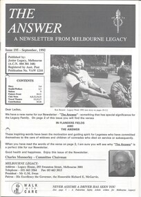
Journal - Newsletter, The Answer. A newsletter from Melbourne Legacy, 1992
The September 1992 edition of the Melbourne Legacy newsletter was the first to be called 'The Answer'. The name comes from the verse that guides the work of Legacy - 'In Flanders Field' and 'The Answer' (see page 2). This is an example of Melbourne Legacy Club newsletters, covering the activities of Melbourne Legacy Widows' Club. It includes photos of events. Information includes a notice from the Chairman of the Widows' Committee, dates of meetings, possible day trips and theatre outings, and cruises. The ladies were welcome to attend monthly meetings, card afternoons, indoor bowls competitions, outings and tours, plus the annual fete and Christmas concert. The first edition of the newsletter was in 1960, previously there had been a quarterly magazine but the distribution was limited, they changed to a 4 page newsletter format to reach more of the widows. This edition had become 20 pages. Various pages of interest have been added to show different news items. Other editions haven't been scanned.Brings to life the activities provided for the widows and the work of Melbourne Legacy.Black and white printed newsletter from September 1992, Issue 195, the first copy called The Answer.newsletter, answer, activities -
Glen Eira Historical Society
Map - CAPLES PLACE SUBDIVISION
This file contains a copy of a map of the CAPLES PLACE SUBDIVISION, undated and author unknown. The map provides the dimensions of roads and allotments in the area, including also handwritten notes from the original document and others written directly onto the copy.land subdivisions, documents, maps, glen eira, caples place, caples place subdivision, land surveys, orrong road, mulgrave road, prahran grove, somerset road, prahran grove, prahran grove, east walk, land allotments, town planning, garden road -
Stawell Historical Society Inc
Archive - Books & Papers, Ken Hyslop, Campbells Bridge Back to 1991, 1991
Associated with Back to Campbells Bridge and writing of Campbells bridge development and Social History 1861 - 1991. By Ken HyslopRecords relating to Campbells Bridge back to 1991. Plus Back to sign in bookVisitors Booksocial history -
Bendigo Historical Society Inc.
Map - WOODSTOCK : COUNTY OF BENDIGO, 26-9-17
Map. Woodstock, County of Bendigo, Derby, Leichardt, Marong, Shelbourne, Laanecoorie, Tarnagulla. L.5512. Photo-Lithographed at the Depatment of Lands and Survey, Melbourne, by W.J. Butson, 26-9-17. Price 1/-. By authority A.J. Mullett, Government Printer, Melbourne. (number 19 in map cupboard 1)A.J. Mullett, Government Printer.map, bendigo, woodstock -
Ringwood and District Historical Society
Legal record - Conditions of Sale (C.E.Carter), Ringwood - Lot 11, Plan of Subdivision No 6753, M Somerville to M Perkins - 1929
Particulars and Conditions of Sale of Property , from Mary Somerville to Maria Perkins. -
Bendigo Historical Society Inc.
Map - YARRABERB : COUNTY OF BENDIGO, 23-2-15
Map. Yarraberb, County of Bendigo, Salisbury, Yallook, Neilborough, Nerring, Leichardt, Bridgewater. L5373. Photographed at the Department of Lands and Survey, Melbourne by W.J. Butson 23-2-15. Price 1/-.By authority: Albert J. Mullett, Government Printer, Melbourne. (number 16 in map cupboard 1)By authority Albert J. Mullett, Government Printer.map, bendigo, agricultural lands -
Stawell Historical Society Inc
Map, Western Mining Corp / Stawell Joint Venture, Cross Section of Shafts. Long Section Newington - Three Jacks Looking West, August 1991
WMC/SJV Cross Section Western Mining Corporation Limited Stawell Joint Venturemining, gold, map -
 Melbourne Tram Museum
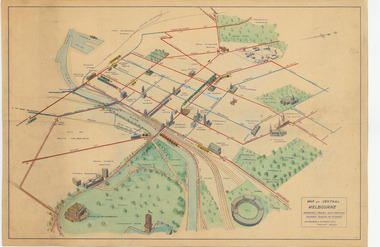
Map, Melbourne & Metropolitan Tramways Board (MMTB), "Map of Central Melbourne", c1952
Map - dyeline print then hand coloured, titled "Map of Central Melbourne", subtitled "Showing tram and bus routes, railways, places of interest:. Includes railway yards. gardens, trams routes shown in direction in some places. Has initials WKGP in bottom right hand corner. Map c1952, after the Latrobe St lines opened but before Bourke St lines opened. Note: 1 - The Hanna St or South Melbourne depot is shown south of City Road, not south of Sturt Street as it should have been. 2 - route 78 shown terminating at Batman Ave is incorrect, ran from Victoria and Church Sts. Original document scanned as a high res tiff file, approx. 60MB, see large files directory - htd3736-large.tiftrams, tramways, mmtb, map, melbourne, tram routes, south melbourne depot, hanna st depot, latrobe st, la trobe st -
National Vietnam Veterans Museum (NVVM)
Journal, Victorian historical journal
royal historical society of victoria - periodicals -
Stawell Historical Society Inc
Archive - CD/DVD, Holford Wettenhall, Family photographs including Carrs Plains Aboriginals, sheep, floods, horses, snow, 2006
stawell -
Stawell Historical Society Inc
Map, Special Surveys, District of Ararat, 1968
Special Surveys, District of Araratstawell -
Stawell Historical Society Inc
Archive - Certificate, Stawell Biarri Group for Geneology Inc
Biarri is now in Historical society due to ageing insufficent members. Black Framed Certificate of Licencecertificate of Licence - Family research -
Stawell Historical Society Inc
Map, Parish of Stawell, Sheet 3, 1958
Parish of Stawell, Sheet 3stawell -
Stawell Historical Society Inc
Archive - CD/DVD, Glenorchy Images Mitchell Bakery 1970, 1940's Glenorchy, Jim Mitchell, Archie McCallums Horses, Glenorchy School, Football Club, Scouts, Tennis Club Members, Roman Catholic Picnic 1899, Swinton, Wimmera Hotel, Bayllie Blacksmith, Presbyterian Church
stawell, plowing -
Port Melbourne Historical & Preservation Society
Legal record - Photocopy, Will, Jean Guillaume Liardet, 1700 - 2000
From red binder of family history of Caroline and Willbraham Liardet consisting of photocopies of various photos and documents, family trees, etc.donated by Philippa Gamlin, granddaughter of Leonora. .03 - Translation of the will (dated 20.05.1815) of Jean Guillaume Liardet.Each leaf is numberedliardet family, phillippa gamlin, ynys grecian