Showing 93463 items
matching documentation
-
 Charlton Golden Grains Museum Inc
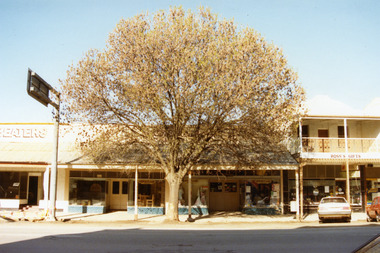
Photograph, High St shops c. 1987
Tippett's Clothing store established in c.1923. Ross's Gifts formerly Ike Richards hairdresser and gift shop was built as Procter's Butchery in 1880.Colour photograph of Tippett's Clothing and Furniture shop, and Ross's Gifts and Plants. Large tree in front of Tippett's. Tippett's shop has two entrances, both with double doors. Small part of the Panel Beaters showing on LH side of photo. A white car and a red car parked in front of Ross's.tippett's furniture and clothing store, ross's gifts and plants, ike richards hairdresser, procter's butchery -
 Eltham District Historical Society Inc
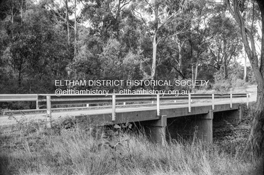
Negative - Photograph, Russell Yeoman, Oxley Bridge, Henley Road, Kangaroo Ground, c.1970
Roll of 35mm black and white negative film, 4 of 7 strips and corresponding B&W printIlford HP4bridge, bridges, watsons creek, kangaroo ground, bend of islands, henley road -
 Surrey Hills Historical Society Collection
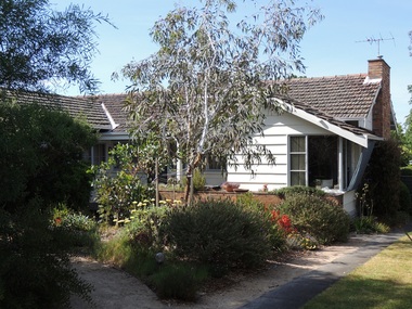
Photograph - 11 Boronia Street, Surrey Hills, The Street Where You Live Project
Photos documenting this address as part of a photographic series undertaken by volunteer photographers during 2013 and 2014 for The Street Where You Live Project. This was organised through the Surrey Hills Neighbourhood Centre and covered the postcode 3127 in the cities of Boroondara and Whitehorse.These photos provide a snapshot of real estate in the suburbs of Mont Albert and Surrey Hills during a period of rapid change with many properties on large blocks demolished to create higher density residential development or renewal of single dwellings. At particular risk were properties not covered by heritage overlays, especially interwar housing and post 1950's housing. -
 Glenelg Shire Council Cultural Collection
Photograph - Photograph - Portland Library, Victoria, 10/10/1998
Coloured photo. Portland Library, book sale, several large tables, loaded with booksFront: '98 10 19' -
 Surrey Hills Historical Society Collection
Photograph - 40 Kenmare Street, Mont Albert, The Street Where You Live Project
Photos documenting this address as part of a photographic series undertaken by volunteer photographers during 2013 and 2014 for The Street Where You Live Project. This was organised through the Surrey Hills Neighbourhood Centre and covered the postcode 3127 in the cities of Boroondara and Whitehorse.These photos provide a snapshot of real estate in the suburbs of Mont Albert and Surrey Hills during a period of rapid change with many properties on large blocks demolished to create higher density residential development or renewal of single dwellings. At particular risk were properties not covered by heritage overlays, especially interwar housing and post 1950's housing. -
 Bendigo Historical Society Inc.
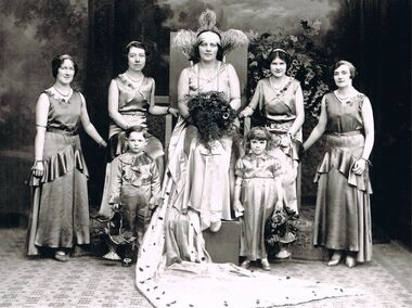
Photograph - PATRICIA COLES (NEE MCLEAN) COLLECTION: BENDIGO EASTER PARADE QUEEN COMPETITION 1929
Photograph. The Patricia Coles (nee McLean) Collection. Bendigo Easter Parade Queen Competition 1929. Copy of a black and white photograph of four women, one seated on a central chair, with flowers, and two small children. A boy and a girl. On the reverse the Queen, seated, is identified as Gwen McPherson (Mr McPherson, her father, was a senior policeman in Golden Square). The small girl, front right, is named as June McLean, daughter of Nellie and Tom McLean, United Kingdom Hotel, Golden Square. [Note: Peter MOLONEY, Gwen's son emailed [email protected] 13/10/2014 after the photo appeared in the Bendigo Advertiser, 'The Way We Were’ - 'Hi, please have a look at the attached photo. My name is Peter Moloney, Gwen McPherson’s son; my grandfather was a policeman at Golden Square from about 1935 to 1945. My mother was born in 1920. Given all the information above and also the fact that the 'Queen' in the photo does not look like my mother, who would have been 9 years old in 1929, I am afraid the detail on the photo is incorrect. Hope this information is of some use to you. Peter Moloney.']bendigo, entertainment, easter parade queen competition, bendigo easter fair. bendigo easter parade queen compettion. mclean family of golden square. united kingdom hotel. -
 Melbourne Legacy
Photograph, Annual Demonstration
A photo of a junior legatee in a costume from an annual demonstration. Throughout the year Melbourne Legacy provided classes for Junior Legatees such as dancing, gymnastics and Eurythmics. The Demonstration was an annual event to showcase their skills. Melbourne Legacy conducted Annual Demonstrations / Parades from 1928 through to the 1980's, usually held at Melbourne Town Hall or Olympic Pool Stadium. The beautiful costumes were made by members of the Junior Legacy Mothers' Club and the Melbourne Legacy Wives' Association. A record of a costume used at the Annual Demonstrations. Also that Legacy provided classes for junior legatees and the skills learned were displayed in the Annual Demonstration.Black and white photo of a junior legatee displaying her costume for an Annual Demonstration.annual demonstration, junior legatee, costume -
Malmsbury Historical Society
Photograph (Item), Daffodil Display, Malmsbury ca 1989
Buildings - Town Hall People - "Hedley, B; Jones, Mr J; Monti, Mrs" -
 Surrey Hills Historical Society Collection
Photograph - 113 Middlesex Road, Surrey Hills, The Street Where You Live Project
Photos documenting this address as part of a photographic series undertaken by volunteer photographers during 2013 and 2014 for The Street Where You Live Project. This was organised through the Surrey Hills Neighbourhood Centre and covered the postcode 3127 in the cities of Boroondara and Whitehorse.These photos provide a snapshot of real estate in the suburbs of Mont Albert and Surrey Hills during a period of rapid change with many properties on large blocks demolished to create higher density residential development or renewal of single dwellings. At particular risk were properties not covered by heritage overlays, in particular interwar housing and post 1950's housing. -
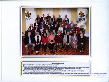 Federation University Historical Collection
Photograph, Spielvogel Photographics, Ballarat Teachers' College Class of 1948 60 Year Reunion, 02/05/1988
Ballarat Teachers' College is a predecessor institution of Federation University Australia.A photograph in a cover of the Ballarat Teachers' College Class of 1948 60 Year Reunion held in 2008.ballarat teachers' college, reunion, class of 1948, aurita rowland, aurita perry, anniversary, robert clark, ray boatman, gordon guley, heather mckenzie, heather greening, lois macinnes, marion barber, rita perry, elga mannic, mavis wollin, kathleen richmond, jean guley, jean forrest, joan caotes, joan coard, bill birthisel, maisie cunningham, lorna lyon -
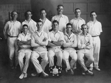 Stawell Historical Society Inc
Photograph, "Rovers" Cricket Team c1930
Cricket - Rovers Team c1930stawell sport -
Port Melbourne Historical & Preservation Society
Photograph - Lagoon Confectioners employees, 1960
This was shot at former premises in Albert Road, and copied for a 'Farewell display' shown at 1999 Port Festival, Mayor's Day and Senior Cits Week events. Two of the women were still working with Lagoon after 40 years (ref. item 963.02)Lasercopy from black and white print loaned by Lagoon Confectioners: five women employees photographed in 1960. Left to right, Lil SAYERS, Margaret LANE, Mella and Pat MORIER, Phyl CAMILLERI. industry - food, lil sayers, margaret lane, mella morier, lagoon confectionery pty ltd, business and traders - confectioners, phyl spotkeiff nee camilleri, pat aquilina nee morier -
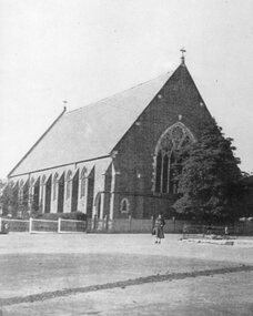 Stawell Historical Society Inc
Photograph, Holy Trinity Church Stawell c1920’s
Holy Trinity Church Stawell c1920’sstawell -
Kew Historical Society Inc
Journal, The Kewriosity Sheet Vol.4 No.1 : August 1982
Community effort for St Paul's [School for the Blind] / p1. Annual elections for the City of Kew - North Ward [J. Ormando, P.R. Palmer]; College Ward [P.M. Tunney, P.N.V. Wallinga]; Studley Park Ward [R.E.H. Saunders, M.J. Slattery] / p1. Scrabble / p1. School Holiday Program / p1. R.A.A.V. [Rheumatism and Arthritis Association of Victoria] / p1. Early Planning for Retirement Group / p1. Calling all pioneers!!! [Kew Historical Society; Allen family] / p1. Hyde Park Fellowship [Hyde Park Uniting Church] / p2. What's doing in Kew for August / p2&3. Starlight Theatre Company presents "Gi Gi" / p3. Kew's library grows [Large print books] / p3. Remember boneseed blitz [Studley Park] / p3. "Drop in" [Kew Uniting Church] / p3. Kew Garden Club / p3. Kew Elder Citizen's Club / p3. In the Streets of Kew [transport history] / Barbara Giles p4. Play Centre [Toddler/Kindy Gym Play Centre] / p4. Native Plant Group / p4.The Kewriosity Sheet (1979-83) was first published in the City of Kew (Victoria) in June 1979 as a two-sided 'community newssheet'. It aimed to: 'share news about Kew happenings and Kew people, and to exchange ideas about living in Kew'. Later issues gradually evolved into a 4-page, quarto sized publication. The Kewriosity Sheet was superseded by the Kew Council publication 'Kewriosity' (1983-1994).non-fictionCommunity effort for St Paul's [School for the Blind] / p1. Annual elections for the City of Kew - North Ward [J. Ormando, P.R. Palmer]; College Ward [P.M. Tunney, P.N.V. Wallinga]; Studley Park Ward [R.E.H. Saunders, M.J. Slattery] / p1. Scrabble / p1. School Holiday Program / p1. R.A.A.V. [Rheumatism and Arthritis Association of Victoria] / p1. Early Planning for Retirement Group / p1. Calling all pioneers!!! [Kew Historical Society; Allen family] / p1. Hyde Park Fellowship [Hyde Park Uniting Church] / p2. What's doing in Kew for August / p2&3. Starlight Theatre Company presents "Gi Gi" / p3. Kew's library grows [Large print books] / p3. Remember boneseed blitz [Studley Park] / p3. "Drop in" [Kew Uniting Church] / p3. Kew Garden Club / p3. Kew Elder Citizen's Club / p3. In the Streets of Kew [transport history] / Barbara Giles p4. Play Centre [Toddler/Kindy Gym Play Centre] / p4. Native Plant Group / p4. community publications --- kew (vic.), the kewriosity sheet, newsletters - kew (vic.) -
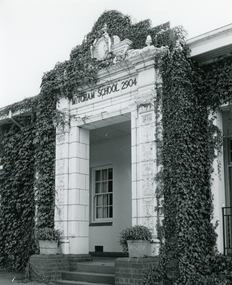 Whitehorse Historical Society Inc.
Photograph, Mitcham State School, C1970
Black and white photo of front entrance to Mitcham State School 2904.Mitcham Road Mitcham. C1970. Visitors only entrance - pupils to rear of buildingmitcham state school no 2904, visitors only entrance - pupils to rear of building -
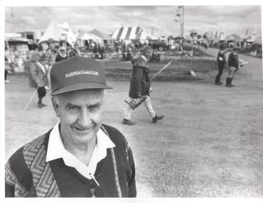 Bendigo Historical Society Inc.
Photograph - PHOTOGRAPH. ELMORE, 1993
Photograph. Elmore. Man at front left is unnamed. Background, may relate to the Elmore Field days. (Wild guess only). -
 Eltham District Historical Society Inc
Photograph - Aerial Photograph, Landata, Eltham; Crown Allotment 15, Section 5, Parish of Nillumbik (Stokes Orchard Estate), Mar. 1987
Centred on present day Diosma Rd, Stokes Pl, Nyora Rd and Eucalyptus Rd Historic Aerial Imagery Source: Landata.vic.gov.au Aerial Photo Details: Project No :1716 Project : WESTERN PORT FORESHORES Run : 15 Frame : 108 Date : 03/1987 Film Type : B/W Camera : RC10 Flying Height : 5600 Scale : 10000 Film Number : 4102 GDA2020 : 37°43'00"S, 145°10'13"E MGA2020 : 338725, 5824036 (55) Melways : 22 D5 (ed. 42)719 (55) Melways : 22 D4 (ed. 42) A History of the Development of Crown Allotment 15, Section 5, Parish of Nillumbik – Stokes Orchard Crown Allotment 15, Section 5, Parish of Nillumbik (CA15) is a square allotment of 158 acres or approximately a quarter of a square mile. It lies just beyond the eastern end of Pitt Street, south of Nyora Road to the northern end of Eucalyptus Road and extends east from Eucalyptus Road to Reynolds Road. The topography of CA15 is generally steep, sloping up to a hill near the centre of the land, the ridgeline passing through the properties along the southern side of Diosma Road. Eucalyptus Road is a straight north-south road with its northern end at the north west corner of CA15. Until the end of the 1970s this road was an un-named Government Road and was largely not open to traffic. With residential development in the 1970s the road was constructed, and the council allocated the name obviously in recognition of the predominant species of the local bushland. CA15 was purchased from the Crown by George D’Arley Boursiquot, a prominent Melbourne printer, on 28th October 1852. On November 23, 1922, former Member for Gippsland and Melbourne Real Estate Agent, Hubert Patrick Keogh purchased the allotment then sold it March 13, 1925, to local farmer, Robert David Taylor, a former Shire of Eltham Councillor (1911-1920) and Shire President (1919). Taylor had extensive land holdings stretching west towards Bible Street and Main Road. The Taylor home was situated at the top of the hill in Bible Street at present day 82 Bible Street. At the time of Taylor’s purchase in 1925, CA15 was subdivided into 48 lots that could be described as small rural properties or large residential lots. A typical lot size was one hectare or 2.5 acres. The subdivision created two roads, Nyora Road, and Diosma Road, each following an irregular alignment between Eucalyptus and Reynolds Roads. However, the lots were not sold off separately nor were the roads constructed. The land effectively remained as one parcel for many further years. Robert David Taylor died November 30, 1934, and probate was granted to his son of the same name, Robert David Taylor of Bible Street, Salesman and William McLelland Vance Taylor of 73 Emmeline Street, Northcote, Clerk, with the transfer of the land into their names on July 8, 1935. Frank Stokes worked as a qualified accountant at Kennons leather factory in Burnley, while living at 1 Thomas Street, Mitcham. He suffered from migraines and wanted to return to working the land (he had previously worked on farms and orchards since coming to Australia from England in 1926, both in WA and Vic.). He first travelled to the district by train in July 1942 to find land with the intention to establish an orchard. By chance he met Arthur Bird of Bird Orchard (bounded by Pitt Street, Eucalyptus Road, and Wattle Grove) and they got talking over their common interest. Arthur put Frank up for the night and pointed out the land, 158 acres- part of the Taylor Estate- £900, Crown Allotment 15, Section 5, Parish of Nillumbik (CA15) somewhat diagonally opposite Bird Orchard. Stokes applied through the Riverina Agency to purchase the land who in turn applied for permission from Canberra to sell as there was a new government regulation introduced during the Second World War banning land sales except for immediate production. Stokes obtained a loan on his Mitcham house of £600 @ 5% and paid £450 deposit with quarterly payments of £15 spread over 5 years. Stokes was assisted and advised by Arthur Bird who farmed the neighbouring orchard. In early 1943 Stokes took possession and would catch the train out to Eltham on Fridays after work and began building a hut on the corner of Nyora Road and the Government Road (Eucalyptus Road) for shelter and to lock up tools. He established an orchard on the central western part of the land through the centre of which ran a natural waterway (part of the present-day linear park) and was able to pay a neighbour (Hawkins) to help with clearing and fencing 25 acres, and with a horse and single furrowed plough, planted approximately 2,500 fruit trees - cherries, peaches, plums, almonds, pears, apricots and lemons as well as a few apples and oranges; a massive task. Aerial photographs from the 1940s through to the 1990s clearly show the orchard with most of the larger CA15 site remaining as natural bushland. A huge problem was hares and rabbits eating all the new buds off the tiny trees. As well as laying poison he painted the trees with a mixture of cow manure and lime, often working by moonlight. Procurement of wire and wire netting was difficult because of the war but after much effort he obtained a permit from the Agricultural Department for supplies in March 1944. In February 1945 Stokes applied for a permit to build a “packing shed” as no house building was allowed. It was to be 33 feet x 21 feet and cost £312. It was constructed mostly from second-hand materials, which were hard to obtain, especially iron for roofing. Stokes finished work at Kennons on October 31, 1945, and in March 1946 he sold the family home at Mitcham for £1,230 plus £170 for furniture. On May 15, 1946, title to the CA15 property was issued to Frank Howard Alfred Stokes, Orchardist and Gladys Ethel Stokes, Married Woman, both of Pitt Street, Eltham. The family of five then moved into the very unfinished “packing shed” at Eltham, which was a struggle to weatherproof. Eventually rooms were divided off and lined with hessian bags and whitewashed. Their income was firewood (cut and sold), selling rockery stones and cut Sweet Bursaria. (It was discovered during the 1940s that Sweet Bursaria contained the sunscreen compound Aesculin. The RAAF utilised this compound from Sweet Bursaria during WW2 for pilots and gunners.) The orchard’s first fruit sale was a half-case of Le Vanq peaches in December 1947 for the price of 8 shillings. In 1956 plans for house were drawn and Glen Iris bricks purchased (1956 Olympic Rings variant). The building of the house commenced in 1957 - 12 feet of original packing shed was removed – and was completed in 1959. Water was connected from newly built pressure storage on the property at the end of 1959 and the electricity connection for the first time at 3pm on April 29, 1960. The house remains to present day (somewhat modified) at 1 Nyora Road, home to Nyora Studio Gallery. On occasions, spare remnants of the 1956 bricks have been known to be unearthed in gardens on the estate as they were utilised by Frank Stokes to fill in rabbit holes. On May 26, 1950, a parcel of land was compulsorily acquired by the Melbourne and Metropolitan Board of Works on the hilltop to establish an easement for a high-level service reservoir to augment Eltham’s water supply. The project also included pipe tracks for the necessary water mains. The reservoir has now been superseded by higher level water tanks east of Reynolds Road and its former site is now a public reserve. On November 27, 1964, the State Electricity Commission served notice to compulsorily acquire a further parcel through the eastern part of the land for a major electricity transmission line that augmented supply from the La Trobe Valley to Melbourne. The easement was registered February 11, 1966. The easement was widened July 18, 1969 for a second transmission line to be constructed. In 1971 Melbourne Metropolitan Planning Scheme amendments adopted Nyora Road as the boundary between a residential zone to the north and a rural zone to the south. This determined the future development of the land. In the mid-1970s the Shire of Eltham divided the orchard into numerous rate-able parcel lots, the 48 lots having been established in 1925 and the subsequent rates assessment proved unsustainable for Stokes. He commenced selling lots outside the boundary of the orchard, north of Diosma and South of Nyora. However shortly later the land between Nyora and Diosma Roads and west of the electricity easement was sold and subdivided into residential lots, a housing development by Macquarie Builders and marketed as the Stokes Orchard Estate. New streets were created, and most were named after trees, although one, Stokes Place, commemorates the former owners. The development was undertaken in two stages; Stage 1 (1975) encompassing Scarlet Ash Court, Ironbark Close and Peppermint Grove bounded by Nyora and Eucalyptus roads and Stage 2 (1978) encompassing Stokes Place, Orchard Way, The Crest and The Lookout bound by Nyora and Diosma roads. The developer, Macquarie Builders went bankrupt shortly after the release of Stage 2 leaving many purchasers to fend for themselves and arrange for their own independent builders. There were also difficulties with sewerage for the land immediately south of Diosma Road and so the conventional residential lots were abandoned in favour of larger lots. The development of Orchard Way, The Crest and The Lookout did not proceed as planned and the proposed lots were incorporated into five-acre parcels instead. These included a low-density group housing development by the Graves family and the award winning Choong House (1983) with Gordon Ford developed garden immediately next door situated on the ridge of the hill nestled amongst the original bush, Eucalypt trees and Sweet Bursaria. In 1994, Nillumbik Shire Council applied Significant Environment and Significant Landscape overlays upon the properties on the south side of Diosma Road to ensure protection of this natural bush garden environment. With the arrival of the sewer along Diosma Road in the 1990s, most of these five-acre parcels have since been subdivided multiple times. The Choong house presently sits on a 2.7-acre property, which in 2022 Nillumbik Council nominated for Cultural Significance Heritage protection and is considered potentially significant at State level. The Stokes family were also associated with the Eltham Christian Church. In the 1970s this church had met in temporary premises in Eltham. Lots of the original 1925 subdivision remained south of Nyora Road and a number of these lots were utilized for the Eltham Christian School, which was established by the Eltham Christian Church in 1981. The school operated on this site until 2000. The premises are now used by The Vine Baptist Church. By the mid-1980s the whole of CA15 had been developed for residential and school purposes, except for the sections north of Diosma Road and between the transmission lines and Reynolds Road. Sewerage issues had been resolved for the section north of Diosma Road and in 1987 it was in the process of being subdivided into residential lots. The development coincided with the discovery of colonies of the rare and endangered Eltham Copper Butterfly on the site. This resulted in a community and political campaign to save the butterfly habitat. With the co-operation of the land developer the subdivision was altered to create two bushland reserves in the critical butterfly habitat areas. In the late 1980s the State Government was investigating options for establishing a metropolitan ring road link between Diamond Creek and Ringwood. The chosen route was adjacent to Reynolds Road and so this created a freeze on development of CA15 between Reynolds Road and the electricity easement. The ring road proposal was eventually abandoned, and this part of the land was subdivided into low density residential lots. Diosma Road has been discontinued at the electricity easement and the eastern part incorporated into View Mount Court with access from Reynolds Road. The whole of CA15 has now been developed for residential or associated purposes, ranging from conventional density to quite low density south of Nyora Road. Some remnants of the orchard remain, a few cherry trees on the Graves property and a lone apple tree in Stokes Place. The butterfly reserves comprise significant areas of remnant bushland. Linear reserves through the estate link with central Eltham via the Woodridge linear reserve and with Research along the electricity easement. CA15 as it exists today has a complicated history of rural use, Government acquisition, urban development, and community action. References: • “Stokes Orchard, an incomplete history”; Russell Yeoman with Doug Orford • Correspondence, Beryl Bradbury (nee Stokes) • Aerial Photographs, 1931-1991, Landata (landata.vic.gov.au) • Certificate of Title, Vol. 4930 Fol. 985900 • Plan Number LP 10859 aerial photo, diosma road, eltham copper butterfly, eucalyptus road, ironbark close, nyora road, peppermint grove, peter & elizabeth pidgeon collection, power transmission lines, reynolds road, scarlet ash court, stokes orchard estate, stokes place, woodridge estate, frank stokes -
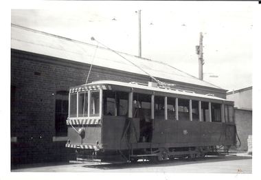 Bendigo Historical Society Inc.
Photograph - BASIL MILLER COLLECTION: TRAM AT DEPOT
Black and white photo of tram at depot. Tram has a crest on the side and contains a large horizontal tank.person, individual, basil miller -
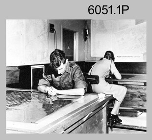 Bendigo Military Museum
Photograph - Retouching Reproduction Material at the Army Survey Regiment, c1960s, c1970s
The first four photographs were most likely taken in the 1960 and the fifth in the 1970s at the Army Survey Regiment, Fortuna, Bendigo. As there are no annotations with the photos, the exact dates, locations and names of personnel are unknown. SGT Bob Scaddan appears in the fifth photo taken in the 1970s Photos .1P and .2P. could have been taken in Lithographic Squadron’s retouching room and Photos .3P, .4P and .5P. were probably taken in Cartographic Squadron’s Correcting Section, located in the Attic. Retouching mainly entailed the application of liquid opaque (Plumtree), commonly known as “duff” to cover blemishes such as scratches and spots on film negatives before photographic exposure. Retouching technicians also used specialised techniques such as “needling” to repair faults on the emulsion of map reproduction material. The technician in photo .4P is needling a hydrographic feature on a drainage negative, with a zoom transfer scope projecting a scaled projected aerial photograph as a positional reference. This is a set of five photographs of technicians retouching reproduction material at the Army Survey Regiment, Bendigo. The photographs were printed on photographic paper and are part of the Army Survey Regiment’s Collection. The photographs were scanned at 300 dpi. .1) - Photo, black & white, c1960s. unidentified personnel in Lithographic Squadron. .2) - Photo, black & white, c1960s. unidentified personnel in Lithographic Squadron. .3) - Photo, black & white, c1960s. unidentified personnel in Cartographic Squadron Attic. .4) - Photo, black & white, c1960s. unidentified personnel in Cartographic Squadron Attic. .5) - Photo, black & white, c1970s. SGT Bob Scaddan in Cartographic Squadron..1P to .3P, .5P - annotated “Retouching”royal australian survey corps, rasvy, army survey regiment, army svy regt, fortuna, asr, litho, carto -
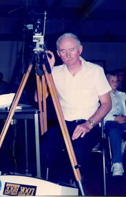 Sunbury Family History and Heritage Society Inc.
Photograph, School concert 1988, 1988
The man with the camera helped out at the Bulla Primary School with the audio-visual equipment. He was filming the children and community at the concert that the school had mounted, with the help of the community, in 1988. The concert took place at the Bulla Community Hall.A non-digital coloured photograph of a man seated behind a camera, which is mounted on a tripod.school concerts, bulla primary school -
Bendigo Historical Society Inc.
Archive - GOLDEN SQUARE SECONDARY COLLEGE, 1960-2008
DVD. Golden Square Secondary College, 1960-2008. Spirit of The Square -
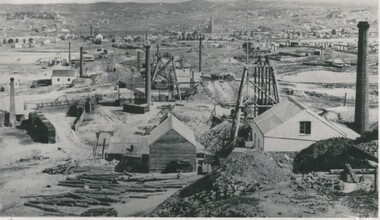 Bendigo Historical Society Inc.
Photograph - MINING AREA VIEW FROM NEW CHUM HILL, 1875
Black and white photograph. View overlooking mining area from New Chum Hill in the early 1870's showing four poppet legs and at least 9 chimneys (small chimneys and poppets at L distance). Golden Square Methodist Church C distance. Inscriptions: typed on front 'Looking South from New Chum Hill in early 1970's. The rich :Lazarus New Chum: in foreground. Other rich New Chum Mines in background'N J Caireplace, mining site, see also 2001.003.01 -
Moorabbin Air Museum
Manual (Item) - King VOR/LOC/GS Indicators Installation Manual, KI 202/203/204/206/207 Installation Manual
-
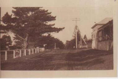 Phillip Island and District Historical Society Inc.
Photograph, The Esplanade, Cowes, Phillip Island
Photograph of old Post Office on right side looking towards to War Memorial. To left features white fencing and Cyprus trees.Looking along The Esplanade, Coweslocal history, photographs, the esplanade, cowes, streetscape, sepia photograph, mary karney -
Glenelg Shire Council Cultural Collection
Photograph - Photograph - Main Breakwater construction, Portland, 28/02/1957
Port of Portland Authority Archivesport of portland archives, main breakwater, portland, harbour, construction, crane -
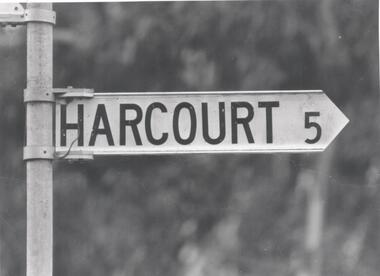 Bendigo Historical Society Inc.
Photograph - PHOTOGRAPH. HARCOURT SIGN POST
Photograph. Harcourt Sign Post. -
 Phillip Island and District Historical Society Inc.
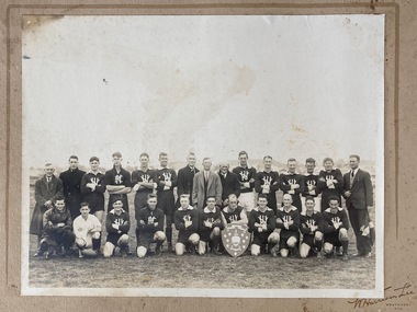
Photograph - Photo of local football team, Premiership photo of local football team
From the estate of Jack Jenner. Found at the Phillip Island Hotel, corner of The Esplanade and Osborne Ave, Cowes. Possibly given to L Wilson or J Edgar.(proprietor of the hotel and President? of Phillip Island Football Club). Collected by Edith Jeffrey. Black and White photo of football team, umpire and staff displaying shield, , mounted on cardboard.Found at Phillip island Hotel after condemned. Possibly given to L. Wilson or J. Edgar, J Jenner. [ W. Harrison Lee Studios, Wonthaggi , Vic. stamped on cardboard mount]football, jack jenner, sport, local sporting teams, photograph -
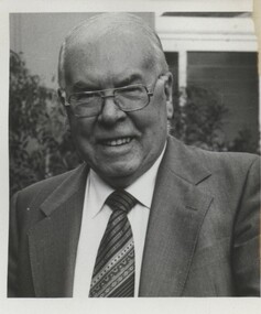 Vision Australia
Photograph - Image, Portrait of John Wilson
Portrait of John Wilson.B/W photograph of John Wilsonjohn wilson, association for the blind -
Glenelg Shire Council Cultural Collection
Photograph - Photograph - men in shark costume, Portland, n.d
Black and white photo. Two men, face on to camera, dressed in 'shark' costumes, head and open jaws with big teeth visible -
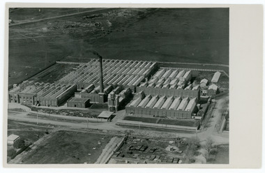 National Wool Museum
Photograph
Photographic postcard depicting the newly constructed Valley Mill, c.1923.Aerial view of the Valley Mill, c.1923.POST CARD / CORRESPONDENCE ADDRESS ONLY / KODAK / AUSTRALvalley worsted mill