-
 Moorabbin Air Museum
Document (Item) - Victa Airtourer 115 Operations Manual , Type Handling Notes
-
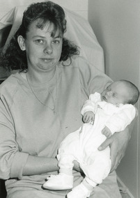 Lakes Entrance Regional Historical Society (operating as Lakes Entrance History Centre & Museum)
Photograph, Bairnsdale Advertiser, 1/08/1994 12:00:00 AM
Black and white photograph of baby Megan Siacci with mother Amandacelebrations -
Bendigo Historical Society Inc.
Document - FORTUNA COLLECTION: SAVE FORTUNA VILLA ATTENDEES AT MEETING, 2006
FORTUNA COLLECTION: SAVE FORTUNA VILLA ATTENDEES AT MEETING 'Save Fortuna Villa'. Held at the Bendigo Town Hall Reception Room on Tuesday 2nd May 2006 at 7 pm. Four pages of names.bendigo, clubs -
Lakes Entrance Regional Historical Society (operating as Lakes Entrance History Centre & Museum)
Photograph, Lakes Post Newspaper, 1996
number in album 03603.07Black and white photograph M Hibbins from Sale and J Pusmucans from Maffra, holding trophy A Grade Scratch, Golf Club. Lakes Entrance Victoriagolf club, sports -
Whitehorse Historical Society Inc.
Article, A Rowing national, 28/11/1993 12:00:00 AM
Photo and caption of Mario Lang of Mitcham participating in the 1993 world rowing championships.Photo and caption of Mario Lang of Mitcham participating in the 1993 world rowing championships.Photo and caption of Mario Lang of Mitcham participating in the 1993 world rowing championships.lang, mario -
Port Melbourne Historical & Preservation Society
Photograph - Entrance, Port Melbourne Football Ground, Williamstown Road, John May, 1996
A record shot taken by John May on restructuring of VFA, indicating inclusion of Traralgon in the league.Colour snapshot of Williamstown Road entrance to Port Melbourne football ground with sign indicating first game with Traralgon after club's entrance into the VFL (Victorian Football League, formerly VFA) Two copiessport - australian rules football, port melbourne football club, pmfc -
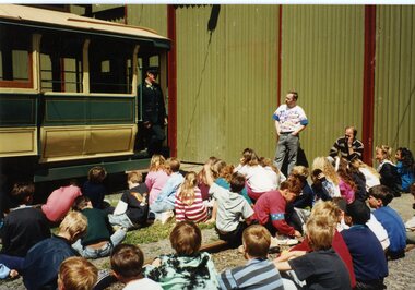 Ballarat Tramway Museum
Photograph - Colour Photograph/s, Leanne Fitzsimons, 1995
Colour photograph of Barry McCandlish talking to an assembled group of school children from the Melton West Primary School when they visited the Museum during 1995. Children sitting on the depot fan, while Barry stands on a step of tram 27. Another photo of the group is used on the front cover of the education kit. Photo taken by Leanne Fitzsimons, daughter of member/conductor Len Doull. On Kodak paper.school visits, melton west primary school, charters, education, tram 27 -
Whitehorse Historical Society Inc.
Document, Eastern Community Broadcasting, 1975
Folder containing a report to the Minister for the Media on the application for Eastern Community Broadcasting. Documents about the planning for the radio station and letters of support from the community. Also application for a grant of a licence for a low-coverage amplitude modulated restricted Commercial Broadcasting Station and Articles of Association of Eastern Community Broadcasting Pty Ltd.radio broadcasting, eastern community broadcasting, james, charles peter corby, lilburn, herbert stephen, smart, gerald richard, mcarthur, peter stewart, foster, yvonne, harris, peter william -
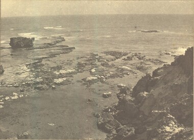 Port Fairy Historical Society Museum and Archives
Photograph
Black & white photograph of the rocky sea floor, waves and rocks of the Crags, Yambukbeach, sea, seascape -
University of Melbourne, Burnley Campus Archives
Article - Photocopy, Rowan Wilken, Horticulture for Women. A Foreword to thehistory of Australian Women Garden Designers, 1998
Photocopy of article in Australian Garden History, Vol. 9, No. 2, 1998, by Rowan Wilkenrowan wilken -
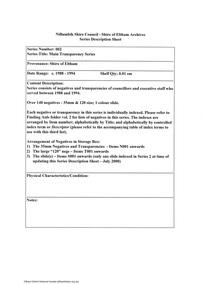 Eltham District Historical Society Inc
Document - Series Listing, Fraser Faithfull et al, Series 02: Main Transparency Series, 2000
Series consists of negatives and transparencies of councillors and executive staff who served between 1988 and 1994. Over 140 negatives - 35mm & 120 size; l colour slide.shire of eltham archives, series listing -
 Federation University Historical Collection
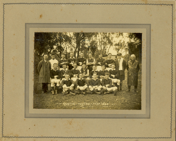
Photograph, N.R. McGeehan Photo, Gapsted Football Team, 1932
Gapsted is on the Great Alpine Road in the vicinity of Myrtleford, Victoria. John McNaughton studied at the Ballarat Teachers' College in 1929. He was most probably the teacher of Gapsted Primary School in 1932.Mouned black and white photograph of an Australian Rules football team and two officials. The official on the left is John McNaighton.gapsted, gapsted football team, mcnaughton, john mcnaughton -
 Bendigo Historical Society Inc.
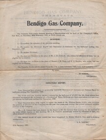
Document - AGENDA FOR MEETING - BENDIGO GAS COMPANY, 1921
Agenda for Meeting and Order of Meeting - Bendigo Gas Company. Half-yearly Ordinary Meeting of Shareholders. 24/2/1921. Business items; Director's Report; Financial Statements. H Johns, Sec. J B Young, Chairman.organization, business, bendigo gas company -
 National Vietnam Veterans Museum (NVVM)
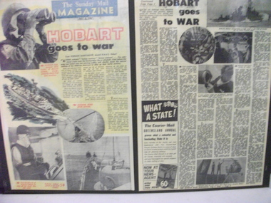
Document, Hobart goes to War, 2/07/1967 12:00:00 AM
Mounted Document. The Suday Mail Magazine article titled "Hobart goes to War" story and pictures of life on board HMAS Hobart on Patrol off North Vietnamdocument, hmas hobart, sunday mail magazine -
 Malmsbury Historical Society
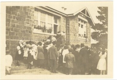
Photograph (Item), Crowd At Malmsbury Primary School C1930, Malmsbury c1930
People - "Young, Betty" Buildings - School Associated with - Reunion? -
Malmsbury Historical Society
Photograph (Item), Bert Morgan At Mhs Exhibition Sept 1991, Malmsbury 4/9/1991
People - "Morgan, Bert; Manktelow, Dennis" Buildings - Town Hall Associated with - "Mhs, Daffodil Festival?" -
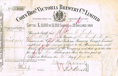 Bendigo Historical Society Inc.
Document - COHN BROTHERS COLLECTION: SHARE SCRIP
Cohns bros Victoria Brewery Co 100 Share scrip numbers 28126-28225 in the name of William E Seadon dated 31 st January 1888. Capital £ 55,000 in 55,000 Shares or twenty shillings each. Cohns seal impressed upon document. Transferred after his death to William Charles Vahland 50 shares, and to Ralph William Brown 50 shares on the Seventh of December 1905. Executors of his will 'The Union Trustee Company of Australia Limited. Document impressed with executors wax seal. One penny victoria stamp duty affixed to reverse of share scrip document paid in addition at rate of five shillings per share £25 authorised by E I hastings Secretary with February 1888 date. One penny stamp duty also affixed to transfer document.bendigo, industry, cohn bros., 19th century cohns bros share scrip. the union trustees company of australia. mr w e seadon. -
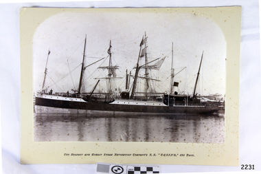 Flagstaff Hill Maritime Museum and Village
Photograph - Vessel, The Belfast and Koroit Steam Navigation Company's S.S. "Casino, 425 Ton, Late 19th to early 20th centuries
This black and white photograph shows the image of the coastal trading vessel S.S. Casino, with both sail masts and steam funnel. Men in hats are clearly visible on deck. The ship is in calm water and only light rigging is on the masts. Other vessels are in the background. Photograph is taken 1882-1932. The S.S. Casino was a passenger and freight steamer built in Dundee, Scotland, in 1882 for the Newcastle and Hunter River Steam Navigation Company of N.S.W. She weighed 425 tons gross with a length of 160.4 feet, beam of 24.1 feet and depth of 10.2 feet. She had saloon accommodation for 35 people, forecabin for 25 more people, and she carried 300 tons of cargo. While on her delivery journey on May 30th 1882 the S.S. Casino called in at the Port of Warrnambool for coal ., narrowly escaping going ashore in gale force winds due to the quick action of the pilot. At that time, still at anchor, she impressed the directors of the Belfast and Koroit Steam Navigation Company so much that they bought her immediately; she was ideal for trade in along the West Coast of Victoria. (Belfast is the original name for Port Fairy, South West Victoria. The Belfast and Koroit Steam Navigation Company was first managed by Messers. Saltau and Osburne and after the passing of Mr. Osburne, by produce merchants Messers H. Sautau and Sons, whose had a hay and corn store and shipping agency was on the corner of Liebig and Koroit Streets in Warrnambool. ) The S.S. Casino became “the most famous steamer to operate in Victorian waters along the West Coast” by author Jack Loney. Captain Boyd was her first Master, followed by Captain Chapman, who stayed with her 1890 until 1924. Captain W. Robertson followed for a short term, then Captain Middleton then took command 1925 - 1932. The S.S. Casino had several mishaps during her life. One was on 3rd January 1898 when she collided with the S.S. Flinders in Apollo Bay with minor damage. Another was on 24th October 1924 when she grounded on a reef at Point Hawdon near Grey River and most of her cargo (of Christmas goods) had to be dumped into the sea. Then in February 1929 she was ‘holed’ when she struck a submerged object as she entered Lady Bay, Warrnambool. On the morning of 10th July 1932, after attempting to berth at Apollo Bay jetty in heavy seas, Captain Middleton decided to take her out into the bay and wait until the seas abated. It was not realised that the anchor used to steady her as she manoeuvred to her berth had pierced her hull. She put about and headed for the beach but sank. Captain Middleton and nine others lost their lives; nine people were rescued including the two female passengers . Captain Middleton had been in charge of the S.S. Casino for seven years. He was the first ship’s Master to lose his life through shipwreck in the West Coast trade. In the years following the turn of the century the S.S. Casino remained the only regular trader with normal passenger accommodation along the West Coast. From 1882 she had made at least 2,500 voyages on the one run. Flagstaff Hill’s collection has a photograph of a portrait of Captain Chapman, , a ship model of the S.S. Casino that shows both forms of power under which she sailed, steam and sail. The ship is painted green and flies three flags. The inscription across the case of the ship model, incorrectly dated, tells the sad story of the wreck of the ship and the loss of lives on July 10th 1932 at Apollo Bay. A print in the Collection show S.S. Casino underway in heavy sea off Point Lonsdale, another two photographs show her at the Port of Warrnambool, leaving from the Breakwater in Lady Bay and another identifies the S.S. Casino as a ship from the Belfast and Koroit Steam Navigation Company. (Belfast is the original name for the township of Port Fairy). This photograph is significant because of its association with the coastal trader S.S. Casino and its significance to trade along Victoria's West Coast in the late 19th and early 20th century. It was taken 1882-1932 The wreck of the S.S. Casino is considered an important part of Victorian and Australian cultural heritage and as such has been declared and protected as an Historic Shipwreck under State and Commonwealth Law in the Commonwealth Historic Shipwrecks Act (1976). Photograph, black and white, taken 1882-1932. Foreground is vessel SS Casino, the Belfast and Koroit Steam Navigation Company's coastal trading ship. The ship, in calm water, has light rigging on its masts and also a steam funnel. One lifeboat is visible. People are on the deck. The background shows other vessels.Under the photograph "The Belfast and Koroit Steam Navigation Company's S.S. "Casino," 425 Tons"flagstaff hill, warrnambool, shipwrecked coast, flagstaff hill maritime museum, maritime museum, shipwreck coast, flagstaff hill maritime village, great ocean road, newcastle and hunter river steam navigation company, belfast and koroit steam navigation company, h. sautau and sons, s.s. casino, west coast trader s.s. casino, victorian coastal trader, captain boyd, captain w. robertson, captain chapman, captain middleton, apollo bay shipwreck, s.s. casino at lady bay warrnambool, saltau and osburne -
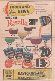 Bendigo Historical Society Inc.
Document - BENDIGO BUSINESSES COLLECTION: HAVECKINS
Eight pages advertising brochure for Haveckins self service crn. Condon and Neale Streets, Kennington. These specials available week of Wednesday 31st May, 1967. Foodland home news on the front Rosella soup.bendigo, business, haveckins -
 National Vietnam Veterans Museum (NVVM)
Photograph, APC's
Two times black and white Photograph of APC's and troops. Photo 1 - An unmanned APC sits unmanned near a tent camp. A C130 flys overhead. Photo 2- Two manned APC's on a village road nearby a river. ARVN and Australian troopers nearby.armoured personnel carrier, c-130 hercules, arvn, photograph -
 Melbourne Tram Museum
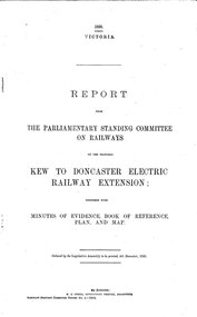
Document - Report, Victorian Parliament, "Report - The Parliamentary Standing Committee on the Proposed Kew to Doncaster Electric Railway Extension", Dec. 1930
Printed - 12 page foolscap, stapled on left hand side, 2 sections, Victorian State Parliamentary Report titled "Report - The Parliamentary Standing Committee on Railways on the Proposed Kew to Doncaster Electric Railway Extension", together with minutes of evidence, book of reference, plan and map, dated 4/12/1930. References a 1928 document, looks at construction costs, sites for railway stations, estimated revenue and expenditure, existing Kew line financials, town planning, bus services, MMTB input, tram services, alternatives, committee views, recommendations and a map of proposed routes, showing roads and tram services. Includes references to the Kodak estate and APM proposals at Fairfield. See Reg Item 2102.3 for the 1928 report.trams, tramways, doncaster, railways, public transport, kew -
Glenelg Shire Council Cultural Collection
Photograph - Photograph - Syd Cuffe, Town Crier, c. 1997
Syd Cuffe was the Portland Town Crier from 1983 to 2013. The role of Town Crier was created for Syd Cuffe in 1983 in the lead up to Portland’s 150th anniversary celebrations held in 1984-85. 200 items from Mr. Cuffe’s estate were donated to the Glenelg Shire Cultural Collection. The items relate to his town crying activities and community work across the Shire and further afield.Identification numbers 9020 a,b a) coloured photo, group of Town Criers in regalia, at the 7th World Crier Competition, Sidney BC Canada Sept 15-20 1977 b) Folder for above, grey card -
 Melbourne Legacy
Document, Blamey House
Documentation dated January 1974 obtained by Legatee Trebilcock as a member of the Steering Committee (Residences) which had been formed to advise on the future of the Melbourne Legacy residences. See also Cat.No. 01676. The document describes the location and the buildings in detail noting that the location on Burke Road is a very good one and the buildings were quite sound. See also Cat. No. 01677. Main building had been built about 50 years before and the annex 40 years before document. There was an asphalt tennis court used for basketball and a small library. Part of the history of Melbourne Legacy's involvement with residential care for children.Photocopies x 3 pages, with black type. residences, review, committee, blamey house -
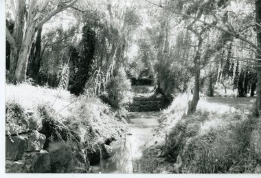 Ringwood and District Historical Society
Photograph, Mullum Mullum Creek- 29-10-89
Black and white photograph"Written on back of photograph" Mullum Mullum Creek North bank looking West Near Harrison St -
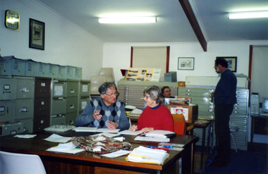 Whitehorse Historical Society Inc.
Photograph, Local History Room, 27/06/2001
Coloured Photo of Society Members at work in Local History Room. Front: Ted Arrowsmith, Rosalie Whalen, Back: David Harris, Peter Simmenauer.nunawading & district historical society, arrowsmith, ted, whalen, rosalie, harris, david, simmenauer, peter -
 Gippsland Art Gallery
Photograph, Oldfield, David, McNamara's Hut Replica, Buckety Plain, 2004
Donated by the artist, 2004Silver bromide photographic printgippsland, artwork, permanent collection -
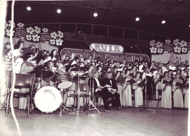 Vision Australia
Photograph - Image, 1974 Carols by Candlelight, 1974
Philip Gibb and Choirmaster Lawrence Warner sit on the stage, surrounded by choirs at the RVIB Carols by Candlelight performance in 1974. B/W photograph of choirs and special guests at Carols by Candlelightcarols by candlelight, philip gibb, lawrence warner -
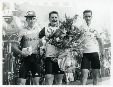 Bendigo Historical Society Inc.
Photograph - BENDIGO ADVERTISER COLLECTION: BIKES, 1990s
Photograph: Three men on bike racing winner's podium On Rear: Place getters, Stirling (2nd) Dove (1st) Brian Smith (UK) (3rd) TR10 CAP SLArecreations, sports, cycling, bendigo advertiser -
 Eltham District Historical Society Inc
Photograph - Aerial Photograph, Landata, Eltham; Crown Allotment 15, Section 5, Parish of Nillumbik (Stokes Orchard Estate), Oct. 1970
Centred on present day Diosma Rd, Stokes Pl, Nyora Rd and Eucalyptus Rd Historic Aerial Imagery Source: Landata.vic.gov.au Aerial Photo Details: Project No :1148 Project : MELBOURNE 1970 PROJECT Run : 27 Frame : 192 Date : 10/1970 Film Type : B/W Camera : RC8 Flying Height : 5100 Scale : 9600 Film Number : 2366 GDA2020 : 37°42'45"S, 145°10'05"E MGA2020 : 338533, 5824496 (55) Melways : 22 D4 (ed. 42) A History of the Development of Crown Allotment 15, Section 5, Parish of Nillumbik – Stokes Orchard Crown Allotment 15, Section 5, Parish of Nillumbik (CA15) is a square allotment of 158 acres or approximately a quarter of a square mile. It lies just beyond the eastern end of Pitt Street, south of Nyora Road to the northern end of Eucalyptus Road and extends east from Eucalyptus Road to Reynolds Road. The topography of CA15 is generally steep, sloping up to a hill near the centre of the land, the ridgeline passing through the properties along the southern side of Diosma Road. Eucalyptus Road is a straight north-south road with its northern end at the north west corner of CA15. Until the end of the 1970s this road was an un-named Government Road and was largely not open to traffic. With residential development in the 1970s the road was constructed, and the council allocated the name obviously in recognition of the predominant species of the local bushland. CA15 was purchased from the Crown by George D’Arley Boursiquot, a prominent Melbourne printer, on 28th October 1852. On November 23, 1922, former Member for Gippsland and Melbourne Real Estate Agent, Hubert Patrick Keogh purchased the allotment then sold it March 13, 1925, to local farmer, Robert David Taylor, a former Shire of Eltham Councillor (1911-1920) and Shire President (1919). Taylor had extensive land holdings stretching west towards Bible Street and Main Road. The Taylor home was situated at the top of the hill in Bible Street at present day 82 Bible Street. At the time of Taylor’s purchase in 1925, CA15 was subdivided into 48 lots that could be described as small rural properties or large residential lots. A typical lot size was one hectare or 2.5 acres. The subdivision created two roads, Nyora Road, and Diosma Road, each following an irregular alignment between Eucalyptus and Reynolds Roads. However, the lots were not sold off separately nor were the roads constructed. The land effectively remained as one parcel for many further years. Robert David Taylor died November 30, 1934, and probate was granted to his son of the same name, Robert David Taylor of Bible Street, Salesman and William McLelland Vance Taylor of 73 Emmeline Street, Northcote, Clerk, with the transfer of the land into their names on July 8, 1935. Frank Stokes worked as a qualified accountant at Kennons leather factory in Burnley, while living at 1 Thomas Street, Mitcham. He suffered from migraines and wanted to return to working the land (he had previously worked on farms and orchards since coming to Australia from England in 1926, both in WA and Vic.). He first travelled to the district by train in July 1942 to find land with the intention to establish an orchard. By chance he met Arthur Bird of Bird Orchard (bounded by Pitt Street, Eucalyptus Road, and Wattle Grove) and they got talking over their common interest. Arthur put Frank up for the night and pointed out the land, 158 acres- part of the Taylor Estate- £900, Crown Allotment 15, Section 5, Parish of Nillumbik (CA15) somewhat diagonally opposite Bird Orchard. Stokes applied through the Riverina Agency to purchase the land who in turn applied for permission from Canberra to sell as there was a new government regulation introduced during the Second World War banning land sales except for immediate production. Stokes obtained a loan on his Mitcham house of £600 @ 5% and paid £450 deposit with quarterly payments of £15 spread over 5 years. Stokes was assisted and advised by Arthur Bird who farmed the neighbouring orchard. In early 1943 Stokes took possession and would catch the train out to Eltham on Fridays after work and began building a hut on the corner of Nyora Road and the Government Road (Eucalyptus Road) for shelter and to lock up tools. He established an orchard on the central western part of the land through the centre of which ran a natural waterway (part of the present-day linear park) and was able to pay a neighbour (Hawkins) to help with clearing and fencing 25 acres, and with a horse and single furrowed plough, planted approximately 2,500 fruit trees - cherries, peaches, plums, almonds, pears, apricots and lemons as well as a few apples and oranges; a massive task. Aerial photographs from the 1940s through to the 1990s clearly show the orchard with most of the larger CA15 site remaining as natural bushland. A huge problem was hares and rabbits eating all the new buds off the tiny trees. As well as laying poison he painted the trees with a mixture of cow manure and lime, often working by moonlight. Procurement of wire and wire netting was difficult because of the war but after much effort he obtained a permit from the Agricultural Department for supplies in March 1944. In February 1945 Stokes applied for a permit to build a “packing shed” as no house building was allowed. It was to be 33 feet x 21 feet and cost £312. It was constructed mostly from second-hand materials, which were hard to obtain, especially iron for roofing. Stokes finished work at Kennons on October 31, 1945, and in March 1946 he sold the family home at Mitcham for £1,230 plus £170 for furniture. On May 15, 1946, title to the CA15 property was issued to Frank Howard Alfred Stokes, Orchardist and Gladys Ethel Stokes, Married Woman, both of Pitt Street, Eltham. The family of five then moved into the very unfinished “packing shed” at Eltham, which was a struggle to weatherproof. Eventually rooms were divided off and lined with hessian bags and whitewashed. Their income was firewood (cut and sold), selling rockery stones and cut Sweet Bursaria. (It was discovered during the 1940s that Sweet Bursaria contained the sunscreen compound Aesculin. The RAAF utilised this compound from Sweet Bursaria during WW2 for pilots and gunners.) The orchard’s first fruit sale was a half-case of Le Vanq peaches in December 1947 for the price of 8 shillings. In 1956 plans for house were drawn and Glen Iris bricks purchased (1956 Olympic Rings variant). The building of the house commenced in 1957 - 12 feet of original packing shed was removed – and was completed in 1959. Water was connected from newly built pressure storage on the property at the end of 1959 and the electricity connection for the first time at 3pm on April 29, 1960. The house remains to present day (somewhat modified) at 1 Nyora Road, home to Nyora Studio Gallery. On occasions, spare remnants of the 1956 bricks have been known to be unearthed in gardens on the estate as they were utilised by Frank Stokes to fill in rabbit holes. On May 26, 1950, a parcel of land was compulsorily acquired by the Melbourne and Metropolitan Board of Works on the hilltop to establish an easement for a high-level service reservoir to augment Eltham’s water supply. The project also included pipe tracks for the necessary water mains. The reservoir has now been superseded by higher level water tanks east of Reynolds Road and its former site is now a public reserve. On November 27, 1964, the State Electricity Commission served notice to compulsorily acquire a further parcel through the eastern part of the land for a major electricity transmission line that augmented supply from the La Trobe Valley to Melbourne. The easement was registered February 11, 1966. The easement was widened July 18, 1969 for a second transmission line to be constructed. In 1971 Melbourne Metropolitan Planning Scheme amendments adopted Nyora Road as the boundary between a residential zone to the north and a rural zone to the south. This determined the future development of the land. In the mid-1970s the Shire of Eltham divided the orchard into numerous rate-able parcel lots, the 48 lots having been established in 1925 and the subsequent rates assessment proved unsustainable for Stokes. He commenced selling lots outside the boundary of the orchard, north of Diosma and South of Nyora. However shortly later the land between Nyora and Diosma Roads and west of the electricity easement was sold and subdivided into residential lots, a housing development by Macquarie Builders and marketed as the Stokes Orchard Estate. New streets were created, and most were named after trees, although one, Stokes Place, commemorates the former owners. The development was undertaken in two stages; Stage 1 (1975) encompassing Scarlet Ash Court, Ironbark Close and Peppermint Grove bounded by Nyora and Eucalyptus roads and Stage 2 (1978) encompassing Stokes Place, Orchard Way, The Crest and The Lookout bound by Nyora and Diosma roads. The developer, Macquarie Builders went bankrupt shortly after the release of Stage 2 leaving many purchasers to fend for themselves and arrange for their own independent builders. There were also difficulties with sewerage for the land immediately south of Diosma Road and so the conventional residential lots were abandoned in favour of larger lots. The development of Orchard Way, The Crest and The Lookout did not proceed as planned and the proposed lots were incorporated into five-acre parcels instead. These included a low-density group housing development by the Graves family and the award winning Choong House (1983) with Gordon Ford developed garden immediately next door situated on the ridge of the hill nestled amongst the original bush, Eucalypt trees and Sweet Bursaria. In 1994, Nillumbik Shire Council applied Significant Environment and Significant Landscape overlays upon the properties on the south side of Diosma Road to ensure protection of this natural bush garden environment. With the arrival of the sewer along Diosma Road in the 1990s, most of these five-acre parcels have since been subdivided multiple times. The Choong house presently sits on a 2.7-acre property, which in 2022 Nillumbik Council nominated for Cultural Significance Heritage protection and is considered potentially significant at State level. The Stokes family were also associated with the Eltham Christian Church. In the 1970s this church had met in temporary premises in Eltham. Lots of the original 1925 subdivision remained south of Nyora Road and a number of these lots were utilized for the Eltham Christian School, which was established by the Eltham Christian Church in 1981. The school operated on this site until 2000. The premises are now used by The Vine Baptist Church. By the mid-1980s the whole of CA15 had been developed for residential and school purposes, except for the sections north of Diosma Road and between the transmission lines and Reynolds Road. Sewerage issues had been resolved for the section north of Diosma Road and in 1987 it was in the process of being subdivided into residential lots. The development coincided with the discovery of colonies of the rare and endangered Eltham Copper Butterfly on the site. This resulted in a community and political campaign to save the butterfly habitat. With the co-operation of the land developer the subdivision was altered to create two bushland reserves in the critical butterfly habitat areas. In the late 1980s the State Government was investigating options for establishing a metropolitan ring road link between Diamond Creek and Ringwood. The chosen route was adjacent to Reynolds Road and so this created a freeze on development of CA15 between Reynolds Road and the electricity easement. The ring road proposal was eventually abandoned, and this part of the land was subdivided into low density residential lots. Diosma Road has been discontinued at the electricity easement and the eastern part incorporated into View Mount Court with access from Reynolds Road. The whole of CA15 has now been developed for residential or associated purposes, ranging from conventional density to quite low density south of Nyora Road. Some remnants of the orchard remain, a few cherry trees on the Graves property and a lone apple tree in Stokes Place. The butterfly reserves comprise significant areas of remnant bushland. Linear reserves through the estate link with central Eltham via the Woodridge linear reserve and with Research along the electricity easement. CA15 as it exists today has a complicated history of rural use, Government acquisition, urban development, and community action. References: • “Stokes Orchard, an incomplete history”; Russell Yeoman with Doug Orford • Correspondence, Beryl Bradbury (nee Stokes) • Aerial Photographs, 1931-1991, Landata (landata.vic.gov.au) • Certificate of Title, Vol. 4930 Fol. 985900 • Plan Number LP 10859 aerial photo, diosma road, eltham copper butterfly, eucalyptus road, ironbark close, nyora road, peppermint grove, peter & elizabeth pidgeon collection, power transmission lines, reynolds road, scarlet ash court, stokes orchard estate, stokes place, woodridge estate, frank stokes -
 Queenscliffe Maritime Museum
Photograph - 3 Photos of people involved in the rescue of crew from the 20t sailboat MERLAN, B&W photos of rescue team 16 Jan 1949, c1949
Lifeboat rescue crew 19491949 rescue crewSir T Maltby & guests, rescuers & crew of the MERLAN 1949, dinner.Reverse " NIL "lifeboat 'queenscliffe', lifeboat crew, football team