-
 Whitehorse Historical Society Inc.
Article, Vale Wall Riddell, 2013
Obituary for Wal Riddell, former Nunawading Mayor.Obituary for Wal Riddell, former Nunawading Mayor, explaining his connection with Cystic Fibrosis.Obituary for Wal Riddell, former Nunawading Mayor.riddell, wal, cystic fibrosis association of victoria, mayors -
Stawell Historical Society Inc
Article - Realia, Glass Window Panel A.W. Whiteside, c1890
Tailors Apparel for Men Location 44 Main Street Stawell Currently AutoproBeveled Glass panes with Gold Leaf, Ornate Initials. A.W. Interwoven with Swag for men's apparel.A W Interwoven, For Men's Apparelshop, business -
Bendigo Historical Society Inc.
Map - CAMPBELL COLLECTION: BENDIGO AND DISTRICT MAPS, 30-1-29
Map. Ellesmere, Parish of Ellesmere, scale 20 chains to 1 inch. Total area 3926 acres. Prepared in W.P.B. from A. and P. Plans, by W.J. Galbraith, 30-1-29, to Bendigo along Fosterville. (number 381 in map cupboard 1)W.J.Galbraithmap, bendigo, agricultural lands -
Bendigo Historical Society Inc.
Map - FORTUNA HUSTLER'S MINE - PLAN OF FORTUNA HUSTLER'S MINE
Map and plan of the Fortuna Hustler's Mine on the Hustler's Line of Reefs. Bulletin No 33, Plate No 1. Plan gives depth of the different levels. Bendigo Railway Station is on the map and also a number of the streets. Carpenter Street is called Cemetery Road. Also on the Hustler's Line of Reef is the Summer Hill Shaft. Shown is the Hustler's Royal Reserve No 2 Lease. Map has the Geological Survey of Victoria crest. It is signed by H Whit ?an Underground Survey Office Bendigo, September 1913. This item has not been scanned or photographed.map, fortuna hustler's mine, plan of fortuna hustler's mine, hustler's royal reserve no 2 lease, summer hill shaft, hustler's line of reef -
Whitehorse Historical Society Inc.
Article, Slater/Pearce families, 2008
Family history information about the Slater and Pearce families.Family history information about the Slater and Pearce families.Family history information about the Slater and Pearce families.slater family, pearce family -
Whitehorse Historical Society Inc.
Article, Preserving the past for the future, 1972
Article on Nunawading Historical Society with photos of Maurice Chatwin, Keith Patterson and Anis Poussard.Article on Nunawading Historical Society with photos of Maurice Chatwin, Keith Patterson and Anis Poussard.Article on Nunawading Historical Society with photos of Maurice Chatwin, Keith Patterson and Anis Poussard.nunawading historical society, chatwin, maurice, patterson, keith arthur, poussard, anis -
 Greensborough Historical Society
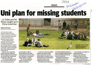
Article - Newspaper Clipping, Anthony Piovesan, Uni plan for missing students, 26/02/2020
Means of providing study plans for Chinese students unable to enter Australia owing to coronavirus restrictions are being provided by La Trobe UniversityNewspaper clipping, text with colour photograph, by Anthony Piovesanla trobe university, international students, covid pandemic -
 Greensborough Historical Society
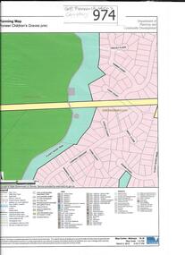
Map, Pioneer children's graves precinct, 1848-1860
Map showing the location and surrounds of Pioneer Children's Cemetery on the Plenty River in Greensborough. Children from pioneer families are buried here.Official government planning map for the Pioneer Children's Graves Precinct.Printed coloured copy of map of Plenty River areapioneer childrens cemetery, greensborough, partington, whatmough -
Stawell Historical Society Inc
Map, The Township of Elmhurst, Parish of Glenpatrick, Wimmera District
The Township of Elmhurst, Parish of Glenpatrick, Wimmera Districtstawell -
Bendigo Historical Society Inc.
Map - NERRING : COUNTY OF BENDIGO, August 1952
Map. Nerring, County Of Bendigo. Yarraberb, Neilborough, Huntly, Sandhurst, Leichardt, Marong. Drawn and reproduced at the Department of Lands and Survey, Melbourne,Victoria. August 1952, Price 2/-. By Appointment J.J. Gourley, Government Printer, Melbourne. (number 0 in map cupboard 1)J.J. Gourley,Government Printermap, bendigo, nerring -
Bendigo Historical Society Inc.
Map - UNITED HUSTLER'S & REDAN MINE - TRANSVERSE SECTIONS N & S OF SHAFT UNITED HUSTLER'S & REDAN MINE
Transverse Sections N & S of Shaft United Hustler's & Redan Mine on the Hustler's Line of Reef Bulletin No 33, Plate No XXX. Map shows some of the stone encountered on the levels and depth. Geological Survey of Victoria emblem and signed by H A Whitdan, Underground Survey Office Bendigo, September 1913.mining, parish map, united hustler's & redan mine, transverse sections n & s of shaft united hustler's & redan mine, hustler's line of reef -
 Whitehorse Historical Society Inc.
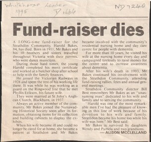
Article, Fundraiser Dies, 1995
Harold Bakes death notice.Death of Harold Bakes in 1995 and his involvement in fund raising for Strathdon for more than 10 years.Harold Bakes death notice.strathdon community, bakes, harold arthur, nunawading historical society -
Whitehorse Historical Society Inc.
Article, Vermont - the late Mr H Hatfield, 1920s
Harry Hatfield, 30, a past Chief Ruler of the Vermont Tent IOR and a highly esteemed Vermont resident, died as a result of a car accident.Harry Hatfield, 30, a past Chief Ruler of the Vermont Tent IOR and a highly esteemed Vermont resident, died as a result of a car accident.Harry Hatfield, 30, a past Chief Ruler of the Vermont Tent IOR and a highly esteemed Vermont resident, died as a result of a car accident.independent order of rechabites. vermont tent, hatfield, harry -
 Whitehorse Historical Society Inc.
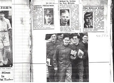
Article, Killed in Action, 1944
Copy from Mrs Jessie Williams' scrapbook of articles in 'The Sun' from the early 1940's announcing the names of men killed or missing in action during World War IICopy from Mrs Jessie Williams' scrapbook of articles in 'The Sun' from the early 1940's announcing the names of men killed or missing in action during World War II including Flying Officer F.R. Tickle, Private John Dalley and Sgt Pilot Stan Hattersley.Copy from Mrs Jessie Williams' scrapbook of articles in 'The Sun' from the early 1940's announcing the names of men killed or missing in action during World War II world war 1939 - 1945, tickle, f. r., dalley, john power, hattersley, stan, williams, jessie -
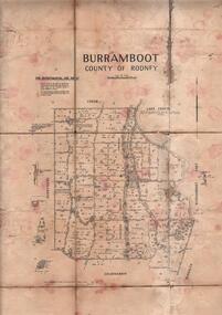 Bendigo Historical Society Inc.
Map - JACK FLYNN COLLECTION: BURRUMBOOT, August 1951
Map: Parish of Burrumboot, County of Rodney. Parish plan.By Authority J.J. Gourley, Government Printer Melbourne. Drawn and Reproduced at the Dept of Lands and Survey, Melbourne, Victoria. August 1951map, rodney, parish plan, burrumboot, rodney -
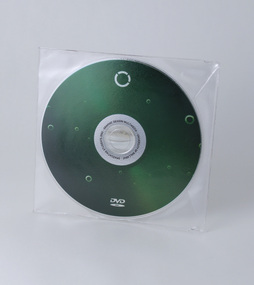 Federation University Historical Collection
Article - DVD student catalogue, One, 2002
DVD rom in clear plastic case created by University of Ballarat, Bachelor of Visual Arts (Graphic Design / Multimedia) third year, graduating students, 2002. DVD successfully tested on vintage Macintosh G4 with Mac OS 9.2.2 22 Students: Kristian Pechotsch, Josh McGregor, Stuart Murray, Dean Gorell, Mary Thomas, Simon Hunt, Michael Renga, Kristen Retallick, Alana Smyth, Claire Robson, Jarred Rouhan, Stuart Sullivan, Glen McClay, Leigh Ryan, Luke Monssen, Daniel Buckingham, Melissa Price, Rose Kim, Melinda Radojevic, Claire Hards, Dominic Carey, Peta Wallace. A square format case version was also produced (see photos for 29178.2).Optical disc (DVD rom) in clear plastic case. created by University of Ballarat, Bachelor of Visual Arts (Graphic Design / Multimedia) third year, graduating students, 2002.university of ballarat, federation university, graphic design, multimedia, camp street campus, new north, arts academy, kristian pechotsch, josh mcgregor, stuart murray, dean gorell, mary thomas, simon hunt, michael renga, kristen retallick, alana smyth, claire robson, jarred rouhan, stuart sullivan, glen mcclay, leigh ryan, luke monssen, daniel buckingham, melissa price, rose kim, melinda radojevic, claire hards, dominic carey, peta wallace. -
Whitehorse Historical Society Inc.
Article, Students
Pictured 4 students from Vermont Secondary College working together to solve a maths-engineering problem for the Tournament of Minds event.secondary schools, vermont secondary college, parry, stephanie, lulianetti, tenille, cheng, jason, chambers, chris, tournament of minds -
Bialik College
Article (sub-series) - Newspaper clippings, 2001-2002
2000s2000s -
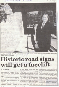 Whitehorse Historical Society Inc.
Article, Historic road signs will get a facelift, 1/01/1998 12:00:00 AM
Whitehorse Council will restore 75 year old signs painted under the Laburnum railway viaduct.Article from Whitehorse Gazette 21/1/1998 informing that Whitehorse Council will restore 75 year old signs painted under the Laburnum railway viaduct. The signs which have been vandalised and have badly deteriorated have been described as a Blackburn icon and a reminder of the past before traffic lights and road signs existed.Whitehorse Council will restore 75 year old signs painted under the Laburnum railway viaduct.city of whitehorse, abbott, kevin, champion, isaac, ray, shire of blackburn and mitcham, shire of nunawading -
Whitehorse Historical Society Inc.
Article, Kindergarten facilities can meet needs
Forest Hill Residential Kindergarten for Emergency Care facilities could be used by groups from Nunawading following closure in 1990 after 65 years.Forest Hill Residential Kindergarten for Emergency Care facilities could be used by groups from Nunawading following closure in 1990 after 65 years. With photo.Forest Hill Residential Kindergarten for Emergency Care facilities could be used by groups from Nunawading following closure in 1990 after 65 years. child care, forest hill residential kindergarten, holder, audrey, syme, wendy, lerk, diana -
Glen Eira Historical Society
Article - Glen Eira Saints Auskick Centre
This file contains one item. An article from the Caulfield/Port Phillip Leader on the selection of Glen Eira Auskick Centre as the weekly winner of NAB’s Footy Frenzy promotion dated 31/05/2011.glen eira, auskick, auskick centre, nab, national australia bank, footy frenzy, rossiter tim, glen eira saints, packer park, leila road, carnegie, football, sports, recreations, australian rules football, competitions, entertainment, sporting clubs, associations, football clubs, clubs, leisure, cultural events, cultural activities, sports establishments, recreations establishments, sports people, sportsgrounds, ovals, playing fields, parks, reserves, caulfield/port phillip leader -
 Glen Eira Historical Society
Article - Outer Circle Linear Park
OUTER CIRCLE LINEAR PARK, joint submission by cities of Kew, Camberwell, Malvern and Caulfield. A bound fifteen page submission, dated 08/07/1985, by four councils urging the creation of the Outer Circle Linear Park. Includes map and photographs. OUTER CIRCLE RAILWAY: A PLAN FOR A LINEAR PARK, report of the Outer Circle Study Group. Bound booklet of one hundred and thirty five typewritten and photocopied pages about the creation of this park. The Introduction was signed by Tom Roper, Minister for Planning and Environment, and by Joan Kirner, Minister for Conservation, Forests and Lands. Undated but the Introduction states that public submissions must be received by 31/05/1988. Includes maps, sketches of proposed facilities, a history of the former Outer Circle Railway Line, and a description of notable plants and trees. A double sided, one page leaflet, published by the Murrumbeena Outer Circle Parkland Retention Group, MOCPRG, with timeline of the park and map. Undated but the last date on the timeline is 1985. Includes small sheet headed WHAT CAN YOU DO? Cutting from the CAULFIELD CONTACT titled A NEW PARK IT’S OFFICIAL, dated 26/02/1988, on official announcement of the new park. Two copies of OUTER CIRCLE LINEAR PARK, a four paged pamphlet published by Outer Circle Linear Park Implementation Committee on the new park. Includes detailed map. Letter between Felicitie E. Campbell of the Caulfield Historical Society, dated 14/09/1988 supporting the naming of a section of the Linear Park as Boyd Park. Two pages typed and a hand written copy. Also a type written letter from Jim Badger, Manager, Cultural Services, City of Caulfield, supporting the naming as Boyd Park, dated 16/08/1988. An album of thirty five colour photographs by Peter Foeden and Associates, of the official opening of the Outer Circle Linear Park by Premier John Cain, 1988. Photographs are numbered and the album includes handwritten descriptions of each photograph. Two mounted photographs of the Caulfield section of Linear Park, undated. One black and white and one colour.outer circle linear park, outer circle railway, parks, saunders r. e., briggs a. g., quinn m., rudski b., outer circle study group, roper tom, kirner joan, dunstan david, railways, trees, murrumbeena, campbell felicitie e., badger jim, peter foeden and associates, campbell adack, lang robert, gallney cr., cain john, cain nancy, boyd john, boyd arthur, boyd merric, boyd penleigh, boyd robyn, boyd james, boyd guy, ballantyne mr. -
Whitehorse Historical Society Inc.
Article, Walk a while, 22/04/1992 12:00:00 AM
Article in Nunawading Gazette, 22 Apr 1992, on David Moss.Article in Nunawading Gazette, 22 Apr 1992, on David Moss, foundation member of Blackburn Tree Preservation Society who organises regular country walks. He also founded the Mitcham Film Society.Article in Nunawading Gazette, 22 Apr 1992, on David Moss.moss, david, mitcham film society, blackburn and district tree preservation society -
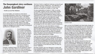 Whitehorse Historical Society Inc.
Article - John Gardiner, 23/06/2021
John Gardiner was born in Dublin 1798. He was a pastoralist and banker and arrived at Port Phillip in 1836 and with his cousin William Fletcher laid claim to 15,000 acres at the junction of the Yarra River and Kooyongkoot CreekJohn Gardiner was born in Dublin 1798. He was a pastoralist and banker and arrived at Port Phillip in 1836 and with his cousin William Fletcher laid claim to 15,000 acres at the junction of the Yarra and Kooyongkoot Creek.non-fictionJohn Gardiner was born in Dublin 1798. He was a pastoralist and banker and arrived at Port Phillip in 1836 and with his cousin William Fletcher laid claim to 15,000 acres at the junction of the Yarra River and Kooyongkoot Creekgardiner john, gardiners creek -
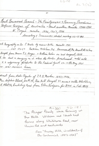 Whitehorse Historical Society Inc.
Map, Frank Ainger, 1873
Application by Frank Ainger for land in the Parish of Nunawading on Whitehorse Road near Mitcham Road. Also included are several references from other sources to Frank Ainger.ainger, frank, shire of nunawading, mitcham, land settlement -
Bendigo Historical Society Inc.
Map - COMET MINE - TRANSVERSE SECTION COMET MINE
Transverse section of the Comet Mine on the Hustler's Line of Reef Bulletin No 33, Plate No XXV signed by H. A. Whitdon, Underground Survey Office Bendigo September,1913. Map shows depth of the different levels, the type of stone and shaft about 2020 deep. A number of smaller drawings on the side.Reference explaining ther different types of stone, etc. This item has not been scanned or photographed.Geological Survey of Victoriamining, parish map, hustler's line of reefs, transverse section of comet mine bulletin no 33 plate no xxv, lightning hill line of reef -
Glen Eira Historical Society
Article - ST KEVIN'S CATHOLIC CHURCH, GLEN ORME AVENUE
Caulfield/ Port Phillip Leader – April 19, 2010 – announcing performance of tenor Maurice Connell at St Kevin’s Catholic Church – Ormond at 3pm on Good Fridaycaulfield, musical events & activities, st kevin’s catholic church, operas, connell maurice, ormond, murrumbeena, glen orme ave -
University of Melbourne, Burnley Campus Archives
Article - Biography, Daniel McAlpine: a pioneer plant pathologist of Australia, 1976
Daniel McAlpinePart of copy of biographical profile of David McAlpine, who officially opened the college in 1891. Daniel McAlpine was Vegetable Pathologist. The profile was written by Stanislaus Fish former Head of the Victorian Plant Research Institute. There is a photograph of Daniel McAlpine accompanying the profile. Daniel McAlpine's dates are 1949-1932. The copy has 2 handwritten notes APPS March 1976 (Australian Plant Pathology Society) ""To Eric Littlejohn, with Kind Regards Stan Fish" This profile might be from the Society's Newsletter. daniel mcalpine, plant pathologist, apps, australian plant pathology society, vegetable pathologist -
Whitehorse Historical Society Inc.
Map, Aston, 1989
Map of the Commonwealth Electoral Division of Aston. Scale 1:25,000Map of the Commonwealth Electoral Division of Aston. Scale 1:25,000Map of the Commonwealth Electoral Division of Aston. Scale 1:25,000electoral boundaries, aston (commonwealth electoral division) -
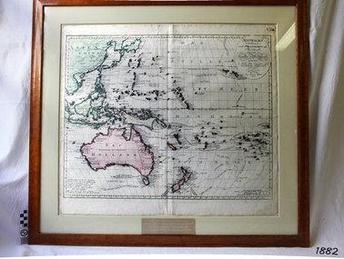 Flagstaff Hill Maritime Museum and Village
Map, Australien (Sudland) auch Polynesien oder Inselwelt, insgemein der funfte Welltheil, c.1990
This map is a reprint of Johann (Johannes) Walch’s “Australien (Sudland) auch Polynesien oder Inselwelt, insgemein der funfte Welltheil”, published in 1802. It shows Australia, New Zealand, South East Asia and the Pacific Islands shows a large number of places names, many of which have changed since the map was drawn. The map includes the routes and dates of the voyages of Tasman, Cook, Bougainville, Carteret, Byron, and others up to 1802. The shapes of the lands on this early map show that some of the areas had not yet been charted. The map was donated to Flagstaff Hill Maritime Village in April 1990 by the Group Study Exchange Team from Rotary District 233, Sweden. It was framed and presented by Rotary District 978 and presented by Barry Lange, the Governor of District 978 in 1989-90. (District 978, Geelong East, is now District 9780.) Johann (Johannes) Walch Johann Walch, painter and engraver, was born in 1757. He was well known for creating miniature portraits. He gained his training in Geneva, Venice and Rome. His publications include atlases and sheet maps, many of which were reprinted after his death in 1816. This reprint of an 1802 is significant for its historical and geographical contant, showing the voyages of many early explorers to the southern regions of the world including Australia. It also shows the early names used for countries and towns and is a valuable reference to historical interpretation. The map itself is a fine example of hand drawn and hand coloured maps of the early 19th century, the method of production, detail included, layout, symbols and so forth.Map, reprint of Johann (Johannes) Walch’s “Australien (Sudland) auch Polynesien oder Inselwelt, insgemein der funfte Welltheil “, first published by in Ausburg in 1802. The image on this Map No 5B, shows Australia and the south Pacific. The timber framed, glass covered, printed and coloured map was created in two sections and joined. Brass plaque at base of map states that the map was presented to Flagstaff Hill by Rotary International in April 1990. Feint lines used for aligning lettering can be seen on the map and there are large erased letters such as a “D” and “S” that are almost obscured.Plague “ROTARY INTERNATIONAL / THE MAP WAS DONATED BY THE GROUP STUDY EXCHANGE TEAM / FROM ROTARY DISTRICT 233 SWEDEN IN APRIL 1990 / AND WAS FRAMED AND PRESENTED BY ROTARY DISTRICT 978 / BARRY LANGE – GOVERNOR DISTRICT 978 1989/90” Stamped on back “ELLIMINOOK FRAMES / MRS. JILL FALKINER / ELLIMINOOK / BIRREGURRA, VIC. 3242 / PHONE: (052) 36 2080” flagstaff hill, warrnambool, shipwrecked coast, flagstaff hill maritime museum, maritime museum, shipwreck coast, flagstaff hill maritime village, great ocean road, australien (sudland) auch polynesien oder inselwelt, insgemein der funfte welltheil, johann (johannes) walch, cartographer johann (johannes) walch, ausburg publisher johann (johannes) walch, johann (johannes) walch map number 5b, 1802 map of australia and south pacific, rotary international group study exchange team, rotary district 233 sweden, elliminook frames, voyages of tasman, voyages of cook, voyages of bougainville, voyages of carteret, voyages of byron, barry lange, painter of miniature portraits johann (johannes) walch