-
 Melbourne Tram Museum
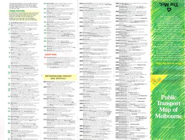
Map, The Met, "Public Transport Map of Melbourne" - "Effective August 1988", 1988
Map - Pocket size - folded - public transport map of Melbourne, printed in colour on art paper, showing public transport services in greater Melbourne, an index of localities. The City Saver area shown in detail. On the rear, route numbers, line maps of tram routes, train lines, outer metropolitan services, ticketing information, Transport Neighbourhoods, . Shows the St Kilda and Port Melbourne light rail lines. Price $2. Shows "The Met" logo. On front under The Met logo and above the scale bar is "Effective 1/7/1988".In ink in top left hand corner, "11" in a circle.trams, tramways, melbourne, map, routes -
 Whitehorse Historical Society Inc.
Article, One stop family centre, 1996
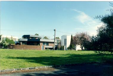
Box Hill South Family Centre opensBox Hill South Family Centre opensBox Hill South Family Centre openslocal government, city of whitehorse, hallam, roger, randell, shirley, box hill south family centre -
 Whitehorse Historical Society Inc.
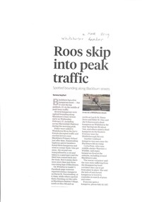
Article, Roos Skip Into Peak Traffic, 2019
Several kangaroos were reported bounding along Blackburn's busy streets early on February 27th.Several kangaroos were reported bounding along Blackburn's busy streets early on February 27th having been attracted to roadsides in search of grass & water during our prolonged dry spell.Several kangaroos were reported bounding along Blackburn's busy streets early on February 27th. wildlife, blackburn, whitehorse road, blackburn, warriors 4 wildlife -
 Melbourne Legacy
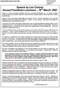
Article - Speech, Past Presidents' Lunch - Les Carlyon, 2007
A copy of an article from the Bulletin recounting the speech by Les Carlyon at the Past Presidents' lunch on 18th March 2007. He chose to talk about Sir John Gellibrand and his war service and personality. He quoted Charles Bean in 1944 "There was a time when some of us thought that the best monument to John Gellibrand might be the story of Second Bullecourt. Now I feel there will be an event better monument - the record of Legacy." Document was from a folder of documents donated to the archive by Legatee Bill Rogers that related to his time as President (March 2006 - March 2008).A record of John Gellibrand's war service in WW1.Three A4 page photocopy of an article published in the Bulletin 5 April 2007 of a speech by Les Carlyon at the Past Presidents' lunch on 18 March 2007.sir john gellibrand, charles bean -
 Bialik College
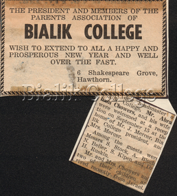
Article (item) - Welcome reception for Chowers family, c. 1963-1964
Newspaper clipping about a welcome reception held for the new headmaster Abraham Chowers and his family, c. 1963. Please contact [email protected] to request access to this record.event, principal, 1960s, shakespeare grove -
Bendigo Historical Society Inc.
Map - KIMBOLTON, No date Visible
Map: Kimbolton, County of Bendigo. Parish plan ( number 172 in Map Cupboard 1)map, bendigo, parish plan, kimbolton -
Whitehorse Historical Society Inc.
Article, Places For Kinder Kids In Jeopardy, 1993
State Government has proposed to merge kindergartens with child care centres.State Government has proposed to merge kindergartens with child care centres.State Government has proposed to merge kindergartens with child care centres.child care, fahey, vikki, benwerrin preschool, burwood east, hickey, sue, john, michael -
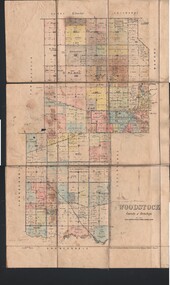 Bendigo Historical Society Inc.
Map - JACK FLYNN COLLECTION: WOODSTOCK, 4/07/1935
Map: Parish of Woodstock, County of Bendigo. Parish plan.By Authority H.J. Green. Govt Printer. Drawn and Reproduced at the Dept of Lands and Survey, Melbourne Victoria. 4.7.35map, bendigo, parish plan, woodstock -
Whitehorse Historical Society Inc.
Article, School move approved
Article in Post, Old Orchard Primary School will move to the former Blackburn Secondary College site in early 1995.Article in Post, Old Orchard Primary School will move to the former Blackburn Secondary College site in early 1995.Article in Post, Old Orchard Primary School will move to the former Blackburn Secondary College site in early 1995.old orchard primary school, blackburn secondary college -
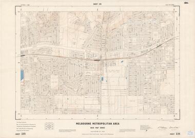 Ringwood and District Historical Society
Map - Melbourne Metropolitan Area Base Map Series, Sheet 235 - Ringwood area, 1960
Map prepared by Dept of Lands and Survey and MMBW from State Aerial Survey June 1957 and Cadastral Survey information August 1960. This sheet comprises parts of Municipalities of Doncaster & Templestowe, Nunawading and Ringwood, and Parishes of Nunawading, Ringwood and Warrandyte.Scale: 400 feet to 1 inch. Contours at 5 feet vertical interval. By Authority: A.C. Brooks, Commonwealth Printer, Melbourne. -
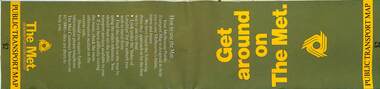 Melbourne Tram Museum
Map, The Met, Public Transport Map - Get around on The Met, c1987
Undated map - c1987 - Neighbourhood and travelcard tickets, has a photo of the front of B2 2004, includes a map of the travelcard neighbourhoods, commuter passes and The Met contact details.Yields information about Melbourne public transport services in c1987Fold out map (36 sections 9 across x 4 deep), "Public Transport Map", coloured of Melbourne's Tram and Bus routes, route numbers, rail lines, detailed for the central part of Melbourne and the outer Metropolitan services.tramways, melbourne, tram services, bus services, railways, maps, travelcard, neighbourhood tickets -
Whitehorse Historical Society Inc.
Article, Stuart wins award, 2/05/1990 12:00:00 AM
Notice from Nunawading Gazette, 2 May 1990.Notice from Nunawading Gazette, 2 May 1990, re Stuart Maybury, winner of the 1990 W.J. Brens scholarship for gardening apprentices.Notice from Nunawading Gazette, 2 May 1990. maybury, stuart, local government -
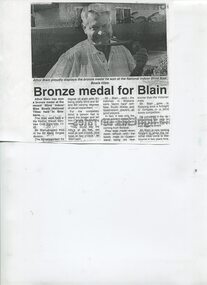 Vision Australia
Article - Text, Bronze medal for Blain
Summary update of Centenary AppealAthol Blain proudly holds his bronze medal won at the recent Blind Indoor Bias Bowls National Titles held in Brisbane. Finishing 3rd in the B2 Mens Singles division, despite the bowling mats in Queensland being six feet shorter than those used in Victoria.Photocopied page with black writing and black and white photographnon-fictionneil maxwell, association for the blind, elizabeth maxwell, athol blain -
 Whitehorse Historical Society Inc.
Article - Documents, Whitehorse Historical Society, Whitehorse Historical Society Newsletters index, 7/2/2018
Collection of printed Newsletters digitised and supplied by Whitehorse Historical SocietyCollection of Whitehorse Historical Society newsletter by month/year. ND8427 - 2003->2008 ND8428 - 2009->2013 ND8249 - 2014->2022 ND8431 - 2023->Collection of printed Newsletters digitised and supplied by Whitehorse Historical Societywhitehorse historical society, mitcham, nunawading, vermont south, forest hill -
Whitehorse Historical Society Inc.
Article, Job advertisements, 1977
Photocopy of a collection of advertisements for positions with municipal councils.Photocopy of a collection of advertisements for positions with municipal councils. Includes position of Assistant Town Clerk with the City of Nunawading.Photocopy of a collection of advertisements for positions with municipal councils.city of nunawading, council staff -
 Bendigo Historical Society Inc.
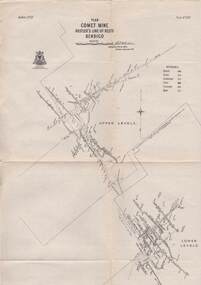
Map - STRUGNELL COLLECTION: HUSTLER'S LINE OF REEFS, BENDIGO, September 1913
Map, Hustler's Line of Reefs, Comet Mine, Bendigo Plan.Plate No.XX1V (24). Map, Bulletin No 33 Signed H.A.Whitelaw Underground survey Office Bendigo September 1913 Drawing shows upper and lower levels and appears to show samples of connecting horizontal shafts with their respective mineral contentsUnderground Survey Office, Bendigo.map, bendigo, comet mine -
 The 5th/6th Battalion Royal Victoria Regiment Historical Collection
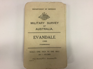
Map, Military Survey of Australia. Evandale (1939) (Tasmania), 1939
Fabric backed colour map, with card cover that folds into a small book. Scale one inch= one mile.military, survey, map, tasmania, ww2, wark vc club -
Stawell Historical Society Inc
Map, Section of Map, Mining, Stawell
Section of Map, Mining, Stawell stawell -
 Whitehorse Historical Society Inc.
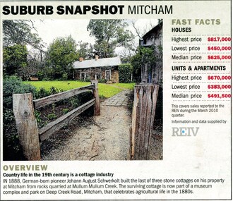
Article, Suburb snapshot Mitcham, 2010
Fast facts about house, unit and property prices in Mitcham, incl. a paragraph and photo of Schwerkolt Cottage.Fast facts about house, unit and property prices in Mitcham, incl. a paragraph and photo of Schwerkolt Cottage.Fast facts about house, unit and property prices in Mitcham, incl. a paragraph and photo of Schwerkolt Cottage.mitcham, schwerkolt, johann august -
 Glen Eira Historical Society
Article - East Caulfield Park
This file contains two items about this Park. An article featuring Caulfield Park and East Caulfield Park, which was developed as the districts principal sporting areas, relating to development and restoration. Includes copies of four photographs relating to the parks featured. One colour photograph of the Park: undated, source unknown. Noted on reverse 'E. Caulf. Reserve Pavilion'.caulfield, caulfield park, east caulfield park, crown reserves, caulfield council, east caulfield park, committee of management, caulfield park committee of management, little harold, lidsey p. mrs., hannan lynette ms., leskie mr., caulfield sub district cricket club, caulfield lacross club, anderson sandy, michelson david, balaclava road, hawthorn road, victorian cricket association, cbc st. kilda, grimwade house, st. aloysius primary school, st. anthony’s primary school, monash university caulfield campus, committees of management, cypress trees, mahogany gym trees, parks and reserves, gardens, parks, sport, sports and recreations, leisure, cultural events, cultural activities, sportsgrounds, sports people, ovals, playing fields, sports establishments, recreations establishments, clubs and associations, associations, organisations, societies, athletic clubs, community groups, pavilions, playground equipment, playgrounds, gardens, barbecues, picnics, tennis courts, lawn bowls, bowls, bowling clubs, schools, educational establishments, trees, plants -
Bendigo Historical Society Inc.
Map - EPPALOCK : COUNTY OF BENDIGO, 1982
Map. Eppalock, County of Bendigo, Axedale, Knowsley, Heathcote, Tooborac, Kyneton, Lancefield, Pyalong, Seymour, Graytown, Toolleen, Colbinabbin, Costerfield, Redesdale, Mia Mia, Nagambie, Department of Interior, Puckapunyal Military Area, Various connecting roads. Shire of McIvor. Updated Dec.1982. (number 40 in map cupboard 1)map, bendigo, eppalock -
Canterbury History Group
Map - Camberwell and Boroondara, Melbourne and Metropolitan Board of Works, c.1905
Copy of Melbourne and Metropolitan Board of Works Plan no. 71 for Camberwell and Boroondaracanterbury, maps, melbourne and metropolitan board of works -
Whitehorse Historical Society Inc.
Map, Township of Norwich, ca 1850
Plan of the Township of Norwich being subdivision of Section III, Parish of Nunawading, County of Bourke, consisting of suburban farms, vineyard sites and town lots, for sale by auction by W. Casey & Co. [c. 1850]. Original in Vale Maps Collection, La Trobe Library.norwich village, vermont, parish of nunawading, vermont south, maps -
Whitehorse Historical Society Inc.
Article, Two-city union is logical, 1986
The review of the Cities of Nunawading and Box Hill seems logical as the links go back more than a century.The review of the Cities of Nunawading and Box Hill seems logical as the links go back more than a century. Chief Executive Les Fell says local government needs greater strength to meet the challenges of the future.The review of the Cities of Nunawading and Box Hill seems logical as the links go back more than a century. local government, city of nunawading, fell, les, amalgamations -
 Glen Eira Historical Society
Article - Howitt Family
Photocopied extract on ‘The Howitt Family of Barragunda’ from ‘Early Pioneer Families of Victoria and Riverina’ includes black photos of family. Handwritten family tree – source unknown. Two handwritten foolscap sheets with extracts from Caulfield Rate Books, 1857-1891 where Howitt is listed as owner of properties, records tenants, addresses, size of property and value. Typewritten notes on the biography of Dr. Godfrey Howitt, outlines qualifications, endowments, interest, membership, no map included – it says Foot Survey Map. Howitt, Alfred William, typed and handwritten notes, references to house. Notes on publications written by Howitts, and the roles they undertook.bakewell, millman william, howitt godfrey dr., howitt john henry, howitt richard, howitt phoebe, mrs. nee godfrey bakwell, howitt william, howitt edward, howitt charles ernest, howitt edith mary, howitt alfred william, burke and wills expedition, king john, ‘rosemont’ kooyong rd, melbourne university, pioneer, botanist, naturalist, squatters, doctors, crotonhurst rd, caulfield, kooyong rd west, balaclava rd west, eyre rd, hume rd, howitt thomas, tantum phoebe, boothby benjamin judge, botham mary, millman william, mcwilliams robert, blake arthur palmer, grice james, spretchley edward, mcnaughton goerge, campbell john a., serle w.h., howitt mary, mickle royal society of victoria, st. mary’s church of england caulfield, stables, slab huts, police magistrate, authors -
 Bendigo Historical Society Inc.
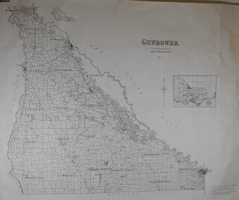
Map - JACK FLYNN COLLECTION: GUNBOWER, 1935
Map: County of Gunbower, map sheet showing the whole of the County of Gunbower and all of the Parishes within.map, gunbower, county, gunbower -
Moorabbin Air Museum
Article (Item) - Photocopy of article called Dual Control Firefly by R Barney
-
University of Melbourne, Burnley Campus Archives
Article, Australian Gardenhistory Society, 2000-2009
Articles by or about past studentsstudents -
Bendigo Historical Society Inc.
Map - BENDIGO AERIAL MAP 2007
Written on bottom of map ' Australian Government Department of Defence photomap Bendigo Australia WGS84. -
 Melbourne Legacy
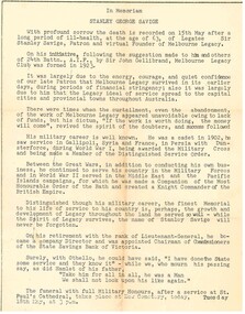
Article, VALE Legatee Stan Savige, 1954
A Vale notice that was published in the Bulletin in 1954 on the death of Legatee Stanley Savige. It is a brief summary of the life of the founder of Legacy written for Legatees who knew him personally. A record of the life and service of Legatee Stan Savige.White A4 paper photocopy from the Bulletin of the Vale notice about Legatee Savige.vale, stan savige