-
 Port Melbourne Historical & Preservation Society
Education kit - Nott Street Primary School Migrant Education Stamp, c.1970
Brown wooden address stamp with black handle and rubber text made for use by the Migrant Education Unit at Nott Street Primary School, Port Melbourne.Migrant Education Nott St Port Melbourne Primary School Number 1457education - primary schools, migrant education, arts and entertainment - music -
Bendigo Historical Society Inc.
Map - CITY OF BENDIGO STREET AND ROAD MAP, 1946
Map: City of Bendigo Street and road map, Incorporating the Borough of Eaglehawk and surrounding Districts. Compiled by W.C Harrymap, bendigo, city streets, bendigo streets -
Bendigo Historical Society Inc.
Map - KOOYOORA, July 23rd 1857
Map: The Township of Kooyoora and suburban allotments in the Parish of Kingower. This plan has been applied to a newer backingmap, township, kooyoora, allotments, parish of kingower -
Bendigo Historical Society Inc.
Map - CORNELLA : COUNTY OF BENDIGO, 18-3-08
Map. Cornella, County of Bendigo, County of Rodney, Colbinabbin, Gobarup, Redcastle, Toolleen, Cornella Creek, Kangaroo Creek. Photo-Lithographed at the Department of Lands and Survey, Melbourne by T.F. McGauran. 18-3-08. Price 1/-. (number 122 in map cupboard 1)T.F. McGauranmap, bendigo, cornella -
Bendigo Historical Society Inc.
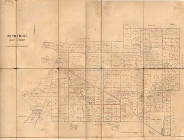
Map - RUNNYMEDE : COUNTY OF BENDIGO, 8-12-13
Map. County of Bendigo, County of Rodney, Burnewang, Elmore, Nolan, Campaspe, Colbinabbin, Burramboot, Corop, Township of Runnymede, Campaspe River, Mount Pleasant Creek. Photo-Lithographed at the Department of Lands and Survey, Melbourne by W.J. Butson.8-12-13. Price 1/-. (number 107 in map cupboard 1)W.J. Butsonmap, bendigo, runnymede -
Stawell Historical Society Inc
Map, Sloanes & Scotchmans Company showing underground drives, c1900
Underground Workings Mapc1900Sloanes & Scotchmans Coy mining, gold, map -
 Whitehorse Historical Society Inc.
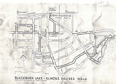
Map, Blackburn Lake - Elmore houses walk, 1/11/1991
Map of Blackburn outlining a walk through the lake.Map of Blackburn outlining a walk through the lake. The route includes four Elmore houses.Map of Blackburn outlining a walk through the lake.maps, blackburn lake sanctuary, the avenue, blackburn, laburnum street, main street, gardenia street, blackburn road, gordon crescent -
 Dandenong/Cranbourne RSL Sub Branch
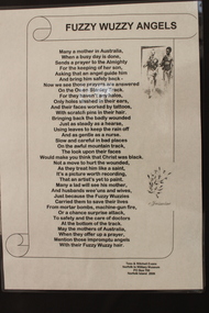
Literary work - Fuzzy Wuzzy Angels
Poem telling the story of the Fuzzy Wuzzy Angels of WWII.Poem. "Fuzzy Wuzzy Angels". -
 Ringwood and District Historical Society
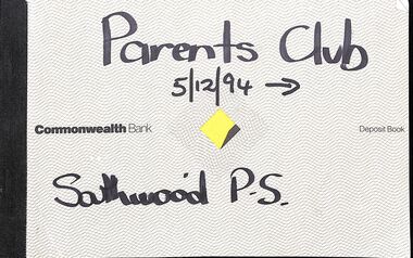
Financial record, Southwood Primary School, Parents Financial Records
Parents Club cheque books, bank statements and receipts, and Mother's Club Account book. -
 Whitehorse Historical Society Inc.
Map, Frank Ainger, 1873
Application by Frank Ainger for land in the Parish of Nunawading on Whitehorse Road near Mitcham Road. Also included are several references from other sources to Frank Ainger.ainger, frank, shire of nunawading, mitcham, land settlement -
Bendigo Historical Society Inc.
Map - PANNOOBAMAWM : COUNTY OF BENDIGO, 1957
Map. Pannoobamawm, County of Bendigo. By Appointment W.M. Houston, Government Printer, Melbourne. Drawn and reproduced at the Department of Lands and Survey, Melbourne. Price 2/-.1957. Turrumberry, Terrick Terrick East, Wanurp,Pannoomilloo, Bamawm, Pannoobamawm. (number 2 in map cupboard 1)W.M. Houston, Government Printermap, bendigo, pannoobamawm -
Bendigo Historical Society Inc.
Map - CITY OF SANDHURST SHEET NO. 5, 18/04/1882
Map: City of sandhurst sheet No. 5. Parish plan ( number 223 in Map Cupboard 1)map, bendigo, parish plan, sandhusrt -
Stawell Historical Society Inc
Map, Shire of Stawell, 1963
Shire of Stawellstawell -
Bendigo Historical Society Inc.
Map - FRED COWIE COLLECTION: AERIAL MAPS OF HEATHCOTE/EPPALOCK, 28-9-60
Map, Heathcote C4, Aerial Survey of Victoria,Photo-map prepared by Department of Crown Lands and Survey from photographs taken in 1960. Copied photographically at the Central Plan Office.Date 28-9-60,C.P.O.Neg.No.21590.Scale 4 inches to 1 mile. Fred Cowie,46 McIvor Rd,Bgo..Central Plan Office.map -
Bendigo Historical Society Inc.
Map - HARCOURT, December 1951
Harcourt, County of Bendigo, Walmer, Castlemaine, Sutton Grange. Mt.Alexander Trig. Station, Barkers Creek, Faraday, Calder Highway, Northern Railway. By Authority J.J.Gourley, Government Printer, Melbourne,Drawn and Reproduced at the Dept. of Lands and Survey, Melbourne, Victoria. December 1951. Price 5/-per sheet. (number 35 in map cupboard 1)J.J.Gourley, Government Printer, Melbourne.map, bendigo, harcourt -
 Bendigo Historical Society Inc.
Map - JACK FLYNN COLLECTION: RUNNYMEDE, June 1946
Map: Parish of Runnymede, County of Rodney. Parish plan.By Authority: J.J. Goourley, Government Printer, Melbourne. Drawn and Reproduced at the Lands and Servey, Melbourne, Victoria. June, 1946.map, rodney, parish plan, runnymede -
Clunes Museum
Financial record - RECEIPT BOOK, BOROUGH OF CLUNES 1833
RECEIPT BOOK. BOROUGH OF CLUNES 1833 VALUATION FOR 1884borough of clunes, financial record -
 Melbourne Tram Museum
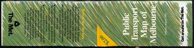
Map, The Met, Public Transport Map of Melbourne - Get around on The Met, 8/1989
Melbourne transport map - dated August 1989 - zone ticket system, has a photo of the front of B2 2004, includes a map of the ticket zones, and The Met contact details.Yields information about Melbourne public transport services in August 1989.Fold out map (36 sections 9 across x 4 deep), "Public Transport Map of Melbourne", coloured of Melbourne's Tram and Bus routes, route numbers, rail lines, detailed for the central part of Melbourne and the outer Metropolitan services.tramways, melbourne, tram services, bus services, railways, maps, zones -
Bendigo Historical Society Inc.
Map - KNOWSLEY : COUNTY OF BENDIGO, 7-11-1941
Map. Knowsley, County of Bendigo, County of Rodney, Weston, Axedale, Eppalock, Knowsley East, Langwornor, Heathcote, Campaspe River, Mt. Ida Creek or Wild Duck Creek, Sandhurst and Heathcote Railway, Kilmore-Heathcote-Bendigo Road. Knowsley Station Ground. Shingle Hut Creek, Forest Creek. By authority H.E. Daw, Government Printer, Melbourne. Drawn and reproduced at the Department of Lands and Survey, Melbourne. 7-11-1941. Price 2/-. (number 103 in map cupboard 1)H.E. Daw, Government Printer, Melbourne.map, bendigo, knowsley -
 Bendigo Historical Society Inc.
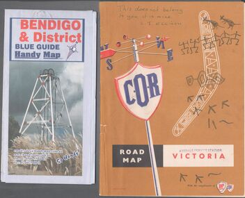
Map - Road maps
BHS CollectionTwo road maps. On, Bendigo & District blue guide handy map the other a road map of Victoria. On the back of the Bendigo map the date October 2000. On the Victoria map the words in pen "This doesn't belong to you, it is mine". L.J. Ellison and a blue stamp of Axedale service station. Aileen and John Ellison Collection.road map, victoria, bendigo -
Port Melbourne Historical & Preservation Society
Financial record - Municipal return, Town of Port Melbourne finances, 1905
Town of Port Melbourne Return to Government Statist: Municipal finances for 1905-06.On rear in blue pencil: 1905/6local government - town of port melbourne, edward c crockford, town clerks -
Stawell Historical Society Inc
Map, Stawell Gold Mine, Perspective View Magdala Decline August 1989, August 1989
Shows Mining Levels Drawn By D. Bosher Stawell Joint Venture Victoria SJVmining, gold -
 Queenscliffe Maritime Museum
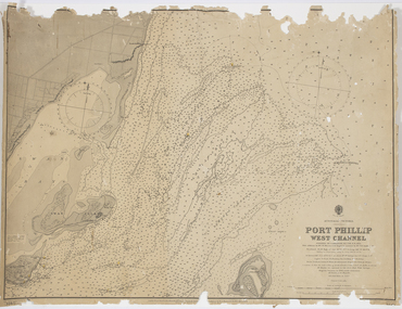
Map - Survey Charts, Port Phillip West Channel
These charts show changes to the depth levels surrounding Queenscliff. Earlier chart does not show the cut which can be seen in the later chart. The creation of the cut and subsequebt dredging of it has changed the shoreline due to shifting sand.Two charts of the Port Phillip West Channel, reference number 309. One was engraved in 1903, the other a new 1935 edition last revised in 1961.Port Phillip West Channelport phillip, queencliff channel, charts, soundings -
 Bendigo Military Museum
Map - Australian Topographical Survey NAGAMBIE SW Sheet, 1 inch:1 Mile, NW portion Plane Table Field sheet 1921, Australian Survey Corps, 1921
This is a coloured reproduction print of an original Plane Table compilation map sheet of Nagambie area 1inch to 1 Mile scale compiled by Sgt Jack Cullen Australian Survey Corps 30 September 1921. Jack was one of the foundation members of the Australian Survey Corps. Of particular interest is the fact that this is a heighted compilation with contouring (required for Military use) as many early maps were purely planimetric. A table on the right hand side details the number of days that it took to produce the compilation. The reverse side of this print is a copy of the Tallarook plane table South East field sheet.Reprinted coloured Image of Australian Topographical Survey NAGAMBIE SW Sheet,1 inch:1 Mile, NW portion hand drawn Plane Table Field sheet. Includes an itemized summary of work, signed by Sgt J Cullen Australian Survey Corps September1921.royal australian survey corps, rasvy, fortuna, army survey regiment, army svy regt, asr -
 Bendigo Military Museum
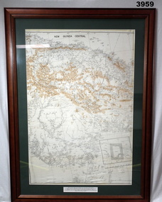
Map - MAP, NEW GUINEA FRAMED, C. 1941 onwards
Map of central section of New Guinea. Black print on white background with mountain ridges in tan. Map is mounted with green border. Brown wooden frame, glass front, white cardboard backing with wire hanging strap on back. Map prepared under the direction of RAAF Headquarters.Printed in black top centre: “NEW GUINEA CENTRAL” Printed on border under map: “These escape maps were carried in the zip pocket of life jackets by fighter pilots in WW2. This map was presented to A.S.R. on 12.7.79 by Councillor Ian McKenzie, Mayor of Eaglehawk, who served as a fighter pilot in 78th SDN in the SW Pacific area during 1943-44.”map, new guinea, central, raaf -
 Marysville & District Historical Society
Map (Item) - Tourist Map, Tourists Resorts' Committee, Tourist's Map of Healesville Marysville and Warburton Districts, 13.10.1925
A tourist map for Healesville, Marysville and Warburton that was produced by the Tourists Resorts' Committee. This map was produced in 1925.A tourist map for Healesville, Marysville and Warburton that was produced by the Tourists Resorts' Committee.Photo Lithographed at the Department of Lands and Survey, Melbourne by W.J. Butson./ 13.10.25healesville, marysville, warburton, victoria, tourists resorts' committee, ben cairn, mount donna buang, the black's spur, the acheron valley, narbethong, launching place, tourist information, tourism, map, tourist map -
Bendigo Historical Society Inc.
Map - LYELL, 4/06/1873
Map: Lyell. Parish plan (number 278 in map cupboard 1)map, bendigo, parish plan, lyell -
 Moorabbin Air Museum
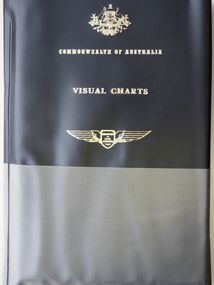
Map (item) - Commonwealth of Australia Visual Charts, VEC (various), Terminal Chart (Various)
-
 Bendigo Military Museum
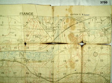
Map - TRENCH MAP WW1, 1918
Areas covered on this map “Corbie, Villers Brettoneux, Hangard, Blangy and Tronville Wood, River Somme”. Item re William Alexander No 502 AIF. Refer Cat No 3746.3 for his service details.Trench map, France, Edition 3B, trenches corrected to 7.7.1918, German trenches in red, British in blue, scale 1:20,000.map, france, trench -
 Northern District School of Nursing. Managed by Bendigo Historical Society Inc.
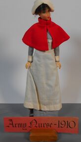
Education kit - Army Nurse 1910 Miniature Doll, Nursing Through the Ages
30cm Miniature Doll dressed in long blue dress with long white apron. Red cape and white veil on head. White cuffs on sleevesName Tagminiature doll, nursing uniform, nursing history