-
 Stawell Historical Society Inc
Photograph, Lady Brooks Kindergarten 1982 -- Coloured
Lady Brooks Kindergarten 1982 Students Groupstawell -
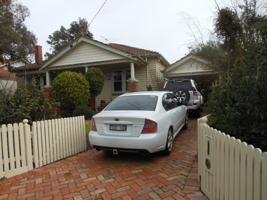 Surrey Hills Historical Society Collection
Photograph - 23 Langford Street, Surrey Hills, The Street Where You Live Project
Photos documenting this address as part of a photographic series undertaken by volunteer photographers during 2013 and 2014 for The Street Where You Live Project. This was organised through the Surrey Hills Neighbourhood Centre and covered the postcode 3127 in the cities of Boroondara and Whitehorse.These photos provide a snapshot of real estate in the suburbs of Mont Albert and Surrey Hills during a period of rapid change with many properties on large blocks demolished to create higher density residential development or renewal of single dwellings. At particular risk were properties not covered by heritage overlays, especially interwar housing and post 1950's housing. -
Lakes Entrance Regional Historical Society (operating as Lakes Entrance History Centre & Museum)
Photograph, Lakes Post Newspaper, 1994
number in album 03580.02Black and white photograph Metung Bowls Club Ladies Triples team, Lyn Whelan, Marj Petty and Wendy Cunningham. Lakes Entrance Victoriabowls club, entertainment -
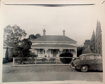
 Whitehorse Historical Society Inc.
Photograph, 93 Central Road, Blackburn - View -3
Colour photograph of the house at 93 Central Road, Blackburn, purchased from William Elliott Wilson, by the Rev. John Flynn of the Australian Inland Mission, for his sister Rosetta Flynn in 1928. Photo shows view of house from street.central road, blackburn, no.93, wilson, william, elliott, flynn, rev. john, rosetta -
![Flooding at Chipperfield's Boathouse [East Kew], 1934](/media/collectors/550653872162f11fb04854aa/items/58cbaad5d0cec425b474bfb1/item-media/58cf6fbdd0cf9f331490feb0/item-fit-380x285.jpg) Kew Historical Society Inc
Kew Historical Society IncPhotograph, Flooding at Chipperfield's Boathouse, 1934
Living with natural processes was frequently a challenge to early European settlers and later residents of what was in the 1850s administered by the Borondara Road Board. This was compounded by the area being bounded on three sides by rivers (Yarra River, Koonung Creek and Gardiner's Creek). In 1849, the historian James Bonwick recorded that "our district [Kew] suffered considerably. Mr Wade speaks of 80 acres, out of 100 acres of his cultivated paddock, covered by water." Newspapers continued to describe major flooding in Kew in 1863, 1869, 1878, 1880, 1889, 1891, 1916 and 1934. While the construction of the Upper Yarra dam in 1957 reduced the levels of flowing downstream, local and riverine floods continue.The Kew Historical Society's pictures and map collections testify to the impact of flooding in the district. They have historical importance in documenting the extent of flooding in the district and its affects on homes, services and recreation. Numerous photographs record flooding throughout the Twentieth Century.Floods in North Kew, 1934. Chipperfield's Boathouse and the adding Moorings was located beside the Yarra River near the corner of Willsmere and Kilby Roads. The flood reached the roof of the Moorings, which can be seen in the photo.floods (kew), floods (kew) 1934, yarra river -
 Kew Historical Society Inc
Photograph, 'Gladstonville', Gladstone Street, 1960
This work forms part of the collection assembled by the historian Dorothy Rogers, that was donated to the Kew Historical Society by her son John Rogers in 2015. The manuscripts, photographs, maps, and documents were sourced by her from both family and local collections or produced as references for her print publications. Many were directly used by Rogers in writing ‘Lovely Old Homes of Kew’ (1961) and 'A History of Kew' (1973), or the numerous articles on local history that she produced for suburban newspapers. Most of the photographs in the collection include detailed annotations in her hand.The Rogers Collection provides a comprehensive insight into the working habits of a historian in the 1960s and 1970s. Together it forms the largest privately-donated collection within the archives of the Kew Historical Society.Small, black and white photo of a double-fronted weatherboard house in Gladstone Street, Kew."Gladstonville. Built 1904 / 7 / Photo 1960 / I was born there 1905"gladstonville, houses - gladstone street -- kew (vic.) -
Bendigo Historical Society Inc.
Map - HEATHCOTE : COUNTY OF BENDIGO, May 1952
Map. Heathcote, County of Bendigo, County of Housie, Knowsley, Knowsley East, Langwornor, Tooborac, Warrowitue, Costerfield, Dargile, Township of Heathcote, Meadows Valley Creek, Wallan and Bendigo Railway, C.R.B. Main Road. By authority J.J. Gourley, Government Printer, Melbourne, Drawn and reproduced at the Department of Lands and Survey, Melbourne. May 1952, Price 2/-. (number 89 in map cupboard 1)J.J. Gourley, Government Printer, Melbourne.map, bendigo, heathcote -
 Eltham District Historical Society Inc
Photograph, Jim Connor, Main Road, Eltham, 14 Jan 2017
Eltham Gateway, Our Lady Help of Christians - Eltham, 866 Main Rioad, ElthamTomorrow's history documented todayeltham, jim connor collection, main road, eltham gateway, henry street, our lady of help christians church -
Port Melbourne Historical & Preservation Society
Photograph - Sketch, selected design for Centenary Bridge, 1930s
Photo by Alison Kelly, from a publication at the PMA archivesColour photograph of page from book at PMA archives, showing sketch of selected design for Centenary Bridgeengineering - bridges, centenary bridge, melbourne harbor trust - port of melbourne authority -
 St Patrick's Old Collegians Association (SPOCA)
Photograph - SPOCA, Annual Dinners
-
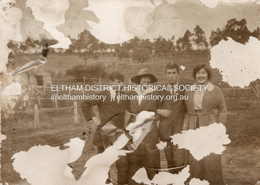 Eltham District Historical Society Inc
Photograph, Unidentified Withers family members outside Southernwood home, Bolton Street, Eltham, n.d
Many items in this collection have suffered from significant water damage and black mouldjohn withers collection, eltham, southernwood -
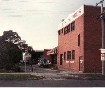 Whitehorse Historical Society Inc.
Photograph, Enterprise Way, 13/06/1986 12:00:00 AM
2 Coloured photos of Enterprise Way - Right-of-way B/N Brittania Street and Mitcham Road. This lane ran between the rear of shops on Whitehorse Road and the Mitcham Primary School (Lower School). Demolition of the school made way for Coles/New World Supermarket and several shops on Whitehorse Road made way for Original Coles Variety Store (facing Whitehorse Road) in foreground.coles variety store -
 Stawell Historical Society Inc
Photograph, Group of Children on Stage -- possibly a Sunday School Concert with Miss Irene May Berndt on the left c1910
Group of Children on Stage (Sunday School Concert ??) c1910 on left is Irene May Bernot later Mrs N. Maloney.stawell entertainment -
 Federation University Historical Collection
Photograph, Site of Sovereign Hill and Ballarat Lodge
The Old Ballarat Travel Inn was located at 613 Main Road. It later Became Ballarat Lodge and Mecure Ballarat.Photograph showing the site of Sovereign Hill in fron to the pine trees, and Elsmore street running along the right. Ballarat Lodge, the brainchild of John Gilbert, can be seen in front of the dam in the centre. The start of Magpie Street can be seen on the left hand side of the photograph.ballarat lodge, john gilbert, sovereign hill, elsmore street, main road, ballarat east, old ballarat travel inn -
Glenelg Shire Council Cultural Collection
Photograph - Photograph - Portland Harbour, n.d
Port of Portland Authority Archivesport of portland archives, construction, portland, harbour, spray wall -
Bialik College
Photograph (Item) - Kinder Farm Visits, c1990s
Approximately 1990s various kinder classes from Bialik attended a farm. Children are showing holding a chicken and feeding sheep. For inquiries or access contact [email protected], jewish school, bialik college, photographs., excursion, kindergarten -
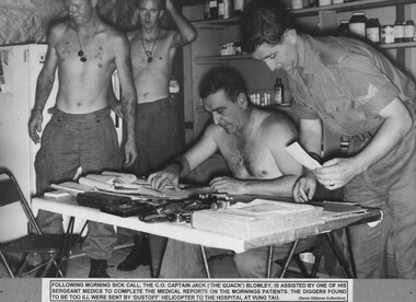 National Vietnam Veterans Museum (NVVM)
Photograph, Morning Sick Call
A black and white photograph - Following morning sick call the Commanding Officer, Capt Jack (The Quack) Bromley, is assisted by one of his Sgt Medics to complete the medical reports on the moning's patients. The diggers found to be too ill were sent by Dustoff Helicopter to the hospital at Vung Tauphotograph, capt jack (the quack) blomley, 2 field ambulance, nui dat, dustoff, vung tau, gibbons collection catalogue, digger, medic -
 Eltham District Historical Society Inc
Photograph, Jim Connor, Avenue of Honour, Main Road, Eltham, 14 Jan 2017
Eltham Gateway, Wingrove Cottage (c.1856), 672 Main Road, Eltham Now a business centre and location of Dwelling on Design, Cameron Construction, My ChiropracticTomorrow's history documented todayeltham, jim connor collection, main road, avenue of honour, eltham gateway, cameron construction, dwelling on design, my chiropractic, wingrove cottage -
University of Melbourne, Burnley Campus Archives
Photograph - Black and white print, 76/6, 1947
Poultry penspoultry pens, e. m. gibson collection -
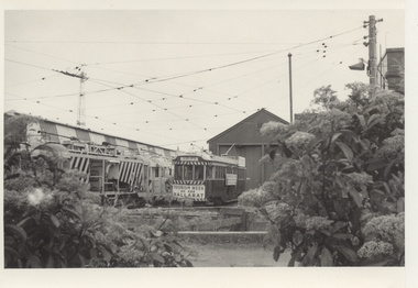 Melbourne Tram Museum
Photograph - Black & White Photograph/s, Chris Phillips, 1971
Black and white photograph of Ballarat 36 at the South Melbourne Tram Depot, 1971. Has Works trams No. 6 and another alongside.trams, tramways, ballarat, south melbourne depot, tourism, tram 36 -
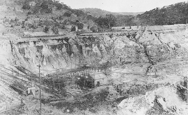 El Dorado Museum Association Inc.
Photograph (item) - Digital Image
Cocks Pioneer Electric Gold & Tin Mine Company was formed in 1899. The company's first power station, located at the eastern end of the valley began operating with its 340 Kilowatt steam-powered generator. By 1909, from 2,500,000 cubic yards worked, reported recovery was 17,284 ounces of gold and 224 tons of tin ore. By 1909, Cocks Pioneer’s power plant had become inadequate and uneconomical. The barge was floated downstream about a mile, but lost time caused the operations to cease. Following testing, a new mine was established by diverting Reid's Creek at a cost of £25,000. Settling dams were built, one of which held 1,935,900 cubic feet. Sold earth banks, built against a wall of stringy bark saplings constructed and laced with vertical props, were built. In 1914, the company was reformed as Cock’s Pioneer Gold and Tin Mines NL, another power station was constructed at the western end of the township, near the junction of Clear and Reid's Creeks. From 6,800,000 cubic yards of material processed, the returns were 64,397 ounces of gold and 855 ton of tin. Cocks Pioneer mine then moved the barge downs stream and continued sluicing. In 1929 Cocks Pioneer Electric Gold and Tin Mining Company ceased operations due to a drop in values. Cock’s Pioneer Gold and Tin Mines NL carried on large-scale hydraulic sluicing operations until 1941. mines, mining, tin, gold, tin mining, gold mining, sluicing, cocks pioneer, el dorado, eldorado -
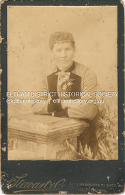 Eltham District Historical Society Inc
Photograph, Stewart & Co, Unidentified Shillinglaw Family Female, c.1889
Stewart & Co operated from 217-219 Bourke St., East from 1877 to 1889 CABINET 1866-1905 The Cabinet photo was introduced in 1866 in answer to a demand for a larger format photograph which could be mounted for a cabinet or on the wall. They were 4.5 inches by 6.5 inches (11.5 x 16.5 cm), more than twice the size of the cdv. They cost about twice as much as a cdv but eventually displaced them. They were not extensively produced until 1880 and had ceased by 1905. Coloured mounts, especially maroon or green, indicate a date between 1880 and 1890. - Frost, Lenore; Dating Family Photos 1850-1920; Valiant Press Pty. Ltd., Berwick, Victoria 1991cabinet photo, marg ball collection, 1877-1889, 1889, female shillinglaw 3, shillinglaw family photo album 3, stewart & co photographers 217 & 219 bourke st east melbourne, unknown -
 Stawell Historical Society Inc
Photograph, Mrs Jodie Grinham nee Cross with her 2 sons
Grinham. Jodie (nee Cross) & 2 Sonsstawell -
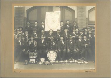 Bendigo Historical Society Inc.
Photograph - EAGLEHAWK FIRE BRIGADE
Black and white photograph of the Eaglehawk fire brigade date unknown. There are 36 men in uniform. Large banner at the back and numerous trophies at the front.eaglehawk, history, fire brigade -
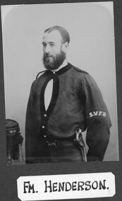 Stawell Historical Society Inc
Photograph, Stawell Fire Brigade's Fireman Henderson 1885 -- Studio Portrait
Portrait. Fm. Henderson. Stawell Fire Brigade 1885stawell -
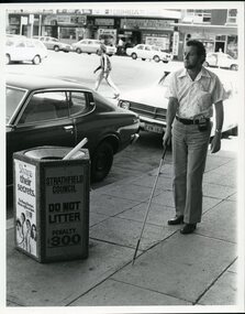 Vision Australia
Photograph - Image, Man using white cane and sonic guide
A bearded man uses a white cane and sonic guide to help him navigate around the streets of Strathfield. The sonic guide consists of a pair of heavy black spectacles with three sensors built into the bridge of the glasses. The glasses are attached by a cable to a control box which is designed to be clipped onto the wearer's belt or clothing. The control box has two switches and a volume setting, and assists the user in determining objects in their path and their distance to them.2 B/W photographs of man using sonic guide and white cane"5156-220" and '5156-224" on back of photographsroyal blind society of nsw, white cane, orientation and mobility -
Glenelg Shire Council Cultural Collection
Photograph - Photograph - Sacked rice in storage, c. 1979
Port of Portland Authority archives.Front: (no inscriptions) Back: (no inscriptions)port of portland archives -
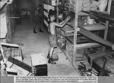 National Vietnam Veterans Museum (NVVM)
Photograph, Stores Check
A black and white photograph of Stores staff in the Quartermasters Store at 1st Australian Field Hospital, Vung Tau, South Vietnam, check and stack stores. The constant use and deterioration of stores required constant vigilence by the stores staff to maintain hospital requirements.photograph, quartermasters store, 1st australian field hospital, vung tau, digger, gibbons collection catalogue -
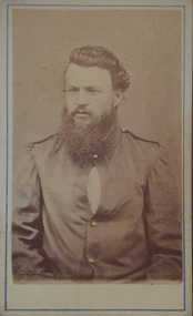 Ballarat Heritage Services
Photograph - Photograph - Black and White, H. Moser, Portrait of a Man in Uniform, circa 1866 - 1887
Photographic portrait of a man in uniform.fullarton, man, uniform, h. moser, creswick, daylesford -
 Kew Historical Society Inc
Photograph, Kew Festival, 1992
The Kew Festival began in 1974. A feature of many festivals were the festival parades in which community groups participated. None of the photographs in the album are named so KHS welcomes viewers to identify participants and or locations.Photograph from an album depicting participants in the 1992 Kew Festivalkew festival - 1992