-
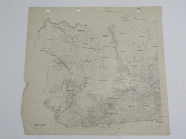
 Whitehorse Historical Society Inc.
Map, Blackburn and Nunawading Map, 1960's?
Map of Blackburn and Nunawading.Map of Blackburn and Nunawading.Map of Blackburn and Nunawading.maps, blackburn, nunawading -
 Kew Historical Society Inc
Plan - Subdivision Plan, Jas R Mathers Son & McMillan, East Kew Tramway Estate, 1915
Pru Sanderson, in her groundbreaking ‘City of Kew Urban Conservation Study : Volume 2 - Development History’ (1988), summarised the periods of urban development and subdivisions of land in Kew. The periods that she identified included 1845-1880, 1880-1893, 1893-1921, 1921-1933, 1933-1943, and Post-War Development. These periods were selected as they represented periods of rapid growth or decline in urban development. An obvious starting point for Sanderson’s groupings involved population growth and the associated economic cycles. These cycles also highlighted urban expansion onto land that was predominantly rural, although in other cases it represented the decline and breakup of large estates. A number of the plans in the Kew Historical Society’s collection can also be found in other collections, such as those of the State Library of Victoria and the Boroondara Library Service. A number are however unique to the collection.The Kew Historical Society collection includes almost 100 subdivision plans pertaining to suburbs of the City of Melbourne. Most of these are of Kew, Kew East or Studley Park, although a smaller number are plans of Camberwell, Deepdene, Balwyn and Hawthorn. It is believed that the majority of the plans were gifted to the Society by persons connected with the real estate firm - J. R. Mathers and McMillan, 136 Cotham Road, Kew. The Plans in the collection are rarely in pristine form, being working plans on which the agent would write notes and record lots sold and the prices of these. The subdivision plans are historically significant examples of the growth of urban Melbourne from the beginning of the 20th Century up until the 1980s. A number of the plans are double-sided and often include a photograph on the reverse. A number of the latter are by noted photographers such as J.E. Barnes.The East Kew Tramway Estate was a subdivision of two separate parcels of land between Adeney Avenue and Normanby Road. The larger section included 54 lots facing Adeney Avenue, Argyle Road, and Campbell, Hunter and Wishart Streets. [Hunter and Wishart Streets were created as part of the subdivision.] A further 17 allotments faced Normanby Road, Hubert and Campbell Streets. [The name of Hubert Street was later to be changed to Cecil Street.] The promotion of the sale referred to the advantages of living between two tram routes, in High Street and Cotham Road. On the plan, quaintly drawn trams mark these routes. Also on the plan is the route of part of the Outer Circle [Railway] Line.east kew tramway estate, subdivision plans - east kew -
Port Melbourne Historical & Preservation Society
Plan - Port Melbourne Yacht Club, John Adam, Architect, 1960s
Plans for Port Melbourne Yacht Club new dinghy building 1962. .01 Storage layouts - sketch plan .02 Plan of new dinghy building .03 Location and pile plan .04 Working drawing - site elevations .05 Working drawing - plan view sport - yachting, built environment - recreational facilities -
 Whitehorse Historical Society Inc.
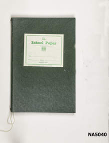
Education kit - School papers, School paper cover & paper
School paper cover with school papers 1939 inside.Green cardboard cover with label on the cover. The paper is held in place with strings."The School Paper" -
 Ringwood and District Historical Society
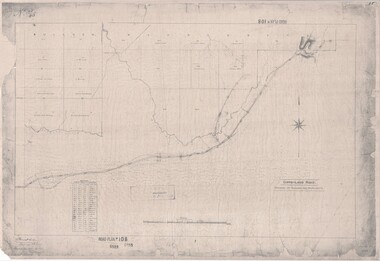
Map, Road Plan 108 - Gipps-land Road, Parishes of Bulleen and Warrandyte (Ringwood, Victoria) - 1855
Surveyor's map of the part of the main road from Melbourne to Gippsland following "Barker's Track" south of Mullum Mullum or Deep Creek. Map references include Roman numerals marking distances measured in Links between trees at turns in the road.Submitted to the Surveyor General (Signed) July 2nd 1855. -
 Federation University Historical Collection
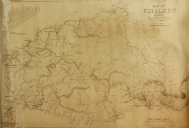
Map, Plan showing Locality of Reported Gold Find District of Tavula, 1935
Map with coloured shading on paper backed onto linen showing Crown Indian Settlement, Tovatova, Koro, Devotamap, devota, koro, crown indian settlemt, tovatova, tavua -
 Whitehorse Historical Society Inc.
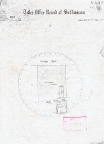
Map, Titles Office Record of Subdivision
Titles Office Record of Subdivisionclarkes road, blackburn, whitehorse road -
Port Melbourne Historical & Preservation Society
Plan - Fence, J W Martin?, 1874
Design for unidentified fence, 1874.Signed J.W. Martin and E. Clarkengineering - fences, edward clark, town clerks, j w martin -
Glenelg Shire Council Cultural Collection
Plan - Ship Plan / Mould, n.d
Wooden pattern for mould for boat fitting. 'Waisted' cylinder, circular knob attached to centre of each end. Painted orange. -
University of Melbourne, Burnley Campus Archives
Plan, Alterations and Refurbishment of the Centen nial Display Building, 1990
Specification of workmanship and materials to be used in the construction of: Alterations and Refurbishment of the Centennial Display Building at Victorian College of Agriculture and Horticulture, Burnley for VCAH by Urban Spaces Pty. Ltd., Architects. Includes Plans and Elevations, and Presentation Drawings. Provenance Geoff C(?) 19.08.91. vcah, centennial -
Hume City Civic Collection
Education kit - Cuisenaire set
Cuisenaire rods are mathematical aids introduced into Victorian schools in the mid 1960s. They aimed to give students different ways to explore mathematics and learn the basic concepts of addition, subtraction, multiplication and division as well as fractions and decimals.A small grey cuisenaire box with a lid and instruction sheet of rods. The details of the contents are written in yellow on the lid. mathematics, schools, cuisenaire rods, teaching apparatus -
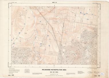 Ringwood and District Historical Society
Map - Melbourne Metropolitan Area Base Map Series, Sheet 215 - Ringwood area, 1967
Map prepared by Dept of Lands and Survey and MMBW from State Aerial Survey June 1957 and Cadastral Survey information July 1967. This sheet comprises parts of Municipalities of Doncaster & Templestowe, Nunawading and Ringwood, and Parishes of Nunawading and Warrandyte.Scale: 400 feet to 1 inch. Contours at 5 feet vertical interval. By Authority: A.C. Brooks, Commonwealth Printer, Melbourne. -
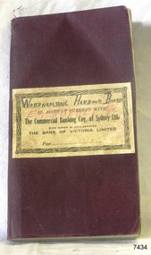 Flagstaff Hill Maritime Museum and Village
Financial record - Bank Transaction Book, Commercial Banking Company of Sydney Limited, before 1931
The financial account book was used by the Warrnambool Harbour Board for its Emergency Account. It records transactions made with The Warrnambool branch of the Commercial Banking Company of Sydney Limited during the year 1931. The Secretary of the Warrnambool Harbour Board would have used this book in 1931. James Menzies, Pilot arid Harbour Master from 1929, was appointed as Acting Secretary for the Board in 1932 and held this office until the Board ceased in 1936. Warrnambool’s CBC Manager during this time was L E Whitney; he was Manager from 1924 to 1939. The Commercial Banking Company of Sydney Limited opened in 1893. On January 1, 1927 the CBC amalgamated with the Bank of Victoria. In 1981 the CBC merged with the National Bank of Australasia Limited and on January 1, 1983 the bank started using the abbreviated name of the National Australia Bank (NAB). Warrnambool Harbour Board- The Warrnambool Harbour Board was constituted by Order of Council on May 29, 1928, under the Harbour Board’s Act of 1927, taking over from the Ports and Harbours Branch of the Public Works Department of Victoria. The Board was then the only body with power to manage and control the whole Port, including shipping, facilities upkeep and improvements of the port. The work it carried out involved dredging, building of port facilities and drafting of port regulations, and collecting taxes, tolls, rates and charges. The Board was officially dissolved on June 30, 1936, at which time the Public Works Department again had control. The Warrnambool Harbour Board had rented out the Lighthouse Keeper’s Quarters from the 1920s until 1936, when the Board closed down. However, rentals continued with other currently unknown landlords until Flagstaff Hill Maritime Village opened in 1975 and began renovating the Cottage, in stages. Text on the fly page of the book is as follows – “The Commercial Banking Company of Sydney Limited with which is Amalgamated THE BANK OF VICTORIA LIMITED. Head Office – SYDNEY. Melbourne Office: 237 COLLINS STREET. BANKING Business of every description transacted. BRANCHES throughout VICTORIA, NEW SOUTH WALES and QUEENSLAND, and ADELAIDE BRANCH, SOUTH AUSTRALIA, and AGENCIES throughout AUSTRALASIA and NEW ZEALAND on which DRAFTS AND LETTERS OF CREDIT Are issued and also on LONDON BRANCH and AGENCIES in all the PRINCIPAL CITIES of the world. Telegraphic Remittances made, Bills Negotiated or Forwarded for Collection, Advances made, Deposits received, Current Accounts kept. FURTHER PARTICULARS ON APPLICATON. “ This bank transaction book is of local and state significance for its association with the Port of Warrnambool and the Warrnambool Harbour Board. The Warrnambool Harbour Board was the only board formed under the 1927 Harbour Boards Acts, even though other Victorian ports were eligible. The book is also significant as an example of bank records used by Australian and overseas branches of the Commercial Banking Company of Sydney Limited, and the Bank of Victoria Limited.Maroon coloured rectangular book with textured cover and cream coloured label attached. Label has a printed title on book plus hand written titles added in black and red. The corners of the book are rounded. The white pages have pre-printed text and lines. The book was used for transactions between the Warrnambool Harbour Board’s Emergency Account and the Commercial Banking Company of Sydney Limited during the year 1931.Handwritten in black “WARRNAMBOOL HARBOUR BOARD “, “EMERGENCY A/C” Printed in black “IN ACCOUNT CURRENT WITH”, “The Commercial Banking Coy. Of Sydney Ltd.”, “WITH WHICH IS AMALGAMATED”, “THE BANK OF VICTORIA LIMITED”, “Page …”warrnambool, shipwrecked-coast, flagstaff-hill, flagstaff-hill-maritime-museum, maritime-museum, shipwreck-coast, flagstaff-hill-maritime-village, warrnambool harbour board, financial account, emergency account, financial record, commercial banking company of sydney limited, 1931 bank book, bank of victoria limited, transaction book, financial management, stationery, deposit book, public works department, ports and harbours, commercial banking company of sydney ltd., james menzies, harbour master, l e whitney, cbc manager warrnambool, harbour board act, port of warrnambool, warrnambool harbour, lady bay, harbour pilot -
Stawell Historical Society Inc
Map, Land Map of Victoria 1898, Supplement to "The Leader", 1898
Land Map of Victoria 1898, Supplement to "The Leader"stawell -
Federation University Historical Collection
Plan, Michael Adermann
A number of photos of Michael Adermannmichael adermann -
 Warrnambool and District Historical Society Inc.
Map - Maps, Soldiers Settlement WW2, Circa 1950
The soldiers' settlement scheme operated after the first and second world wars in an effort to more closely settle the land and also give opportunities to returned soldiers. Crown land and other larger estates were acquired for the purpose. Most of these maps relate to the area north of Warrnambool where many of the subdivisions were parts of larger estates.These maps pertaining to the Soldiers' Settlement program, relate to an interesting part of Australian and local history. As such they have historic and social interest and significance.A collection of 25 paper maps which relate to to the soldiers settlement post World War 2. Some have details of the people allocated the land and some smaller maps have the printed details of the applicants requirements.Text is black on white paper which in some cases is quite aged. The maps are as follows: .1 Narrapumelap Estate ( Ripon & Hampden) .2 Narrapumelap Estate Part 2 (Villers & Ripon) .3 Narrapumelap Estate Part 3 ( Villiers & Ripon) .4 Burrumbeet Estate ( Ripon) .5 ' Berrambool' Estate 9 Hampden & Villiers) .6 ' Hopkins Hill' Estate Villiers 4011 acres .7 Caramut North No 2 Estate ( Villiers ) .8 ' Morpor' Estate ( Villiers) 4172 acres .9 ' Morgiana' Estate ( Normandy) 3453 acres .10 ' Chatsworth House' ( Villiers) 9341 Acres .11 ' East Elwood' Estate Villiers 2407 acres .12 Grey's Estate ( Mornington) 1151acres .13 ' Rowes Estate' ( Buln Buln Gippsland 733 acres .14 'Tarrone' Estate No 2 Part map .15 'Chaldon Meade' Estate (Bourke) Bulla 517 acres .16 ' Terranallum South' Estate Hampden 3757 acres .17 ' Brung Brungle' Estate Dundas 695 .18 ' Armidale ' Estate ( Dundas)2108 acres .19 ' Moyne Falls' Estate ( Villiers) 627 acres .20' Yulong' Estate 9 Lowan 6321 acres .21 Murray Valley Irrigation District 9 Moira)113 acres .22 Murray Valley Irrigation District 103 acres .23 ' Mount Fyans' Estate ( Hampden) .24 ' Barwidgee ' Estate ( Villiers) 4277 acres .25 'Pine Hills' Estate 2nd portion ( Lowan) 6190 acres narrapumelap, berrambool, hopkins hill, caramut north, morpor, chatsworth house, east elwood, terrinallum, moyne falls, tarrone, caramut soldiers settlers, burrumbeet, morgiana, grey's estate mornington, chaldon meade, brung brungle -
Port Melbourne Historical & Preservation Society
Map - Proposed cut and Ferguson Dock, Port Melbourne, Jul 2008
Map of proposed cut and Ferguson Dock which would have run from near the location of Princes Pier to swinging basin in Yarra River. Varied information on back - weather and some local informationpiers and wharves - miscellaneous, melbourne harbor trust - port of melbourne authority, mr ferguson, fishermans bend, ferguson dock -
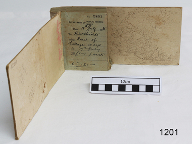 Flagstaff Hill Maritime Museum and Village
Financial record - Receipt Book, Department of Works and Mines Victoria, July 1936 (first record)
Establishment and Functions Prior to 1860, the Chief Secretary's Department had been responsible for the administration of the gold fields and associated mining activities. In November 1860 a Commissioner of Mines was appointed and a Department was established under his administration. For the period November 1861 to June 1863, the Postmaster General was responsible for the Mining Department. A Minister of Mines was again appointed in 1863. Responsibilities of the Department of Mines were: 1. Regulation of mining and related public works activities through the issue of miners rights, business and residence licences, mining leases, mineral and other prospecting licences 2. Superintendence of the activities of mining surveyors, registrars, wardens and Mining Boards. 3. Investigation of the state's geological structure, mineral wealth and underground water resources 4. Development of the mining industry 5. Supervision of the safe working of mines, machinery and quarries including checking the credential of mine managers, inspectors and operators 6. Regulation of the disposal of sludge and other waste products 7. Administration of the Victorian Mining Accident Relief Fund. Arising from its initial responsibility for the supply of water on the gold fields, the Department became responsible for rural water supply from the mid 1860s. Statutory responsibility for rural water works during this period rested with the Board of Land and Works. In 1865 the Waterworks Act gave the Board power to construct waterworks, purchase land, levy charges and lease or sell works, while the Public Loans Act 1865 empowered it to provide loans to local water trusts for waterworks. The actual administration of these statutory provisions was undertaken by the Victorian Water Supply Department which operated from 1865 to 1889 as a sub-department of the Department of Mines, from 1889 as a department in its own right, and from 1895 to 1909 as a sub-department of the Department of Mines and Water Supply. For a brief period from 1891 to 1893 the Department of Mines was also responsible for forests and, until 1880, for the Schools of Mines subsequently transferred to the Education Department. In 1895 the Department of Mines and the Victorian Water Supply Department were amalgamated to form the Department of Mines and Water Supply. A snapshot into social history around the 1930s when the Department of works and the Mines Departments were still linkedReceipt Book for the Department of Works; Mines. Receipt No 2801 - 3000. 1st receipt Number 2801, "18th July 1936, for Rent of Cottage: 14 days for 2 pounds, 2 shillings. The inscription on the back is signed by J F Condau in 13-3-33Printed on spine "GENERAL RECEIPTS / 15 / 2801 / TO 3000" Printed on each receipt 'DEPARTMENT OF / PUBLIC WORKS. / MINES." Fill in using ink pen "(DATE) 18th July 1936 / (TO) - - - shields' / BEING) Rent of / Cottage: 14 days / (TO) 17th July / @ (symbol for pound) 1-1. p. week / . (symbol for pound) 2:2:-"Inside cover there is some red pencil writing, words and figures unreadable. Handwritten on back cover "Numbers checked / and found corredt / J S Coudou (?) / 13-3-33" One some receipts "Wharfage / S.S. Koonara"flagstaff hill, warrnambool, shipwrecked coast, flagstaff hill maritime museum, maritime museum, shipwreck coast, flagstaff hill maritime village, great ocean road, department of works: mines, receipt book, rent 1936, imperial currency, living costs 1936, department of works, department of mines, j f condou, 1933, 13-3-33 -
Port Melbourne Historical & Preservation Society
Plan - Reclamation Fishermans Bend with material dredged from Coode Canal, Melbourne Harbor Trust, 1940
One of two A3 photocopies from MHTC plans of proposals for reclaiming Fishermans (sic) Bend with materials dredged from widening of Coode Canal, 1940 (Second copy missing April 2019)Pencil notations re Rotten Row etc.fishermans bend, engineering - canals and drainage, coode canal, melbourne harbor trust - port of melbourne authority -
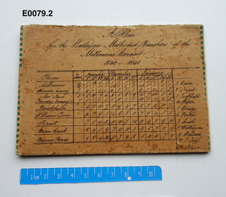 Uniting Church Archives - Synod of Victoria
Plan - Circuit plan, A Plan for the Wesleyan Methodist Preachers of the Melbourne Circuit 1840 - 1841
Wesleyan Methodist Preachers: Orton, Hurst, Tuckfield, Witton, Dredge, Parker, Smith, Wilkinson, Willard, Topp, Stone.Tan coloured card with handwritten title and table which gives the places, dates and Preacher's names in black ink copperplate writing.wesleyan methodist melbourne circuit -
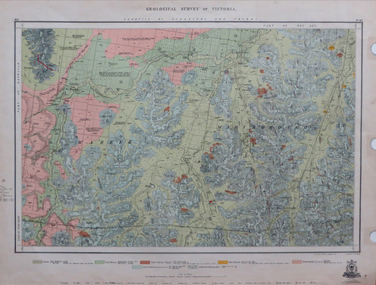 Federation University Historical Collection
Map, Geological Survey of Victoria, 1913
Printed colour map on papervictoria, geological survey of victoria, gladstone, talbot -
Stawell Historical Society Inc
Map, Plan Shewing Auriferous Deposits and Reefs (Map of Water Races), c1878
Plan Shewing Auriferous Deposits and Reefs (Map of Water Races)stawell, water -
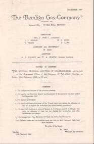 Bendigo Historical Society Inc.
Financial record - Lydia Chancellor collection: Bendigo Gas Company and The Colonial Gas Association Limited
The Bendigo Gas Company notice of annual general meeting of shareholders for the years 1947 to 1952. The meeting to be held at the company registered office at 49 Pall Mall, Bendigo. Directors: Rex F. Hyett (Chairman), J.S. Wilson, H.N. Butt, S. Proud, F. Levy. Manager and secretary W. Pain. Also, The Colonial Gas Association Limited notice of annual meeting for the years from 1949 to 1953 to be held at 360 Collins Street, Melbourne. Directors: C.F. Broadhead (Chairman and managing director), James M MacFarlane, Robert Weir, Gerald L. Patterson.bendigo gas comany, the colonial gas association, shareholders -
 Federation University Historical Collection
Plan, Tanjil Sheet 2, not dated
Printed plan on paper backed onto linen tanjil -
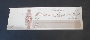 Bendigo Historical Society Inc.
Financial record - Abbott Collection: blank check
One blank check and stub. The check is from the Australian & European Bank Limited.financial record, the australian & european bank -
 Bendigo Military Museum
Plan - MAP, TOURIST, L Joly, A Maunier, WWI
The map belonged to Jack Grinton No 1043 38th Batt AIF. At Wars end extensive leave was granted, Jack journeyed to Paris, Nice, Monte Carlo taking many photos. Part of the Grinton collection which included hundreds of negatives and developed photos that he took during the War. Refer Cat No 1280 for service details. Refer 1317P, 1320P.Map of Paris. Red cardboard or paper hardcover, new edition guide of metropolitan Paris (ministries, tramways, monuments), Index in front, folded paper map attached to back cover. "Plan commode de Paris avec l'itineraire des autobus & tramways metropolitan"documents-maps, french -
 Eltham District Historical Society Inc
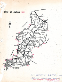
Map, Shire of Eltham (boundaries), 1991
Key to a collection of 35 photos taken by Doug Orford at 35 specific locations along the exact boundary of the then Shire of Eltham. -
Stawell Historical Society Inc
Map, Stawell Gold Mine, SGM Mineralized System Longitudinal Projection showing Diamond Drilling Holes 2007, June 2007
Section of Big Hill showing Diamond Drill holes through Magdala, Magdala North and Golden Gift Ore bodies to 2000m levelLegend of Mine workings numbered. 1980's mining, gold, map -
Moorabbin Air Museum
Essay (item) - Schneider Trophy History, Technical Aspects of the Schneider Trophy and the world speed record for seaplanes
Schneider Trophy -
Moorabbin Air Museum
Map (item) - Silk Map Holland Belgium France Germany Switzerland Sheet C and D