-
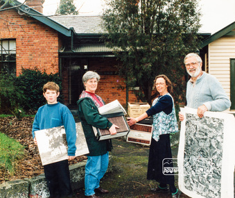
 St Patrick's Old Collegians Association (SPOCA)
Photograph - SPOCA, Annual Dinners
-
 Canterbury History Group
Photograph - Henry M. Smith Thrifty Link Hardware, Jan Pigot, 1989
Black and white photograph of the interior of the hardware shop of Henry Smith looking towards the front door, taken in 1895 by Jan Pigot.canterbury, canterbury road, henry m. smith, thrifty link hardware, tools, hardware stores -
Canterbury History Group
Photograph - Street view of shops around No. 185 Canterbury Road, Jan Pigot, 1994
Coloured photograph of the street view of shops around No. 185 Canterbury Roadcanterbury, canterbury road, shops -
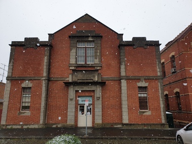
 Eltham District Historical Society Inc
Photograph, Eltham Local History Centre, former Police Residence, 728 Main Road, Eltham, 1998
Members of the Eltham District Historical Society transfer collection items from storage into their new home. Previously occupied by the Parks and Environment Department of Nillumbik Shire Council (L-R: Mark Gillham, Margaret Ball Vice President, Sue Law Immediate Past President, Harry Gilham President) Nillumbik Shire Council Commissioner Vin Heffernan (1996-97) worked with Harry Gilham to obtain use of the former Eltham Shire Parks and Gardens office at 728 Main Road for use by the Society. Harry as a younger man had played in the scrum for Heidelberg Football Club along with Vin's brother who was on the wing. Apparently Heffernan was able to access $30K to spend on the site to fix it up for occupation.Colour photographeltham district historical society, harry gilham, margaret ball, mark gilham, sue law, local history centre, 728 main road, activities, eltham, justice precinct, police residence -
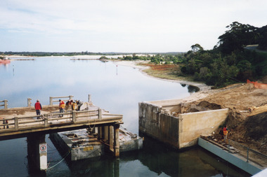 Lakes Entrance Regional Historical Society (operating as Lakes Entrance History Centre & Museum)
Photograph, 2000
Date made May 2000Colour photograph showing the activity during the deconstruction of the old North Arm bridge showing cranes lifting handrails, circular saw cutting concrete bridge decking, and top of piers removed. Scene indicates how the bridge was constructed in 1917. Lakes Entrance Victoriabridges, waterways, boats and boating -
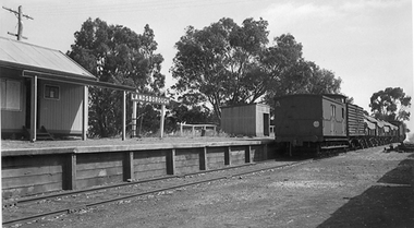 Stawell Historical Society Inc
Photograph, T Murray, Landsborough Railway Station with goods train 1953, 16/12/1953
1953 - Two photographs -
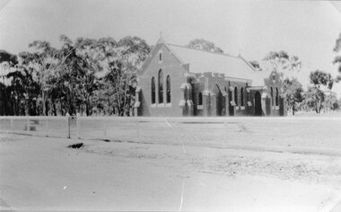 Stawell Historical Society Inc
Photograph, Roman Catholic Church in Glenorchy c1930
Glenorchy Roman Catholic Church c1930stawell religion -
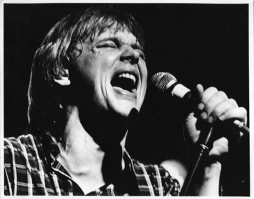 Vision Australia
Photograph - Image, John Farnham on stage
John Farnham singing on stage, possibly for inclusion in the 1986 Carols by Candlelight program.B/W photograph of John FarnhamJohn Farnhamcarols by candlelight, john farnham -
 Federation University Historical Collection
Photograph, Clare Gervasoni, Snow Falling by the Former Ballarat School of Mines Museum Building, 2020, 25/09/2020
This footage was taken during lockdowns during the Covid19 pandemic.A photograph looking towards the Administration Building showing snow falling at the former Ballarat School of Mines Museum Building.snow, ballarat school of mines, smb campus, covid19, former ballarat school of mines museum, former wesley church -
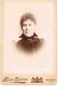 Bendigo Historical Society Inc.
Photograph - UNKNOWN FAMILY COLLECTION: PHOTOGRAPH, Circa. 1890
Photograph - Black and white. Portrait of a woman, from shoulders upward, wearing a high neck, velvet type material, puffed sleeves. She has tight curly hair.Alan Spicer, Bendigo.person, individual, female portrait, photograph. portrait of a woman. unknown family collection. -
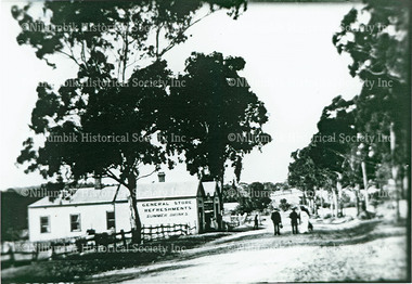 Nillumbik Historical Society Incorporated
Photograph - Black & white photograph, General Store Main Street Eltham
-
 Eltham District Historical Society Inc
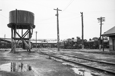
Photograph, George Coop, Ararat Locomotive Shed, c.1971
Digital TIFF file Scan of 35mm Ilford FP3 black and white negative transparencygeorge coop collection, ararat locomotive shed, j-539, j-class steam locomotive (vulcan foundry), k-177, k-class steam locomotive (vr newport workshops), t-335, t-class diesel electric locomotive. -
 Bendigo Historical Society Inc.
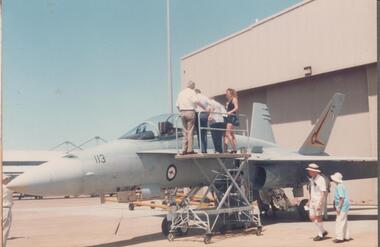
Photograph - RAAF RADAR REUNION COLLECTION: PHOTOGRAPH OF A MILITARY JET
Coloured photograph of a military jet, with five people on a platform looking into the cockpit, two other people walking by and two more standing under.military, airforce, raaf radar -
 Surrey Hills Historical Society Collection
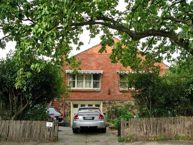
Photograph - 10 Balmoral Crescent, Surrey Hills, The Street Where You Live Project
Photos documenting this address as part of a photographic series undertaken by volunteer photographers during 2013 and 2014 for The Street Where You Live Project. This was organised through the Surrey Hills Neighbourhood Centre and covered the postcode 3127 in the cities of Boroondara and Whitehorse.These photos provide a snapshot of real estate in the suburbs of Mont Albert and Surrey Hills during a period of rapid change with many properties on large blocks demolished to create higher density residential development or renewal of single dwellings. At particular risk were properties not covered by heritage overlays, especially interwar housing and post 1950's housing. -
 Whitehorse Historical Society Inc.
Photograph, Orchard at Blackburn
Black and white photograph of workers on Pearce family orchard on site of present Blackburn High School. Photo taken by photographer from Herald Sun who came every year to photograph the cherry blossom.pearce, ronald, harry, edward h., blackburn high school, orchard, herald sun -
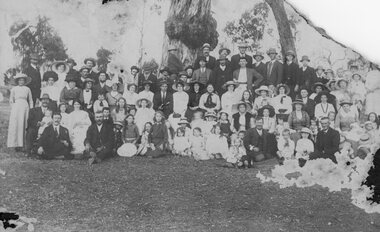 Stawell Historical Society Inc
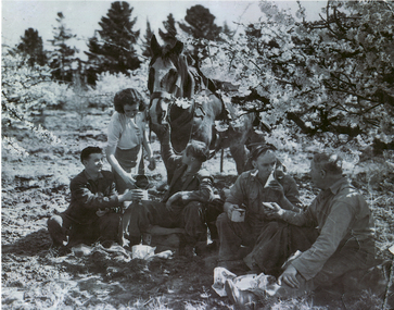
Photograph, Large Picnic Group at Kanya 1916
Large Picnic Group at Kanya 1916stawell -
 Eltham District Historical Society Inc
Photograph - Aerial Photograph, Landata, Eltham; Crown Allotment 15, Section 5, Parish of Nillumbik (Stokes Orchard Estate), Dec. 1945
Centred on present day Diosma Rd, Stokes Pl, Nyora Rd and Eucalyptus Rd Historic Aerial Imagery Source: Landata.vic.gov.au Aerial Photo Details: Project No :5 Project : MELBOURNE AND METROPOLITAN AREA PROJECT Run : 36 Frame : 60546 Date : 12/1945 Film Type : B/W Camera : EAG4 Flying Height : 10200 Scale : 6000 Film Number : 195 GDA2020 : 37°42'47"S, 145°09'56"E MGA2020 : 338306, 5824438 (55) Melways : 22 C4 (ed. 42) A History of the Development of Crown Allotment 15, Section 5, Parish of Nillumbik – Stokes Orchard Crown Allotment 15, Section 5, Parish of Nillumbik (CA15) is a square allotment of 158 acres or approximately a quarter of a square mile. It lies just beyond the eastern end of Pitt Street, south of Nyora Road to the northern end of Eucalyptus Road and extends east from Eucalyptus Road to Reynolds Road. The topography of CA15 is generally steep, sloping up to a hill near the centre of the land, the ridgeline passing through the properties along the southern side of Diosma Road. Eucalyptus Road is a straight north-south road with its northern end at the north west corner of CA15. Until the end of the 1970s this road was an un-named Government Road and was largely not open to traffic. With residential development in the 1970s the road was constructed, and the council allocated the name obviously in recognition of the predominant species of the local bushland. CA15 was purchased from the Crown by George D’Arley Boursiquot, a prominent Melbourne printer, on 28th October 1852. On November 23, 1922, former Member for Gippsland and Melbourne Real Estate Agent, Hubert Patrick Keogh purchased the allotment then sold it March 13, 1925, to local farmer, Robert David Taylor, a former Shire of Eltham Councillor (1911-1920) and Shire President (1919). Taylor had extensive land holdings stretching west towards Bible Street and Main Road. The Taylor home was situated at the top of the hill in Bible Street at present day 82 Bible Street. At the time of Taylor’s purchase in 1925, CA15 was subdivided into 48 lots that could be described as small rural properties or large residential lots. A typical lot size was one hectare or 2.5 acres. The subdivision created two roads, Nyora Road, and Diosma Road, each following an irregular alignment between Eucalyptus and Reynolds Roads. However, the lots were not sold off separately nor were the roads constructed. The land effectively remained as one parcel for many further years. Robert David Taylor died November 30, 1934, and probate was granted to his son of the same name, Robert David Taylor of Bible Street, Salesman and William McLelland Vance Taylor of 73 Emmeline Street, Northcote, Clerk, with the transfer of the land into their names on July 8, 1935. Frank Stokes worked as a qualified accountant at Kennons leather factory in Burnley, while living at 1 Thomas Street, Mitcham. He suffered from migraines and wanted to return to working the land (he had previously worked on farms and orchards since coming to Australia from England in 1926, both in WA and Vic.). He first travelled to the district by train in July 1942 to find land with the intention to establish an orchard. By chance he met Arthur Bird of Bird Orchard (bounded by Pitt Street, Eucalyptus Road, and Wattle Grove) and they got talking over their common interest. Arthur put Frank up for the night and pointed out the land, 158 acres- part of the Taylor Estate- £900, Crown Allotment 15, Section 5, Parish of Nillumbik (CA15) somewhat diagonally opposite Bird Orchard. Stokes applied through the Riverina Agency to purchase the land who in turn applied for permission from Canberra to sell as there was a new government regulation introduced during the Second World War banning land sales except for immediate production. Stokes obtained a loan on his Mitcham house of £600 @ 5% and paid £450 deposit with quarterly payments of £15 spread over 5 years. Stokes was assisted and advised by Arthur Bird who farmed the neighbouring orchard. In early 1943 Stokes took possession and would catch the train out to Eltham on Fridays after work and began building a hut on the corner of Nyora Road and the Government Road (Eucalyptus Road) for shelter and to lock up tools. He established an orchard on the central western part of the land through the centre of which ran a natural waterway (part of the present-day linear park) and was able to pay a neighbour (Hawkins) to help with clearing and fencing 25 acres, and with a horse and single furrowed plough, planted approximately 2,500 fruit trees - cherries, peaches, plums, almonds, pears, apricots and lemons as well as a few apples and oranges; a massive task. Aerial photographs from the 1940s through to the 1990s clearly show the orchard with most of the larger CA15 site remaining as natural bushland. A huge problem was hares and rabbits eating all the new buds off the tiny trees. As well as laying poison he painted the trees with a mixture of cow manure and lime, often working by moonlight. Procurement of wire and wire netting was difficult because of the war but after much effort he obtained a permit from the Agricultural Department for supplies in March 1944. In February 1945 Stokes applied for a permit to build a “packing shed” as no house building was allowed. It was to be 33 feet x 21 feet and cost £312. It was constructed mostly from second-hand materials, which were hard to obtain, especially iron for roofing. Stokes finished work at Kennons on October 31, 1945, and in March 1946 he sold the family home at Mitcham for £1,230 plus £170 for furniture. On May 15, 1946, title to the CA15 property was issued to Frank Howard Alfred Stokes, Orchardist and Gladys Ethel Stokes, Married Woman, both of Pitt Street, Eltham. The family of five then moved into the very unfinished “packing shed” at Eltham, which was a struggle to weatherproof. Eventually rooms were divided off and lined with hessian bags and whitewashed. Their income was firewood (cut and sold), selling rockery stones and cut Sweet Bursaria. (It was discovered during the 1940s that Sweet Bursaria contained the sunscreen compound Aesculin. The RAAF utilised this compound from Sweet Bursaria during WW2 for pilots and gunners.) The orchard’s first fruit sale was a half-case of Le Vanq peaches in December 1947 for the price of 8 shillings. In 1956 plans for house were drawn and Glen Iris bricks purchased (1956 Olympic Rings variant). The building of the house commenced in 1957 - 12 feet of original packing shed was removed – and was completed in 1959. Water was connected from newly built pressure storage on the property at the end of 1959 and the electricity connection for the first time at 3pm on April 29, 1960. The house remains to present day (somewhat modified) at 1 Nyora Road, home to Nyora Studio Gallery. On occasions, spare remnants of the 1956 bricks have been known to be unearthed in gardens on the estate as they were utilised by Frank Stokes to fill in rabbit holes. On May 26, 1950, a parcel of land was compulsorily acquired by the Melbourne and Metropolitan Board of Works on the hilltop to establish an easement for a high-level service reservoir to augment Eltham’s water supply. The project also included pipe tracks for the necessary water mains. The reservoir has now been superseded by higher level water tanks east of Reynolds Road and its former site is now a public reserve. On November 27, 1964, the State Electricity Commission served notice to compulsorily acquire a further parcel through the eastern part of the land for a major electricity transmission line that augmented supply from the La Trobe Valley to Melbourne. The easement was registered February 11, 1966. The easement was widened July 18, 1969 for a second transmission line to be constructed. In 1971 Melbourne Metropolitan Planning Scheme amendments adopted Nyora Road as the boundary between a residential zone to the north and a rural zone to the south. This determined the future development of the land. In the mid-1970s the Shire of Eltham divided the orchard into numerous rate-able parcel lots, the 48 lots having been established in 1925 and the subsequent rates assessment proved unsustainable for Stokes. He commenced selling lots outside the boundary of the orchard, north of Diosma and South of Nyora. However shortly later the land between Nyora and Diosma Roads and west of the electricity easement was sold and subdivided into residential lots, a housing development by Macquarie Builders and marketed as the Stokes Orchard Estate. New streets were created, and most were named after trees, although one, Stokes Place, commemorates the former owners. The development was undertaken in two stages; Stage 1 (1975) encompassing Scarlet Ash Court, Ironbark Close and Peppermint Grove bounded by Nyora and Eucalyptus roads and Stage 2 (1978) encompassing Stokes Place, Orchard Way, The Crest and The Lookout bound by Nyora and Diosma roads. The developer, Macquarie Builders went bankrupt shortly after the release of Stage 2 leaving many purchasers to fend for themselves and arrange for their own independent builders. There were also difficulties with sewerage for the land immediately south of Diosma Road and so the conventional residential lots were abandoned in favour of larger lots. The development of Orchard Way, The Crest and The Lookout did not proceed as planned and the proposed lots were incorporated into five-acre parcels instead. These included a low-density group housing development by the Graves family and the award winning Choong House (1983) with Gordon Ford developed garden immediately next door situated on the ridge of the hill nestled amongst the original bush, Eucalypt trees and Sweet Bursaria. In 1994, Nillumbik Shire Council applied Significant Environment and Significant Landscape overlays upon the properties on the south side of Diosma Road to ensure protection of this natural bush garden environment. With the arrival of the sewer along Diosma Road in the 1990s, most of these five-acre parcels have since been subdivided multiple times. The Choong house presently sits on a 2.7-acre property, which in 2022 Nillumbik Council nominated for Cultural Significance Heritage protection and is considered potentially significant at State level. The Stokes family were also associated with the Eltham Christian Church. In the 1970s this church had met in temporary premises in Eltham. Lots of the original 1925 subdivision remained south of Nyora Road and a number of these lots were utilized for the Eltham Christian School, which was established by the Eltham Christian Church in 1981. The school operated on this site until 2000. The premises are now used by The Vine Baptist Church. By the mid-1980s the whole of CA15 had been developed for residential and school purposes, except for the sections north of Diosma Road and between the transmission lines and Reynolds Road. Sewerage issues had been resolved for the section north of Diosma Road and in 1987 it was in the process of being subdivided into residential lots. The development coincided with the discovery of colonies of the rare and endangered Eltham Copper Butterfly on the site. This resulted in a community and political campaign to save the butterfly habitat. With the co-operation of the land developer the subdivision was altered to create two bushland reserves in the critical butterfly habitat areas. In the late 1980s the State Government was investigating options for establishing a metropolitan ring road link between Diamond Creek and Ringwood. The chosen route was adjacent to Reynolds Road and so this created a freeze on development of CA15 between Reynolds Road and the electricity easement. The ring road proposal was eventually abandoned, and this part of the land was subdivided into low density residential lots. Diosma Road has been discontinued at the electricity easement and the eastern part incorporated into View Mount Court with access from Reynolds Road. The whole of CA15 has now been developed for residential or associated purposes, ranging from conventional density to quite low density south of Nyora Road. Some remnants of the orchard remain, a few cherry trees on the Graves property and a lone apple tree in Stokes Place. The butterfly reserves comprise significant areas of remnant bushland. Linear reserves through the estate link with central Eltham via the Woodridge linear reserve and with Research along the electricity easement. CA15 as it exists today has a complicated history of rural use, Government acquisition, urban development, and community action. References: • “Stokes Orchard, an incomplete history”; Russell Yeoman with Doug Orford • Correspondence, Beryl Bradbury (nee Stokes) • Aerial Photographs, 1931-1991, Landata (landata.vic.gov.au) • Certificate of Title, Vol. 4930 Fol. 985900 • Plan Number LP 10859 aerial photo, diosma road, eltham copper butterfly, eucalyptus road, ironbark close, nyora road, peppermint grove, peter & elizabeth pidgeon collection, power transmission lines, reynolds road, scarlet ash court, stokes orchard estate, stokes place, woodridge estate, frank stokes -
Port Melbourne Historical & Preservation Society
Photograph - Troedel & Cooper building, Bay Street, Port Melbourne, David Thompson, c. 1998
Six colour photographs in close-up showing sections of the former Troedel & Cooper printers building, and their emblem T&C in Bay Street (now demolished)built environment - civic -
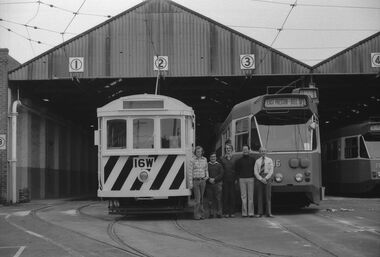 Ballarat Tramway Museum
Photograph - Digital image, 28/11/1976 12:00:00 AM
Digital image of a BTPS training / qualification day held on 28/11/1976, at East Preston depot: From left: Richard Gilbert, Peter Hill, Paul Nicholson, Bruce Davey and Jack Chadwick standing between trams 16W (the only tram at the time on the MMTB network with a manual lap brake) and Z16. Peter Winspur advised 18/5/2020: Paul was an M&MTB driver at the time. Peter Hill would have been doing his first day and Jack Chadwick qualified as driver on that day along with Paul. We managed to train Peter in a few weeks as he was back on 19 December! Just in time for the summer running. Inspector Bruce Davey was the trainer/instruction/examiner driver. Image supplied by Paul Nicholson 17/5/2020. See Reg Item 7775 for a photo of just the two cars.trams, tramways, btps, training, z class trams, east preston, mmtb, tram 16w, tram 16 -
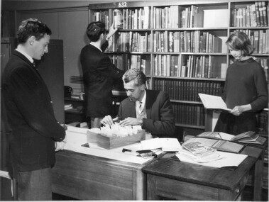 University of Melbourne, Burnley Campus Archives
Photograph, Students and Staff Member in the Library
Students and Staff Member in the Library. Mounted on boardstudents, staff, library -
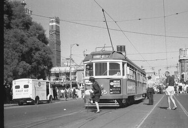 Melbourne Tram Museum
Photograph - Digital Image, changing the points for the cross over in Latrobe St, late 1960's or 1970
Digital image of a photograph from the Ron Scholten Collection of a conductress / conductor changing the points for the cross over in Latrobe St on the east side of Swanston St. The tram has terminated, for a Parade, possibly Moomba during the late 1960's or 1970 as the tram not fitted with side marker lights. In the background is the shot tower with a Penfolds Advert, the Argus building and the ? book Depot. A St Johns ambulance first aid van is parked. The tram has an advert for Queens Bridge Motor Holden and Viva cars (Vauxhall originally) and has a destination of Thornbury - Miller St Tram either SW6 855 or 955.trams, tramways, w6 class, latrobe st, crossover, events, swanston st, thornbury, conductors, conductresses, tram 855, tram 955 -
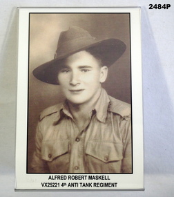 Bendigo Military Museum
Photograph, Est 1940
Alfred Robert Maskell VX25221 4th Anti Tank Regt 2nd AIF, POW. Refer 2485 for medals and service history also 1076, 1100.2. Photo, sepia tone, soldier in uniform. Photo has black edging with details of the soldier underneath."Alfred Robert Maskell VX25221 4th Anti Tank Regt"photography, military, history -
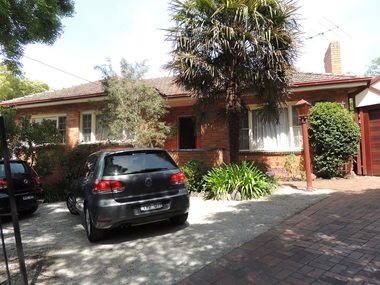 Surrey Hills Historical Society Collection
Photograph - 3 Kenmare Street, Mont Albert, The Street Where You Live Project
Photos documenting this address as part of a photographic series undertaken by volunteer photographers during 2013 and 2014 for The Street Where You Live Project. This was organised through the Surrey Hills Neighbourhood Centre and covered the postcode 3127 in the cities of Boroondara and Whitehorse.These photos provide a snapshot of real estate in the suburbs of Mont Albert and Surrey Hills during a period of rapid change with many properties on large blocks demolished to create higher density residential development or renewal of single dwellings. At particular risk were properties not covered by heritage overlays, especially interwar housing and post 1950's housing. -
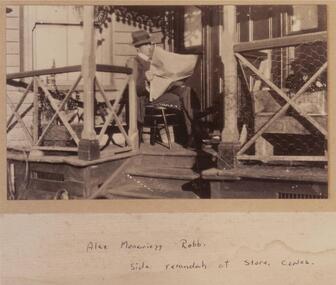 Phillip Island and District Historical Society Inc.
Photograph - Photographs, black + white, Robb Bros. General Store Cowes Phillip Island, c.1920
Mr Robb purchased the General Store in about 1904. Photo in 1905. They owned the store until 1924. Names of people written on back. See photo.Two sepia photographs of Robb Bros Cowes General Store. Photograph 251-01 show Alex Moncrieff Robb sitting reading the newspaper on the side verandah of the General Store, Cowes. Photograph 251-02 shows people outside the front of the General Store., 1905. Horse and cart to the left of the photograph.Alex Moncrieff Robb. Side verandah at Store, Cowes.robb bros general store cowes, alex moncrieff robb, cowes general store phillip island, mary karney, jim pearce, harmon west, phil west, harry walton, david henry robb -
Glenelg Shire Council Cultural Collection
Photograph - Photograph - Portland Library, Victoria, 27/09/1999
Photographs of Portland Library - late 1990s to early 2000s, showing activities at the library and construction of additions to the building.Coloured photo. Portland Library. Same subject as 9537, but with a man and 2 animal puppets in front of the screen.Front: '99 9 27 -
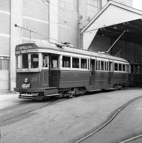 Ballarat Tramway Museum
Photograph - Black & White Photograph/s - set of 2, Geoff Grant, 2/04/1955 12:00:00 AM
Black & White photo of SECV Geelong No. 39 standing outside Geelong depot shed, prior to running in AETA tour on 2/4/1955. Destination showing "SPECIAL" and AETA tour board on front bumper of tram. N261 envelope - "One man operation car No. 39 standing outside depot. AETA Tour, Geelong 2nd April 1955" .1 - Copy large format print from Lloyd Rogers collection via Robert Green 2/2014. Added 4-4-2019 Original negative scanned at hi res 18/5/2020 and image updated.On rear in typed paper "Car no 39 one man operation car standing at Geelong depot for AETA tour. April 2 1955" and "Geoff Grant" stamp on btm rh corner. .1 - In ink in bottom left hand corner - "Geelong Depot - One man car 2-4-1955"trams, tramways, geelong, aeta, tours , tram 39 -
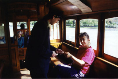 Ballarat Tramway Museum
Photograph - Colour Photograph/s, Warren Doubleday, 1/10/1993 12:00:00 AM
Colour Photograph, postcard size of a BTM Conductor (Darren Hutchesson) selling a ticket to a lady passenger, within tram 26 while travelling on Wendouree Parade (actually at Carlton St. terminus). Photo taken October 1993. 2nd copy added 2/2002 - on Fujichrome paper.2nd copy has "WAD" initials on rear in ink.btm, conductors, tickets, tram 26 -
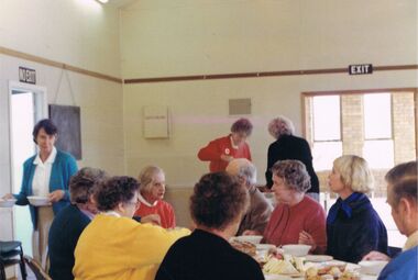 Bendigo Historical Society Inc.
Photograph - COLOUR PHOTO: LUNCHTIME WOODSIDE HISTORICAL SOCIETY, June 1988
colour PHOTO -lunchtime . Woodside historical society june 1988photograph, person, male / female, woodside historical society -
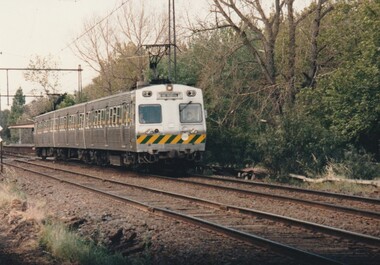 Port Melbourne Historical & Preservation Society
Photograph - Last electric train to Port Melbourne, Glen Stuart, 10 Oct 1987
Photos taken by the donor Glen Stuart on the last day of the train service, which finally cut out about 4.30 on the Saturday afternoonOne from a set of eight colour photographs of the last electric train to Port Melbourne before the closure of the line on 10.10.198710.10.87 typed on rear of each phototransport - railways, north port railway station -
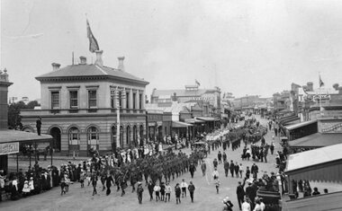 Stawell Historical Society Inc
Photograph, W W 1 Uniformed Soldiers in a procession in Main Street Stawell 1918
Main Street Procession near Post Office 1918. Soldiers in Uniform WW1stawell world war 1 streetscape