-
 Eltham District Historical Society Inc
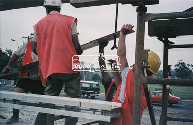
Negative - Photograph, Construction work, Main Street Bridge, Greensborough, c.Dec. 1983
The original bridge over the Plenty River was replaced by a single lane bridge each way fed by two lanes each way on either side. As traffic grew a second bridge was added to complete the divided road across the riverFilm - Kodak CM 400 5079 7 strips, 26 framesinfrastructure, roads, bridge construction, greensborough, main street bridge, road construction -
 University of Melbourne, Burnley Campus Archives
Negative - Colour negatives, Saline Soil Tolerant Plants
2 rolls of negatives labelled, "Week 4 Saline soil tolerant plants rolls 1 & 2." Not digitised.saline soil tolerant plant, plants -
 Kew Historical Society Inc
Map, MMBW, MMBW Plan No.68 Kew, 1900-1910
The Melbourne and Metropolitan Board of Works (MMBW) was established by an act of the Victorian Parliament in 1890 to prepare for and to implement a sewerage and water reticulation system across what was then inner Melbourne, its surrounding and middle distance suburbs, including Kew. The MMBW was disbanded in 1991.The map collection of the Kew Historical Society has at its core the historic maps assembled and originally stored in the City Engineer's Department of the City of Kew. These include maps in a number of scales. The vast majority of maps were produced by the MMBW in the first two decades of the twentieth century, and are solid working maps, backed by linen for durability. These maps are historically significant to Kew, the City of Boroondara and to the history of the development of state utilities in Victoria. A number of the Kew maps have additional details added by former municipal officers, including the levels reached by various floods. As these were working documents, information was added to them long after the period of their initial production and distribution.Early map of part of the Borough of Kew, created in the first decade of the twentieth century, at a scale 160 ft to 1 inch. The map covers what was then the north central part of Kew, bordered in the north by Oak Avenue, in the west by the Yarra River and Connor's Creek, in the south by Beresford and Carnegie Avenues, and in the east by Glass's Creek and Burke Road. The map shows the extent of urban development by that time, prominent institutions and the outlines of built structures in the municipality. Contour lines and the levels of historic floods were added in ink to the map at a later stage.MELBOURNE AND METROPOLITAN BOARD OF WORKS / PLAN NO. 68 / KEW melbourne & metropolitan board of works, mmbw maps, mmbw plans, borough of kew, cartography -
 Eltham District Historical Society Inc
Negative - Photograph, J.A. McDonald, One Tree Hill Road Bridge, Christmas Hills, 2 July 1962
One Tree Hill Road Looking south 2/7/62 The bridge was destroyed by bushfires 15-16 January 1962. A temporary bridge was set up to the east sideRecord of various Shire of Eltham infrastructure works undertaken during the period of 1952-1962 involving bridge and road reconstruction projects, sometimes with Eltham Shire Council Project Reference numbers quoted. It was during this period that a number of significant improvements were made to roads and new bridges constructed within the shire that remain in place as of present day (2022). In many situations, the photos provide a tangible visible record of infrastructure that existed throughout the early days of the Shire. The album was put together by or under the direction of the Shire Engineer, J.A. McDonald.1962-07-02, bridge construction, christmas hills, infrastructure, shire of eltham, victorian bushfires - 1962, bush fires, one tree hill road, property damage -
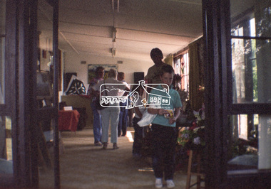
 Eltham District Historical Society Inc
Negative - Photograph, Open Day, Eltham Living and Learning Centre, 7 Nov 1987
Shire President Cr Alan Baker with Gillian Barclay, Coodinator Living and Learning and Rodney Roscholler CEO Eltham Shire Council at the Open Day, Eltham Living and Learning Centre, part of the Eltham Community Festival activites, 7 Nov. 1987eltham, eltham festival, eltham living and learning centre, living and learning centre, open day, cr. alan baker, gillian barclay, rodney roscholler -
Stawell Historical Society Inc
Map, William, County of Borung, Shire of Stawell, 1945
William, County of Borungstawell -
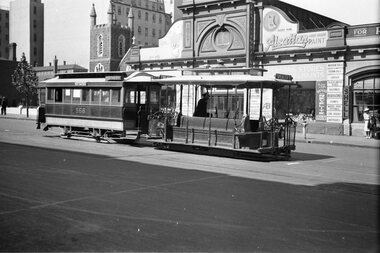
 Melbourne Tram Museum
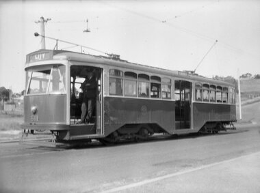
Negative - Copy - Y1 611 Wattle Park, Ray Pearson, early 1930s
Copy negative of a photograph of Y1 611 at the Wattle Park terminus in Riversdale Road, prior to the construction of the shops that were built behind the tram. The driver is standing in the open doorway. The tram line to the Wattle Park terminus opened in 1928. The tram entered service in 1930. Photo early 1930s.Yields information about W5 808 soon after construction.Copy negative of a black and white photographtramcars, tramways, wattle park, y1 class, riversdale road, tram 611 -
 Whitehorse Historical Society Inc.
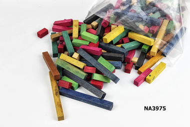
Education kit - Cuisenaine Blocks
Used in schools to teach maths during 1960-70s. Used by Julie Jones at 10 Francis Street, Blackburn.Set of Cuisenaine Rods, multicoloured. Used as an educational tool to teach children maths. Wood was stained in different colours to donate a numeric value.school, equipment -
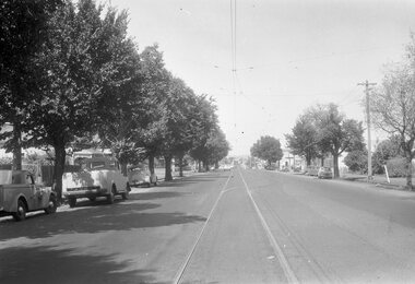
Whitehorse Historical Society Inc.
Map, Whitehorse Road, Blackburn, 1970
Enlarged aerial photograph of area around intersection of Whitehorse and Middleborough Roads, BlackburnEnlarged aerial photograph of area around intersection of Whitehorse and Middleborough Roads, BlackburnEnlarged aerial photograph of area around intersection of Whitehorse and Middleborough Roads, Blackburnwhitehorse road, blackburn, middleborough road, blackburn, maroondah highway, box hill, aerial photographs -
 Melbourne Tram Museum
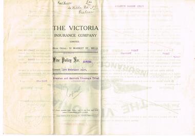
Legal record - Insurance Policy, The Victoria Insurance Company Limited, "Rest House L50 St Kilda Rd No. 5 Prahran", 3/02/1913 12:00:00 AM
Insurance Policy - eight fold - titled "Fire Policy No. 569750 for PMTT Rest House L50 St Kilda Rd No. 5 Prahran" from The Victoria Insurance Company Limited, expiring 3/2/1914, issued to the Prahran and Malvern Tramways Trust, Details location, sum insured, 50 pounds, premium, dates. Has the seal of the insurer in the bottom right hand corner."Rest House L50 St Kilda Rd No. 5 Prahran" along top folded edge.trams, tramways, pmtt, insurance, shelters, st kilda rd, high st, prahran -
Stawell Historical Society Inc
Map, Gampola, County of Borung, 1957
Gampola, County of Borungstawell -
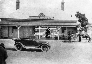 Eltham District Historical Society Inc
Negative - Photograph, Thornton's Kangaroo Ground Hotel
Reproduced on p21 of 'Pioneers & Painters' Mrs. R. Thornton notifies that she has taken over the Kangaroo Ground Hotel from Mr. Walker, and the house will be made attractive for weekenders, the table, wines, and spirits being A1 quality" - Advertiser 7 July, 1922" Mrs Ruby C. Thornton sold her interest in the Kangaroo Ground Hotel in September 1928 and moved away after seven years in the district. This photo is therefore dated between July 1922 and 1928. Other newspaper articles identify Mrs Thornton's first name. The lady to the left of frame appears to be taking a photograph of the car in front of the hotel. This may be Mrs Ruby Thornton taking a picture of her car in front of her hotel. A young boy with others standing near their horse and buggy look on. The property was destroyed by fire at 1.45 am on Friday 8 August 1930. The licensee was Mr Hugh Crichton who had taken over from Ruby Thornton. He and his wife just managed to escape the fire with nothing but their night attire. The property was owned by Mr Bruce Donaldson of Ivanhoe and had been erected over 60 years earlier (according to the Advertiser). In older times it was a famous hostelry at which Cobb & Co.’s coaches had a changing station on the journey from Alexandria to Melbourne.This photo forms part of a collection of photographs gathered by the Shire of Eltham for their centenary project book,"Pioneers and Painters: 100 years of the Shire of Eltham" by Alan Marshall (1971). The collection of over 500 images is held in partnership between Eltham District Historical Society and Yarra Plenty Regional Library (Eltham Library) and is now formally known as the 'The Shire of Eltham Pioneers Photograph Collection.' It is significant in being the first community sourced collection representing the places and people of the Shire's first one hundred years.Digital image 120 format B&W negative Print 20 x 25 cm Print 9 x 12.5 cmshire of eltham pioneers photograph collection, kangaroo ground, kangaroo ground hotel, thornton, automobile, pioneers and painters, mrs ruby thornton, cobb and co, ford model t, horse drawn carriage, hotel -
 Melbourne Tram Museum
Negative, Wal Jack, 19/01/1941 12:00:00 AM
Black and white negative by Wal Jack of U206 and five maximum traction cars - N 125, C 28, P 138, E 143 and another ex HTT car stored at Preston Workshops. The car numbers were detailed in the album held by the Ballarat Tramway Museum. Photo dated 19-1-41trams, tramways, preston workshops, u class, c class, n class, e class, p class, stored trams, tram 206, tram 125, tram 28, tram 38, tram 143 -
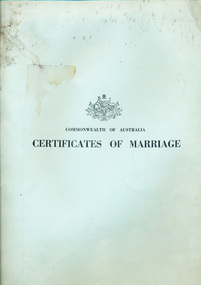 Mission to Seafarers Victoria
legal record (item) - Register Receipts, Circa 1972
The receipts are dated from the 26th of August 1972 to the 1st of February 1975. They document some of the information needed on the actual marriage certificate, such as the date and location, bride, bridegroom and celebrant's names, as well as the date the each certificate was sent to registering authority.Part of the record of weddings performed at the Mission to Seafarers between 1972 to 1975.Printed on front cover: COMMONWEALTH OF AUSTRALIA / CERTIFICATE OF MARRIAGE. The Australian crest is printed above this.marriage, wedding, register, receipt, 1972-1975, mission-to-seafarers, port-melbourne, marriages, dio-marriages, st peter chapel, st andrew chapel -
 Marysville & District Historical Society
Map (Item) - Tourist Map, Tourists Resorts' Committee, Tourist's Map of Healesville Marysville and Warburton Districts, 13.10.1925
A tourist map for Healesville, Marysville and Warburton that was produced by the Tourists Resorts' Committee. This map was produced in 1925.A tourist map for Healesville, Marysville and Warburton that was produced by the Tourists Resorts' Committee.Photo Lithographed at the Department of Lands and Survey, Melbourne by W.J. Butson./ 13.10.25healesville, marysville, warburton, victoria, tourists resorts' committee, ben cairn, mount donna buang, the black's spur, the acheron valley, narbethong, launching place, tourist information, tourism, map, tourist map -
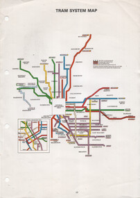 Melbourne Tram Museum
Map, The Met, "Tram System Map", c1990
Tram system map published by The Met to show the various Melbourne tram routes, route numbers, principal road names, suburbs and tram routes within the Central Business District.Provides information about Melbourne tram routes c1990Printed A4 full colour sheet with four punch holes on left hand side.tramways, melbourne, the met, map, tram routes, routes -
 Eltham District Historical Society Inc
Negative - Photograph, Open Day, Eltham Living and Learning Centre, 7 Nov 1987
Open Day, Eltham Living and Learning Centre, part of the Eltham Community Festival activites, 7 Nov. 1987eltham, eltham festival, eltham living and learning centre, living and learning centre, open day -
 Bendigo Historical Society Inc.
Legal record - Register of Special Land Sales Castlemaine, 28/06/2007
Light brown suede leather cover with ornate embossed edging; and label on spines stating "3 and Register of Special Land Sales". Land sales between 7/03/1862 to 20/04/1869, Castlemaine District on spine. Fine black handwritten entries. First page notes Report of a Sale on the 7th March 1862, in terms of Gazette notice of 7th July 1862. Sale conducted by Public Auction by Thomas Couchman Esq. Acting D.S.land sales, castlemaine, 1860s -
Stawell Historical Society Inc
Map - Electoral Map, Local Government, Local Government Boundry Status as at 31st January 1995, 1995
Electoral mapTwo (2) Maps Overprinted in Red Showing Local Government Boundries for State and port Phillip AreaSheet 1 of 2 Sheet 2 of 2government -
Whitehorse Historical Society Inc.
Legal record - Land Title, Moffatt land, 1925
Certificate of Title Vol.5039 Fol. 703 29 September 1925.Certificate of Title Vol.5039 Fol. 703 29 September 1925, 2 acres 2 roods and 13 perches, bakers Road Blackburn, from William James Moffatt to Edith Sarah Moffatt, 6 September 1946 and Arthur Vernon Moffatt 6 September 1946Certificate of Title Vol.5039 Fol. 703 29 September 1925.moffatt, william james, moffatt, edith sarah, moffatt, arthur vernon, bakers road blackburn -
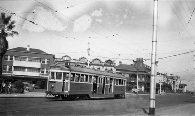
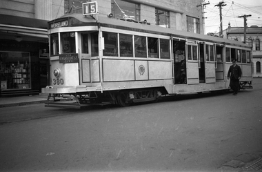 Melbourne Tram Museum
Negative, Wal Jack, c1938
Black and white negative, by Wal Jack, of W2 380 (Moreland Route 15), at the Acland St, St Kilda terminus 1938. Note the Coburg Depot Run Number. Mal Rowe advised by e-mail 21/9/20 (from the Norm Cross notes) that To commemorate 25 years of the opening of Luna Park in St. Kilda, No’s 235, 249, 303, 380, 422, 454 and 568 were painted silver with dark blue trim and suitable sign writing. Mal noted that W2 568 was given the years 1913-1938 and lights around the roof.trams, tramways, w2 class, acland st, st kilda, route 15, luna park, tram 380 -
 Eltham District Historical Society Inc
Negative - Photograph, Eltham - Wingrove Park, early 1950s
Scar tree in foreground of Wingrove Park, named for Charles Symons Wingrove who was Secretary and Engineer for the Shire of Eltham for almost 50 years This photo forms part of a collection of photographs gathered by the Shire of Eltham for their centenary project book,"Pioneers and Painters: 100 years of the Shire of Eltham" by Alan Marshall (1971). The collection of over 500 images is held in partnership between Eltham District Historical Society and Yarra Plenty Regional Library (Eltham Library) and is now formally known as the 'The Shire of Eltham Pioneers Photograph Collection.' It is significant in being the first community sourced collection representing the places and people of the Shire's first one hundred years.Digital image 4 x 5 inch B&W Negsepp, shire of eltham pioneers photograph collection, eltham, george w bell, main road, wingrove park, tree, scar tree -
Glenelg Shire Council Cultural Collection
Legal record - Identity Card - Robin Kiel, Aug-44
Form C.R.3 Civilian Registration (British Subjects). Identity card issued to Robin Kiel Buln Buln East, via Waragul, 16 AUG. 1944. Cardboard, two red vertical lines, front and back of card, black print, holder's details and witness signature handwritten -
Stawell Historical Society Inc
Map, Geological Survey of Victoria
Geological Survey of Victoriastawell -
 Melbourne Tram Museum
Negative, Wal Jack, 1940
Black and white negative, by Wal Jack, of a cable tram set, trailer 568 waiting to enter the terminus at Bourke St, c1940. Tram has the destination of Spencer with the trailer having the side destinations of Northcote and Smith St. Note the lady with an overcoat and suitcase on the right side of the photo. In the background is the Peoples Palace, Hudson's Stores, advertising Alsatian paints, Dockers Revelite paints, tools, Shell products. Also St. Augustine's Parish church and the West Melbourne police station watch house.trams, tramways, cable trams, bourke st, tram 568 -
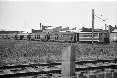
 Ballarat Tramway Museum
Negative - Moorabool St, looking south at the Kardinia Park loop, early 1956
Photo shows Moorabool St, looking south at the Kardinia Park loop. One of a set of photos was taken between 15/2/1956 and 3/3/1956 when services operated only between Belmont and North before the final closure of the Belmont route on 25/31956 and that bogie tram 31 is not shown on the board, having gone to Ballarat on 15/2/1956 - see item 5554. See item 8213 for an article on the Geelong system by Keith Kings. Yields information about the Geelong tram system.Black and white Negative - 120 sizetramways, geelong, moorabool st, kardinia park loop -
Stawell Historical Society Inc
Map, Township of Stawell
B/W map of Stawell Surveyed by Easton Johnston Contract surveyor Scale in Chains. Showing Special Allotments Reefs, Pleasant Creek Parish of Stawell. Map No L4000 -
Whitehorse Historical Society Inc.
Education kit - Article, It's time to share our stories, 2004
Article about the 'Sharing Australia's Stories' project and states that Whitehorse Historical Society and Valda Arrowsmith will be involved.Article about the 'Sharing Australia's Stories' project and states that Whitehorse Historical Society and Valda Arrowsmith will be involved.Article about the 'Sharing Australia's Stories' project and states that Whitehorse Historical Society and Valda Arrowsmith will be involved.sharing australia's stories project, whitehorse historical society, arrowsmith, valda -
 Melbourne Tram Museum
Negative, Wal Jack, c1954
Black and white negative, by Wal Jack, of W2 529 in Beaconsfield Parade, St Kilda at the tram terminus for route 1 tram. Has the buildings in Fitzroy St in the background. The tram has the destination of route 1, East Coburg. c1954? On the buildings are "RGK", a Coffee Lounge, D F Reszke Cigarettes, Penfolds Winestrams, tramways, w2 class, beaconsfield parade, fitzroy st, route 1, tram 529 -
 Warrnambool and District Historical Society Inc.
Map, Colour Photograph