-
 Melbourne Tram Museum
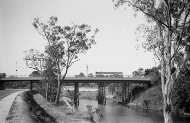
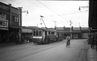
Negative - Set of 2, Ellis Collection, c1940?
Set of two Negatives (120) of a wide body car crossing the Wallen St Road Bridge Hawthorn possibly after the construction of The Boulevard. Taken from either side of the river. Hi Res image filed in the dbtext/hawthtramcoll/Large Images/htd3595aLarge.jpg and htd3595bLarge A low resolution A4 laminated was received with the negatives. Image i2 - taken from Glan Avon Rd in Hawthorn of Wallen Rd bridge – the tram is one of three SW2 class trams (not the first one due to the door sizes, but one of 426, 432 or 478, most probably 478 as that was a Camberwell car)trams, tramways, wallen rd, bridges, sw2 class -
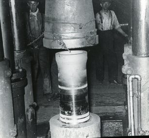
 Ballarat Tramway Museum
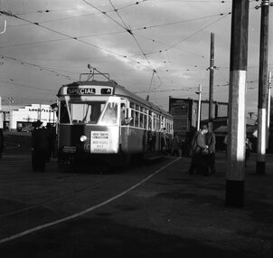
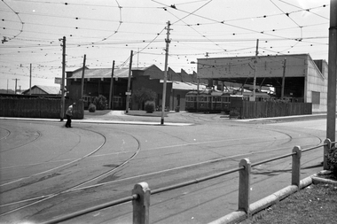
Negative, Geoff Grant, 25/06/1955 12:00:00 AM
Negative No. N350 and black and white print made by a laser printer (stored in folder ) of tram 980 on AETA tour (Australian Electric Traction Association) on 25/6/1955 entering shed roads at the then new East Preston depot. Tram has AETA tour signs and the slogan "Save traffic congestion, Move People not vehicles". In route number box is letter "A". Negative scanned hi res and imaged updated 22/5/2020.trams, tramways, melbourne, preston depot, aeta tour, tram 980 -
 University of Melbourne, Burnley Campus Archives
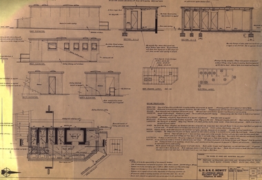
Plan, Detail of Sterilizing Trolley for New Plant Science Laboratory at Burnley Horticulture College, c. 1960
Plan by State of Victoria, Dept of Public Works. Drawn by R.M.department of public works -
 Ballarat Tramway Museum
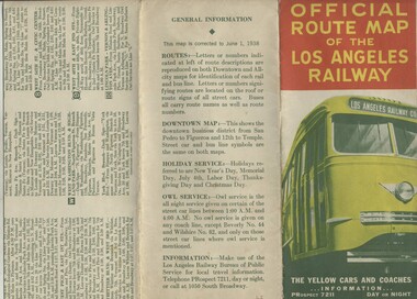
Map, H.P. Noordwal, "Official Route Map of the Los Angeles Railway", Jun. 1938
A (12 section) fold out map of street car (tram) and bus services for Los Angeles, dated June 1, 1938, showing all LAR (Los Angeles Railway) streetcar and coach (tram and bus) services, Pacific Electric lines within area, detailed "downtown" map, route descriptions and points of interest. Record images added 20/8/2013.Three terminus have been marked with pencil "X". On rear car, next to object number is a symbol looking like a "H & S" merged together.trams, tramways, los angeles, street cars, map -
 Federation University Historical Collection
Plan, Ballarat School of Mines Trade Toilet Block Alterations and Renovations, 1976, 04/08/1976
Computer generated planballarat school of mines, toilet block -
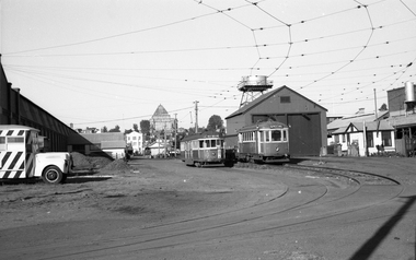 Melbourne Tram Museum
Negative, Wal Jack, 11/03/1962 12:00:00 AM
Black and white negative, by Wal Jack, of W2 572 (West Preston, route 11) and Scrubber Tram No. 10 and a ballast trailer in the yard at South Melbourne depot - c1960, though the yellow flashing lights on the roof line may indicate a later photo. In the background is a MMTB works vehicle, the Shrine of Remembrancetrams, tramways, south melbourne depot, w2 class, scrubber tram, work trams, west preston, route 11, tram 572, tram 10 -
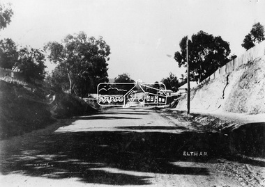 Eltham District Historical Society Inc
Negative - Photograph, J.H. Clark, Main Road, Eltham, c.1908
Gahan house on left, bakery on right at corner of York Street, Shillinglaw Cottage in distance. Newly constructed footpath (refer SEPP_0616) on eastern side between York Street and Bridge Street. Photo by J.H. Clark - John Henry Clark was one of four brothers that ran a photography business, Clark Bros. from 25 Thomas Street, Windsor between c.1894 and 1914. Source: Mr. L. Jarrold, Dromana, (formerly Eltham) Photographer: J.H. Clark John Henry Clark was the youngest of three boys born to William Henry Clark (1823-1877) and Maria White (1843-1914). He and his brothers, William Charles Clark (1872-1945), Clement Kent Clark (1874-1912) operated a photography business (Clark Bros.) from 25 Thomas Street, Windsor near Prahran during the period c.1894 to 1914. Following death of Clement in September 1912 and their mother in 1914, the Clark Bros business appears to have dissolved, the premises demolished, and a new house was under construction in 1915. John set up business independently in 1914 operating out of 29 Moor Street, Fitzroy where he is registered in the 1914 and 1915 Electoral Rolls. By 1916 John had relocated to Eltham where he continued his practice as a photographer and took many of the early images around the district of Little Eltham. Around 1930 John changed professions and opened a small cobbler's shop in 1931 near the pond opposite Dalton Street adjacent to the Jarrold family cottage. He never married and continued his profession as a bootmaker from this little shop, maintaining a close relationship with Mrs Jarrold for the rest of their lives. His bootmaker shop remains today beside the Whitecloud cottage and is one of only three remaining shops in the area from the early 20th century. There are a couple of images of Eltham taken by Clark Bros. in the Eltham District Historical Society collection, one such example being Hunniford’s Post Office with Miss Anne Hunniford out front (EDHS_00140 - marked on the back of the print, Clark Bros., 25 Thomas St. Windsor), which would date this image between c.1894 and 1914. Other early images of Eltham taken by John Henry Clark are marked on the face “J. H. Clark Photo” and it is assumed these are dated between 1914 and 1930. It is noted that the Grant of Probate for John H Clark of Eltham South dated 5 April !957 (513/387) records his occupation as "X Photographer".This photo forms part of a collection of photographs gathered by the Shire of Eltham for their centenary project book,"Pioneers and Painters: 100 years of the Shire of Eltham" by Alan Marshall (1971). The collection of over 500 images is held in partnership between Eltham District Historical Society and Yarra Plenty Regional Library (Eltham Library) and is now formally known as the 'The Shire of Eltham Pioneers Photograph Collection.' It is significant in being the first community sourced collection representing the places and people of the Shire's first one hundred years.Digital image 4 x 5 inch B&W NegJ.H. Clark Photoshire of eltham pioneers photograph collection, eltham, main road, gahan house, bakery, bridge street, footpath, j.h. clark photo, shillinglaw cottage, shillinglaw trees, york street -
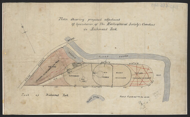 University of Melbourne, Burnley Campus Archives
Plan, John S. Jenkins, Plan showing proposed adjustment of boundaries of the Horticultural Society's Gardens in Richmond Park, c.1880-1884
Plan on linen fibre cloth. Shows layout of Burnley bound by Swan St., Yarra River and part of Richmond Park, coloured areas showing proposed area to be added to Park, the old road, shrubbery, new hall, old garden, recent extension and proposed further extension (crossed out in red ink). Scale 4 chains:1 inch. Probably drawn by John S. Jenkins, Town Surveyor, Richmond. Has been photographed so that additional copies can be made. On a CD plus 3 negatives. (Also copy glazed and framed for Centenary Exhibition.)john s. jenkins, gardens, richmond, hoticultural society of victoria -
Glenelg Shire Council Cultural Collection
Negative - Glass Plate Negative - Bentinck Street Portland, c. 1890
Stereoscopic glass plate negative. Image shows a man holding 2 bicycles, Bentinck Street south (Cape Nelson Road) looking north from near Must Street. -
Bendigo Historical Society Inc.
Plan - SANDHURST BOYS CENTRE COLLECTION: PART DETAIL SURVEY
Prepared by the Public Works Department for the Government of Victoria. Client is the Mental Health Department, Municipality is City of Bendigo. Site plan of area bounded by O'Dwyer St and Finn St, North Bendigo. Handwritten note on back - Update of whole centre 10/4/91. Details include: oval, tennis court, grandstand, area is bounded by an un-named watercourse. Also indicated are 14 nissen huts, 2 toilet blocks, 3 weatherboard buildings, 1 galvanised iron building,2 galvanised iron sheds (one new), residence, garage, fowl shed, and a carpark. Location unknown 16.02.2023.bendigo, institutions, sandhurst boys centre, sandhurst boys centre site plan; -
 Mission to Seafarers Victoria
legal record (item) - Register, marriages, Register no 3, Nos 22 to 40 (Sept 15th 1923 to May 1st 1935, 1923
All the weddings performed in the St Peter Chapel from September 1923 to May 1935 are documented in the register. Each page records the necessary information for the marriage to be registered legally in the Commonwealth of Australian.The register is a record of the weddings conducted at the St Peter Chapel between the 15th of September, 1923 to the 1st of March, 1935.Handwritten in black ink on front cover: REGISTRATION NO 3. / NOS 22- 40 (SEPT 15TH 1923 TO MAY 1ST 1935. Stamped in purple ink in top left corner: FROM / THE MISSION / TO SEAMEN / MELBOURNE.wedding, mission to seafarers, seamen's mission, mission to seamen, st peter chapel, marriage, register, record, flinders street, dio-marriages, dio-archives -
University of Melbourne, Burnley Campus Archives
Plan, Department of Agriculture - Victoria Burnley Gardens Hort. College Facilities, 1973-1983
Partly handdrawn plan of the horticultural facilities at Burnley Gardens.facilities, burnley gardens -
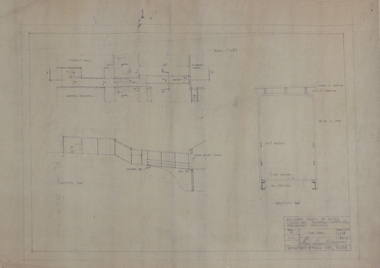 Federation University Historical Collection
Plan, Ballarat School of Mines Preliminary Drawings for a Covered Way between Plumbing and Tippett Hall, 1962, 09/01/1962
Plan includes Ballarat School of Mines Administration Building and Tippett Hall (former Wesley Church)ballarat school of mines, architectural plan, plumbing, tippett hall, former wesley church, former ballarat school of mines museum -
 Kew Historical Society Inc
Plan, Melbourne & Metropolitan Board of Works : Borough of Kew : Detail Plan No.1582, 1904
The Melbourne and Metropolitan Board of Works (MMBW) plans were produced from the 1890s to the 1950s. They were crucial to the design and development of Melbourne's sewerage and drainage system. The plans, at a scale of 40 feet to 1 inch (1:480), provide a detailed historical record of Melbourne streetscapes and environmental features. Each plan covers one or two street blocks (roughly six streets), showing details of buildings, including garden layouts and ownership boundaries, and features such as laneways, drains, bridges, parks, municipal boundaries and other prominent landmarks as they existed at the time each plan was produced. (Source: State Library of Victoria)This plan forms part of a large group of MMBW plans and maps that was donated to the Society by the Mr Poulter, City Engineer of the City of Kew in 1989. Within this collection, thirty-five hand-coloured plans, backed with linen, are of statewide significance as they include annotations that provide details of construction materials used in buildings in the first decade of the 20th century as well as additional information about land ownership and usage. The copies in the Public Record Office Victoria and the State Library of Victoria are monochrome versions which do not denote building materials so that the maps in this collection are invaluable and unique tools for researchers and heritage consultants. A number of the plans are not held in the collection of the State Library of Victoria so they have the additional attribute of rarity.Original survey plan, issued by the MMBW to a contractor with responsibility for constructing sewers in the area identified on the plan within the Borough of Kew. The plan was at some stage hand-coloured, possibly by the contractor, but more likely by officers working in the Engineering Department of the Borough and later Town, then City of Kew. The hand-coloured sections of buildings on the plan were used to denote masonry or brick constructions (pink), weatherboard constructions (yellow), and public buildings (grey). Public buildings, coloured grey on the Plan 1582 include the police station and post office, churches and schools. The earliest church school, Common School No.356 was located at the rear of the Congregational Church in Peel Street. It was constructed in 1859. The first buildings of Kew Primary School No.1075 on the other side of Peel Street were constructed in 1871. The school in 1903 only occupied a small fraction of its current site. In 1903, where the rear playground is now located, were two weatherboard and one brick villa. Trinity Grammar School was founded in 1902 and opened in the Parish Hall at the rear of Holy Trinity Anglican Church. It was not to move to its current site until 1906. The outline of the building housing the Kew Fire Brigade in the centre of the north side of Walton Street is shown but not named on the plan. Further down Pakington Street stood the two-storey Italianate mansion ‘Overton’. The home of Stanford Chapman, it was to be featured in the Imperial Institute series of bromide photographs of Victoria, Vol. 1: Homes and scenery. It was later to become a boarding house before it was later demolished.melbourne and metropolitan board of works, detail plans, maps - borough of kew, mmbw 1582, cartography -
University of Melbourne, Burnley Campus Archives
Plan, David Reid, Dandenong College of T.A.F.E. Landscape Design, 1988
Student plans. (1) Master Plan by David Reid for Landscape Graphics 4, dated 17.10.1988. Scale 1:250. (2) Master Plan No 2 by L. Garnett October 1988. Scale 1:250. (3) Master Plan by Steve Soso for Landscape Graphics 4 dated 18.9.88. Scale 1:250.david reid, steve soso, landscape design -
Whitehorse Historical Society Inc.
Map, Deakin, 1977
Map of the Commonwealth Electoral Division of Deakin. Scale 1: 25,000.Map of the Commonwealth Electoral Division of Deakin. Scale 1: 25,000.Map of the Commonwealth Electoral Division of Deakin. Scale 1: 25,000.electoral boundaries, deakin (commonwealth electoral division), australia. parliament -
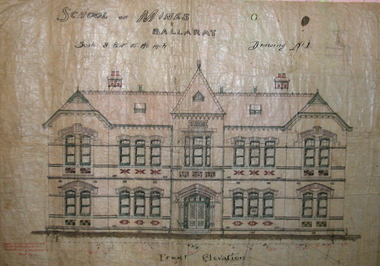 Federation University Historical Collection
Plan, Ballarat School of Mines New Classrooms (now Administration Building), 1899, 16/02/1899
In 1900 this building was described as 'handsome in design, well lit, well ventilated, commodious - containing Council room, office, chemical laboratory, mineralogical laboratory, students room and six lecture rooms. Original hand coloured plan on linen of the Ballarat School of Mines New Classrooms (in 2014 known as the Federation University Australia SMB campus Administration Building). The plan shows the front elevation, section on line, ground and 1st floor plan. Copy in black frame with cream mount.ballarat school of mines, new classrooms, administration building, architectural plans, a building -
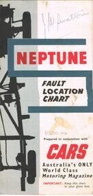 Bendigo Historical Society Inc.
Map - J W SWATTON COLLECTION: MAPS
Seven maps of various sizes. Map of the City of Ballarat, Victoria, Road Condition Map of Victoria including Melbourne-Cairns & Melbourne-Adelaide, Neptune Fault Location Chart, Grampians District Map, Racv Tour Planning Map Showing Road Conditions for Victoria, NSW and Queensland and Mt Macedon & District. Two of the maps have J W swatton & J Swatton written on them.j w swatton collection, racv, mobil, neptune, a r blair, j ewins & sons pty ltd, berry anderson & co -
Glenelg Shire Council Cultural Collection
Plan - Ship Plan / Mould, n.d
Wooden pattern for mould for boat fittings. Two pieces 'butterfly' shaped, turned up ends, hump in centre, small half cylinder attached eitehr side of hump. Flat underside, holes for attaching to other half of pattern. Painted brown, underside unpainted. -
Federation University Historical Collection
Map, Topographical Map Creswick A & B
Printed map on papercreswick, clunes, lexton, waubra, smeaton -
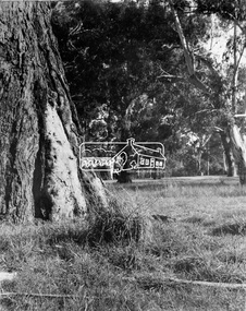 Eltham District Historical Society Inc
Negative - Photograph, Eltham - Wingrove Park, early 1950s
Scar tree in foreground of Wingrove Park, named for Charles Symons Wingrove who was Secretary and Engineer for the Shire of Eltham for almost 50 years This photo forms part of a collection of photographs gathered by the Shire of Eltham for their centenary project book,"Pioneers and Painters: 100 years of the Shire of Eltham" by Alan Marshall (1971). The collection of over 500 images is held in partnership between Eltham District Historical Society and Yarra Plenty Regional Library (Eltham Library) and is now formally known as the 'The Shire of Eltham Pioneers Photograph Collection.' It is significant in being the first community sourced collection representing the places and people of the Shire's first one hundred years.Digital image 4 x 5 inch B&W Negsepp, shire of eltham pioneers photograph collection, eltham, george w bell, main road, wingrove park, tree, scar tree -
 Melbourne Tram Museum
Negative, Wal Jack, c1946
Black and white negative, by Wal Jack, of S class 166 (Depot) and an X class in Leeds St before Irving St at Footscray railway station. Photo may be taken on the same day as the other photos of S 166 - 21-4-1945 In the background are View Bakery, Appleton and Wright - Men's Wear, Rainbow Knit Wear, Marx's Laundry and at least one solider.trams, tramways, footscray, s class, x1 class, leeds st, tram 166 -
 Melbourne Tram Museum
Negative, Wal Jack, 19/01/1941 12:00:00 AM
Black and white negative by Wal Jack of the then Preston Depot, Thornbury Depot from St Georges Road, 19-1-1941. A man in a white jacket is sweeping the curve track. Inside the new shed, trams W2 477? (showing City Route 9D), 644 (Thornbury Route 9) and 444 (Thornbury Route 9D)trams, tramways, preston depot, thornbury depot, st georges road, w2 class, route 9, route 9d, tram 477?, tram 644, 444 -
 Bendigo Historical Society Inc.
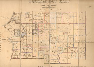
Map - JACK FLYNN COLLECTION: BURRUMBOOT EAST, 21/12/1027
Map: Burrumboot East, County of Rodney. Parish plan.Photo Lithographed at the Department of Lands and Survey, Melbourne by W.J.Butson. 21.12.27map, rodney, parish plan, burrumboot east -
 Ballarat Tramway Museum
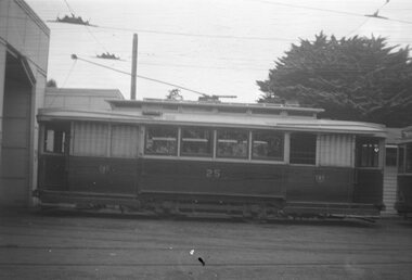
Negative - Black and white print from negative, Travis Jeffrey, 29/11/1959 12:00:00 AM
Negative No. N381 and black and white print made by a laser printer (stored in folder) of Ballarat No. 25 - side on view - on No. 4 road at the SEC depot Wendouree Parade. Has parts of the depot building in the background. Date of photo on folder - 29/11/1959. Original negative rescanned 24/5/2020 and image file updated.Paper folder that contained the negative had "NR9A" in red ink, "BA8" in pencil, date stamp of "29 Nov 1959" on front, and on rear date stamps "26 Sep 1962" and "26 Sep 1962".trams, tramways, sec depot, depot, tram 25 -
University of Melbourne, Burnley Campus Archives
Plan, Alton-Hascombe Feature Survey, c. 1990
1 tracing paper and 2 paper copies, plan by Department of Conservation, Forests and Lands. Division of Survey and Mapping. Scale 1:1000. Plan of property includes buildings, gardens and paddocks. 1 copy has significant buildings coloured.alton-hascombe, survey -
 Bendigo Historical Society Inc.
Negative - Bendigo Munitions Factory (ADI) Glass Slides, Australian Defence Industries (Now THALES AUSTRALIA), c1944
The Bendigo Ordnance Factory began operating in 1942, producing heavy artillery and naval guns. In the late 1990s the then Federal Government-owned facility was sold to the multinational Thales, which continues to operate the factory today. This Bendigo Historical Society collection of glass negatives includes some slides of women working in the munitions factory. Seven slides were included in an album that was prepared for Dr Edith Summerskill who visited Australia in 1944 as part of an Empire Parliamentary Delegation. The album included photographs of Australian women working at the factory during WW2. A copy of the album is in the Collection of the Australian War Memorial.Box 3 of 3, Glass Slide Negatives of the Bendigo Munitions Factory, later known as the Ordnance Factory and then the Australian Defence Industries. Each negative is sealed between two pieces of glass. The edges are sealed with thin pieces of tape. The slides are contained in three wooden boxes with hinged lids and grooves (slots) to house them.history, bendigo, bendigo munitions factory, bendigo ordnance, bendigo adi, doctor edith summerskill, ww2, slide box 1 10165, slide box 2 10166, slide box 3 10167 -
University of Melbourne, Burnley Campus Archives
Plan - Sketch, Widening road for parking. Buildings in College area occupied by other branches, c. 1950
Sketch plan.burnley school of horticulture, roads -
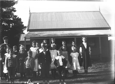 Wodonga & District Historical Society Inc
Negative - Haeusler Glass Negatives Collection - Wodonga West School and pupils, c1910
The Wodonga Historical Society Haeusler Collection provides invaluable insight into life in late nineteenth and early twentieth century north east Victoria. The collection comprises manuscripts, personal artefacts used by the Haeusler family on their farm in Wodonga, and a set of glass negatives which offer a unique visual snapshot of the domestic and social lives of the Haeusler family and local Wodonga community. The Haeusler family migrated from Prussia (Germany) to South Australia in the 1840s and 1850s, before purchasing 100 acres of Crown Land made available under the Victorian Lands Act 1862 (also known as ‘Duffy’s Land Act’) in 1866 in what is now Wodonga West. The Haeusler family were one of several German families to migrate from South Australia to Wodonga in the 1860s. This digital image was produced from one of the glass negatives that form part of the collection, probably taken by Louis Haeusler (b.1887) with the photographic equipment in the Wodonga Historical Society Haeusler Collection. This item is unique and has well documented provenance and a known owner. It forms part of a significant and representative historical collection which reflects the local history of Wodonga. It contributes to our understanding of domestic and family life in early twentieth century Wodonga, as well as providing interpretative capacity for themes including local history and social history.Digital image created from the Haeusler Glass negative collection. A group of students and their teacher standing outside Wodonga West Primary School No. 1058. C.1910. The school was located near the current intersection of McKoy Street and the Hume Freeway in West Wodonga on land donated by J.W. Klinge, replacing an older school north of the railway line. It operated from January 1870 to May 1950 when the nine remaining students transferred to Wodonga Primary School.wodonga pioneers, haeusler family, glass negatives, dry plate photography, wodonga west school -
Bendigo Historical Society Inc.
Map - BENDIGO IRRIGATION SETTLEMENT, 12/02/1908
Map: Plan of Bendigo Irrigation Settlement, Parishes of Sandhurst and Wellsford, County of Bendigo ( number 160 in Map Cupboard 1)map, bendigo, irrigation settlement, bendigo irrigation settlement, parishes of sandhurst and wellsford, county of bendigo