-
 Ballarat Tramway Museum
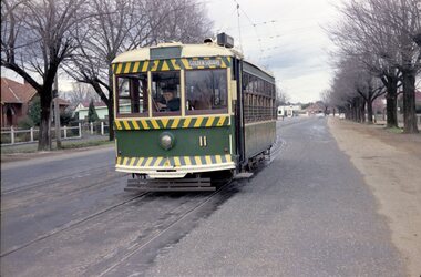
Negative, Travis Jeffrey, 5/08/1962 12:00:00 AM
Colour Negative No. N407, of the Bendigo No 11 on the North Bendigo line at the Bridge St. loop. Tram has the destination of Golden Square. Photo taken possibly on 5/8/1962. Colour laser printed copy of image stored in box 73. Original negative hires scan and image updated 28/5/2020.In red pen on folder that contained negative, "NR95B" and "5 Aug 62". trams, tramways, bendigo, north bendigo, bridge st, tram 11 -
 Bendigo Historical Society Inc.
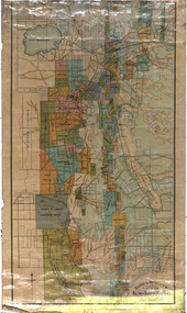
Map - EGERTON : COUNTY OF BENDIGO, 1-3-30
Map. Egerton, County of Bendigo, Minto, Diggorra, Elmore, Nolan, Goornong, Bagshot, Whirrakee. Bendigo Creek. By authority J.J. Green, Govt. Printer. Photo-Lithographed at the Department of Lands and Survey, Melbourne. Price 2/-. 1-3-30. (number 47 in map cupboard 1)J.J. Green, Govt. Printer.map, bendigo, egerton -
 Melbourne Tram Museum
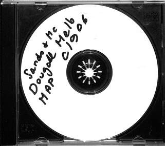
Map - CD - Sands McDougal Map Melbourne c1906, Sands McDougall
Detailed scan of the Sands McDougal Map in colour showing Melbourne's cable trams, railways, Essendon Tramways, NMETL and the Victorian Railways line to Brighton from St Kilda. Includes the MTOCo horse tram lines and the Caulfield horse tram lines. See Reg item 6572 for the actual map. Yields information about Melbourne and its tramways in 1906CD in a plastic case - black with clear cover.CD marked "Sands & McDougal Map c1906"cable trams, tramways, map, sands mcdougal, nmetl, vr trams, horse trams -
Bendigo Historical Society Inc.
Map - TARNAGULLA SHEET 1, Examined 25/08/1926
Map: Tarnagulla Sheet 1, Counties of Gladstone and Bendigo. Parish plan (number 304 in map cupboard 1)map, gladstone, parish plan, tarnagulla -
Whitehorse Historical Society Inc.
Map, Aerial photograph, c1950
Arial photo of Vermont South and Burwood East, Middleborough Road, Burwood Highway, Springvale Road, Highbury Road and environs.Aerial photo of Vermont South and Burwood East, Middleborough Road, Burwood Highway, Springvale Road, Highbury Road and environs.Arial photo of Vermont South and Burwood East, Middleborough Road, Burwood Highway, Springvale Road, Highbury Road and environs.vermont south, burwood east, aerial photographs -
 Melbourne Tram Museum
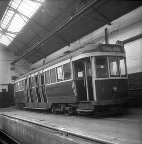
Negative, Wal Jack collection, Sep. 1941
Black and white negative by Wal Jack? of N 123 at Coburg Tram Depot, with the destination of Coburg Depot. Photo dated, 9/1941 in the Wal Jack album.trams, tramways, coburg depot, n class, tram 123 -
 Ballarat Tramway Museum
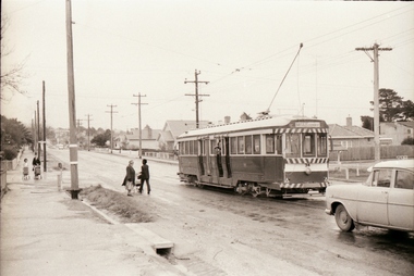
Negative - Set of 3, Campbell Duncan, 2/07/1971 12:00:00 AM
Yields information about tram operations and the street views on the Mt Pleasant line.Set of 3 photographs taken on 28/2/1971 by Campbell Duncan of trams on the Mt Pleasant line. .1 - tram - inbound - 34 to Gardens, at a rather wintry wet stop in Barkly St with passengers alighting and boarding. .2 - No. 34 at the Mt Pleasant terminus .3 - 34 inbound, soon after leaving the terminus.trams, tramways, mt pleasant, barkly st, tram 34 -
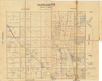 Bendigo Historical Society Inc.
Map - JACK FLYNN COLLECTION: YARRABERB, NO date visible
Map: Parish of Yarraberb, County of Bendigo. Parish plan.By Authority H.J. Green. Govt., Printer.map, bendigo, parish plan, yarraberb -
 Melbourne Tram Museum
Negative, Ellis Collection, c1933?
Negative (120) of a W2 descending the Collins St hill to Swanston St, early to mid 1930's. Tram does not appear to have been fitted with a route number box. The Manchester Unity Building was completed during 1932. Tram number appears to be 394. This was a Kew tram at the time and has the appropriate roof, but it could be another tram. Many motor vehicles in the view. Has the City of Melbourne Town Hall in the view. Hi Res image filed in the dbtext/hawthtramcoll/Large Images/htd3605Large.jpgtrams, tramways, collins st, town hall, swanston st, w2 class, tram 394? -
Bendigo Historical Society Inc.
Negative - CASTLEMAINE GAS COMPANY COLLECTION: NEGATIVES
3 strips of negative films in small paper envelope. The negatives relate to photos 11518.510 and 11518.511. These negatives have not been scanned.negative, bendigo, gas and fuel -
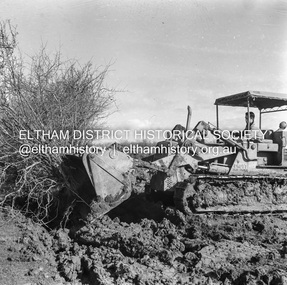
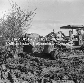 Eltham District Historical Society Inc
Negative - Photograph, J.A. McDonald, Kangaroo Ground-Queenstown Road, Aug. 1960
(Kangaroo Ground-St Andrews Road) “Rymers” Corner – shifting Hawthorn hedges on Tompkins property Council’s Drott 6 Woods Drott 9 August 1960 Showing method of lifting clumps of HawthornRecord of various Shire of Eltham infrastructure works undertaken during the period of 1952-1962 involving bridge and road reconstruction projects, sometimes with Eltham Shire Council Project Reference numbers quoted. It was during this period that a number of significant improvements were made to roads and new bridges constructed within the shire that remain in place as of present day (2022). In many situations, the photos provide a tangible visible record of infrastructure that existed throughout the early days of the Shire. The album was put together by or under the direction of the Shire Engineer, J.A. McDonald.infrastructure, shire of eltham, 1960-08, garden hill, kangaroo ground, kangaroo ground-queenstown road, kangaroo ground-st andrews road, rymers corner, bulldozer, drott -
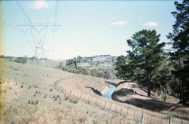 Eltham District Historical Society Inc
Negative - Photograph, Russell Yeoman, Maroondah Aqueduct, Kangaroo Ground, c.1980
Roll of 35mm colour negative film, 2 strips Colour print (x3)Kodak Safety 5035kangaroo ground, maroondah aqueduct -
 Melbourne Tram Museum
Negative, c1914
Copy negative of an illustration of cable cars in Elizabeth St at the corner with Collins St. Has the Elizabeth St station n the view, along with Craigs and the Royal Bank. Rod Atkins advised 24/08/2020: "Dates from around 1914. taken 11.53 am in high summer. The Flinders Street Railway station looks complete but we still have all the telephone cables on poles in both Elizabeth and Collins Streets. I don't know the year they all went underground. We have two standard "Fitzroy" trams in Collins Street and one West Melbourne tram with standard eight window trailer - no bogie trailers in the photo. Some of the West Melbourne trailers were still six window cars in the 1920's. The major building in the photo is the "Royal Bank" on the South East Cnr. of Collins and Elizabeth Street. "trams, tramways, cable trams, collins st, elizabeth st -
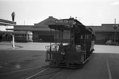 Melbourne Tram Museum
Negative, Wal Jack, 13/10/1940 12:00:00 AM
Black and white negative, by Wal Jack, of a cable tram set at the Bourke St terminus. In the background is the Spencer St station buildings and W2 269? northbound in Spencer St. The cable tram has the destination of Nicholson St. See Reg item 5056 for a similar image. Note the street light stand built into the verandah of the hotel and possibly that of Spencer St station verandah.trams, tramways, cable trams, bourke st, spencer st, w2 class, tram 269 -
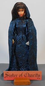 Northern District School of Nursing. Managed by Bendigo Historical Society Inc.
Education kit - Sisters of Charity Miniature Doll - Nursing through the Ages
Sisters of Charity St Vincent de Paul. In 1638 St Vincents de Paul and Mademoiselle de Gras taught simple nursing procedure to young peasant women. They worked in the home hospital and battlefield. Their duties were arduous no pain relief was known and they were exposed to infection. In the 20 century the sisters of St Vincents De Paul are working worldwide nursing teaching caring for orphans the aged lepers. They shared in advances in medical science.30cm Miniature Doll dressed in bright blue shimmering dress with matching capeName tag Sisters of Charitynursing history, nursing uniforms, northern district school of nursing, miniature dolls -
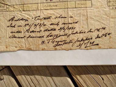
Ringwood and District Historical Society
Legal record - Conditions of Sale (C.E.Carter), Ringwood , Lot (&) on Plan of Subdivision (&), Mr Atkin and Mr Lethlian, 1942
Particulars and Conditions of Sale of Property , from Mr Atkin to Mr Lethlian. -
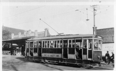 Melbourne Tram Museum
Negative, Wal Jack collection, mid 1920's
Black and White Copy Photograph of G class 50 in Glenhuntly Road with many passengers. Tram has the destination of Elsternwick. In the background is an Ironmonger's shop (W J Marsh) and a Milliner's shop and a cake and confectionary shop.trams, tramways, g class, glenhuntly rd, tram 50 -
Stawell Historical Society Inc
Map, Parish of Stawell, Sheet 5, 1958
Parish of Stawell, Sheet 5stawell -
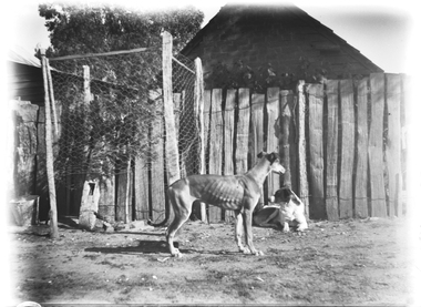 Wodonga & District Historical Society Inc
Negative - Haeusler Glass Negatives Collection - Two dogs, c1910
The Wodonga Historical Society Haeusler Collection provides invaluable insight into life in late nineteenth and early twentieth century north east Victoria. The collection comprises manuscripts, personal artefacts used by the Haeusler family on their farm in Wodonga, and a set of glass negatives which offer a unique visual snapshot of the domestic and social lives of the Haeusler family and local Wodonga community. The Haeusler family migrated from Prussia (Germany) to South Australia in the 1840s and 1850s, before purchasing 100 acres of Crown Land made available under the Victorian Lands Act 1862 (also known as ‘Duffy’s Land Act’) in 1866 in what is now Wodonga West. The Haeusler family were one of several German families to migrate from South Australia to Wodonga in the 1860s. This digital image was produced from one of the glass negatives that form part of the collection, probably taken by Louis Haeusler (b.1887) with the photographic equipment in the Wodonga Historical Society Haeusler Collection.This item is unique and has well documented provenance and a known owner. It forms part of a significant and representative historical collection which reflects the local history of Wodonga. It contributes to our understanding of domestic and family life in early twentieth century Wodonga, as well as providing interpretative capacity for themes including local history and social history.Digital image created from the Haeusler Glass negative collection. Two dogs in front of a wooden fence. The side of a house is visible behind the fence.wodonga pioneers, haeusler family, glass negatives, dry plate photography, wodonga families -
Glenelg Shire Council Cultural Collection
Negative - Glass Plate Negative - Creek scene, 1890-1910
Stereoscopic glass plate negative. Two men standing on branch of tree which has fallen over creek. -
 Bendigo Historical Society Inc.
Map - JACK FLYNN COLLECTION: VILLAGE OF BETLEY, 30/06/1874
Map: Village of Betley, on the Bet Bet Creek, Parish of Dunolly. Parish plan.Photo Lithographed at the Department of Lands and Survey Melbourne by J. Noone 30.6.74map, gladstone, village, betley, bet bet creek, dunolly -
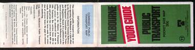 Melbourne Tram Museum
Map, Ministry of Transport, Melbourne Public Transport Map - No. 11, 1980
Map No. 11 dated on rear as 1980 - Includes description of tram and bus routes, private bus routes. Has contact details for bookings and lost property etc and how to use the map. Yields information about Melbourne public transport services in 1980Fold out map (27 sections 9 across x 3 deep), "Public Transport Map", coloured of Melbourne's Tram and Bus routes, route numbers, rail lines, detailed for the central part of Melbourne and the outer Metropolitan services.tramways, melbourne, tram services, bus services, railways, maps -
 Peterborough History Group
Map - Map of Peterborough House 1921, 1921
This hand drawn map of the buildings and out buildings was done for insurance purposes. It indicates which buildings are covered and which are uninsured. Significant as it shows a plan of the hotel as it was in 1921. Each building is labelled by its purpose, which provides an interesting insight into holidays of the time. For example, 'sleep outs' and external bathrooms. A4 photocopy of a hand drawn map of the buildings and out buildings comprising Peterborough House. Hand drawn map -
 Eltham District Historical Society Inc
Negative - Photograph, J.A. McDonald, Kangaroo Ground-Queenstown Road, Aug. 1960
(Kangaroo Ground-St Andrews Road) “Rymers” Corner – shifting Hawthorn hedges on Tompkins property Council’s Drott 6 Woods Drott 9 August 1960 Showing method of lifting clumps of HawthornRecord of various Shire of Eltham infrastructure works undertaken during the period of 1952-1962 involving bridge and road reconstruction projects, sometimes with Eltham Shire Council Project Reference numbers quoted. It was during this period that a number of significant improvements were made to roads and new bridges constructed within the shire that remain in place as of present day (2022). In many situations, the photos provide a tangible visible record of infrastructure that existed throughout the early days of the Shire. The album was put together by or under the direction of the Shire Engineer, J.A. McDonald.infrastructure, shire of eltham, 1960-08, garden hill, kangaroo ground, kangaroo ground-queenstown road, kangaroo ground-st andrews road, rymers corner, bulldozer, drott -
Bendigo Historical Society Inc.
Map - CAMPBELL COLLECTION: BENDIGO & DISTRICT MAPS, 2-2-29
Map. Wellsford, Parishes of Wellsford and Axedale. Scale 20 chains to 1 inch. Total area 4994 acres. Prepared in W.P.B. from A. and P. Plans by W.J.G. (number 377 in map cupboard 1)W.J.Galbraithmap, bendigo, country lands -
 Federation University Historical Collection
Map, Ballarat and Sebastapol Gold Mines, Late 19th Century
colored printed map on paper lined onto linen backingprinted "Rider & Mercer's Plan of the Ballarat & Sebastapol Gold Mines Scale 30 Chains to One Inch"gold mines, mine allotment map, mining leases, ballarat, sebastopol, rider and mercer, golden shaft co, prince of wales and bonshaw united, leviathan gold mines, holst and co, speedwell co, sebastopol plateau, rothschild co, tower hill co, south plateau, south star co, band of hop and albion consols, prince regent co, chenhall and co, despza, buninyong estate, one eye hully, winter's freehold, luplau plateau, e. morey, carrill's quartz -
Stawell Historical Society Inc
Map, Warra Warra, County of Borung, Shire of Stawell, 1957
Warra Warra, County of Borung, Shire of Stawellstawell -
Bendigo Historical Society Inc.
Map - SNOB'S HILL - PLAN OF SNOB'S HILL AREA
Plan drawn on tracing film of sand heap, dams, trig point and mines. Some un-named streets are also drawn in. Piece of notepaper has mines drawn in on a larger scale.map, bendigo, goldfields, snob's hill, plan of snob's hill area, new st mungo mullock heap, duchess trib, s devonshire, duchess of edinburough, w u devonshire, hopewell, phoenix, unicorn, princess alice, lady barkly, sadowa, e u devonshire, united devonshire, l?, ellenborough, belmont & saxby, snob's hill -
Whitehorse Historical Society Inc.
Map, Directory Maps of the County of Bourke, 1892
Copies of Directory maps:(i) Title Page, (ii) Preface (iii) Heading section of Map of Melbourne and Suburbs (iv) Parish of Bulleen - includes 'North - East portion of the Parish of Nunawading (v) Village of Burwood. Note: 107(a), 107(b), 107(c) are copies of the same set of sheets.Copies of:(i) Title Page, (ii) Preface (iii) Heading section of Map of Melbourne and Suburbs (iv) Parish of Bulleen - includes 'North - East portion of the Parish of Nunawading (v) Village of Burwood. Note: 107(a), 107(b), 107(c) are copies of the same set of sheets.Copies of Directory maps:(i) Title Page, (ii) Preface (iii) Heading section of Map of Melbourne and Suburbs (iv) Parish of Bulleen - includes 'North - East portion of the Parish of Nunawading (v) Village of Burwood. Note: 107(a), 107(b), 107(c) are copies of the same set of sheets.maps, parish of bulleen, parish of nunawading, burwood -
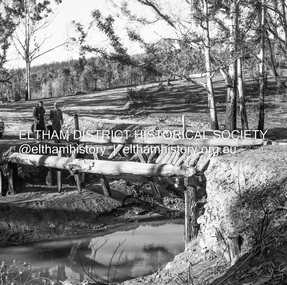 Eltham District Historical Society Inc
Negative - Photograph, J.A. McDonald, Clintons Road, Christmas Hills, 2 July 1962
Burned bridge Temporary bridge on RHS 2 July 1962 The bridge was destroyed by bushfires 15-16 January 1962Record of various Shire of Eltham infrastructure works undertaken during the period of 1952-1962 involving bridge and road reconstruction projects, sometimes with Eltham Shire Council Project Reference numbers quoted. It was during this period that a number of significant improvements were made to roads and new bridges constructed within the shire that remain in place as of present day (2022). In many situations, the photos provide a tangible visible record of infrastructure that existed throughout the early days of the Shire. The album was put together by or under the direction of the Shire Engineer, J.A. McDonald.1962-07-02, bridge construction, christmas hills, clintons road, infrastructure, shire of eltham, victorian bushfires - 1962, bush fires