-
 Glenelg Shire Council Cultural Collection
Negative - Negative - View from Henty Beach lawns Portland, Victoria, Zilah Maschmedt, c. 1934
Negative for a black and white photograph. Image shows view from Henty Beach lawns, looking towards Whaler's Bluff. Beach shelters, samd,, Railway Pier, Baths, Ocean Pier, lighthouse and water tower on Whaler's Bluff. -
 Federation University Historical Collection
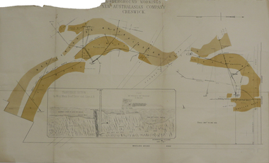
Plan, Underground Workings New Australasian Company Creswick, not dated
A plan of the underground working of the New Australasian Mine at Creswick, showing Wheeler's Bridge Road, a transverse section on the West Main Reef Drive and Line AB. It als shows the locations of the Red streak or Australasian Gutter, Reef wash, Eastern Wash, Australasian and Eaglehawk Shaft and prospecting drives.mining, plans, cgt, creswick, new australasian company, wheeler's bridge, red streak gutter, australasian gutter, reef wash, eastern wash, australiasian shaft, eaglehawk shaft -
Glenelg Shire Council Cultural Collection
Plan - Plans / Line Drawings - Port of Portland Authority Port Harbour Trust Slipway Bilge Blocks New Dolphin, Victoria, 21/09/1981
PORT OF PORTLAND AUTHORITYFront: '26' - black texta, top right corner -
 Eltham District Historical Society Inc
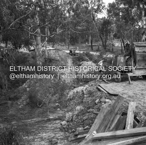
Negative - Photograph, J.A. McDonald, Henley Road at Watsons Creek, Apr. 1961
Henley Road at Watsons Creek looking easterly along centreline from west abutment Early April 1961Record of various Shire of Eltham infrastructure works undertaken during the period of 1952-1962 involving bridge and road reconstruction projects, sometimes with Eltham Shire Council Project Reference numbers quoted. It was during this period that a number of significant improvements were made to roads and new bridges constructed within the shire that remain in place as of present day (2022). In many situations, the photos provide a tangible visible record of infrastructure that existed throughout the early days of the Shire. The album was put together by or under the direction of the Shire Engineer, J.A. McDonald.infrastructure, shire of eltham, bend of islands, cr. charis pelling, henley road, henley road bridge, kangaroo ground, oxley bridge, watsons creek, w.e. wolf, bridge construction, road construction, 1961-04 -
Ringwood and District Historical Society
Legal record - Conditions of Sale (C.E.Carter), Ringwood - Crown Allotment 12, D Hodges to Unstated Purchaser - 1925
Particulars and Conditions of Sale of Property , from D Hodges to Unstated -
Ringwood and District Historical Society
Legal record - Conditions of Sale (C.E.Carter), Ringwood - Lots 98 & 99, Plan of Subdivision No 9473, J Roberts to B Tilbury & A Albon, 1925
Particulars and Conditions of Sale of Property , from John roberts to B Tilbury & A Albon -
Glenelg Shire Council Cultural Collection
Plan - Plans / Line Drawings - Port of Portland Authority, Victoria, n.d
Port of Portland AuthorityFront: '37'- black texta, top right corner -
Glenelg Shire Council Cultural Collection
Plan - Plans / Line Drawing Port of Portland Slipway Tuna Vessel 'Roza-S', c. 1986
Front: '24' - black texta, top right cornerport of portland -
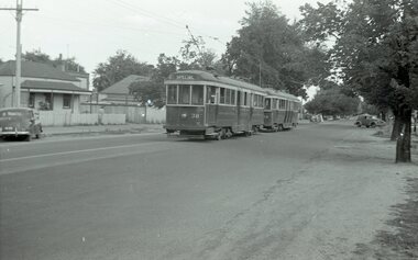
 Melbourne Tram Museum
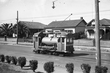
Negative, Wal Jack, 15/03/1945 12:00:00 AM
Black and white negative, by Wal Jack, of Scrubber 8 in Maribyrnong Road. Wal's album notes that the photo is near the River terminus and dated 15-3-1945.trams, tramways, maribyrnong rd, scrubber tram, work trams, tram 8 -
 Eltham District Historical Society Inc
Negative - Photograph, Probably John Street, Eltham, c.Mar. 1983
Roll of 35mm colour negative film, 4 stripsKodak Safety 5035john street, eltham, houses -
 Ballarat Tramway Museum
Negative, Wal Jack, early 1950's
Yields information about tram services possibly for a special event.Negative and Digital images of the Wal Jack Ballarat Negative file of trams 38 and 39 in Drummond St North, at Duncan St. Tram 38 showing Special. May be related to the Reg Item 7724.trams, tramways, drummond st nth, tram 38 tram 39 -
Moorabbin Air Museum
Plan (item) - C.A.C Winjeel Conversion XP75
-
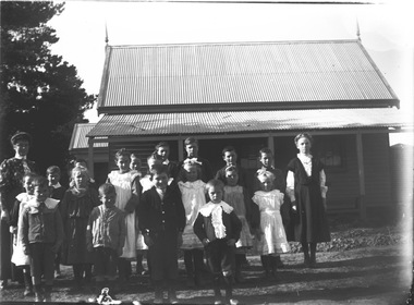 Wodonga & District Historical Society Inc
Negative - Haeusler Glass Negatives Collection - Wodonga West School and pupils, c1910
The Wodonga Historical Society Haeusler Collection provides invaluable insight into life in late nineteenth and early twentieth century north east Victoria. The collection comprises manuscripts, personal artefacts used by the Haeusler family on their farm in Wodonga, and a set of glass negatives which offer a unique visual snapshot of the domestic and social lives of the Haeusler family and local Wodonga community. The Haeusler family migrated from Prussia (Germany) to South Australia in the 1840s and 1850s, before purchasing 100 acres of Crown Land made available under the Victorian Lands Act 1862 (also known as ‘Duffy’s Land Act’) in 1866 in what is now Wodonga West. The Haeusler family were one of several German families to migrate from South Australia to Wodonga in the 1860s. This digital image was produced from one of the glass negatives that form part of the collection, probably taken by Louis Haeusler (b.1887) with the photographic equipment in the Wodonga Historical Society Haeusler Collection. This item is unique and has well documented provenance and a known owner. It forms part of a significant and representative historical collection which reflects the local history of Wodonga. It contributes to our understanding of domestic and family life in early twentieth century Wodonga, as well as providing interpretative capacity for themes including local history and social history.Digital image created from the Haeusler Glass negative collection. A group of students and their teacher standing outside Wodonga West Primary School No. 1058. C.1910. The school was located near the current intersection of McKoy Street and the Hume Freeway in West Wodonga on land donated by J.W. Klinge, replacing an older school north of the railway line. It operated from January 1870 to May 1950 when the nine remaining students transferred to Wodonga Primary School.wodonga pioneers, haeusler family, glass negatives, dry plate photography, wodonga west school -
Glenelg Shire Council Cultural Collection
Negative - Negative - Lee Breakwater under construction Portland, Victoria, Zilah Maschmedt, 1961
Negative for a black and white photograph. Image shows Lee Breakwater (SL Patterson) under construction, taken near old baths, Whaler's Bluff in background. -
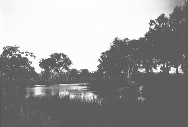 Wodonga & District Historical Society Inc
Negative - Haeusler Glass Negatives Collection - Water view near Wodonga, c1910
The Wodonga Historical Society Haeusler Collection provides invaluable insight into life in late nineteenth and early twentieth century north east Victoria. The collection comprises manuscripts, personal artefacts used by the Haeusler family on their farm in Wodonga, and a set of glass negatives which offer a unique visual snapshot of the domestic and social lives of the Haeusler family and local Wodonga community. The Haeusler family migrated from Prussia (Germany) to South Australia in the 1840s and 1850s, before purchasing 100 acres of Crown Land made available under the Victorian Lands Act 1862 (also known as ‘Duffy’s Land Act’) in 1866 in what is now Wodonga West. The Haeusler family were one of several German families to migrate from South Australia to Wodonga in the 1860s. This digital image was produced from one of the glass negatives that form part of the collection, probably taken by Louis Haeusler (b.1887) with the photographic equipment in the Wodonga Historical Society Haeusler Collection. This item is unique and has well documented provenance and a known owner. It forms part of a significant and representative historical collection which reflects the local history of Wodonga. It contributes to our understanding of domestic and family life in early twentieth century Wodonga, as well as providing interpretative capacity for themes including local history and social history.Digital image created from the Haeusler Glass negative collection. A view of water between trees near Wodonga, Victoria C. 1910wodonga pioneers, haeusler family, glass negatives, dry plate photography, wodonga -
Federation University Historical Collection
Plan, Ballarat School of Mines Botanical Garden Plan, 2016
The Ballarat School of Mines Botanic Garden was established in 1872.A PDF of a garden plan for the Ballarat School of Mines Botanical Gardenballarat school of mines botanical gardens, john patrick -
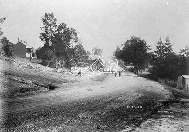 Eltham District Historical Society Inc
Negative - Photograph, Eltham, Main Road, c.1910
Eltham, Main Road. Looking south from Henry Street towards Bakery (on left), c.1910 Mrs Davis house on left - Doug Orford recalled that there was always a dog on the couch on the front verandahThis photo forms part of a collection of photographs gathered by the Shire of Eltham for their centenary project book,"Pioneers and Painters: 100 years of the Shire of Eltham" by Alan Marshall (1971). The collection of over 500 images is held in partnership between Eltham District Historical Society and Yarra Plenty Regional Library (Eltham Library) and is now formally known as the 'The Shire of Eltham Pioneers Photograph Collection.' It is significant in being the first community sourced collection representing the places and people of the Shire's first one hundred years.Digital image 4 x 5 inch B&W Neg Print 20 x 25 cmsepp, shire of eltham pioneers photograph collection, eltham, main road, bakery, henry street, mrs davis house -
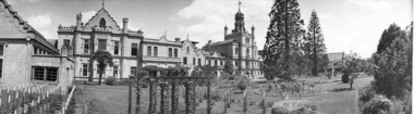 Federation University Historical Collection
Plan - Photograph - black and white, Ballarat Benevolent Asylum, 1940
The Ballarat Benevolent Asylum building as depicted in this photograph was demolished in 1941.Black and white panoramic photograph of a large building with well laid our gardens in the foreground. The property is the Ballarat Benevolent Asylumballarat, benevolent asylum, asylum, ballarat benevolent asylum, queen elizabeth benevolent asylum, garden -
 Eltham District Historical Society Inc
Negative - Photograph, J.A. McDonald, General; Shire Offices, Sep. 1959
Shire of Lilydale, 15 Anderson Street, LilydaleRecord of various Shire of Eltham infrastructure works undertaken during the period of 1952-1962 involving bridge and road reconstruction projects, sometimes with Eltham Shire Council Project Reference numbers quoted. It was during this period that a number of significant improvements were made to roads and new bridges constructed within the shire that remain in place as of present day (2022). In many situations, the photos provide a tangible visible record of infrastructure that existed throughout the early days of the Shire. The album was put together by or under the direction of the Shire Engineer, J.A. McDonald.infrastructure, 1959-09, benchmark studies, lilydale shire office, scan - 120 format 6x6 negative -
Ringwood and District Historical Society
Legal record - Conditions of Sale (C.E.Carter), Ringwood - Crown Allotment 27, Harry Peake to ?
Particulars and Conditions of Sale of Property , Harry Peake to ? Dated December 1924. -
University of Melbourne, Burnley Campus Archives
Plan, Egg Laying Competition
Copy of plan for fencing. Area bounded by potting sheds, vehicle park, tennis court and railway line.fencing, tennis court, vehicle park, egg laying, competition -
Port Melbourne Historical & Preservation Society
Plan - Proposed bridge under Hobsons Bay railway at Clarendon Street, Emerald Hill, 1854 - 1884
Plan of proposed bridge under Hobson's Bay Railway at Clarendon Street, Emerald Hill, affecting Sandridge railway and Sandridge Road. Flood level re Sandridge line is shown.transport - railways, flood, emerald hill, town planning -
Port Melbourne Historical & Preservation Society
Essay - Thesis, Competing ideas for the inner city, F Patricia Hawkins, Competing ideas for the inner city, 1991
Minor thesis submitted as part of the Master of Arts in Public History, Monash University, by Pat Hawkins, member of the PMH&PSCompeting ideas for the inner city - local responses to central planning initiatives in the City of Port Melbourne 1925 - 1985 by F Patricia Hawkins, 1991built environment, town planning, local government - city of port melbourne, f patricia (pat) hawkins -
Clunes Museum
Plan, Varley Bros, Proposed Turbine Creamery, 1894
Hand drawn plan on paperHandwritten in black ink: "These are the drawings referred to in our tender dated 7th September '94 for erection of creamery building at Glendaruel J Acrow *& Co. Contractorcreamery, turbines, plans, glendaruel, j bartram & son, varley bros -
Moorabbin Air Museum
Plan (item) - Bristol Aeroplane 170 schematic drawings, Assembly Front Spar
Bristol Aeroplane Company Ltd -
 Eltham District Historical Society Inc
Negative - Photograph, J.A. McDonald, General; Kerb Styles, Mar. 1960
Roll over kerb City of Preston March 1960Record of various Shire of Eltham infrastructure works undertaken during the period of 1952-1962 involving bridge and road reconstruction projects, sometimes with Eltham Shire Council Project Reference numbers quoted. It was during this period that a number of significant improvements were made to roads and new bridges constructed within the shire that remain in place as of present day (2022). In many situations, the photos provide a tangible visible record of infrastructure that existed throughout the early days of the Shire. The album was put together by or under the direction of the Shire Engineer, J.A. McDonald.infrastructure, 1960-03, benchmark studies, city of preston, footpaths and gutters, shire of eltham -
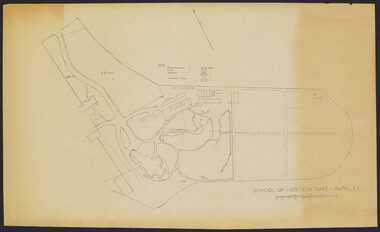 University of Melbourne, Burnley Campus Archives
Plan - Sketch, School of Horticulture - Burnley, 1957
A,B,C,E paper copies, D, tracing paper copy of plan. Hand drawn sketch of central area of grounds. Figures given for acreage of ornamentals, crops and grazing although only 1 acreage is shown on plan. (E) has further annotation. Scale 1 inch:40 ft.burnley gardens, ornmental, crops, grazing, burnley school of horticulture -
Port Melbourne Historical & Preservation Society
Plan - Bayside development, Port Melbourne, Sandridge City Development Company Pty Ltd, 14 Jun 1989
Site plan DP-1.00. Proposal plan for Bayside development incorporating Princes and Station Piers, Missions to Seamen Building (on a canal) and 2 new hotels.Lower corner of face: '500m to radio mast', '400m to radio mast'town planning - proposals shelved - bayside, sandridge city development co pty ltd, scdc -
Ringwood and District Historical Society
Legal record - Conditions of Sale (C.E.Carter), Ringwood East - Crown Allotments 35 & 36 - R. Davidson to Mrs J. A. E. Tudman. 1926
Particulars and Conditions of Sale of Property , from Robert Davidson to Jessie Tudman -
 Eltham District Historical Society Inc
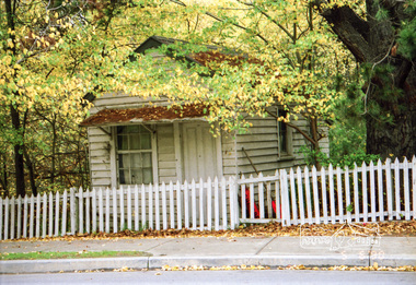
Negative - Photograph, Bootmaker's shop adjacent to Whitecloud Cottage, 701 Main Road, Eltham, 5 June 1990
One of only three remaining early 20th century shops in the former Little Eltham district. The bootmaker's shop was operated by John Henry (Harry) Clark from about 1930. Clark was originally a photographer along with his brothers William (Will) Charles Clark and Clement Kent Clark. They operated as Clark Bros Photographers based at 25 Thomas Street, Windsor (Prahran) from about 1895 to 1915 at which point the premises was demolished.. Brother Clement died in 1912. From about 1910 Harry was living and working as a photographer in Eltham and was recorded on the electoral rolls as a photographer from 1915 up to and including at least 1928. He boarded with Thekla Jarrold and the Jarrold family in the Jarrold family cottage (Whitecloud). By 1931 he changed his profession to Bootmaker and Thekla Jarrold built him this litrtle shop circa 1930 on the corner of her property next to the family home. He was well regarded by all as a fine leather worker and operated as a Bootmaker from his little shop at least until 1954. He died at St Vincent'e Hospital in Dec 1956. Very little public record exists of Harry in the papers either as a photographer or bootmaker, one incident was reported in 1935 when he witnessed a girl on a bike come crashing down Dalton Street and across Main Road into the pond next to his shop. ELTHAM GIRL THROWN FROM CYCLE (1935, April 26). Advertiser (Hurstbridge, Vic. : 1922 - 1939), p. 1. Retrieved September 21, 2021, from http://nla.gov.au/nla.news-article56838786 Another reference is recorded in 1932 when Council proposed to drain the adjacent pond due to complaints about mosquitoes. Both Harry and Thekla objected to the proposal. The paper reported that Thekla had lived there for 39 years at the time and Harry for 22 withoiut any cause for concern about the pond.Roll of 35mm colour negative film, 7 strips And associated colour print 10 x 15 cmFuji 200 Aeltham, buildings, houses, main road, bootmakers cottage, bootmakers, dalton street, white cloud cottage, jarrold, whitecloud cottage, jarrold cottage, jarrold property