-
 Kew Historical Society Inc
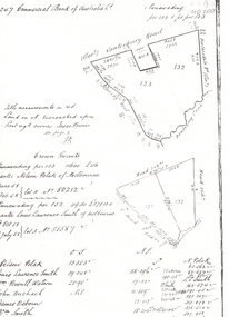
Plan, Melbourne & Metropolitan Board of Works : Borough of Kew : Detail Plan No.1571, 1904
The Melbourne and Metropolitan Board of Works (MMBW) plans were produced from the 1890s to the 1950s. They were crucial to the design and development of Melbourne's sewerage and drainage system. The plans, at a scale of 40 feet to 1 inch (1:480), provide a detailed historical record of Melbourne streetscapes and environmental features. Each plan covers one or two street blocks (roughly six streets), showing details of buildings, including garden layouts and ownership boundaries, and features such as laneways, drains, bridges, parks, municipal boundaries and other prominent landmarks as they existed at the time each plan was produced. (Source: State Library of Victoria)This plan forms part of a large group of MMBW plans and maps that was donated to the Society by the Mr Poulter, City Engineer of the City of Kew in 1989. Within this collection, thirty-five hand-coloured plans, backed with linen, are of statewide significance as they include annotations that provide details of construction materials used in buildings in the first decade of the 20th century as well as additional information about land ownership and usage. The copies in the Public Record Office Victoria and the State Library of Victoria are monochrome versions which do not denote building materials so that the maps in this collection are invaluable and unique tools for researchers and heritage consultants. A number of the plans are not held in the collection of the State Library of Victoria so they have the additional attribute of rarity.Original survey plan, issued by the MMBW to a contractor with responsibility for constructing sewers in the area identified on the plan within the Borough of Kew. The plan was at some stage hand-coloured, possibly by the contractor, but more likely by officers working in the Engineering Department of the Borough and later Town, then City of Kew. The hand-coloured sections of buildings on the plan were used to denote masonry or brick constructions (pink), weatherboard constructions (yellow), and public buildings (grey). This plan is the other half of Plan No.1571 representing the constructions to the west of Wellington Street before and in 1903/4. This plan represents the built environment in Edgevale Road, Wellington Street, Atkins Street, Annadale Street, Mortimer Street, and Cotham Road. Whereas there are smaller allotments and more modest housing stock facing Edgevale Road, larger blocks and more substantial houses are represented facing Cotham Road.melbourne and metropolitan board of works, detail plans, mmbw 1571, cartography -
 Whitehorse Historical Society Inc.
Legal record - Land Title, Crown grant, 1858
Commercial Bank of Australia record of Crown Grants of land to Nelson Polak and Louis Laurence Smith in 1858.Commercial Bank of Australia record of Crown Grants of land to Nelson Polak and Louis Laurence Smith in 1858. The land is between Canterbury Road, Heatherdale Road, 'Scoresby Road' (now Boronia Road) and the Dandenong Creek.Commercial Bank of Australia record of Crown Grants of land to Nelson Polak and Louis Laurence Smith in 1858. polak, nelson, smith, l l dr, canterbury road, vermont, boronia road, dandenong creek, heatherdale road, land sales -
 Clunes Museum
Legal record - BINDER - BANK OF AUSTRALASIA, 1955 - 1956
BROWN SYNTHETIC BINDER - THE BANK OF AUSTRALASIA - CONTAINING STATEMENTS CLUNES LADIES BENEVOLENT SOCIETY 16 - 5 - 1955 TO 15 - 3 - 1956commerce, banking, benevolent society, clunes hospital -
 University of Melbourne, Burnley Campus Archives
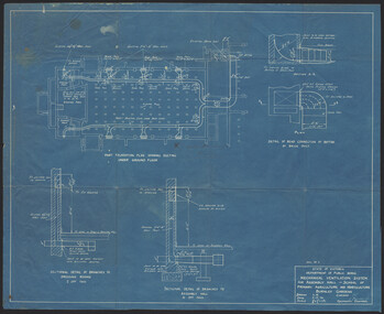
Plan, K.O. Wood, Mechanical Ventilation System, 1946
Blue print of mechanical ventilation system for Assembly Hall by K.O. Wood, Mechanical Engineer. Dated 9.7.'46.k.o. wood, mechanical engineer, ventilation -
 Bendigo Historical Society Inc.
Legal record - Letter Book
Letter Book with alphabetised index for the duration 3/06/1872 to 15/10/1872 - not attributed to any organisation / office (more research required). Register covers assigned letter number and brief description registered as 72/2028 to 72/5689 (over pages 3 to 444), handwritten in black ink. Letters cover a broad range of topics / responses such a "no objection". Green heavy card covers with red faux leather spine and worn corners.Spine marked Letter Book, 3/06/1872 to 15/10/1872.letter book, solicitor -
Port Melbourne Historical & Preservation Society
Essay - Thesis, The 1928 Waterfront Strike, Liam Brooks, "The 1928 Waterfront Strike"
CD of thesis entitled "The 1928 Waterfront Strike"by Liam Brooks. Hard copy stored A .08.03piers and wharves - princes pier, societies clubs unions and other organisations, liam brooks, e j hogan, thomas blamey, allan whittaker, waterside workers union -
University of Melbourne, Burnley Campus Archives
Plan - Photocopy, Plan Research Institute, 1986-1989
Donated by Emma Ferguson and Jo van Berkel for their Oct 1994 Thesis.Photocopy of site plan of the Victorian College of Agriculture and Horticulture. Scale 1:500. Overall plan of garden with main buildings and gardens named. (Also see B11.0711 and B11.0715 for the same plan.)Note on reverse, "Not from Archives."victorian college of agriculture and horticulture, research institute, emma ferguson, jo van berkel -
Port Melbourne Historical & Preservation Society
Plan - Visit of HMY Britannia, Inner East berth, Station Pier, Port Melbourne, Melbourne Harbor Trust, 16 Mar 1977
Plan - Layout arrangement for visit of H.M.Y. Britannia, Inner East Station Pier 16-3-1977.melbourne harbor trust - port of melbourne authority, royal visits and occasions, piers and wharves - station pier -
Ringwood and District Historical Society
Legal record - Conditions of Sale (C.E. Carter), Ringwood Electric Railway Estate, Lots 98 and 99, Sale to Tilbury and Albon, 1925
Original Particulars and Conditions of Sale document by C.E. Carter & F. H. Patterson & Co, to B.C. Tilbury Esq and A.J.Albon Esq: Lots 98 and 99, Electric Railway estate, Ringwood Plan of Subdivision 9473, Crown Portion 18, Parish of Ringwood. -
Ringwood and District Historical Society
Legal record - Conditions of Sale (C.E.Carter), Mitcham - Crown Allotment 124. M.E.Burke to ? Dated June 1st 1929
Particulars and Conditions of Sale of Property , Lot 44 and 45 on Plan of Subdivision 6736, Mitcham Road, Mitcham. Mrs M.E.Burke to ? -
University of Melbourne, Burnley Campus Archives
Plan, Kate Blood, City of Werribee Proposal for a Monument to Mark the Proclamation of Werribee as a City, 1987
Coloured elevation by Kate Blood dated 16.04.1987kate blood, werribee -
 Vision Australia
Plan - Image, Conversion to Administrative offices / Conversion to Rehabilitation centre, 1 November 1962 - 5 April 1963
Over 1962-63, plans were drawn up for the conversion of the main building into administrative offices and a rehabilitation centre. As the children were now located at the school in Burwood, and with funds achieved from the sale of the old factory buildings to the Alfred Hospital, the St Kilda Road building could expand room for its office workers and provide greater floor space to rehabilitation staff. These plans show the proposed conversion from bedrooms to administrative and rehabilitation areas.7 architectural plans and 1 letterJohn F D Scarborough and Partners, Architectsroyal victorian institute for the blind, plans -
Bialik College
Plan (Item) - Bialik College Site Plan no date
no date, likely post-2019 due to ELC presencejudaism, bialik college, 2000 -
Glenelg Shire Council Cultural Collection
Plan - Plan - subdivision at Cape Bridgewater, n.d
Black and white photocopy of a 1990s plan of a subdivision at Cape Bridgewater - 'Heritage Valley'. Twenty-eight lots . In two halves, not joined togethertown planning, residential, sub divide, cape bridgewater -
Glenelg Shire Council Cultural Collection
Plan - Plans - Port of Portland Slipway - Steel Trawler 'Aqua Enterprise', 02/10/1980
PORT OF PORTLAND AUTHORITYFront: '18' - black texta, top right corner -
 Federation University Historical Collection
Plan, Burrumbeep, 1884, 16/10/1884
Auctions of Crown land were introduced in the Colony of Victoria from 1851 to encourage settlers to occupy and work the land. Many squatters purchased land at auction at the upset (minimum) price of £1 per acre. In some areas where demand was high, such as the goldfields, the price realised at auction was much more. Land was put up for sale in the study area on the Burrumbeep run in May 1855, on the Lexington run in 1857, and on the Gorrinn run in 1858. (http://www.ararat.vic.gov.au/library/document/thermatics.pdf, accessed 27 January 2015) For 70 years or more, Yalla-y-Poora, Burrumbeep, Edgarley, Mount William and Narrapumelap ranked in the leading wool producers in Victoria. 1 Stud owners at Yalla-y-Poora, Eurambeen, Burrumbeep and Challicum crossed merino sheep with sheep descended from John Macarthur's Camden Park in New South Wales. (http://www.ararat.vic.gov.au/library/document/thermatics.pdf, accessed 27 January 2015) In what was to become the Ararat Mining Division, gold was discovered in May 1854 on the Burrumbeep run at a place that became known as Pinky Point on the Mount William goldfield. By 21 June 1854, between 600 and 1,000 people had arrived. (http://www.ararat.vic.gov.au/library/document/thermatics.pdf, accessed 27 January 2015)\ Town allotment plan for Burrumbeep. Merrymbuela, Borung, Lexington and Langi Logan are neighbouring areas. The plan includes the Burrumbeep Pre-Emptive Right (Roger and Wright); licensed land holders including Stephen Young, John Carroll, William Walsh, Thomas Purcell, Martha M. Bond, Colin Johnson, John Charles Webb, Henry Withycombe, William Henry Barbridge, John Wall, Thomas Flatelly, William Jenkinson, Elisia Radford, V. Radford, Denis Byrne, George Cook. Land holders included Andrew Maloney, Richard Wingfield Harrocks, W. Sporton, Terence Lynch, F. S. Falkiner, A. Millman, H. Morris, George Upham, J. McCLure, S. Fletcher, W. Parker, Thomas Myers, William wright, W.C. Winter, C. Wordman, Oliver A. Winter This plan is associated with former Ballarat School of Mines student Richard Squire (1875-6) Gift of the Squire FamilyVerso written in pencil - Plan of Burrembeep Ararat Burrembeep Araratburrumbeep, corrinn, langi logan, merrymbuela, lexington, ararat, roger & wright, cook, rogers, upham, george upham, ross, parsans, morris, johnson, withycoombe, colin johnson, falkiner, dsporton, john carroll, donald gordon, denis bryne, maurice dooley, martha bond, william harricks, \william wingfield harricks, william l.c. harricks, michael houlihan, thomas purcell, martin ryan, michael cody, fletcher, mccaw, w. parker, j.m. clow, elisia radford, thomas radford, thomas myers, barbridge, e. wilde, j. wall, flatelly, g. wardman, w.c. winter, david ball, jenkinson, ballarat school of mines, richard squire, squire -
Ballarat Tramway Museum
Legal Record - Legal Document, State Electricity Commission of Victoria (SECV), "Extract from ACT No. 3776"
Single page giving an "Extract from ACT No. 3776 - An Act to consolidate the Law relating to the State Electricity Commission of Victoria and the Power and Duties thereof" - 1928. Gives an extract from page 11, "Provisions relating to Councils and Other Undertakers." Carbon copy of the report typed onto paper with rounded corners.trams, tramways, sec, acts of parliament, power supply, councils -
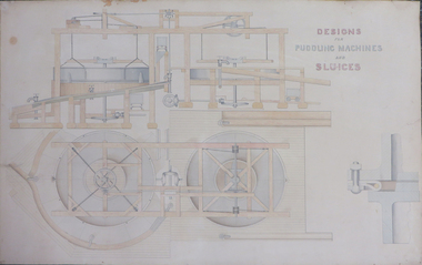 Federation University Historical Collection
Plan, Designs for Puddling Machines and Sluices
Hand Drawn and coloured design for puddling machines and Sluices. puddling machine, sluicing machine -
Ballarat Tramway Museum
Legal record - Legal Document, Ballarat Tramway Preservation Society (BTPS), "Memorandum & Articles of Association of the BTPS, 1971 late
31 page document on foolscap paper, duplicated. Draft Memorandum and Articles of Association for the BTPS to enable the organisation to be registered under the Companies Act 1961. Actual document not adopted and signed by subscribers until 24/8/1973. Final document based heavily on this document. This document drew heavily on the ARHS Vic. Div. Articles. Has staple in top left hand corner. Printed onto duplicator paper.In top left hand corner, in a box is "GCN 9-1-72", indicating a copy that George Netherway received on 9/1/1972.trams, tramways, btps, rules, memorandum of association, incorporation -
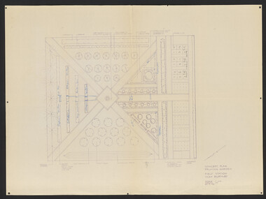 University of Melbourne, Burnley Campus Archives
Plan, Pruning Garden, 1985-1995
Set of Concept Plans for the design of a Pruning Garden in the Field Station. (1) Pencil drawing on tracing paper, "Pruning Garden Field Station." (2) On tracing paper, "Concept Plan Pruning Garden Field Station VCAH Burnley 25.03.1995 by "JK". (3) 3 copies of (2) on paper. (4) 4 reduced size copies with some annotation. (5) Typed list, "Plants for Pruning Garden." (6) Tracing paper copy, Pruning Garden VCAH Burnley, Aug 1985. Scale 1: (7) Hard copy of (6).pruning, field station, vcah, burnley, gardens -
Glenelg Shire Council Cultural Collection
Plan - Plans / Line drawings - Port of Portland Authority, Portland Harbour Trust Commissioners Fishermen's breakwater, Victoria, 05/03/1974
PORT OF PORTLAND AUTHORITYFront: '3' black texta, top right corner -
Glenelg Shire Council Cultural Collection
Plan - Plan - Port of Portland Authority slipway, 29/10/2010
Front: '19' - black texta, top right cornerport of portland -
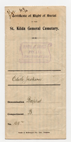 St Kilda Historical Society
Legal record - Certificate, Certificate of Right of Burial in the St Kilda General Cemetery, 1929
Certificate showing that, upon payment of 10 pounds, Edith Jackson was granted a plot number 165a in the Baptist section of the St Kilda General Cemetery, on 14 February 1929.White paper, discoloured with age, printed and handwritten on both sides in black. Red wax seal attached.st kilda cemetery, edith jackson -
Bialik College
Plan (item) - Bialik College, 1970s
Two boxes of architectural plans of proposed Bialik College, 429 Auburn Road, Hawthorn East, created by architects Joshua and Mary Pila, c. 1970s. Box 1: 1970s, Box 2: 1979. Please contact [email protected] to request access to this record.1970s, building and planning -
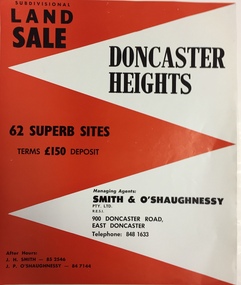 Kew Historical Society Inc
Plan - Subdivision Plan, Doncaster Heights
Real estate brochure produced for Smith & O'Shaughnessy of 900 Doncaster Road for the sale of the '65 superb sites' in the Doncaster Heights Estate. Streets with lots for sale include: Church Road, Norfolk Circuit, and Hampshire Road.Historic subdivision planFour-page colour real estate brochure issued for the sale of the Doncaster Heights Estate. The inside pages include a street plan with the numbered lots.subdivision plans - doncaster, doncaster heights estate -
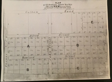 Kew Historical Society Inc
Plan - Subdivision Plan, Plan of 68 beautifully situated villa sites: St Helliers Kew, 196-1973
This work forms part of the collection assembled by the historian Dorothy Rogers, that was donated to the Kew Historical Society by her son John Rogers in 2015. The manuscripts, photographs, maps, and documents were sourced by her from both family and local collections or produced as references for her print publications. Many were directly used by Rogers in writing ‘Lovely Old Homes of Kew’ (1961) and 'A History of Kew' (1973), or the numerous articles on local history that she produced for suburban newspapers. Most of the photographs in the collection include detailed annotations in her hand. The Rogers Collection provides a comprehensive insight into the working habits of a historian in the 1960s and 1970s. Together it forms the largest privately-donated collection within the archives of the Kew Historical Society.A photographic reproduction of a plan in the Vale Collection of the State Library of Victoria. The plan shows lots in a subdivision bordered by Cotham Road; Edward Street; Sackville Street and Thomas Street. The undated plan does not include the land occupied by Bella Vista and Charleville.subdivision plans -- kew (vic), st helliers estate -
Clunes Museum
Plan - PLANS, Harry E Sando, Borough of Clunes Contract 96.6 of 1893/4, c1894
Harry E Sando C.E. (Borough Enginee) as at 10th March 1894, this plan also signed by the contactor and witness, both signatures are illegibleColoured drawings on tracing/architects papers, pinned with dress makers pins to stiff paper. Scale 2 feet to 1 inchHeadings on plans; "Ground Plan No.1, Ground Plan No.2, Sections of weirscreswick creek, flood mitigation, weir system -
 Federation University Historical Collection
Plan, Ballarat School of Mines Plans for Welding Additions
ballarat school of mines, buildings, g.d. & n.e. hewitt -
 City of Moorabbin Historical Society (Operating the Box Cottage Museum)
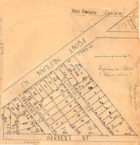
Plan - Highlands Estate, Moorabbin
The train line from the city to Frankston was electrified in 1922 which intensified the sale in the municipality of Moorabbin, particularly land which was in the vicinity of the railway stations. This estate was auctioned on Saturday, October 20, 1923.Example of the progress of the Municipality of MoorabbinAdvertising flyer for auction of real estate sales - plan of building blocks for saleHighlands Estate, Moorabbin plan.point nepean road (nepean highway), schofield street, taverner street, herbert street (now linton street), moorabbin, real estate, auction -
Ringwood and District Historical Society
Legal record - Conditions of Sale (C.E.Carter), Ringwood - Crown Portion 5, E Kennedy to D.A.Hunt - 1929
Particulars and Conditions of Sale of Property , from Edward Kennedy to Mr D. A. Hunt