Showing 4081 items
matching documentation
-
 Bendigo Historical Society Inc.
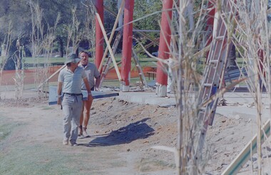
Negative - BENDIGO CHINESE TEA HOUSE
Construction of the Tea House, Nolan Street, Bendigo. Along side Lake Weeroona.buildings, commercial, tea house -
 Melbourne Tram Museum
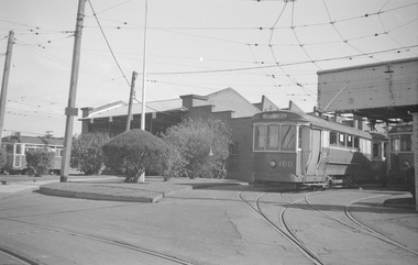
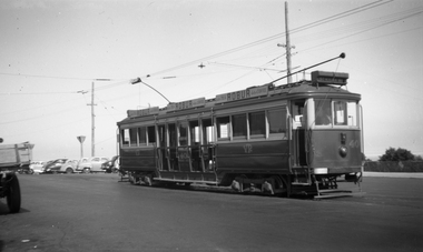
Negative, Ellis Collection, c1940
Negative (120) of a view of S Class 160 (destination Thornbury) with 161 behind and other trams at the Thornbury depot 1953. Other un-identified trams are in the view. A low resolution A4 laminated was received with the negatives. Hi Res image filed in the dbtext/hawthtramcoll/Large Images/htd3587large.jpgtrams, tramways, s class, thornbury, thornbury depot, tram 160, tram 161 -
 Eltham District Historical Society Inc
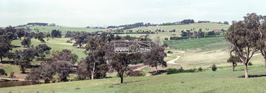
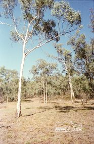
Negative - Photograph, Looking northeast from Eltham-Yarra Glen Road, Kangaroo Ground, 1998c
Roll of 35mm colour negative film, 8 strips and associated 10 x 15 cm colour printKodak Gold 100-5eltham-yarra glen road, kangaroo ground -
 Ballarat Tramway Museum
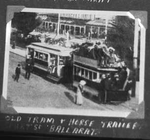
Negative - Copy, Electric Supply Co. of Vic (ESCo)
Yields information about Ballarat 's first trams - electric trams towing trailers. Better sources of image held within files. Shows crowded nature of the tram,Copy negative of a black and white photograph from Ray Pearson Collection, taken by Dave Macartney in 1975c of f an ESCo tram towing a heavily loaded ex horse tram as a trailer, eastbound along the north side of Sturt St. with the Town Hall in the background. Many people and a number of horse drawn vehicles in the photograph. Photo taken soon after opening it would appear, as a destination box on the electric tram is not visible. For a list and description of the same base image see Archives file - "Notes on ESCo Tram towing a heavily loaded trailer" Original negative held in the negative file. Laser print of scanned image in box 01-01-77. Scanned at 2100 dpi and Photoshopped for file image. See Reg Item 162 for the original postcard.trams, tramways, esco, sturt st, trailers -
 Melbourne Tram Museum
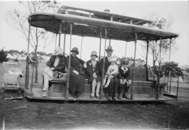
Negative, Ellis Collection, 1930s
Negative (120) of a Grip car body in a park with a family sitting on the tram. Could be the Ellis family. Caption to donation sheet says Edwards Lake, Reservoir late 1930's. See image htd3621i1 and i2 for an image of Inspector Ellis.trams, tramways, cable trams, edwards lake, grip tram, reservoir, tram 394? -
 Eltham District Historical Society Inc
Negative - Photograph, No. 1 Creek, Kinglake, c.1916
This photo forms part of a collection of photographs gathered by the Shire of Eltham for their centenary project book,"Pioneers and Painters: 100 years of the Shire of Eltham" by Alan Marshall (1971). The collection of over 500 images is held in partnership between Eltham District Historical Society and Yarra Plenty Regional Library (Eltham Library) and is now formally known as the 'The Shire of Eltham Pioneers Photograph Collection.' It is significant in being the first community sourced collection representing the places and people of the Shire's first one hundred years.Digital image 4 x 5 inch B&W Negshire of eltham pioneers photograph collection, kinglake, kinglake national park, no. 1 creek -
 Melbourne Tram Museum
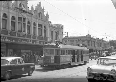
Negative, Travis Jeffrey, c1959
Negative of tram 319 at a tram stop in Church St at Swan St Richmond. Tram has destination City and Route No 77.Paper folder that contained the negative had "NR12A" in red ink, "M5" in pencil, 12A in blue ink, date stamp "29 Nov 1959" on front.trams, tramways, w2 class, route 77, church st, richmond, tram 319, overhead -
 Eltham District Historical Society Inc
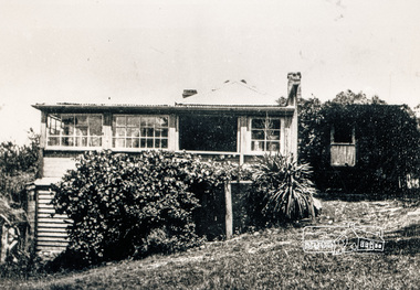
Negative - Photograph, Osborne family home, Warrandyte, c.1909
Negative copy of an orifginal print of Ethel Osborne photosNegative black and white film 120 6x9 format 2 stripsFuji Safety Neopan SSwarrandyte, audrey cahn, audrey osborne, ethel osborne, houses, audrey josephine cahn (nee osborne), ethel elizabeth osborne (nee goodson) -
 Eltham District Historical Society Inc
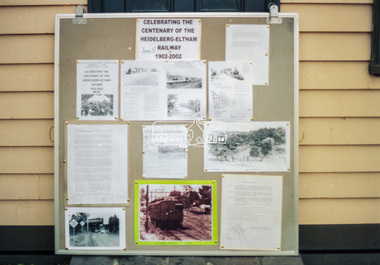
Negative - Photograph, Harry Gilham, Display celebrating the Centenary of the Heidelberg-Eltham Railway 1902-2002, Local History Centre, 728 Main Road, Eltham, c.Apr 2002
One of two display panels prepared by Eltham District Historical Society for display in the Eltham Railway Station foyer on 5 June 2002 along with handouts explaining the significance of the occassion to train passengers. In addition, Harry Gilham presented a talk on the history of the railway at the Sociiety's May 8th meeting.728 main road, activists, centenary celebrations, display, display panel, eltham district historical society, heidelberg-eltham railway extension, local history centre, lockup -
 Federation University Historical Collection
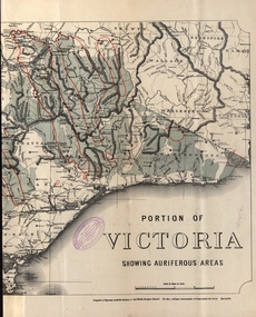
Map - Map and Information, Department of Mines: Map and Suggestions to Prospectors, 1891
The map outlines the auriferous (gold bearing) areas in Victoria. The information for prospectors was prepared by the Department of Mines in 1894Document: 4 page type written Map: Portion of Victoria divided into Counties of 1891. Auriferous areas with red.Reference section on mapgold, auriferous areas, department of mines, victoria, map of victoria, prospectors, commissioner of crown lands, hon a mclean, alexander black, surveyor general, a mclean -
 Ballarat Tramway Museum
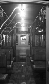
Negative, Wal Jack, 1951
Yields information about tram 23 and its internal appearance with the internal flip over backed seats.Negative and Digital images of the Wal Jack Ballarat Negative file of the interior of Ballarat 23, possibly after it has been withdrawn from service. Shows the interior former Adelaide tip over seats, Brill-Winner type seating. See btm7873doc.pdf for a series of emails from Warrington Cameron 7/2020 identifying and discussing the photograph.trams, tramways, interiors, ballarat depot, gold, centenary of gold, tram 23 -
 Bendigo Historical Society Inc.
Map - KAMAROOKA : COUNTY OF BENDIGO, 29-8-21
Map. Kamarooka, County of Bendigo, Milloo, Warragamba, Minto, Whirrakee, Tandarra, Piccaninny Creek, Dingee. By authority A.J. Mullett, Govt. Printer. Photo-Lithographed at the Department of Lands and Survey, Melbourne by W.J. Butson 29-8-21. Price 1/-. (number 63 in map cupboard 1)A.J. Mullett, Govt.Printermap, bendigo, kamarooka -
Bendigo Historical Society Inc.
Map - K. K. MINE - TRANSVERSE SECTION K. K. MINE
Transverse Section of the K. K. Mine on the Hustler's Line of Reefs, Bulletin No 33, Plate No XXXII. Map shows the different levels and their depth. Also the different types of stone encountered and geological features such as spurs and faults. Has drawing of the poppet legs at the top of the shaft and sill of shaft 773.56 ft above sea level.Map has Geological Survey of Victoria crest and signed by H S Whitelaw, Underground Survey Office Bendigo, September, 1913. This item has not been scanned or photographed.cottage, miners, fortuna hustler's mine, transverse section of k. k. mine, hustler's line of reefs, geological survey of victoria, h s whitelaw -
 Federation University Historical Collection
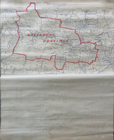
Map, Ballarat Municipalities and City Boundary
Piece of linen attached at top and bottom with wooden rails. Top half of linen has a paper map of Ballaarat Province and Surrounding Municipalities directly attached to it and reads 'Ballaarat Province' in red ink which outlines the greater Ballarat area with surrounding municipalities shown in blue. Scale is '8 miles to 1 inch'. Bottom half is drawn directly onto linen and depicts Ballaarat City Boundary including street names. 'Scale about 20 chains to 1 inch'.ballarat electorate, map, ballaarat province, ballarat to buninyong railway -
 Eltham District Historical Society Inc
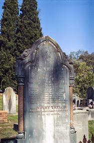
Negative - Photograph, Harry Gilham, Grave of Abraham and Ann Taylor, also Mary Taylor, Eltham Cemetery, Victoria, Sep 2009
Abraham Taylor was born 20 October 1811 in Derrycarn, Drumcree Parish, County Armagh, Ireland, the son of Richard William Taylor and Annie Abraham. He married Ann McClelland on 19 February 1852 in Dumcree. They emigrated to Australia arriving in Geelong aboard the Ann Thompson on Christmas Day, 1852. His younger sisters Mary and Martha and brother William John all having separately preceded them in 1851 and 1852. Abraham and Ann settled in Little Eltham, Abraham was recorded as being 40 years of age and Ann, 36. They made their home and living as an orchardist and gardener where they had three sons, William John (1853 Little Eltham), Richard (1855 Eltham) and Robert David (1857 Eltham), tow of whom became Councillors of the Shire of Eltham; William (1890-1911) and Robert David (1911-1920). In June 1871, Abraham Taylor, Eltham gardener, applied for a 120-acre allotment half a mile northeast of the Research Gully Hotel on June 30, 1871. A license was issued to him January 30, 1872, for 114 acres, being Allotment 8, Section 18, the balance of 6 acres being retained for reserve. He built on the land a two roomed dwelling of slabs and palings. He and his family lived there or at their 6 ½ acre Eltham property, which was used for orchard and garden as a residence. In January 1875 a lease issued to Abraham Taylor for the land one chain wide each side at the gully named ‘Wet Gully’ was excluded. In August 1881 Abraham Taylor paid up all fees and applied for a Crown grant. He vainly requested that the grant be issued to his son, Robert David Taylor, Eltham however the grant was in fact issued to Abraham Taylor, Eltham, gardener. Abraham died at home on June 1, 1890. He was greatly respected by all who knew him. His sister Mary predeceased him 1873and is also buried at Eltham cemetery. Wife Ann died at home 1 September, 1893 and was buried with him. In Loving Remembrance of Abraham Taylor Who died June 1st 1890 Aged 80 years Also Ann Taylor Wife of the above Who died September 1st 1893 Aged 75 years Also Mary Taylor Who died September 22nd 1873 Aged 45 yearsRoll of 35mm colour negative film, 6 stripsKodak GC 400-9eltham cemetery, gravestones, abraham taylor, ann taylor, mary taylor -
Bendigo Historical Society Inc.
Map - CITY OF SANDHURST RESURVEY SHEET NO. 3, 13/05/1881
Map: City of Sandhurst Resurvey sheet No. 3. Parish plan.map, bendigo, parish plan, sandhurst, resurvey -
 Eltham District Historical Society Inc
Negative - Photograph, Hohne's Hill, opposite Eltham Lower Park, c.Mar. 1983
Roll of 35mm colour negative film, 4 stripsKodak Safety 5035eltham lower park, hohnes reserve -
University of Melbourne, Burnley Campus Archives
Essay - Student Work, Leigh Stone, Assignment 4 Arboricultural Project, 02.11.1994
arboriculture, assignment, associate diploma of applied science (horticulture), ulmus, elm, elm leaf beetle -
 Eltham District Historical Society Inc
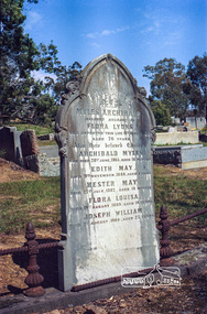
Negative - Photograph, Harry Gilham, Grave of Myles Archibald Lyons and children, Eltham Cemetery, Victoria, Sep 2009
In 1872 Senior Constable Myles Lyons replaced Peter Lawlor at Eltham Police Station. Earlier in his career, he had taken part in a search (one of many) for missing explorers Burke and Wills. At Eltham, his arrests ranged from minor instances of theft, vandalism and larrikinism to serious cases of manslaughter, murder and attempted suicide. He even tracked down and arrested two Norwegian seamen charged with desertion from their vessel. While conveying a prisoner from Eltham to Melbourne in 1886, he was attacked by the prisoner en route. It seems that much of the local news in the Evelyn Observer was provided by Eltham Shire Secretary C.S. Wingrove. In 1878, Eltham residents held an “Indignation Meeting” at the Evelyn Hotel, complaining that the reporting had denigrated Lyons’ conduct and had stigmatised the character of Eltham’s inhabitants. They passed a resolution castigating Wingrove and supporting Lyons. Wingrove claimed to have been misconstrued. But in 1887 the Evelyn Observer carried a long ranting vitriolic editorial. It complained about inadequate policing generally, then attacked Lyons personally, saying that (although efficient in the past) he had now become incompetent and needed to be replaced by a younger more energetic man. Myles Lyons retired due to ill health in 1889 but remained in Eltham until his death in 1899. He is buried in Eltham Cemetery with his wife Flora and five of their children. Four sons moved to Western Australia where two were killed in unconnected railway accidents. In Loving Memory of Myles Archibald Beloved Husband of Flora Lyons Who Departed This Life 19th August 1899 Also their beloved Children Archibald Myles Myles died at age 75 on the same day as his 14 year old daughter, Flora Louise. Who died 28th June 1865, aged 18 months Edith May Died 9th November, 1884, aged 1 year Hester May Died 17th July, 1887, Aged 14 months Flora Louisa Died 19th August, 1889, aged 14 years Joseph William Died 1st August, 1904, aged 27 yearsRoll of 35mm colour negative film, 6 stripsKodak GC 400-9eltham cemetery, gravestones, edith may lyons, flora louisa lyons, flora lyons, hester may lyons, joseph william lyons, myles archibald lyons, police, archibald myles lyons -
 Ballarat Tramway Museum
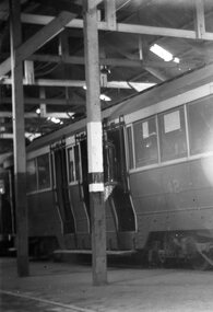
Negative, Wal Jack, mid to late 1950's
Yields information about the tram 41 in the depot.Negative and Digital image of the Wal Jack Ballarat Negative file of No. No. 42 in the depot. Shows the depot structure.trams, tramways, depot, tram 42 -
Stawell Historical Society Inc
Map, Plan of Stawell Vineyard (Bald Hills), c1896
Plan of Stawell Vineyard (Bald Hills)stawell, wine -
Bendigo Historical Society Inc.
Map - MAPPING GREAT CHANGE
DVD. Mapping Great Change. Archival Maps. Two copies. -
 Eltham District Historical Society Inc
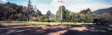
Negative - Photograph, Unidentified rural property, Eltham district, c.1985
Roll of 35mm colour negative film, 1 strip, 3 framesKodak CL200 5093driveway, infrastructure, residential, rural property, unsealed road -
Stawell Historical Society Inc
Map, Sloanes & Scotchmans Company showing underground drives, c1900
Underground Workings Mapc1900Sloanes & Scotchmans Coy mining, gold, map -
Whitehorse Historical Society Inc.
Map, Sample Plan
Sample Plan of Shireroad construction and maintenance -
 Eltham District Historical Society Inc
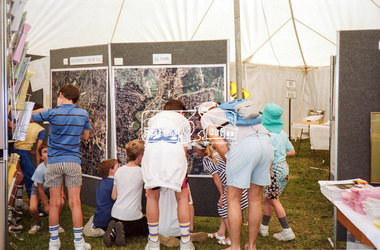
Negative - Photograph, Eltham Shire Council display, 1987 Eltham Community Festival, Alistair Knox Park, 7 Nov. 1987
Regular display by Council at the Eltham Festival providing ratepayers and visitors some insight into the daily operations of and services provided by Council and various equipment and machinery used.Roll of 35mm colour negative film, 4 stripsKodak GB 200 5096aerial photographs, alistair knox park, displays, eltham festival, eltham shire council, infrastructure, shire of eltham, briar hill, eltham, montmorency -
 Melbourne Tram Museum
Negative, Wal Jack, c1951
Black and white negative, by Wal Jack, of VR 40 at the Brighton Beach terminus. Tram has the destination of St Kilda Rly (Railway Station) and two Robur Tea/Coffee adverts on the roof.trams, tramways, brighton beach, vr trams, st kilda brighton, tram 40 -
 Eltham District Historical Society Inc
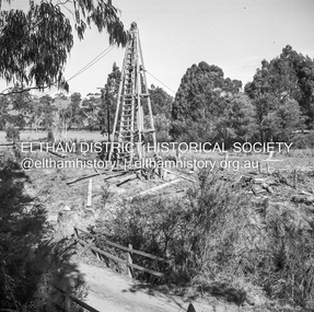
Negative - Photograph, J.A. McDonald, Laidlays Road, Arthurs Creek, April 1962
Bridge over Arthurs Creek Looking east April 1962Record of various Shire of Eltham infrastructure works undertaken during the period of 1952-1962 involving bridge and road reconstruction projects, sometimes with Eltham Shire Council Project Reference numbers quoted. It was during this period that a number of significant improvements were made to roads and new bridges constructed within the shire that remain in place as of present day (2022). In many situations, the photos provide a tangible visible record of infrastructure that existed throughout the early days of the Shire. The album was put together by or under the direction of the Shire Engineer, J.A. McDonald.1962-04, arthurs creek, bridge construction, infrastructure, laidlays road, shire of eltham -
 Eltham District Historical Society Inc
Negative - Photograph, Open Day, Eltham Living and Learning Centre, 7 Nov 1987
Open Day, Eltham Living and Learning Centre, part of the Eltham Community Festival activites, 7 Nov. 1987eltham, eltham festival, eltham living and learning centre, living and learning centre, open day -
 Ringwood and District Historical Society
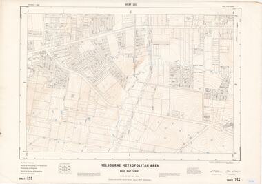
Map - Melbourne Metropolitan Area Base Map Series, Sheet 255 - Ringwood area, 1963
Map prepared by Dept of Lands and Survey and MMBW from State Aerial Survey December 1956 and Cadastral Survey information May 1963. This sheet comprises parts of the Municipalities of Ferntree Gully, Nunawading and Ringwood, and Parishes of Nunawading, Ringwood and Scoresby.Scale: 400 feet to 1 inch. Contours at 5 feet vertical interval. By Authority: A.C. Brooks, Commonwealth Printer, Melbourne.