-
 Bendigo Historical Society Inc.
Map - PARISH OF EGERTON, 19/03/1894
Map: Parish of Egerton, Settlement on Lands Act 1893, County of Bendigo. Parish plan ( number 245 in Map Cupboard 1)map, bendigo, settlement on lands act 1893, egerton, settlement on lands act 1893. -
 Eltham District Historical Society Inc
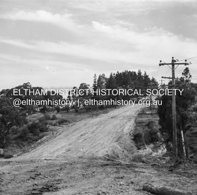
Negative - Photograph, J.A. McDonald, Para Road, Dec. 1960
Realignment Para Road December 1960 Taken from opposite Glenauburn RoadRecord of various Shire of Eltham infrastructure works undertaken during the period of 1952-1962 involving bridge and road reconstruction projects, sometimes with Eltham Shire Council Project Reference numbers quoted. It was during this period that a number of significant improvements were made to roads and new bridges constructed within the shire that remain in place as of present day (2022). In many situations, the photos provide a tangible visible record of infrastructure that existed throughout the early days of the Shire. The album was put together by or under the direction of the Shire Engineer, J.A. McDonald.infrastructure, shire of eltham, road construction, 1960-12, glenauburn road, para road -
 Montmorency/Eltham RSL Sub Branch
Map - Framed 1915 Anzac Cove Map, Gallipoli, 1915.ANZAC Cove Map, 1915
A framed map depicting trench lines and the battlefields of the Gallipoli Campaign, 1915, made by the Survey Department Egypt. Depth soundings of landing areas off Anzac Cove.Gallipoli - Anzac Cove World War One Map - 1915world war one, anzac, gallipoli, 1915, anzac cove, map, dardenelles, trench lines, depth soundings, landing areas -
 National Vietnam Veterans Museum (NVVM)
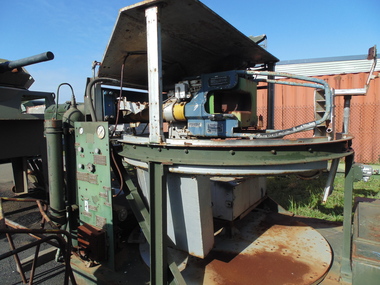
Education Kit, Centurion Tank Turret Training Module
Green coloured training module. Paint peeling off & rusty frame. Seat at the top with a long barrel coming out from the top & numerous brass knots & gauges.centurion tank, training module -
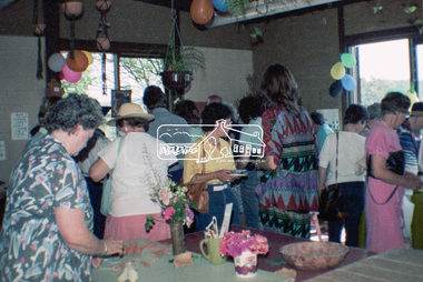
 Eltham District Historical Society Inc
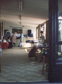
Negative - Photograph, Open Day, Eltham Living and Learning Centre, 7 Nov 1987
Open Day, Eltham Living and Learning Centre, part of the Eltham Community Festival activites, 7 Nov. 1987eltham, eltham festival, eltham living and learning centre, living and learning centre, open day -
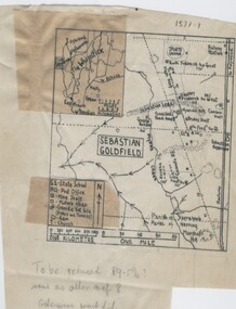 Bendigo Historical Society Inc.
Negative - TOM PATULLO COLLECTION: SEBASTIAN GOLDFIELD
Negative,/Hand drawn of the goldfield featuring gold mine sites,cyanide vats,heaps,railway station,sports ground. A small map of the Whipstick area, and legend. Tom Patullo was formerly of Clear-Ads Bendigo.cottage, miners, sebastian goldfield, sebastian goldfield -
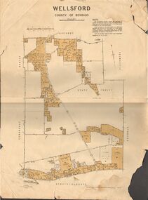 Bendigo Historical Society Inc.
Map - JACK FLYNN COLLECTION: WELLSFORD, 15/12/1941
Map: Parish of Wellsford, County of Bendigo. Parish plan. 2 copies of the same plan.map, bendigo, parish plan, wellsford -
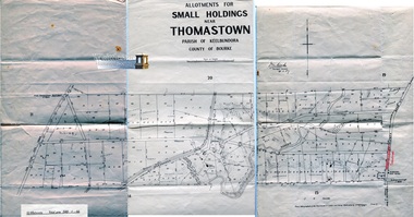 Whittlesea Historical Society Inc.
Map - Allotments for Small Holdings, near Thomastown, Parish of Keelbundora, County of Bourke, 24 Nov 1907
1 sheet, folded. Map 20 of 20 in green folder. Shows sizes of the blocks, between Yan Yean Pipe Track to the west and Plenty Road Bundoora to the east.J. V. Smith. Photo - lithographed at the Department of Lands and Survey Melbourne by T. F. McGauran. 4.12.07.map, yan yean pipe track, plenty road bundoora, maroondah aqueduct -
 Federation University Historical Collection
Map, Rokewood, 1937, 02/1937
printed colour map on paperrokewood, illabrook, woady yaloak river -
 Eltham District Historical Society Inc
Negative - Photograph, Open Day, Eltham Living and Learning Centre, 7 Nov 1987
Open Day, Eltham Living and Learning Centre, part of the Eltham Community Festival activites, 7 Nov. 1987eltham, eltham festival, eltham living and learning centre, living and learning centre, open day -
Bendigo Historical Society Inc.
Map - CAMPBELL COLLECTION: BENDIGO AND DISTRICT MAPS, 14-6-29
Map. Terricks, Parish of Terrick Terrick West, scale 20 chains to 1 inch, total area 6318 acres, prepared in W.P.B. from Assessment and Parish Plans by W.J.G. 14-6-29. (number 388 in map cupboard 1)W.J.Galbraithmap, bendigo, agricultural lands -
Glenelg Shire Council Cultural Collection
Negative - Glass Plate Negative - Picnic in a bush setting, c. 1890
Glass plate negative. Image shows a large group of people picnicking in bush setting. -
Bendigo Historical Society Inc.
Map - PARISH OF SHELBOURNE : COUNTY OF BENDIGO, 11-12-15
Map. Parish of Shelbourne, County of Bendigo, Marong, Lockwood, Ravenswood, Bradford, Laanecoorie, Woodstock. Photographed at the Department of Lands and Survey, Melbourne by W.J.Butson, 11-12-15. Price 1/-. By authority Albert J. Mullett, Government Printer, Melbourne. (number 32 in map cupboard 1)Albert J. Mullett, Government Printer, Melbourne.map, bendigo, shelbourne -
Bendigo Historical Society Inc.
Map - HUSTLER'S ROYAL RESERVE NO 2 CO. - LONGITUDINAL SECTION OF THE HUSTLER'S ROYAL RESERVE NO 2 CO
Longitudinal Section of the Hustler's Royal Reserve No 2 Co. on the Hustler's Line of Reef Bulletin No 33, Plate No VIII. Note - Plates 4, 8, 13, 20, 26 & 31 form a Longutudinal Section from Fortuna Hustler's to Hustler's Consols Mine. Mines mentioned are the Hustler's Royal Reserve No 2 Main Shaft, Hustler's Royal Reserve No 2 Park Shaft, Royal Hustler's, Imperial Hustler's, Great Extended Hustler's Freehold and the Great Extended. Section shows depth of levels, datum lines and height of sill above sea levelyield in ozs od gold. Geological Survey of Victoria emblem. H. Herman, Director, W. Dickson, Secretary for Mines and The Hon. J. Drysdale Brown MLC, Minister for Mines and signed by H S Whitelaw, Underground Survey Office Bendigo, September 1913. This item has not been scanned or photographed.mining, parish map, hustler's royal reserve no 2, longitudinal section of the hustler's royal reserve no 2 co, hustler's royal reserve no 2 (main shaft), hustler's royal reserve no 2 (park shaft), royal hustler's, imperial hustler's, great extended hustler's freehold, great extended, geological survey of victoria, underground survey office bendigo, h s whitelaw, h herman, w dickson, the hon j drysdale brown -
 Bendigo Historical Society Inc.
Map - JACK FLYNN COLLECTION: BEALIBA, 15/09/1931
Map: Parish of Bealiba, County of Gladstone. Parish plan.By Authority H.J. Green, Government Printer. Photo Lithographed at the Government of Lands and Survey Melbourne. 15.9.31map, gladstone, parish plan, bealiba, gladstone -
 Bendigo Historical Society Inc.
Negative - BENDIGO CHINESE TEA HOUSE
Construction of the Bendigo Chinese Tea House, Nolan Steet, Bendigo.buildings, commercial, tea house -
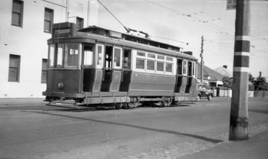
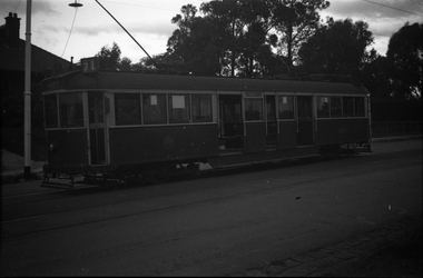 Melbourne Tram Museum
Negative - CW5 681 Riversdale Road, at Boundary Road, Wal Jack, c1940
Based on the pole number (178), photo most likely at Boundary (Warragul) Rd and Riversdale Road - see item 3644 for a map of pole numbers.Yields information about tram CW5 681 in Riversdale Road c1940Black and white negative, by Wal Jack, CW5 681, (City, route 71). Undated, c1940.trams, tramways, cw5 class, route 71, tram 681, riversdale road -
Bendigo Historical Society Inc.
Map - GOORNONG, Circa 1870's
Map: Suburban Lots in the Township of Goornongmap, bendigo, township, goornong, township of goornong -
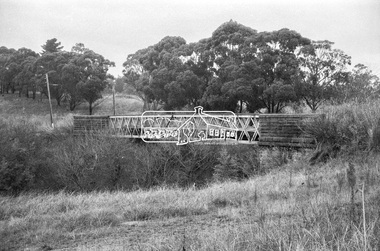 Eltham District Historical Society Inc
Negative - Photograph, Russell Yeoman, Old Lower Plenty Bridge, c.1970
Old bridge across the Plenty River at Lower Plenty now part of the Plenty River Trail. Part of a slide show presentation "Bridges & Waterways of the Shire" by Russell Yeoman to the 13 September 1989 Society meeting. The presentation included slides of historic photos from the Shire of Eltham Pioneers collections as well as several recent views.Roll of 35mm black and white negative film, 4 of 7 stripsIlford HP4bridge, lower plenty, main road, plenty river, plenty river trail -
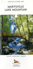 Marysville & District Historical Society
Map (Item) - Tourist map, Mystic Mountains Tourism, OFFICIAL VISITORS' MAP MARYSVILLE LAKE MOUNTAIN, Unknown
A visitors' map of Marysville and Lake Mountain produced by Mystic Mountains Tourism for Visit Victoria.A visitors' map of Marysville and Lake Mountain produced by Mystic Mountains Tourism for Visit Victoria.The Marysville and Lake Mountain Visitor Map and Touring Guide has been compiled and/ published by Mystic Mountains Tourism Inc. Copyright./ Production and artwork Graph Attack P/Lmarysville, lake mountain, victoria, australia, visitor's map, official visitors' map marysville lake mountain, buxton, narbethong, taggerty, visit victoria, mystic mountains tourism inc, graph attack p/l, mystic mountains, marysville triangle, marysville visitor information centre, marylands country house, black spur, steavenson falls, lady talbot drive, cambarville, cathedral ranges, wirreanda festival, lake mountain summit walk, summit walk loop, leadbeaters loop, day loop walk, buxton hotel, igloo roadhouse, karmann waters, silverstream b&b cottages, buxton trout and salmon farm, the niche wine bar, buxton post office & general store, choppers buxton roadhouse, woodlands rainforest bungalows, chestnut glade, black spur inn, wombat cottage, abbey lake luxury b&b spa cottages, mystic mountain ski hire & outdoors, pnl 4wdriving, blue views holiday units & ski hire, marapana agistment park & farm stay b&b, danico design, things of sand & stone, mantirri blueberry farm, allawah country cottages, amberview cottages, ashlar cottage b&b, black spur motel & caravan park, blackwood deluxe cottages, blackwood courtyard b&b, dalrymples guest cottages, delderfield, el kanah guest house, fruit salad farm, kerami guest house, keppels hotel, lake mountain-snow gum lodge, lomatia lodge, lyell guest cottages, magnolia house, keppel waters, lyrebird apartments, marysville caravan park, all view spa apartments, riverside cottages, maryton park b&b country cottages, melina cottage, mountain lodge, mystic mountains holiday cottages, nanda binya lodge, rendezvous luxury cottages, scenic b&b motel, the cumberland, south cathedral farm, tower motel, willowbank at taggerty, woodlands rainforest retreat, marysville & district country club inc, mystic mountains ski hire & outdoors, rubicon valley horse riding, marysville trout and salmon ponds, gallipoli park, keppels lookout, cambarville-yarra ranges national park, lake mountain-yarra ranges national park, lady talbot drive-yarra ranges national park, cathedral range state park, steavenson river, taggerty river, acheron river, lake mountain alpine resort, bruno's art and sculpture garden, manical mechanicals, uncle fred & aunty val's old style lolly shop, carmyle farm boutique, crossways historic country inn, fraga's, gilberts restaurant, heights licensed bistro, the old woolshed cafe, cathedral view natural therapies, crystal journey -
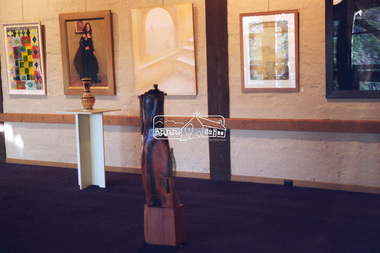 Eltham District Historical Society Inc
Negative - Photograph, Art show, Eltham Community Centre, c.1994
Art show held in the Eltham Community CentreRoll of 35mm colour negative film, 1 stripKodak Gold 100-4art exhibition, eltham community centre -
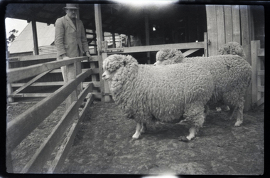 National Wool Museum
Negative - Sheep, J W Allen, 1928-1929
This negative was found loose in the first of three albums compiled and owned by J W Allen, Secretary of New South Wales Grazier's, and is associated with the New South Wales Graziers Association world tour of sheep 1928-1929. The album contains photographs of travel, sheep, farms, stations, people and landscapes from around the world. Locations include Naples, Port Said, Suez, Birregurra (Vic), Alexandra (Vic), Ballangeich (Vic), Keith (SA), Mt Gambier (SA), Buckland Park (SA), Tasmania, Winton (QLD), Sydney Harbour, Canberra (ACT), Toowoomba (QLD), Rockhampton (QLD), Tocal (NSW), Deepwater (NSW), Glen Innes (NSW), Longreach (QLD), Moree (NSW), Barraba (NSW) and Mudgee (NSW). Properties depicted include Mooleric, Turkeith, Woolongoon, Minadale, Crower Station, Merrindie, Koomooloo Station, Cappeedee, Koonoona, Rathmore, Ellenthorpe, Camden Park Station, Glenlegh, Strathmore Station, Ilparran Station, Binneguy, Midkin, Terlings, Ashley, Bereen, Plumthorpe, Mayvale and Havilah. The album was found in a clean out at the Great Southern Agricultural Research Institute and donated to the National Wool Museum, along with other related material such as photographs, glass lantern slides and ephemera.Black and white negative showing three sheep in stockyards with a man standing to the left. agriculture, sheep, farming, stations, research, breeding, photography, travel -
Bendigo Historical Society Inc.
Map - TARNAGULLA SHEET 2, No date Visible
Map: Tarnagulla Sheet 2, Parish planmap, parish plan, tarnagulla -
Bendigo Historical Society Inc.
Map - RAYWOOD GOLD FIELD MAP, 1902
Map. Raywood Gold Field Map. Linen backed map of Raywood and Neilborough Township and surrounds showing the location of varying underground workings. Surveyed by H S Whitelaw 1/6/02. It shows underground workings from The Perseverance Party and moreshed and Party and underground workings on the Old Pioneer Reef. Mentions the Parish of Yallook, Parish of Neilborough, Yarraberb, Mushroom Flat, Murray Valley Plain, Eaglehawk and Kerang Railway, Green Hill, Doughboy, Redmond's Gully, Pickpocket Lead, Raywood Lead, Inglewood Lead, Shaw's Road, Nuggety Shaft, Barkly Shaft, Maori Bendmap, gold field map, raywood gold field map, neilborough, h s whitelaw, geological survey of victoria bulletin no 12 plate 11 -
Bendigo Historical Society Inc.
Negative - LA TROBE UNIVERSITY BENDIGO COLLECTION: BENDIGO TEACHERS' COLLEGE PHOTOGRAPHIC NEGATIVES
A collection of negatives of photographs collected by Ms. J.C. Burnett in preparation for her book titled 'History of Bendigo Teachers' College, 1926-1973.' This book was published by Cambridge Press in 1973. Note: (These negatives have not been scanned).bendigo, education, negatives, la trobe university bendigo collection, collection, bendigo teachers' college, education, bendigo, tertiary education, teacher training, ms. j.c. burnett, history of bendigo teachers' college 1926-1973, negative, negatives, photo, photograph, photographs, photography, proof, history -
 Federation University Historical Collection
Map - Report, H.S. Whitelaw, Report on the Little Bendigo or Nerrina Gold-Field, Ballarat, 1901
Blue soft covered book. Includes Contour plan of the Little Bendigo Goldfieldlittle bendigo, nerrena, nerrina, h.s. whitelaw -
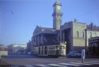
 Ballarat Tramway Museum
Negative, Wal Jack, early 1950's
Negative and Digital images of the Wal Jack Ballarat Negative file of Geelong 21 at the West terminus with the Telegraph Hotel in the background. The tram has the destination of East in the rear canopy and the West in the side destination. The adjacent pole has the End of section sign and the painted markings.trams, tramways, geelong, west, signs, tram 21 -
 Melbourne Tram Museum
Negative, Travis Jeffrey, 1/06/1962 12:00:00 AM
Colour negative of tram 547 in Bridge Road Richmond. Tram 547 has destination Camberwell Depot - Burke Rd and Route No 76. Set of two negatives.Paper folder that contained the negative had "NR75B" and date written as 10 Jun 62 in red ink.trams, tramways, w2 class, route 76, bridge rd, richmond, camberwell depot, tram 547 -
Whitehorse Historical Society Inc.
Map, Heritage overlay map, 1/02/1999 12:00:00 AM
City of Whitehorse heritage review : Heritage overlay map.City of Whitehorse heritage review : Heritage overlay map.City of Whitehorse heritage review : Heritage overlay map.city of whitehorse, historic buildings, blackburn, blackburn south, blackburn north, mitcham, nunawading, forest hill, vermont, vermont south, burwood east -
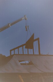
 Eltham District Historical Society Inc
Negative - Photograph, Construction work, Main Street Bridge, Greensborough, c.Dec. 1983
The original bridge over the Plenty River was replaced by a single lane bridge each way fed by two lanes each way on either side. As traffic grew a second bridge was added to complete the divided road across the riverFilm - Kodak CM 400 5079 7 strips, 26 framesinfrastructure, roads, bridge construction, greensborough, main street bridge, road construction