-
 Glenelg Shire Council Cultural Collection
Map - Map - Glenelg River, 1975
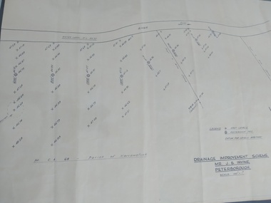
Laminated map, Glenelg River - Casterton, proposed flood level and lines to be designated. Photograph of map taken in 1975. Produced by Rural Water Commission to Shire Engineer, Casterton, attached to reverse of map.flood, flood levels, casterton -
 Marysville & District Historical Society
Map (Item) - Information brochure, Project Art & Photo, Marysville in the Mystic Mountains, Unknown
An information brochure on Marysville, the surrounding district and the natural attractions in the region published by Mystic Mountains Tourism.An information brochure on Marysville, the surrounding district and the natural attractions in the region published by Mystic Mountains Tourism.marysville, victoria, australia, information brochure, mystic mountains, mystic mountains tourism, cathedral range, lady talbot drive, cameron cascades, phantom falls, keppel falls, beech forest cascades, the beeches rainforest walk, the big tree, cumberland memorial scenic reserve, cambarville, cumberland falls, cora lynn falls, the big culvert, steavenson falls, lake mountain, marysville visitor information centre -
 Kew Historical Society Inc
Plan - Subdivision Plan, Old Kew Golf Links Estate - Third Section, 1920-1929
Pru Sanderson, in her groundbreaking ‘City of Kew Urban Conservation Study : Volume 2 - Development History’ (1988), summarised the periods of urban development and subdivisions of land in Kew. The periods that she identified included 1845-1880, 1880-1893, 1893-1921, 1921-1933, 1933-1943, and Post-War Development. These periods were selected as they represented periods of rapid growth or decline in urban development. An obvious starting point for Sanderson’s groupings involved population growth and the associated economic cycles. These cycles also highlighted urban expansion onto land that was predominantly rural, although in other cases it represented the decline and breakup of large estates. A number of the plans in the Kew Historical Society’s collection can also be found in other collections, such as those of the State Library of Victoria and the Boroondara Library Service. A number are however unique to the collection.The Kew Historical Society collection includes almost 100 subdivision plans pertaining to suburbs of the City of Melbourne. Most of these are of Kew, Kew East or Studley Park, although a smaller number are plans of Camberwell, Deepdene, Balwyn and Hawthorn. It is believed that the majority of the plans were gifted to the Society by persons connected with the real estate firm - J. R. Mathers and McMillan, 136 Cotham Road, Kew. The Plans in the collection are rarely in pristine form, being working plans on which the agent would write notes and record lots sold and the prices of these. The subdivision plans are historically significant examples of the growth of urban Melbourne from the beginning of the 20th Century up until the 1980s. A number of the plans are double-sided and often include a photograph on the reverse. A number of the latter are by noted photographers such as J.E. Barnes.When the old Kew Golf Links was subdivided in the mid 1920s, the developers were able to break the sale into sections. The third section included eighty lots. The lots faced Kilby Road, Kodak Avenue, Belford Road, Baker Avenue, Mathers Avenue, and White Avenue. [Kodak Avenue was renamed Page Avenue at a later date].The ‘Kew Conservation Study (1988) notes that ‘On the subdivision plan, Kodak’s involvement is commemorated by the naming of the streets after Company directors, and their decision to not proceed with the construction of the factory is explained as a response to the increase in the value of the land. This explanation may have been Estate Agent’s hyperbole, as the Kodak Company records suggest that the land, with its wide creek gully, was unsuitable and too small for its purposes.subdivision plans - kew, old kew golf links estate - third section -
Moorabbin Air Museum
Map (Item) - Middle East Egypt WW1 AFC Map
-
 Peterborough History Group
Plan, Drainage Improvement Scheme. Mr J.S. Irvine. Peterborough
Assumed to be a plan of the drainage at The Lodge farmIndication of land levels c1970Professionally drawn plan of drainage scheme for J. S. Irvine.the lodge farm, drainage plan, j. s. irvine -
Port Melbourne Historical & Preservation Society
Map - MMBW, 1894
Melbourne and Metropolitan Board of Works 1894 Plans No. 338, 339, 355, 356 Segments shown: As plan No's: Bridge to Graham, Evans to Nott. (Large scale - 40'=1")311/H, 17engineering - board of works, hotels, built environment, education - primary schools, graham street state school, port melbourne primary school -
Bendigo Historical Society Inc.
Map - PARISH OF RAVENSWOOD, Circa 1908
Map: Parish of Ravenswood, Counties of Bendigo and Talbot. Parish planmap, bendigo, parish plan, ravenswood, county of talbot -
 Ballarat Tramway Museum
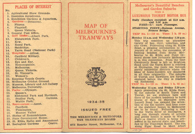
Map, Melbourne and Metropolitan Tramways Board (MMTB), "MMTB Map of Melbourne Tramways 1934-5", 1934
Demonstrates methods of giving information to visitors to Melbourne and yields information about tram services at the time in Melbourne.Very small pocket sized timetable and map book, consisting of 2 octavo cards stapled and folded into 12 pages consisting of three pages of bus and tram round trips, 3 center pages for map of electric and cable trams, route numbers and interest points. Map printed in 4 colours. 4 pages index to routes and first and last trams to City and from City. Also gives points where suburban routes are intersected by City routes. One page devoted to places of interest. All printing in black with red headings and highlights.trams, tramways, mmtb map, mmtb, timetables, tourist trips, map -
 B-24 Liberator Memorial Restoration Australia Inc
Map - US World War II multi-coloured map - Philippine Series, No. C-43 Mindanao Series, No. C-44 North Borneo, 1944
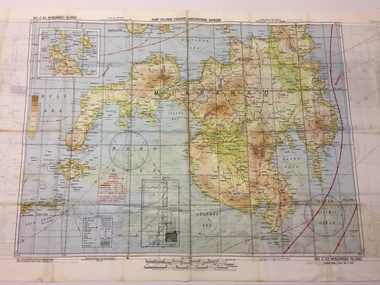
Silk and rayon maps were produced by the United States (c. 7.5 million in total), Great Britain (some 1.75 million in total) and Australia during World War II. They were issued to Allied military personnel as part of 'escape and evasion' kits.This map, printed on acetate rayon, is an original US 'escape and evasion' kit map from World War II.A multi-coloured, contoured, double-sided map printed on acetate rayon AAF Cloth Chart - Philippine Series Side 1 - No. C-43 Mindanao Series Side 2 - No. C.44 North Borneounited states of america, silk and rayon maps, world war ii -
 Kew Historical Society Inc
Plan - Subdivision Plan, Doona Estate, Toorak, 1929
The Kew Historical Society collection includes almost 100 subdivision plans pertaining to suburbs of the City of Melbourne. Most of these are of Kew, Kew East or Studley Park, although a smaller number are plans of Camberwell, Deepdene, Balwyn and Hawthorn. It is believed that the majority of the plans were gifted to the Society by persons connected with the real estate firm - J. R. Mathers and McMillan, 136 Cotham Road, Kew. The Plans in the collection are rarely in pristine form, being working plans on which the agent would write notes and record lots sold and the prices of these. The subdivision plans are historically significant examples of the growth of urban Melbourne from the beginning of the 20th Century up until the 1980s. A number of the plans are double-sided and often include a photograph on the reverse. A number of the latter are by noted photographers such as J.E. Barnes.The Doona Estate subdivision of 1929 created 11 new allotments bordered by Glenferrie Road, Stonnington Place, Cross and Church Streets. On the right of the plan, the location of ‘State Govt. House’ is noted. Stonnington was to be maintained as Victoria’s Government House until 1931, two years after the Doona Estate subdivision was released.subdivision plans - toorak, doona estate -
 Melbourne Tram Museum
Map, Sands McDougall, "New plan Melbourne and Suburbs Sands & McDougall's Melbourne and Suburban Directory", 1910
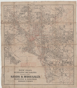
Shows railways, horse, cable and electric tram lines c1910. One of a number of maps produced by Sands McDougall of Collins St. Includes the MTOCo zoo horse tram lines, the NMETL and VR lines, but not the PMTT. Includes the Caulfield Elsternwick horse tram lines. Possibly included in Sands and McDougall directories based on the title. See items 2885, 6573 and 6916 for other editions. Yields information about Melbourne c1910 and its public transport lines. Cloth-backed and folded sheet of paper 5 sections wide x 4 sections or folds deep. Produced by Sands and McDougall Pty Ltd of Collins St Melbourne. maps, melbourne, cable trams, tramways, railways, horse trams, nmetl, vr trams, sands mcdougall, zoo horse tramway -
University of Melbourne, Burnley Campus Archives
Plan, Glenferrie PR. S. No. 1508: Detail Survey, 1982
Original and 2 copies of Public Works Department, Victoria plans of Glenferrie Primary School for the Department of Education SU 2241.2. Shows site plan and Pit Schedule.glenferre primary school, survey -
Clunes Museum
Map - MAPS, 28/02/1971
ORIGINAL MAP - CLUNES CARAVAN PARKlocal history, document, maps, clunes township -
 Northern District School of Nursing. Managed by Bendigo Historical Society Inc.
Education kit - Present Day Nurse Miniature Doll - Nursing through the Ages
In 1951 the Modern Day/Present Day Nurse uniform was selected complete with apron and red cape. This uniform continued through to 1972. 30cm Miniature doll blue dress white apron and red capeName Tagnursing history, nursing uniforms, northern district school of nursing, miniature dolls -
Federation University Historical Collection
Plan, Proposed New Buildings for the Ballarat School of Mines, 1966, 05/1966
The Diploma Subjects Building was designed to be erected on the M.B. John Factory site (Lydiard Street towards Armstrong St), to provide facilities for the tertiary sector of the Ballarat School of Mines. This proposal was aborted when the Mount Helen Campus site was acquired and a new campus started there in 1967. Many of the laboratories shown in these plans were incorporated, in modified form, in single-storey buildings on Mt Helen campus.Plans for proposed building for Diploma students at the Ballarat School of Mines. The building was not built.ballarat school of mines, proposed buildings, l.h. vernon and associates -
Port Melbourne Historical & Preservation Society
Plan - Various ships, Melbourne Harbor Trust, 1980s
Various shipping plans of passenger ships from Melbourne Harbor Trust 1980s.piers and wharves - station pier, melbourne harbor trust - port of melbourne authority -
Stawell Historical Society Inc
Map, Western Mining Corp / Stawell Joint Venture, Three dimensional View of Wonga Open Cut & Decline, April 1992
Cutaway perspective showing DeclinesView Looking North West with Cut Away Showing Underground Development Floorplanmining, gold -
Bendigo Historical Society Inc.
Map - CAMPBELL COLLECTION: BENDIGO AND DISTRICT MAPS
Map. Eaglehawk, Parishes of Huntly and Nerring. Scale 20 chains to 1 inch. Total area 6211 acres. Eaglehawk Kerang Railway, to Epsom 2 miles. Manure Depot. (number 390 in map cupboard 1)map, bendigo, allotments -
 Federation University Historical Collection
Plan, School of Mines, Ballarat: Front elevation plan for new building, 1899
Mounted photocopy of plans for 1899ballarat school of mines, plan, front elevation, new classrooms, administration building, a building, architectural drawing -
 Queenscliffe Maritime Museum
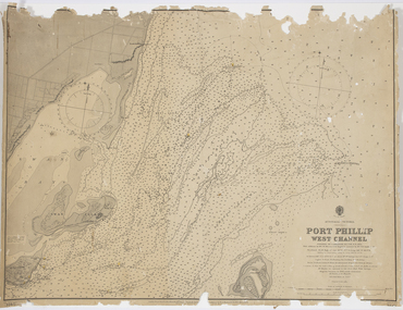
Map - Survey Charts, Port Phillip West Channel
These charts show changes to the depth levels surrounding Queenscliff. Earlier chart does not show the cut which can be seen in the later chart. The creation of the cut and subsequebt dredging of it has changed the shoreline due to shifting sand.Two charts of the Port Phillip West Channel, reference number 309. One was engraved in 1903, the other a new 1935 edition last revised in 1961.Port Phillip West Channelport phillip, queencliff channel, charts, soundings -
Glen Eira Historical Society
Plan - Bokhara Road, 28, Caulfield South
A hand drawn plan (75mm x 147mm) of the house at Bokhara Road, 28, Caulfield, undated and unattributed. The plan includes notes about the dimensions and fittings of the house.bokhara road, caulfield south -
Whitehorse Historical Society Inc.
Map, Burwood Highway, c1970
Enlarged aerial photo of area South of Burwood Highway to Dandenong Creek, Vermont South.Enlarged aerial photo of area South of Burwood Highway to Dandenong Creek, Vermont South.Enlarged aerial photo of area South of Burwood Highway to Dandenong Creek, Vermont South.dandenong creek, morack road, vermont south, burwood highway, vermont south, aerial photographs -
 Kew Historical Society Inc
Plan, Melbourne & Metropolitan Board of Works : Borough of Kew : Detail Plan No.1575, 1905
The Melbourne and Metropolitan Board of Works (MMBW) plans were produced from the 1890s to the 1950s. They were crucial to the design and development of Melbourne's sewerage and drainage system. The plans, at a scale of 40 feet to 1 inch (1:480), provide a detailed historical record of Melbourne streetscapes and environmental features. Each plan covers one or two street blocks (roughly six streets), showing details of buildings, including garden layouts and ownership boundaries, and features such as laneways, drains, bridges, parks, municipal boundaries and other prominent landmarks as they existed at the time each plan was produced. (Source: State Library of Victoria)This plan forms part of a large group of MMBW plans and maps that was donated to the Society by the Mr Poulter, City Engineer of the City of Kew in 1989. Within this collection, thirty-five hand-coloured plans, backed with linen, are of statewide significance as they include annotations that provide details of construction materials used in buildings in the first decade of the 20th century as well as additional information about land ownership and usage. The copies in the Public Record Office Victoria and the State Library of Victoria are monochrome versions which do not denote building materials so that the maps in this collection are invaluable and unique tools for researchers and heritage consultants. A number of the plans are not held in the collection of the State Library of Victoria so they have the additional attribute of rarity.Original survey plan, issued by the MMBW to a contractor with responsibility for constructing sewers in the area identified on the plan within the Borough of Kew. The plan was at some stage hand-coloured, possibly by the contractor, but more likely by officers working in the Engineering Department of the Borough and later Town, then City of Kew. The hand-coloured sections of buildings on the plan were used to denote masonry or brick constructions (pink), weatherboard constructions (yellow), and public buildings (grey). Plan No.1575 shows that in the area bounded by Wellington Street, Edgevale Road, Glenferrie Road, and Cotham Road, there had already been significant subdivision of land and houses constructed. As one of the highest points in Kew, as expected, there were already some significant mansions built on large allotments of land. Many of these mansions are identified by name on the plan such as ‘Kelso’, ‘Abbotsford’, ‘Clarendon’ and ‘Ashlyn’ in Cotham Road. Other houses of equal size are unnamed on the plan.melbourne and metropolitan board of works, detail plans, maps - borough of kew, mmbw 1575, cartography -
Bendigo Historical Society Inc.
Map - CAMPBELL COLLECTION: BENDIGO AND DISTRICT MAPS
Map. Mandurang, Parish of Mandurang, Scale 20 chains to 1 inch. Total area 5993 acres, Northern Railway to left of map, Water Reserve (Spring Gully). (number 363 in map cupboard 1)map, bendigo, allotments -
Moorabbin Air Museum
Plan (item) - Bristol Aeroplane 170 schematic drawings, Gussett Centre Plane
Bristol Aeroplane Company Ltd -
Whitehorse Historical Society Inc.
Map, Parkmore Estate, c1958 - 1959
Plan of 'Parkmore' subdivision by Southern Construction Company, 444 lots, c 1958-59.land subdivision, forest hill, parkmore road, forest hill, ranfurlie road, forest hill, ranfurlie court, forest hill, everglade avenue, forest hill, hampshire road, forest hill, quentin street, forest hill, cedar court, forest hill, martin court, forest hill, wandin court, forest hill, inglewood avenue, forest hill, deauville street, forest hill, oberon street, forest hill, vanbrook street, forest hill, husband road, forest hill, springvale road, forest hill, southern construction company -
 Kew Historical Society Inc
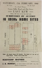
Plan - Subdivision Plan, Subdivision by Auction: 16 Ideal Home Sites, East Kew, 1940
An advertisement for the sale of a subdivision by Auction: of 16 Ideal Home Sites, East Kew, 1940. This significant sale of land between the Kew Golf Course and Willsmere Park led to the streets having a high degree of architectural uniformity.The subdivision in the second year of the war indicates that land sales for homes and speculation continued from the 1930s into the period of the Second World War. There is no indication on the plan that a war is occurring.Single page subdivision plan advertising the sale by Auction of 16 Ideal Home Sites, in East Kew, on 17 February 1940. Streets named in the plan include: Kilby Road, Belford Road, Elm Grove, Willow Grove. Willsmere Park is indicated but not named. The auction was conducted by Beauchamp Brothers. A number of lots are coloured pink on the plan indicating those lots for sale and/or those already sold.subdivision plans - kew east (vic) -
 Bendigo Historical Society Inc.
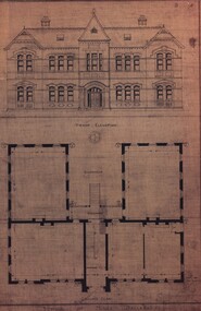
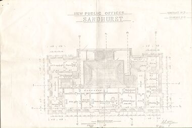
Plan - NEW PUBLIC OFFICES SANDHURST
Photocopy of Plan for New Public Offices Sandhurst 1883-1887 - Drawing No3/Contract No2bendigo, planning, sandhurst -
Bendigo Historical Society Inc.
Map - REDESDALE : COUNTY OF BENDIGO, 25 -10-77
Map. Redesdale, County of Bendigo, County of Dalhousie, County Of Talbot, Lyell, Kimbolton, Langwornor, Spring Plains, Glenhope, Emberton, Metcalfe, Hawkestone, River Coliban, Campaspe River, Back Creek. Photo-Lithographed at the Department of Lands and Survey, Melbourne by J. Noune, 25-10-77. Compared with original plans 12-11-78 M. Kemp. J.C.Kelsh, Draughtsman April 1876. Examined by E. Downward, 5-6-77. (number 121 in map cupboard 1)J. Nounemap, bendigo, redesdale -
Glenelg Shire Council Cultural Collection
Map - Map - RACV Road Map, 1970s
RACV road map, Warrnambool District, Port Fairy to Lorne. Large coloured map of Warrnambool District. Small maps of Apollo Bay, Colac, Camperdown, Tower Hill and Warrnambool. When folded, black and white photo on cover of 12 Apostlesracv, road touring, road map, victoria