-
 Port Melbourne Historical & Preservation Society
Plan - Alterations, Port Melbourne Town Hall, Bay Street, Port Melbourne City Council, 1930s
Plan on tracing paper of proposed alterations to Town Hall 1930s.port melbourne town hall, built environment - civic, engineering department - city of port melbourne, bay street, city engineers, fred cook -
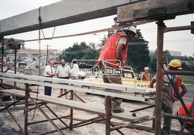 Eltham District Historical Society Inc
Negative - Photograph, Construction work, Main Street Bridge, Greensborough, c.Aug. 1978
The original bridge over the Plenty River was replaced by a single lane bridge each way fed by two lanes each way on either side. As traffic grew a second bridge was added to complete the divided road across the riverFilm - Kodak CM 400 5079 7 strips, 26 framesinfrastructure, roads, bridge construction, greensborough, main street bridge, road construction -
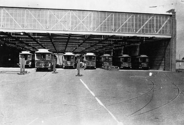 Melbourne Tram Museum
Negative, Wal Jack collection, early 1936
Negative of a photograph of the Brunswick Electric tram depot with many cable tram trailers in the depot, with body jacks in position, to load cars that had been sold onto a person's truck. Also one set of possibly cable bogies in front of car 191. Brunswick depot opened for electric cars on 26/4/1936. Trailers - Cable tram 457, 495, 486, 481, 191, 45 182 from the left. The Brunswick cable line was closed 11/1/1936 and Brunswick depot was opened 26/4/1936.Written on rear of album print - "Cable tram 457, 495, 486, 481, 191, 45 182 in the new tram sheds at Brunswick, now used for electric trams."trams, tramways, cable trams, brunswick depot, sale of trams, tram 457, tram 495, tram 486, tram 191, tram 45, tram 182 -
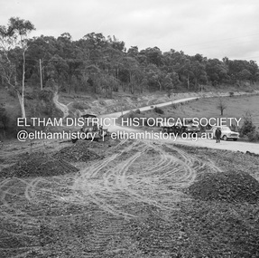 Eltham District Historical Society Inc
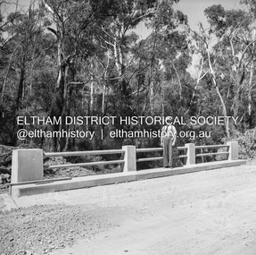
Negative - Photograph, J.A. McDonald, Eltham-Diamond Creek Road, 18 Sep 1959
Bridge construction Eltham-Diamond Creek road over the Diamond Creek (Wattletree Road), Eltham, September 1959 After some delay in receiving funds, work started on the bridge approaches in early September 1959. Traffic was still using the old bridge upstream. On Sunday, 20 September 1959, heavy flooding occurred in the stream and at 3:53 pm the old bridge was washed out. This photo was taken the Friday beforeRecord of various Shire of Eltham infrastructure works undertaken during the period of 1952-1962 involving bridge and road reconstruction projects, sometimes with Eltham Shire Council Project Reference numbers quoted. It was during this period that a number of significant improvements were made to roads and new bridges constructed within the shire that remain in place as of present day (2022). In many situations, the photos provide a tangible visible record of infrastructure that existed throughout the early days of the Shire. The album was put together by or under the direction of the Shire Engineer, J.A. McDonald.infrastructure, shire of eltham, bridge construction, 1959-09-18, bridge, diamond creek (creek), eltham, eltham north, glen park bridge, wattletree road bridge -
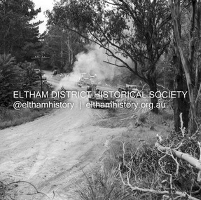 Eltham District Historical Society Inc
Negative - Photograph, J.A. McDonald, Heidelberg-Kinglake Road, Oct. 1959
Job 56M431 Contractors Wolf and Wood Yow Yow Creek Bridge Bypass road and bridge finished October 1959Record of various Shire of Eltham infrastructure works undertaken during the period of 1952-1962 involving bridge and road reconstruction projects, sometimes with Eltham Shire Council Project Reference numbers quoted. It was during this period that a number of significant improvements were made to roads and new bridges constructed within the shire that remain in place as of present day (2022). In many situations, the photos provide a tangible visible record of infrastructure that existed throughout the early days of the Shire. The album was put together by or under the direction of the Shire Engineer, J.A. McDonald.infrastructure, shire of eltham, bridge construction, heidelberg-kinglake road, 1959-10, road construction, scan - 120 format 6x6 negative, yow yow creek -
 Ballarat Tramway Museum
Negative, Wal Jack, late 1940's or early 1950's
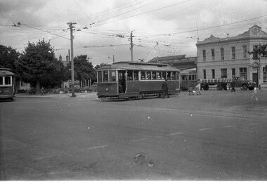
Yields information about the tram services and the way they could co-ordinate at Hospital Corner and other traffic.Negative and Digital image of the Wal Jack Ballarat Negative file of three trams at Hospital corner. No. 20 has turned from Drummond North in Sturt - City No. 21 from Sturt in Drummond North - Gardens via Drummond North No. 15 in Sturt St for Gardens via Sturt St west. In the background is the Southern Cross Hotel. There is a lady with a pram and beer delivery truck.trams, tramways, hospital corner, sturt st, drummond st, tram 20 tram 21 tram 15 -
 Ballarat Tramway Museum
Negative, Wal Jack, late 1940's or early 1950's
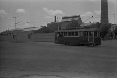
Yields information about the tram services and the Ballarat A Power Station.Negative and Digital image of the Wal Jack Ballarat Negative file of No. 11 southbound in Ripon St passing Ballarat A power station.trams, tramways, ripon st, ballarat a power station, tram 27 -
 Federation University Historical Collection
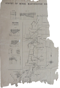
Plan, Survey of Mines, Maryborough District, not dated
Maryborough is a Central Victorian town. Printed section of the Maryborough Districtmaryborough, carisbrook, majorca, horizontal sections, vertical sections, chalk's no 4, east kong meng, craigie -
University of Melbourne, Burnley Campus Archives
Plan (item)
-
 Federation University Historical Collection
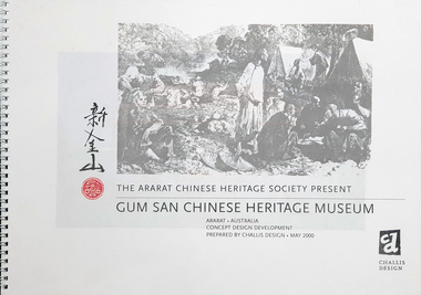
Plan, The Ararat Chinese Heritage Society Present Gum San Chinese Heritage Museum Concept Design and Development
Dick de Fegley who was on the University of Ballarat Council was highly involved with the development of Gum San Museum. University of Ballarat is a predecessor of Federation University.A3 document containing plans and information pertaining to the development of Gum San Chinese Heritage Museumdick de fegely, gum san chinese heritage museum, challis design, ararat chinese heritage society -
 Kew Historical Society Inc
Plan - Subdivision Plan, Shop Sites, East Kew, c.1927
Subdivision plans are historically important documents used as evidence of the growth of suburbs in Australia. They frequently provide information about when the land was sold on which a built structure was subsequently constructed as well as evidence relating to surveyors and real estate and financial agents. The numerous subdivision plans in the Kew Historical Society's collection represent working documents, ranging from the initial sketches made in planning a subdivision to printed plans on which auctioneers or agents listed the prices for which individual lots were sold. In a number of cases, the reverse of a subdivision plan in the collection includes a photograph of a house that was also for sale by the agent. These photographs provide significant heritage information relating house design and decoration, fencing and household gardens.This is one of a small number of subdivision plans for commercial property in the collection. The subdivision proposed to create six shop sites in High Street between the Harp of Erin and Station Street. The plan shows this stretch of High Street, East Kew already lined with shops that include the hotel on the corner, the new State Savings Bank, a dentist’s surgery and Lambert’s Store. The High Street Tram was to reach Burke Road in 1925, so the proposed subdivision must postdate that event, and the opening of the Bank in 1926.subdivision plans - east kew, high street - east kew -
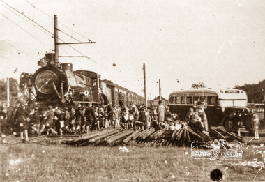 Eltham District Historical Society Inc
Negative - Photograph, Victorian Centenary Jubilee Steam Train 430, meeting with Eltham Bus Service, 1951
Roll of 35mm colour negative film, 4 stripsKodak Safety 5035eltham bus service, steam train, victorian centenary jubilee steam train 430 -
 Kew Historical Society Inc
Plan, Studley Park Estate, 1910
Prue Sanderson, in her groundbreaking ‘City of Kew Urban Conservation Study : Volume 2 - Development History’ (1988), summarised the periods of urban development and subdivisions of land in Kew. The periods that she identified included 1845-1880, 1880-1893, 1893-1921, 1921-1933, 1933-1943, and Post-War Development. These periods were selected as they represented periods of rapid growth or decline in urban development. An obvious starting point for Sanderson’s groupings involved population growth and the associated economic cycles. These cycles also highlighted urban expansion onto land that was predominantly rural, although in other cases it represented the decline and breakup of large estates. A number of the plans in the Kew Historical Society’s collection can also be found in other collections, such as those of the State Library of Victoria and the Boroondara Library Service. A number are however unique to the collection.The Kew Historical Society collection includes almost 100 subdivision plans pertaining to suburbs of the City of Melbourne. Most of these are of Kew, Kew East or Studley Park, although a smaller number are plans of Camberwell, Deepdene, Balwyn and Hawthorn. It is believed that the majority of the plans were gifted to the Society by persons connected with the real estate firm - J. R. Mathers and McMillan, 136 Cotham Road, Kew. The Plans in the collection are rarely in pristine form, being working plans on which the agent would write notes and record lots sold and the prices of these. The subdivision plans are historically significant examples of the growth of urban Melbourne from the beginning of the 20th Century up until the 1980s. A number of the plans are double-sided and often include a photograph on the reverse. A number of the latter are by noted photographers such as J.E. Barnes.Coloured lithograph of a subdivision plan of the Studley Park Estate, bordered by Yarra, Willsmere Road and the Outer Circle Railway line. The estate was listed in 1910 and was the subject of a planning dispute between the developer and the Town of Kew in relation to flood levels and the suitability of the land for housing. In many cases the names of streets were subsequently changed. The layout was also affected by the creation of the Eastern Freeway. A newspaper report of the day described the subdivision as a: "GOLDEN OPPORTUNITY. We are pleased to submit for PRIVATE SALE that magnificent ESTATE, situated only 4 1/2 miles from the Melbourne General Post Office, STUDLEY PARK ESTATE. KF/NV. Doubtless the CHEAPEST LAND EVER OFFERED having extensive frontages to the prettiest spot on the River Yarra and the National Park, commanding lovely river and landscape views, and acknowledged to be the finest land available so close to the city. The PRICES ARE EXTREMELY MODERATE; The TERMS ARE SIMPLY MARVELLOUS. NO DEPOSIT. NO DEPOSIT. NO DEPOSIT. Allotments and prices to suit everyone."subdivision plans - kew, studley park estate -
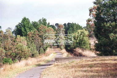 Eltham District Historical Society Inc
Negative - Photograph, Looking northwest along the Maroondah Aqueduct Trail towards The Esplanade near Main Road, Research, 1991
Roll of 35mm colour negative film, 9 strips Colour print 10 x 15 cmFuji HG 200 CA-1maroondah aqueduct, maroondah aqueduct trail, research (vic.), the esplanade -
Bendigo Historical Society Inc.
Plan - MARKS COLLECTION: HARRISON'S QUARTZ PULVERISER PLAN
Sepia coloured heavy paper, plans drawn in black pen. Written on top of plan : Youngman Harrison's Patent, 22 march 1875' Plans contain drawings labelled as copper pages, roller, grating, drag. Plan has been tightly rolled. On outer edge, written in black pen Harrison Quartz Tailings Pulveriser (last word unclear)mining, equipment, quartz tailing pulverisor -
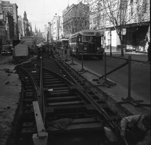 Ballarat Tramway Museum
Negative, Geoff Grant, 26/05/1954 12:00:00 AM
Negative No. 278 and colour print made by colour laser printer (stored in folder ) of the construction of the crossover in Bourke St near Queen St., 26/5/1954. Has two buses in photo travelling west. The first bus number 592 with registration AT092 currently owned (1/2001) by BTM Vice President John Phillips. Shows barriers and track construction arrangements. Photo by Geoff Grant. Includes what would appear to be an immigrant worker. Hi res scan of negative and image updated 19/5/2020.trams, tramways, melbourne, bourke st, construction, queen st, trackwork, tram bus 592 -
Port Melbourne Historical & Preservation Society
Plan - Seamen's Mission, Harry Norris, Blueprints, 1980s
Plans copied by Brian Couldrey when he was running the Mission Arts Centre in the building (1987 -1991).Photocopies (12) of blueprints of Plans for 1937 Seamen's Mission, by Harry Norris, in A4 sections - Ground floor - sheets f - l and First floor sheets a - e.architecture, missions to seamen, harry a norris -
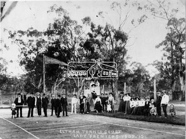 Eltham District Historical Society Inc
Negative - Photograph, Eltham Tennis Court. Lady Premiers 1909-1910, 1910
A large group of men and women pose for a photograph on Eltham tennis court. Although the photo is marked ”Lady Premiers”, this is not a typical formal sports group pose, with only two women identified as holding racquets. 33 individuals, including men and children and one dog pose for the camera, the majority of whom are not dressed to play tennis. The court shows clear markings for tennis and a flag is flying in the background. The photograph is taken from inside the wire enclosure. There are mature gum trees in the background. The tennis court was situated in Eltham South at Bremner’s Flats (near present day Wingrove Park). Cross Ref SEPP_0720 which is at an earlier level of development. The Eltham Lawn Tennis Club was formed on a Saturday evening, the 29th of October, 1898 at a meeting held at the Eltham State school. The meeting was large and representative. Twenty members were enrolled, and eight more have since been added. Officers and a committee were duly elected, and the Treasurer was instructed to purchase the necessary requisites without delay. By the end of the first week in November all the requisites were to hand, two courts were marked out, and practice begun. The formal opening of the Courts of this Club took place on Saturday, November 12, 1898, when 26 members and their friends assembled. After several sets had been contested an adjournment was made for tea provided by the members and nicely laid out under the shade of the trees. Afterwards, sets were again formed and the game was proceeded with in a lively spirit till nearly dark, when all dispersed having thoroughly enjoyed themselves during the afternoon. (Evelyn Observer, and South and East Bourke Record (Vic. : 1882 - 1902), Friday 18 November 1898, page 2)This photo forms part of a collection of photographs gathered by the Shire of Eltham for their centenary project book,"Pioneers and Painters: 100 years of the Shire of Eltham" by Alan Marshall (1971). The collection of over 500 images is held in partnership between Eltham District Historical Society and Yarra Plenty Regional Library (Eltham Library) and is now formally known as 'The Shire of Eltham Pioneers Photograph Collection.' It is significant in being the first community sourced collection representing the places and people of the Shire's first one hundred years.Digital image 4 x 5 inch B&W Negshire of eltham pioneers photograph collection, 1910, bremner's flat, eltham, eltham lawn tennis club, eltham tennis court, tennis court, wingrove park, laura williams, williams -
Glenelg Shire Council Cultural Collection
Plan - Plan / Line Drawing - Portland Harbour Trust slipway - bilge blocks steel fishing vessel 'Craig Min', 26/05/1987
Front: '41' - black texta, top right cornerport of portland -
Port Melbourne Historical & Preservation Society
Plan - Playground pavilion, Fishermens Bend, Mar 1940
Architectural drawing for playground pavilion, Fishermens Bend. (Photocopy of 1944 drawings, two copies)built environment - recreational facilities, fishermans bend, housing commission of victoria, playground -
 Kew Historical Society Inc
Plan, Melbourne & Metropolitan Board of Works : Borough of Kew : Detail Plan No.1590, 1905
The Melbourne and Metropolitan Board of Works (MMBW) plans were produced from the 1890s to the 1950s. They were crucial to the design and development of Melbourne's sewerage and drainage system. The plans, at a scale of 40 feet to 1 inch (1:480), provide a detailed historical record of Melbourne streetscapes and environmental features. Each plan covers one or two street blocks (roughly six streets), showing details of buildings, including garden layouts and ownership boundaries, and features such as laneways, drains, bridges, parks, municipal boundaries and other prominent landmarks as they existed at the time each plan was produced. (Source: State Library of Victoria)This plan forms part of a large group of MMBW plans and maps that was donated to the Society by the Mr Poulter, City Engineer of the City of Kew in 1989. Within this collection, thirty-five hand-coloured plans, backed with linen, are of statewide significance as they include annotations that provide details of construction materials used in buildings in the first decade of the 20th century as well as additional information about land ownership and usage. The copies in the Public Record Office Victoria and the State Library of Victoria are monochrome versions which do not denote building materials so that the maps in this collection are invaluable and unique tools for researchers and heritage consultants. A number of the plans are not held in the collection of the State Library of Victoria so they have the additional attribute of rarity.Original survey plan, issued by the MMBW to a contractor with responsibility for constructing sewers in the area identified on the plan within the Borough of Kew. The plan was at some stage hand-coloured, possibly by the contractor, but more likely by officers working in the Engineering Department of the Borough and later Town, then City of Kew. The hand-coloured sections of buildings on the plan were used to denote masonry or brick constructions (pink), weatherboard constructions (yellow), and public buildings (grey). Surveyed by the Board of Works in 1903 and published in 1904, Plan No.1590 shows development north of Cotham Road. While this plan includes built structures in Mary Street, Cotham Road, High Street, Park Hill Road, Kent Street, Ridgeway Avenue, and Ermington Lane (now Ermington Place), only part of this section was notated and coloured in this contractor’s copy. Numerous houses, large and small are named on the plan: ‘Cholula’, ‘Belper’, ‘The Uplands’, ‘Spring Grove’ facing Cotham Road; ‘Marion’ facing Kent Street; and ‘Kia Ora’ facing Ridgeway Avenue.melbourne and metropolitan board of works, detail plans, mmbw 1590, survey plans - borough of kew, cartography -
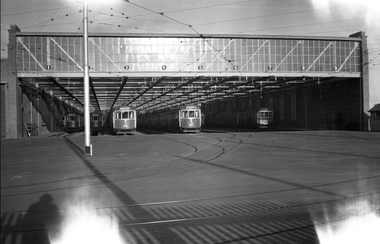 Melbourne Tram Museum
Negative, Wal Jack, 1938
Black and white negative, by Wal Jack, of the front of Brunswick Depot, during 1938; Trams (left to right) W5 772, 767, 771, C class 30, Q class 200. Dated in album as 1938.trams, tramways, brunswick, c class, w5 class, q class, brunswick depot, tram 772, tram 767, tram 771, tram 30, tram 200 -
 Eltham District Historical Society Inc
Negative - Photograph, J.A. McDonald, Reconstruction works, Research Oval, Jan. 1961
Looking north Early January 1961Record of various Shire of Eltham infrastructure works undertaken during the period of 1952-1962 involving bridge and road reconstruction projects, sometimes with Eltham Shire Council Project Reference numbers quoted. It was during this period that a number of significant improvements were made to roads and new bridges constructed within the shire that remain in place as of present day (2022). In many situations, the photos provide a tangible visible record of infrastructure that existed throughout the early days of the Shire. The album was put together by or under the direction of the Shire Engineer, J.A. McDonald.shire of eltham, 1961-01, infrastructure, reconstruction works, research (vic.), research oval -
 Eltham District Historical Society Inc
Negative - Photograph, Probably Jessica's Lane taken from Progress Road, Eltham North, 1998c
Roll of 35mm colour negative film, 8 strips and associated 10 x 15 cm colour printKodak Gold 100-5eltham north, jessica's lane, progress road -
Glenelg Shire Council Cultural Collection
Negative - Negative - Glenelg River, Victoria, c. 1934
Part of a collection of photographs taken by Zillah Maschmedt in 1934. Zillah was a teacher from South Australia.Transparency for black and white photo. View along Glenelg river at Nelson, Victoria. Township on right, bridge centre of the photo.zillah maschmedt, photography, glenelg river -
Glenelg Shire Council Cultural Collection
Negative - Glass Plate Negative - View of pastoral property from hill, 1890-1910
Stereoscopic glass plate negative. Image shows a view of pastoral property from hill. -
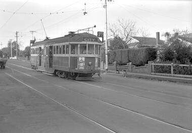 Melbourne Tram Museum
Negative, Travis Jeffrey, c1963
Negative of tram 219 at a tram stop. Tram has destination City and Route No 7. Photo looks staged as a school child in uniform leaning at door, driver and passenger in front window are all staring at the photographer. Note the tram has a trolley wheel fitted, the stop is a compulsory stop and that there is a light fitting above the tram with a tinted glass shield that indicated the type of stops at night. Possibly in Burke Road, between Leura Grove and Toorak Road.Paper folder that contained the negative had "NR99A" in red ink, "M5" in pencil, 58A in green ink, date stamp "1 Jan 1963" on front, and date stamp on rear "26 Sep 1962".trams, tramways, w2 class, route 7, tram stops, burke rd, tram 219 -
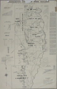 Federation University Historical Collection
Plan, Underground Survey of Mines, Ballarat, 1887
Printed plan with text down right side and black border, 4 holes top edge and repairsplan, underground survey, robert allen, w. langtree, prince of wales and bonshaw united, bonshaw, south plateau, north plateau, sebastopol plateau, sebastopol star, star of the east, south star, band and albion, owen's freehold, leigh river, yarrowee creek, robert allan, gay's freehold -
 Eltham District Historical Society Inc
Negative - Photograph, J.A. McDonald, Heidelberg-Kinglake Road, Mar. 1960
Job 56M431 Bridge handrails March 1960 Line Foreman Dan Boyd (PMG) Contractor W.E. WolfRecord of various Shire of Eltham infrastructure works undertaken during the period of 1952-1962 involving bridge and road reconstruction projects, sometimes with Eltham Shire Council Project Reference numbers quoted. It was during this period that a number of significant improvements were made to roads and new bridges constructed within the shire that remain in place as of present day (2022). In many situations, the photos provide a tangible visible record of infrastructure that existed throughout the early days of the Shire. The album was put together by or under the direction of the Shire Engineer, J.A. McDonald.infrastructure, 1960-03, bridge construction, cherry tree road, heidelberg-kinglake road, road construction, shire of eltham -
Moorabbin Air Museum
Plan (item) - C.A.C Turbojet Trainer Rolls Royce Derwent X.P.60. P271