-
 Glenelg Shire Council Cultural Collection
Plan - Plan - Port of Portland Slipway Fishing Vessel 'Gypsy Rose', 20/09/1983
port of portland -
Moorabbin Air Museum
Plan (Item) - Drawing Exterior Emergency Marking - Inboard & Outboard Nacelles Orion P3-B Aircraft Drawing No. A16194 Sheet 5 Of 5 Sheets
-
Glenelg Shire Council Cultural Collection
Plan - Plan - CRB concrete handrail, n.d
Port of Portland Authority Archivesport of portland archives -
 Queenscliffe Maritime Museum
Plan - Proposed option for housing for the QUEENSCLIFFE, Vacant Council Depot at Queenscliffe, unknown
Queenscliffe lifeboat housing optionOption to house the QUEENSCLIFFEPlan of vacant council depot proposed to house the QUEENSCLIFFE in 2-partsReverse - " nil ".historical references -
University of Melbourne, Burnley Campus Archives
Plan, Plan of Gardens, c. 1940?
Hand drawn plan of Gardens with some colour, on reverse of unused Certificate. Shows paths and beds in Ornamental Garden with grids drawn in pencil for planting lists. 2 photocopies of enlarged portion.Plan is drawn on verso of unused Diploma certificate from Royal Horticultural School Burnley, Department of Agriculture Victoria, with illustration of old Pavilion. On reverse, "Mr Kneen, Principal School of Horticulture Burnley," handwritten in pencil.ornamental gardens -
University of Melbourne, Burnley Campus Archives
Plan, The Heyington Diversion
yarra, river, freeway -
Port Melbourne Historical & Preservation Society
Plan - Side balcony, Port Melbourne Town Hall, Port Melbourne City Council, 1916
Plan - Details of side balcony, doors and main windows (1915 Town Hall).port melbourne town hall -
University of Melbourne, Burnley Campus Archives
Plan, Richmond Park, 1926-1954
Photocopy of Section of a Survey Plan 1926 showing fencing and hedging dated 1927. Stamp, Department of Lands and Survey 8.9.54 Neg 18378 See F? 71331(4?). From the Dept of Lands and Survey.Part of handwritten notes signed "Mr Anderson ? 28/2/45."parks, richmond -
University of Melbourne, Burnley Campus Archives
Plan (Item) - Landscape design, Landscape Design Plant List & Graphic interpretation - For?
amy willis, landscape design -
University of Melbourne, Burnley Campus Archives
Plan, Plan of Burnley Gardens, c.1940
Layout of Burnley Gardens in colour wash and ink. Framed and glazed. (Also unframed B11.0360.)burnley gardens -
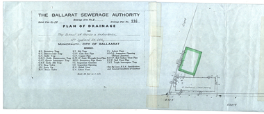 Federation University Historical Collection
Plan, Ballarat School of Mines Plan of Drainage, 1980?
Photocopied Sewerage Plan for Albert Street Scale 1: 480ballarat school of mines, ballarat sewerage authority, museum, welding shop, machine shop, ballarat junior technical school, plumbing -
Port Melbourne Historical & Preservation Society
Plan - Conceptual Perspective Drawings, Port Melbourne Yacht Club, Taylor Howden Pty Ltd, Architects, 1990s
Port Melbourne Yacht Club .01 - 02 Clubhouse reconstruction conceptual perspective drawings sport - yachting, built environment - recreational facilities -
Glenelg Shire Council Cultural Collection
Plan - Town Plan - Cape Bridgewater, 02/04/1992
Black and white photocopy of an old plan of a subdivision at Cape Bridgewater. Two halves joined together with sellotape. Black texta numbers on some of the lots 1 - 28Front: 'OLD MAP' handwritten, top edgeplan, town planning, cape bridgewater -
Glenelg Shire Council Cultural Collection
Plan - Plans / Line Drawing Port of Portland Slipway Twin Screw Tug 'Kalimni', 16/03/1981
Front: '14' - black texta, top right cornerport of portland -
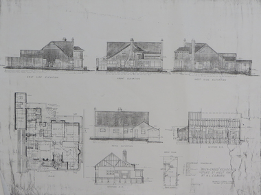 Federation University Historical Collection
Plan - Plan (copy), 'Brick cased Residence 1515 Sturt Street West for Mrs H.L. Coburn, by H. Leslie Coburn, not dated
Ballarat born Herbert L. Coburn grew up to be a renowned Ballarat architect, practising from 1905 to 1956. He taught Architecture and Building Construction at the Ballarat School of Mines (SMB) from 1918, resigning in 1948 due to ill health.Copy of a plan by H.L. Coburn. It includes a front, west, east and rear elevation; ground plan, block plan; and layout plan. herbert l. coburn, h.l. coburn, coburn, architecture, herbert coburn, architectural plan -
University of Melbourne, Burnley Campus Archives
Plan, Victoria University of Technology Melton Campus, 1994
Photocopy of 'Feature and Level Survey' plan by WBCM group. Job No 4776/5 Sheet 1 of 1. Compilation Sheet Part of 477630A and 477631A. Dated 06.07.1994. Drawn b y RVvictoria university of technology, melton -
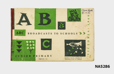 Whitehorse Historical Society Inc.
Education kit - Broadcast Book, ABC Broadcast for Schools, 1960's
Used 1960School broadcast bookClass Book III and IV Broadcast to Schools, Junior Primary. -
Moorabbin Air Museum
Plan (item) - Bristol Aeroplane 170 schematic drawings, Installation - Hydraulic Converter
Bristol Aeroplane Company Ltd -
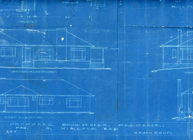 Ringwood and District Historical Society
Plan, Architects plan for residence in Balfour Avenue, Heathmont for Stan Wieland , no date
Stanley Wieland took over the property called "Fairview" at the corner of Dickasons Road and Canterbury Road, Heathmont after his Father's death in 1945. He married Thelma Wilson in 1930. Their daughter Pat wrote the Wieland History with her husband Don Talbot.Architect's plan on heavy blue paper for residence at Balfour Avenue , Heathmont -
Moorabbin Air Museum
Plan (item) - Bristol Aeroplane 170 schematic drawings, Special Washer ...Centre Plane.Title partly indechiperable
Bristol Aeroplane Company Ltd -
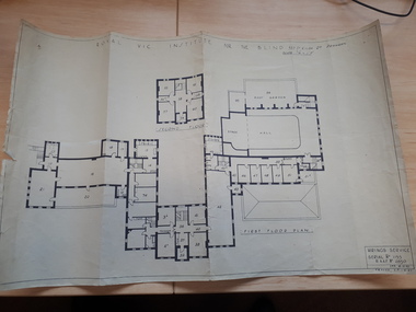 Vision Australia
Plan - Image, Royal Vic Institute for the Blind Hirings Service, 18/12/1943
Plan of the first and second floors of the main building at 557 St Kilda Road, created by the RAAF during it's occupation of the same between 1942-1944.1 architectural plan of St Kilda Road main buildingroyal victorian institute for the blind, plans, raaf -
Moorabbin Air Museum
Plan (item) - Bristol Aeroplane 170 schematic drawings, Assy. Real Spar Starboard
Bristol Aeroplane Company Ltd -
Glen Eira Historical Society
Plan - Centre Road, Bentleigh
Two copies of a one page printed advertisement for the auction of six shops on Centre Road, Bentleigh near Jasper Road to be held on 07/03/1950. The advertisement includes a plan (51mm x 127mm) of the sitesmeldrum w, centre road, bentleigh, plans, advertisements -
University of Melbourne, Burnley Campus Archives
Plan, Jordan Hansen, David Aldous Turf Memorial Garden Landscape Concept Plan, 2016
Landscape Concept Plan designed by Jordan Hansen for Andrew Smith LCP-001 David Aldous Turf memorial Garden 2016 - page 18. Scale 1:100andrew smith, jordan hansen, landscape design -
Glenelg Shire Council Cultural Collection
Plan - Plan - subdivision at Cape Bridgewater, 02/04/1992
Black and white photocopy of an old plan of a subdivision at Cape Bridgewater. In two halves, not joined together. Black texta numbers on some of the lots 1 - 28town planning, residential, cape bridgewater -
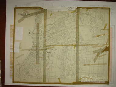 Federation University Historical Collection
Plan, Ballarat East, 1916, 24/05/1916
Plan of streets and allotments in Ballarat East. Includes: Bakery Hill, Canadian Station, Eureka Cemetery, Orphan Asylum, Eureka Gardens and Reserve, Gun Clubballarat east, bakery hill, eureka stockade site, eureka gardens, ballarat orphanage -
 Kew Historical Society Inc
Plan - Subdivision : Cotham and Glenferrie Roads, J R Mathers & McMillan
The Kew Historical Society's map collection includes a substantial number of real estate subdivision plans, mainly of Kew but also of surrounding suburbs in Melbourne. Most of the subdivision plans date from the 1920s and 1930s when the districts old homes and local farmland were being split up to accommodate residential growth in the postwar period. These early plans were assembled by a local firm, Jas R Mather & McMillan, which had an office in Cotham Road. Many of the plans, and sometimes photos, were annotated by the agents.Subdivision plans are historically important documents used as evidence for the growth of suburbs in Australia. They frequently provide information about when the land was sold as well as evidence relating to surveyors and real estate and financial agents. The numerous subdivision plans in the Kew Historical Society's collection represent working documents, ranging from the initial sketches made in planning a subdivision to printed plans on which auctioneers or agents listed the prices for which individual lots were sold. In a number of cases, the reverse of a subdivision plan in the collection includes a photograph of a house that was also for sale by the agent. These photographs provide significant heritage information relating house design and decoration, fencing and household gardens.The photograph may also be aesthetically significant depending on the importance of the photographic atelier.An undated and untitled hand-drawn and coloured subdivision plan detailing the boundaries of a number of irregular allotments bordering Cotham Road, Glenferrie Road and Stirling Avenue (now Stirling Street). The plan predates the actual subdivision that led to the creation of the eight commercial properties occupying 118-132 Cotham Road. The plan may represent an old subdivision that was further subdivided at a later date, or it may be a subdivision that never eventuated. On MMBW Detail Plan 1575 (1903), the area represented by the proposed subdivision was residential rather than commercial. The irregularity of lots is also apparent in the MMBW Plan. The largest of the unnumbered blocks on the hand-drawn subdivision plan may relate to the boundaries of the nineteenth century mansion identified as ‘Kelso’ on the MMBW Plan.subdivision plans - kew, cotham road - kew,, glenferrie road - kew , stirling avenue street - kew -
 Kew Historical Society Inc
Plan - Subdivision Plan, J R Mathers & McMillan, Heart of Richmond Estate : Richmond, 1928
"In 1928 the land on the east side of Johnson Street was subdivided in 60 lots for the ‘Heart of Richmond Estate’. The houses in the subdivision, along the east side of Johnson Street, and in the newly created Hollick, Cole and Kennedy streets were constructed from 1928 to 1937." (Source: City of Yarra Heritage Gaps Review One 2013)Portion of subdivision plan pasted on to cardboard. Area includes Johnson Street, Victoria Street, Kennedy Street, Cole Street, Hollick Street, Bennett StreetTitle Certificate Vol.2381, Folio 476130 Phillips, Fox & Masel, 440 Little Collins Street, Melbourne (Local estate agent: Jas. R. Mathers & McMIllan, 136 Cotham Road, Kew)subdivision plans - richmond (vic.), heart of richmond estate -
Port Melbourne Historical & Preservation Society
Plan - Annotated and handcoloured by Peter Libbis to indicate his research into Libbis family residences and hotels on copy of a section of an MMBW map, Melbourne and Metropolitan Board of Works, c. 1980s
Peter LIBBIS obtained these copies from the MMBW when he researched his family history in the 1980s. He has annotated them, colour in hotels etc. Donated to Society in 1997.One of a group of 19 photocopies of various 20th century MMBW plans, annotated/coloured in to indicate residences of Libbis family and local hotels, by Peter LIBBIS in family and hotel research - Bay/Crockford area, Ingles to Bridgebusiness and traders - hotels, built environment - domestic, transport - railways, melbourne and metropolitan board of works, libbis family -
Glenelg Shire Council Cultural Collection
Plan - Plans / Line Drawings - Port of Portland Authority Slipway vessel Atlantic Clipper, Portland, Victoria, 11/11/1986
PORT OF PORTLAND AUTHORITYFront: 'Deadline PM. WED 3rd DEC JOB NO 3008' BLACK PEN, BOTTOM LEFT '20' - black texta, top right corner