-
 Eltham District Historical Society Inc
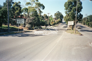
Negative - Photograph, Main Road, Eltham, c.Dec. 1983
Road sign advising of proposed reconstruction works of Main Road to install a roundabout at Mount Pleasant Road. Traffic to Lower Plenty and Templestowe to be diverted down Bridge Street (and Bolton Street) effective January 1984. The proposed roundabout did not proceed. Instead traffic islands on Mount Pleasant Road were installed in place of temporary blocked out islands.Film - Kodak CM 400 5079 7 strips, 26 framesinfrastructure, roads, road construction, roundabout, road sign, main road, mount pleasant road -
 Clunes Museum
Negative - NEGATIVE PLATES
Negatives taken and owned by Carl Weickhardt, grandson of Johannes, Son of Jacob (Tank Maker)10 Glass Negative Plates in a box with a note "our grandparents D & K Patience" .1 Weickhardt Tanks .2 Fire Brigade .3 David and Kate Patience .4 Ballarat Bakery (Clunes) .5 Montage of F Weickhardt .6 Tank on a lorry .7 Tank .8 Clunes North School .9 Aeroplane landing .10 Aeroplane landingOn box; Kodak, Abbotsford, Melbournenegatives, patience, tanks, kodak -
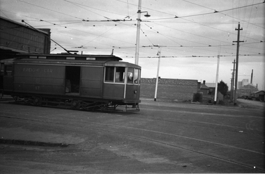
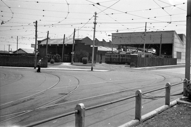
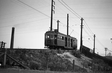
 Ballarat Tramway Museum
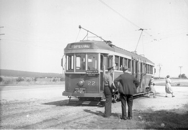
Negative, Wal Jack, 14/03/1949 12:00:00 AM
Yields information about the use of the bogie cars on a tour for the AETA and the appearance of the Sebastopol terminus.Negative and Digital image of the Wal Jack Ballarat Negative file of No. 22 at the Sebastopol terminus running an AETA special, mid to late 1940's. Note the lack of housing behind the tram. Dated by G.Cleak - 14.3.1949 - Labour Day. Reg item 6764 has a photo of No. 22 at the depot.trams, tramways, aeta, tours, sebastopol, tram 22 -
 Queenscliffe Maritime Museum
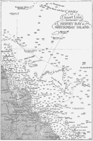
Map - B & W coastal map between Hervey Bay & Whitsunday Island, in Queensland, Coastal map, Queensland, between Whitsunday Island & Hervey Bay, Before donation in 1987
Australian coastal mapsAustralian coastal mapsCoastal 'soundings' map between Hervey Bay & Whitsunday Island, in Queensland, from an unknown book, pre-1987Reverse " NIL "old maps of australian coast -
 Eltham District Historical Society Inc
Negative - Photograph, Probably John Street, Eltham, c.Mar. 1983
Roll of 35mm colour negative film, 4 stripsKodak Safety 5035john street, eltham, houses -
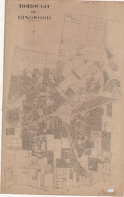 Ringwood and District Historical Society
Map, Borough of Ringwood, Victoria - c.1950s
A0-size (approx) linen-backed municipal engineer’s survey map of named streets and lot-numbered properties within Borough of Ringwood.Scale: 8 chains to 1 inch. -
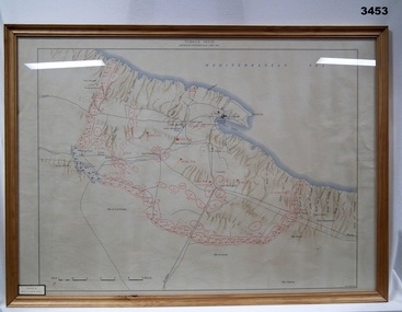
Whitehorse Historical Society Inc.
Map, Belgium WW1 map, Aug 1917
WW1 map of Belgium Edition 1. Sheet 28 S.W. and S.E. with trenches in red around the towns of Comines and Warnetonnon-fictionWW1 map of Belgium Edition 1. Sheet 28 S.W. and S.E. with trenches in red around the towns of Comines and Warnetonworld war 1914 - 1918, maps -
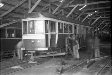 Ballarat Tramway Museum
Negative - Set of 2, Wal Jack, 1951
Yields information about the delivery of bogie trams form Melbourne and that became No. 38Set of two Negative and Digital images of the Wal Jack Ballarat Negative file of ex MMTB No. 41, being lifted or lowered on jacks within the Ballarat tram depot. Tram still has the white war time black out markings on the bumper and the front dash panel. The tram became No. 38. .1 - Beams either being readied for lifting of after lifting. Not sure what the jack under the bumper is doing. .2 - another view from further back in the depot. Reg Item 5551 has the arrival date of 1/5/1951trams, tramways, depot, new trams, bogie trams, tram 41 tram 38 -
 Eltham District Historical Society Inc
Negative - Photograph, J.A. McDonald, Removal of the remains of the Abraham house at Kangaroo Ground, c. May 1962
Martin Bros House Removing of Seaford was contracted to remove the remains of the storm damaged Abraham house from the property circa May 1962. The Abraham family owned land near the Aqueduct and east of Nicholas Lane at Kangaroo Ground (based on photos, at or near 40 Nicholas Lane).Record of various Shire of Eltham infrastructure works undertaken during the period of 1952-1962 involving bridge and road reconstruction projects, sometimes with Eltham Shire Council Project Reference numbers quoted. It was during this period that a number of significant improvements were made to roads and new bridges constructed within the shire that remain in place as of present day (2022). In many situations, the photos provide a tangible visible record of infrastructure that existed throughout the early days of the Shire. The album was put together by or under the direction of the Shire Engineer, J.A. McDonald.1962-05, abraham house, kangaroo ground, martin bros house removing seaford, nicholas lane, property damage -
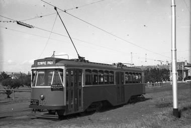 Melbourne Tram Museum
Negative, Wal Jack, mid 1950's
Black and white negative, by Wal Jack, Y1 610 of an AETA tour at Point Ormond, with destination of Olympic Park. Photo possibly mid 1950'strams, tramways, aeta tour, point ormond, y1 class, tram 610 -
 Melbourne Tram Museum
Negative, Wal Jack, 23/05/1941 12:00:00 AM
Black and white negative, by Wal Jack, of Freight car No. 17 at Brunswick Depot. Photo dated, 23/5/1941 in the Wal Jack album. See also Reg item 5238 for another photo of this car at Brunswick.trams, tramways, freight tram, brunswick, brill 21e, tram 17 -
Stawell Historical Society Inc
Map, Township of Moyston, Parish of Moyston, County of Borung, 1956
Township of Moyston, Parish of Moyston, County of Borungstawell -
Moorabbin Air Museum
Map (item) - TAA map of Australia & Papua New Guinea 10th edition
-
 Ringwood and District Historical Society
Map, Plan of Country Lands in the Parishes of Nunawading Ringwood and Scoresby - circa 1855
Blueprint copy of Survey Map detailing original Selectors' names and property locations. List of Parish map references including property bearings, distances in Links, and markings on trees. Descriptive remarks include areas marked "Farmer's Common", "Poor soil thickly/moderately timbered with stringy bark", and location of water and firewood reserves."Surveyed and plotted by N.M. Bickford, Superintendant of Mr. Hodgkinson's Field Party". "The land comprised in this survey is of inferior quality, moderately undulating, and thickly wooded. It is watered by Dandenong Creek and Deep Creek." Inset map showing location of (*proposed) cemetery on southern corner of Lillydale Road from Melbourne and Sawmill Road, later Mount Dandenong Road. (*Cemetery did not eventuate.) -
 Bendigo Military Museum
Map - MAP TOBRUK, FRAMED, Post 1941
Coloured map of Tobruk Seige. Lacquered wooden frame, glass front & cardboard backing.Printed top centre: “TOBRUK SEIGE, AUSTRALIAN POSITIONS AS AT 1ST MAY 1941” Donation sticker on bottom LHS. map, tobruk, seige -
Port Melbourne Historical & Preservation Society
Financial record - PMHPS, Pat Grainger, Annual Report 1996, Aug 1996
PMH&PS was incorporated in 1994, and from 1995 was required to hold an AGM and present an Annual Report. These were compiled, designed, printed on photocopier and bound by the Secretary, except for the Tenth anniversary edition.Annual Report of the PMH&PS, 1996 A5 8 pp plus cover - khaki, with photo of Town Hall, Contains financial reports, list of members and photo of recently demolished Missions to Seamen buildingsocieties clubs unions and other organisations, port melbourne historical & preservation society, pmhps, glen cosham -
Whitehorse Historical Society Inc.
Legal record - Document, Certificate of Title, 1920
Certificate of Title vol. 4395 fol. 878940, 25 November 1920, mortgage and rate notices for Lot 7 (410), Middleborough Road, owned by George GayCertificate of Title vol. 4395 fol. 878940, 25 November 1920, mortgage and rate notices for Lot 7 (410), Middleborough Road, owned by George GayCertificate of Title vol. 4395 fol. 878940, 25 November 1920, mortgage and rate notices for Lot 7 (410), Middleborough Road, owned by George Gaygay, george, shire of blackburn and mitcham, middleborough road blackburn, no.410 -
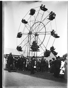 Wodonga & District Historical Society Inc
Negative - Haeusler Glass Negatives Collection - Ferris Wheel, c1910
The Wodonga Historical Society Haeusler Collection provides invaluable insight into life in late nineteenth and early twentieth century north east Victoria. The collection comprises manuscripts, personal artefacts used by the Haeusler family on their farm in Wodonga, and a set of glass negatives which offer a unique visual snapshot of the domestic and social lives of the Haeusler family and local Wodonga community. The Haeusler family migrated from Prussia (Germany) to South Australia in the 1840s and 1850s, before purchasing 100 acres of Crown Land made available under the Victorian Lands Act 1862 (also known as ‘Duffy’s Land Act’) in 1866 in what is now Wodonga West. The Haeusler family were one of several German families to migrate from South Australia to Wodonga in the 1860s. This digital image was produced from one of the glass negatives that form part of the collection, probably taken by Louis Haeusler (b.1887) with the photographic equipment in the Wodonga Historical Society Haeusler Collection.This item is unique and has well documented provenance and a known owner. It forms part of a significant and representative historical collection which reflects the local history of Wodonga. It contributes to our understanding of domestic and family life in early twentieth century Wodonga, as well as providing interpretative capacity for themes including local history and social history.Digital image created from the Haeusler Glass negative collection. A large group of people gathered in front of a Ferris wheel. Building labelled "Banquet Hall" is in the background. The location is not confirmed. C. 1910"Banquet Hall" on the building in the background.wodonga pioneers, haeusler family, glass negatives, dry plate photography, ferris wheel -
Whitehorse Historical Society Inc.
Map, Melbourne Geological Map, 1937
Geological Map of Melbourne & Suburbs.Geological Map of Melbourne & Suburbs. Scale: 40 chains to 1 inch with inset 10 miles to 1 inch. Includes Municipal and Parish boundaries, railways and stations, electric tramways, cable tramways, Post Offices and State schools. Area bounded by Braybrook, Preston, Blackburn & Brighton. Printed on linen.Geological Map of Melbourne & Suburbs. melbourne, maps -
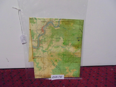 National Vietnam Veterans Museum (NVVM)
Map
A laminated coloured map of the Son River, Dang Nai, Vietnammap, 3rar, mcphail collection -
Glenelg Shire Council Cultural Collection
Negative - Negative - view of Glenelg River, Victoria, 1934
Part of a collection of photographs taken by Zillah Maschmedt in 1934. Zillah was a teacher from South Australia.Negative for black and white photo. Nelson Victoria. View across river looking towards mouth of the Glenelg River.zillah maschmedt, photography, glenelg river, nelson -
Ringwood and District Historical Society
Legal record - Fire Insurance document (C.E.Carter), Fire Insurance - Atlas Assurance Co Ltd for J. E. M. Williams, 1934
Standard form of Fire Insurance Policy issued by Atlas Assurance Company Limited, England.Policy issued to J. E. M. Williams for property in Main Street Ringwood, dated September 1934. -
 Melbourne Tram Museum
Negative, Wal Jack, 19/01/1941 12:00:00 AM
Black and white negative by Wal Jack of the then Preston Depot, Thornbury Depot from St Georges Road, 19-1-1941. A man in a white jacket is sweeping the curve track. Inside the new shed, trams W2 477? (showing City Route 9D), 644 (Thornbury Route 9) and 444 (Thornbury Route 9D)trams, tramways, preston depot, thornbury depot, st georges road, w2 class, route 9, route 9d, tram 477?, tram 644, 444 -
Koorie Heritage Trust
Education Kit, Aboriginal Affairs Victoria et al, Aboriginal Heritage Bill - Exposure Draft. (2005), 2005
Exposure draft; sets out the eight objectives of the proposed Act in the protection of Aboriginal cultural heritage in Victoria, strengthen the involvement of Aboriginal people in cultural heritage management; establish an Aboriginal cultural heritage registervii, 110 p. ; 30 cm. 10 information loose sheets; pamphlet folder 32 cm.Exposure draft; sets out the eight objectives of the proposed Act in the protection of Aboriginal cultural heritage in Victoria, strengthen the involvement of Aboriginal people in cultural heritage management; establish an Aboriginal cultural heritage registervictoria. parliament aboriginal heritage bill. | cultural property -- protection -- law and legislation -- victoria. | sacred sites (australian aboriginal) -- law and legislation -- victoria. | law - administrative law - victoria. | cultural heritage - protection. | cultural heritage - repatriation. | cultural heritage - repatriation - human remains. -
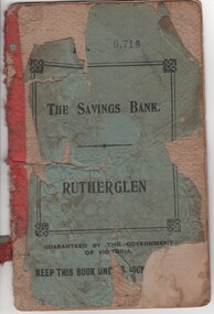 Rutherglen Historical Society
Financial record - Savings Book, The Savings Bank. Rutherglen, 1912-1913
Name of depositor: Mr Michael Maguire Part of a collection of business documents found under the floor of a building in Main Street when it was being renovated. At that time the owner was Don Chambers, and the premises was occupied as the Chambers Riteway Supermarket. The location (134 Main Street) is currently (2022) occupied by Miegel’s Pharmacy Rutherglen. Small savings bank record book, with a tattered green cover, for the Savings Bank - Rutherglen.This book numbered "6,718"maquire family, banking, savings accounts, bank documents, 134 main street, chambers riteway supermarket -
Port Melbourne Historical & Preservation Society
Financial record - Blank cheque, State Savings Bank of Victoria
Blank cheque from the State Savings Bank of Victoria c early 1900sbanking, state savings bank of victoria -
Port Melbourne Historical & Preservation Society
Financial record - Annual Statements, Port Melbourne Council, 1870 - 1911
Bundle of yearly account statements from Council 1870-1911local government - town of port melbourne, local government - borough of sandridge -
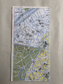 Robin Boyd Foundation
Map, Blondel La Rougery, Find Your Way in Paris, 1959
Map marking the Printemps department stores and significant urban landmarks in Paris; maps of Paris Metro and Autobus on reverse/ Blondel La RougerySmall scribbles on the advertising pages, indecipherable.paris, paristemp, map, transport map, walsh st library -
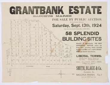 Bacchus Marsh & District Historical Society
Map - Land Sales Plan, Grantbank Estate Bacchus Marsh, 1924
The Grantbank Estate was a parcel of land close to the centre of the shopping area of Bacchus Marsh which was sub-divided and offered for sale in 58 lots on the 13th September, 1924. It comprised an area of 15 acres, being a portion of the Millbank Estate which had been in the hands of the Grant family for 75 years. The lots had frontages to Gisborne Road, Patterson, William and Sutherland Streets. This was a significant sub-division of land and represented a major expansion of residential housing in Bacchus Marsh in the early 20th century.This land sale map is a typical example of housing estate land sales advertising maps produced by real estate agents in this era. The map is significant for the detailed information it provides about when and where land was sold for new housing estates in Bacchus Marsh in the early twentieth century.Printed paper mapland sales bacchus marsh, land subdivsion bacchus marsh, housing estates land sales bacchus marsh, grant family bacchus marsh -
 Melbourne Tram Museum
Negative, Wal Jack, 19/01/1941 12:00:00 AM
Black and white negative by Wal Jack of W2 522 (East Preston Route 9) on The Hump track at Preston Workshops over the Whittlesea line. Photo dated 19-1-41trams, tramways, the hump, w2 class, route 9, tram 522