-
 Stawell Historical Society Inc
Map, Plan of Stawell Vineyard (Bald Hills), c1896
Plan of Stawell Vineyard (Bald Hills)stawell, wine -
Tatura Irrigation & Wartime Camps Museum
Literary work - Autobiography, John Malcolm WELLER, 1970
An excerpt from the autobiography written in the 1970's by John Malcolm WELLER. a guard in Camp 13 and Graytown in 1942-1945. Clear front, grey back and side plastic folder containing 8 sheets of an excerpt from the autobiography of John Malcolm WELLERon side: donors name and address; Record of "Saddler Weller army guard at Camp 13 and Graytown 1942-1945.john malcolm weller, saddler weller, camp 13 murchison, graytown internment camp, army guards internment camps -
![Parish of Nunawading, County of Bourke showing land acquired under Closer Settlement Acts [C 1887]](/media/collectors/56f368632162f118acbff12e/items/60d923316e5f99545134f182/item-media/6147b12a4806c7ae686c24e4/item-fit-380x285.jpg) Whitehorse Historical Society Inc.
Whitehorse Historical Society Inc.Map, Parish of Nunawading, ca 1887
Parish of Nunawading, County of Bourke showing land acquired under Closer Settlement Acts [C 1887]Parish of Nunawading, County of Bourke showing land acquired under Closer Settlement Acts [C 1887] 1947 reprint.Parish of Nunawading, County of Bourke showing land acquired under Closer Settlement Acts [C 1887] parish of nunawading, box hill, maps, land settlement -
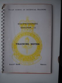 Moorabbin Air Museum
Education kit (item) - Reciprocating Engines - 11 Training Notes, RAAF School of Technical Training
-
Clunes Museum
Map
.1 - .4 DETAILED MAP OF CLUNES BY F.C.W. .5 MAP OF CLUNESlocal history, documents, maps, maps -
Stawell Historical Society Inc
Map, Ledcourt, County of Borung, Shire of Stawell, 1957
Ledcourt, County of Borung, Shire of Stawellstawell -
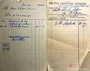 Melton City Libraries
Financial record, Scots Church Invoices, 1964,1967
Invoices for Scots Church, Melton. The one on the right is from Jongebloed Hardware storechurches -
 Federation University Historical Collection
Map, Sunbury, 1938
Printed colour map on papersunbury -
Bendigo Historical Society Inc.
Map - INFANCY OF BENDIGO, Original dated 28/10/1890
Map: Photocopy of the First sketch map of the Bendigo Diggings. Has been assembled from several photocopies taped together. Laid before the Frencham Committee by William Sandbach , a witness, 18 September 1890. There are Two of these maps. ( x ref 5673 , 8235 , Box 83 , 9077 )map, bendigo, city streets, infancy of bendigo, gold diggings, henry frencham, william sandbach, where was gold first found -
 National Vietnam Veterans Museum (NVVM)
Map
Highly detailed map of Vietnam on parchment from Fwouc Tho Province. Map is waterproof.map, peter lewis -
Port Melbourne Historical & Preservation Society
Financial record - PMHPS, Pat Grainger, Annual Report 2011, Aug 2011
PMH&PS was incorporated in 1994, and from 1995 was required to hold an AGM and present an Annual Report. These were compiled, designed, printed on photocopier and bound by the Secretary, except for the Tenth anniversary edition and most recent edition, commercially photocopied.Annual Report of the PMH&PS, 2011 A5 Navy colour with red printing and photo of Port Melbourne Football Club. Contains financial reports, list of members and photossocieties clubs unions and other organisations, port melbourne historical & preservation society, pmhps -
Lakes Entrance Regional Historical Society (operating as Lakes Entrance History Centre & Museum)
Financial record - Ledger, Country Roads Board Wages Ledger, 18050
Entries in ink and hand written, all pages used, leather bound foolscap sizeA Ledger of Wages paid to Country Roads Board employees of East Gippsland Victoriaaccounts book -
Bendigo Historical Society Inc.
Map - CAMPBELL COLLECTION: BENDIGO & DISTRICT MAPS, 14-6-29
Map. Eppalock, Sedgwick and Strathfieldsaye. Scale 20 chains to 1 inch. Total area 3972 acres. Prepared in W.P.B. from Assessment Plan and Parish Plans. H.A. Darby. (number 378 in map cupboard 1)H.A.Darbymap, bendigo, agricultural lands -
Bendigo Historical Society Inc.
Map - PARISH OF SANDHURST 1961, 1961
At Bendigo Parish of Sandhurst. Sheet 13Dept of Lands and Surveybendigo, land sales, parish map -
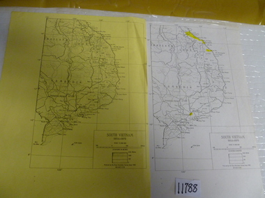 National Vietnam Veterans Museum (NVVM)
Map, 1983 (exact)
Two maps of South Vietnam dated 1954-1975. One on plain paper, one on yellow papermaps, south vietnam -
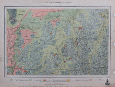 Federation University Historical Collection
Map, Geological Survey of Victoria, 1913
Printed colour map on papervictoria, geological survey of victoria, gladstone, talbot -
Bendigo Historical Society Inc.
Map - CAMPBELL COLLECTION: BENDIGO AND DISTRICT MAPS, 8-6 29
Map. Kimbolton, Parishes of Kimbolton and Lyell, scale 20 chains to 1 inch. Area by Plamimeter 6258 acres. Coliban River, Knowsley, Strathfieldsaye 10 1/2 miles. Prepared in W.P.B. from Parish and Assessor's Plans. G.W.Latimer 8-6-29. (number 393 in map cupboard 1)G.W.Latimermap, bendigo, allotments -
Stawell Historical Society Inc
Map, Riachella, County of Borung, Shire of Stawell, 1920
Riachella, County of Borung, Shire of Stawellstawell -
Glen Eira Historical Society
Map - Brighton Cemetery, North Road, Caulfield South
Photocopy of a typed letter from the National Trust (Victoria), dated 23/10/1997, to Brighton Cemetery Trust, notifying of the classification o the cemetery in the National Trust Register. An undated photocopy of a map and plan of Brighton Cemetery.brighton cemetery, north road, caulfield south, burke chris, brighton cemetery trust, sheffield road, hawthorn road, cemeteries, grave yards -
Bendigo Historical Society Inc.
Map - TARNAGULLA, Examined May 1883
Map: Tarnagulla, Counties of Gladstone and bendigo. Parish plan ( number 244 in Map Cupboard 1)map, gladstone, parish plan, tarnagulla, gladstone -
 Moorabbin Air Museum
Map (item) - Commonwealth of Australia Visual Charts, VEC (various), Terminal Chart (Various)
-
 Warrnambool and District Historical Society Inc.
Map - Fire Maps, Region 5 Fire Control Map, 1963
Two fire maps of south west Victoria.1 This is a rectangular piece of linen folded several times to form a packet with the front part covered with a brown card. The cover has a blue and white label. The map has a white base with red and green markings and red and black printing .2 As .1 abovenon-fictionTwo fire maps of south west Victoriafire maps, warrnambool history -
Bendigo Historical Society Inc.
Map - STRUGNELL COLLECTION: BENDIGO GOLD FIELD GEOLOGICAL SURVEY, 1936
Bendigo Goldfieds Geological Survey. Prepared in the Bendigo Office Bottom Section of original map.Dept of Mines Victoriabendigo, gold mining, geological map -
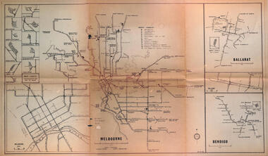 Melbourne Tram Museum
Map - Melbourne - Ballarat - Bendigo Tramways, 23-9-1969
Provides a detailed map of Melbourne, Ballarat and Bendigo tram lines - dated 23-9-1969. Shows street names, depot locations, depot layouts, track details including an insert for Sturt St Ballarat and destination locations. Provides a scale for each system. Not known who prepared the drawing.Yields information about the three operable Victorian systems at the date of preparation.Printed - dyeline? map on a folded sheet of papermap, melbourne, ballarat, bendigo, tramways, diagram -
Bendigo Historical Society Inc.
Map - HUSTLER'S REEF & HUSTLER'S REEF NO 1 MINES - PLAN OF THE HUSTLER'S REEF & HUSTLER'S REEF NO 1 MINES
Plan of the Hustler's Reef & Hustler's Reef No 1 Mines on the Hustler's Line of Reefs Bulletin No 33, Plate No XVII. Two drawings with different levels on each for clarity. Shows depth and some geographical features.Geological Survey of Victoria emblem. Signed by H A Whitelaw Underground Survey Office Bendigo, September 1913. This item has not been scanned or photographed.mining, parish map, hustler's reef & hustler's reef no 1 mines, plan of the hustler's reef & hustler's reef no 1 mines, hustler's line of reefs, geological survey of victoria, underground survey office bendigo, h a whitelaw -
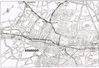 Bendigo Historical Society Inc.
Map - MAP OF CENTRAL BENDIGO
Map of Central Bendigo, RACV Copyright (no date - but RACV Branch Office is shown as being at View Point). Black & White Copy. Showing road and rail system and prominent features of City landscape.RACV Copyright.map, bendigo, city streets, long gully, north bendigo, golden sqyare, specimen hill, iron bark. -
 Bendigo Historical Society Inc.
Map - FORTUNA HUSTLER'S MINE - LONGITUDINAL SECTION OF THE FORTUNA HUSTLER'S MINE
Longitudinal Section of the Fortuna Hustler's Mine on the Hustler's Line of Reef, Bendigo. Bulletin No 33, Plate No IV. Shows poppet legs at the surface level, Datum Line 750 feet above Sea Level, levels and their depths, the amount of gold per ton and some geographical features. Geological Survey of Victoria emblem and signed by H A Whitelaw, Underground Survey Office, Bendigo. Note - Plates 4, 8, 13, 20, 26 & 31 form a Longitudinal Section from Fortuna Hustler's to Hustler's Consols Mine. This item has not been scanned or photographed.mining, parish map, fortuna hustler's mine, longitudinal section of the fortuna hustler's mine, geological survey of victoria, h a whitelaw, underground survey office bendigo, hustler's line of reef, hustler's consols mine -
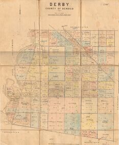 Bendigo Historical Society Inc.
Map - JACK FLYNN COLLECTION: DERBY, 1/09/1909
Map: Derby, County of Bendigo. Parish plan.Dept of Lands and Survey, Melbourne by T.E.McGauran 1.9.09map, bendigo, parish plan, derby -
Stawell Historical Society Inc
Map - Drawings, Wendy Jacobs, Wester Highway Community Precinct Development Hydrolic Services, 2014
Used in Building Historical Society BuildingTwo (2) A1 Printed Plans Hydrolic ServicesDrawing No. H100 Rev C1 July 2014. Drawing No. H101 Rev C1 July 2014 -
Bendigo Historical Society Inc.
Map - PANNOOMILLOO, 21/06/1882
Map: Pannoomilloo, County of Bendigo. Parish plan (number 282 in map cupboard 1)map, bendigo, parish plan, pannoomilloo