-
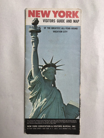 Robin Boyd Foundation
Map, New York Convention and Visitors Centre, New York Visitor Guide and Map: Of the Greatest All-Year-Round Vacation City, 1966
new york city, map, walsh st library -
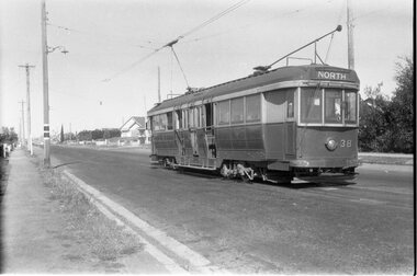 Ballarat Tramway Museum
Negative - Geelong Belmont terminus tram 38, early 1956
Photo shows Geelong No. 38 at the Belmont terminus, High Street with the return destination of North. Note the compulsory tram stop on the left-hand pole. One of a set of photos was taken between 15/2/1956 and 3/3/1956 when services operated only between Belmont and North before the final closure of the Belmont route on 25/31956 and that bogie tram 31 is not shown on the board, having gone to Ballarat on 15/2/1956 - see item 5554. See item 8213 for an article on the Geelong system by Keith Kings. Yields information about the Belmont tram terminus prior to closure.Black and white Negative - 120 sizetram stops, tramways, high st, geelong, tram 38, belmont -
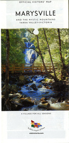 Marysville & District Historical Society
Map (Item) - Map and touring guide, Murrindindi Regional Tourism Association Inc, MARYSVILLE AND THE MYSTIC MOUNTAINS YARRA VALLEY-VICTORIA, Unknown
A fold out map and touring guide of Marysville and the surrounding district published by Murrindindi Regional Tourism Association Inc.A fold out map and touring guide of Marysville and the surrounding district published by Murrindindi Regional Tourism Association Inc.marysville, victoria, australia, map and touring guide, the cumberland, murrindindi regional tourism association inc, abbey green b&b, amberview lodge, anastasia fairytale cottage, ashlar cottage b&b, blackwood cottages, camellia log cabin, crossways country inn, dalrymples guest cottages, eagle mountain retreat, esa camping and conference centre, fruit salad farm, gilberts restaurant, keppels hotel motel, kerami house, kooringa resort and conference centre, lomatia lodge, lyelll guest cottages, marylands country house, marylyn holiday resort, marysville caravan park, marysville visitor information centre, alpacas at carmyle farm, australian adventure experience, bruno's art and sculpture garden, buxton trout farm, country touch tours, lake mountain, lake mountain ski hire, manical mechanicals, marysville district country club, marysville ski centre, rubicon valley horse riding, things of sand & stone, clearstream olives, the old woolshed cafe, fraga's cafe restaurant, lake mountain resort bistro, mantirri blueberry farm, gallipoli park, keppels lookout, cambarville, lady talbot drive, cathedral range state park, steavenson falls, steavenson river, taggerty river, acheron river, marysville auto and hardware, marysville newsagency & general store, narbethong visitor information centre, visit victoria -
 Glenelg Shire Council Cultural Collection
Negative - Glass Plate Negative - Whalers Bluff Portland, 1890-1910
Glass plate negative. Image looking south to Whalers Bluff, with lighthouse and flagstaff. c 1890-1910 -
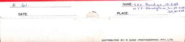 Ballarat Tramway Museum
Negative, Brian Andrews, Folder No. 61 - 35mm - SEC Bendigo and Glenelg, 15-3-1968
Contains part of the negatives that the photographer took of Bendigo and its tramway system on a 1968 visit. For the actual prints see the Album 8637 and the digital images held in the Museum's photo collections files. Many of the photographs were used in Brian's book, "By Birney to Golden Square" Includes as well 12 photographs of track work on the Glenelg Adelaide tram line.Demonstrates the work of Brian Andrews.Negative folder - paper folder by R. Gunz (Photographic) Pty Ltd containing 6 strips of 35mm negatives in a plastic clear sleeve.Folder No. 61 - 35mm - SEC Bendigo and Glenelg - MTT Glenelg line 24-3-68 and 30-3-68trams, tramways, brian andrews, negatives, bendigo, glenelg -
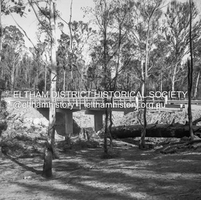 Eltham District Historical Society Inc
Negative - Photograph, J.A. McDonald, Henley Road Bridge at Watsons Creek, c. May 1962
Completed early January 1962Record of various Shire of Eltham infrastructure works undertaken during the period of 1952-1962 involving bridge and road reconstruction projects, sometimes with Eltham Shire Council Project Reference numbers quoted. It was during this period that a number of significant improvements were made to roads and new bridges constructed within the shire that remain in place as of present day (2022). In many situations, the photos provide a tangible visible record of infrastructure that existed throughout the early days of the Shire. The album was put together by or under the direction of the Shire Engineer, J.A. McDonald.1962-05, bend of islands, bridge construction, henley road, henley road bridge, infrastructure, kangaroo ground, oxley bridge, road construction, shire of eltham, watsons creek -
University of Melbourne, Burnley Campus Archives
Map, Map of Showgrounds, c. 1970
Tracing paper plan with grid lines.showgrounds -
 National Vietnam Veterans Museum (NVVM)
Map
A laminated coloured map of the Son River, Dang Nai, Vietnammap, 3rar, mcphail collection -
 Eltham District Historical Society Inc
Negative - Photograph, J.A. McDonald, Eltham, Haldane Road, Mar. 1961
Dr Donald Thomson's gate and entrance to his property 'Worlingworth' after flooding in March 1961 "Worlingworth", Eltham, was the home of noted anthropologist the late Professor Donald Thomson and his wife Dorita. The entrance gate on Banoon Road is located at the bottom of the hill opposite Haldane Road. The flooding issues were regularly reported to Council following heavy rain. Google Street View Feb 2014 https://goo.gl/maps/SGjsJAAEdjQXgo5V9Record of various Shire of Eltham infrastructure works undertaken during the period of 1952-1962 involving bridge and road reconstruction projects, sometimes with Eltham Shire Council Project Reference numbers quoted. It was during this period that a number of significant improvements were made to roads and new bridges constructed within the shire that remain in place as of present day (2022). In many situations, the photos provide a tangible visible record of infrastructure that existed throughout the early days of the Shire. The album was put together by or under the direction of the Shire Engineer, J.A. McDonald.infrastructure, shire of eltham, 1961-03, flood damage, haldane road, prof donald thomson, worlingworth -
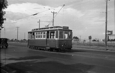 Ballarat Tramway Museum
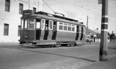
Negative, Wal Jack, early 1950's
Negative and Digital images of the Wal Jack Geelong Negative file of Geelong 2 at the North terminus. Photo early 1950's.. trams, tramways, geelong, north, tram 2 -
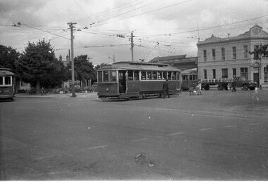 Ballarat Tramway Museum
Negative, Wal Jack, late 1940's or early 1950's
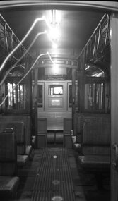
Yields information about the tram services and the way they could co-ordinate at Hospital Corner and other traffic.Negative and Digital image of the Wal Jack Ballarat Negative file of three trams at Hospital corner. No. 20 has turned from Drummond North in Sturt - City No. 21 from Sturt in Drummond North - Gardens via Drummond North No. 15 in Sturt St for Gardens via Sturt St west. In the background is the Southern Cross Hotel. There is a lady with a pram and beer delivery truck.trams, tramways, hospital corner, sturt st, drummond st, tram 20 tram 21 tram 15 -
 Ballarat Tramway Museum
Negative, Wal Jack, 1951
Yields information about tram 23 and its internal appearance with the internal flip over backed seats.Negative and Digital images of the Wal Jack Ballarat Negative file of the interior of Ballarat 23, possibly after it has been withdrawn from service. Shows the interior former Adelaide tip over seats, Brill-Winner type seating. See btm7873doc.pdf for a series of emails from Warrington Cameron 7/2020 identifying and discussing the photograph.trams, tramways, interiors, ballarat depot, gold, centenary of gold, tram 23 -
 Ballarat Tramway Museum
Negative, Wal Jack, early 1950's
Negative and Digital images of the Wal Jack Ballarat Negative file of Geelong 21 at the West terminus with the Telegraph Hotel in the background. The tram has the destination of East in the rear canopy and the West in the side destination. The adjacent pole has the End of section sign and the painted markings.trams, tramways, geelong, west, signs, tram 21 -
 Bacchus Marsh & District Historical Society
Map, Lerderderg District Proposed Irrigation and Water Supply Trust (A). Plan showing boundaries of Trust District
The 1886 Irrigation Act in Victoria introduced the first legislation in Australia designed to enable the creation of a detailed scheme for agricultural irrigation. Part of the legislation saw the use of government funds for local irrigation projects. These local projects were managed by local irrigation trusts. The Lerderderg Irrigation and Water Supply Trust] was formed in 1890. This map depicts the proposed area of the Trust.Printed paper map of the proposed Lerderderg District Irrigation and Water Supply. Plan showing boundaries of Trust District. The Lerderderg District lies within the Parishes of Korkuperrumul and Merrimu in the County of Bourke. At the top of the map above its title is the letter 'A; in capital lettering. Scale: 40 Chains = 1 inch.irrigation, water supply, lerderderg irrigation and water supply trust -
 Melbourne Tram Museum
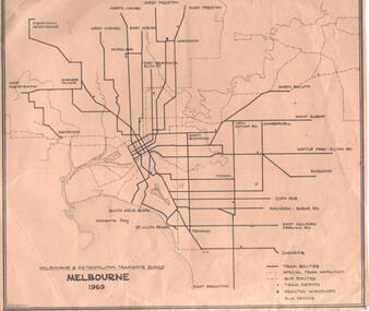
Map, Robert Green, "Melbourne 1969", 1969
Map - MMTB "Melbourne 1969" showing MMTB tram and bus routes and waterways, tram and bus depots and workshops printed on a light brown paper, prepared by R. W. Green (Robert) Shows the names of the various suburban termini.trams, tramways, map, tram routes, bus routes, depots -
 Federation University Historical Collection
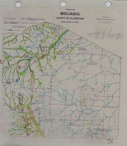
Map, Moliagul
printed map with hand colouringmoliagul, welcome stranger nugget -
 Eltham District Historical Society Inc
Negative - Photograph, Harry Gilham, Terrace Wall Section, Eltham Cemetery, Mount Pleasant Road, Eltham, 1 Aug 2007
Richard Gilsenan was a retired schoolteacher living at “Rosebank” in Eltham, now the site of the Living and Learning Centre. In 1906, Eltham Primary School’s headmaster John Brown died, and Richard was brought out of retirement (briefly) to be acting headmaster. His son Harold was a junior teacher there at the time. Thereafter, Richard was Secretary of the Eltham Progress League and more importantly was a magistrate at the Eltham Court of Petty Sessions. Cases commonly brought before him included not sending a child to school (typical fine 5/- or eight hours in the lock-up), not having a child vaccinated (fixed fine 40/-), stealing fruit from an orchard, selling liquor out of hours, and offensive language and behaviour. Other miscellaneous cases were allowing cattle to wander, selling cigarettes to a minor, carelessly burning off rubbish on a hot windy day, dumping a dead horse in the Diamond Creek, and youths throwing ripe fruit at passers-by. Richard died in 1920 and is buried in Eltham Cemetery with his wife Harriet Eliza. In mourning his passing, his peers noted that his decisions had been given in a very fair way. Incidentally, his son Harold (the teacher) died in 1921 after being trampled by a horse while en route from Eltham to Cathkin (his then school). In Loving Memory Of Richard Edward Gilsenan Died 30th July 1920 Aged 73 years Also Harriet Eliza Beloved wife of above Died 7th Sept. 1933 Aged 78 years Sweet Rest And In Loving Memory Of Barbara Ann Beloved wide of G. R. Gilsenan Died 18th Sept. 1917 Aged 38 years Also the above George Richard Gilsenan Died 2nd Nov. 1918 Aged 40 yearseltham cemetery, gravestones, memorials -
 Eltham District Historical Society Inc
Negative - Photograph, Art show, Eltham Community Centre, c.1994
An art auction for the Save the Copper Butterfly campaign arranged by Pauline Toner was held in 1987 at which a number of which were acquired by the Shire of Eltham for the Eltham Art Collection, now part of the Nillumbik Art Collection. This show circa 1994 in the Eltham Community Centre displayed several of the works.Roll of 35mm colour negative film, 1 stripKodak Gold 100-4art exhibition, eltham community centre, eltham copper butterfly, nillumbik art collection, adriane strampp -
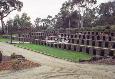
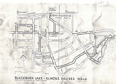 Whitehorse Historical Society Inc.
Map, Blackburn Lake - Elmore houses walk, 1/11/1991
Map of Blackburn outlining a walk through the lake.Map of Blackburn outlining a walk through the lake. The route includes four Elmore houses.Map of Blackburn outlining a walk through the lake.maps, blackburn lake sanctuary, the avenue, blackburn, laburnum street, main street, gardenia street, blackburn road, gordon crescent -
 Bendigo Historical Society Inc.
Map - Hustler's Line of Reefs
Longitudinal section of Hustler's Reef & Hustler's Reef no. 1 mine. Plate XX, note plates 4,8,13,20, 26 & 31 form a longitudinal section from Fortuna Hustler's to Hustler's Consols Mine. produced by the underground survey office, Bendigo, September 1913.hustler's reef, bendigo goldfields, hustler's reef no.1 mine -
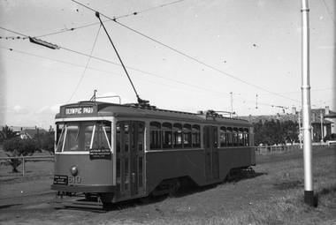 Melbourne Tram Museum
Negative, Wal Jack, mid 1950's
Black and white negative, by Wal Jack, Y1 610 of an AETA tour at Point Ormond, with destination of Olympic Park. Photo possibly mid 1950'strams, tramways, aeta tour, point ormond, y1 class, tram 610 -
 Bendigo Military Museum
Map - Australian Topographical Survey NAGAMBIE SW Sheet, 1 inch:1 Mile, NW portion Plane Table Field sheet 1921, Australian Survey Corps, 1921
This is a coloured reproduction print of an original Plane Table compilation map sheet of Nagambie area 1inch to 1 Mile scale compiled by Sgt Jack Cullen Australian Survey Corps 30 September 1921. Jack was one of the foundation members of the Australian Survey Corps. Of particular interest is the fact that this is a heighted compilation with contouring (required for Military use) as many early maps were purely planimetric. A table on the right hand side details the number of days that it took to produce the compilation. The reverse side of this print is a copy of the Tallarook plane table South East field sheet.Reprinted coloured Image of Australian Topographical Survey NAGAMBIE SW Sheet,1 inch:1 Mile, NW portion hand drawn Plane Table Field sheet. Includes an itemized summary of work, signed by Sgt J Cullen Australian Survey Corps September1921.royal australian survey corps, rasvy, fortuna, army survey regiment, army svy regt, asr -
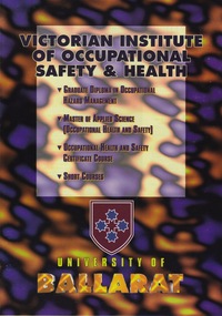 Federation University Historical Collection
Education kit - Education Kit - Brochure for VIOSH Courses, VIOSH: University of Ballarat; General Information, Research Activities, Course Outlines for Grad Dip in Occupational Hazard Management,Master of Applied Science (OH&S), Occupational Health and Safety Certificate Course, Short Courses. 1994
Victorian Institute of Occupational Safety and Health (VIOSH) Australia is the Asia-Pacific centre for teaching and research in occupational health and safety (OHS) and is known as one of Australia's leaders on the field. VIOSH has a global reputation for its innovative approach within the field of OHS management. VIOSH had its first intake of students in 1979. At that time the Institution was known as the Ballarat College of Advanced Education. In 1990 it became known as Ballarat University College, then in 1994 as University of Ballarat. It was 2014 that it became Federation University. VIOSH Australia students are safety managers, senior advisors and experienced OHS professionals. They come from all over Australia and industry. Students are taught active research and enquiry; rather than textbook learning and a one-size fits all approach. VIOSH accepts people into the Graduate Diploma of Occupational Hazard Management who have no undergraduate degree - on the basis of extensive work experience and knowledge. Coloured brochure advertising the VIOSH Courses at the University of Ballarat. Amendments to the information are marked in blue pen. The courses are outlined and information given on resources and research activities. There is an Open Day Sunday 28 August 1994. Application details are available from VIOSH, University of Ballarat.Coloured 4 pages - pp2, 3, 4, divided into three columnsSymbol of University of Ballarat. Date of Open Day - 28 August 1994viosh, victorian institute of occupational safety and health, university of ballarat, brochure, graduate diploma in occupational hazard management, open day, information resources, research activities, course applications, master of applied science (ohs), occupational health and safety certificate -
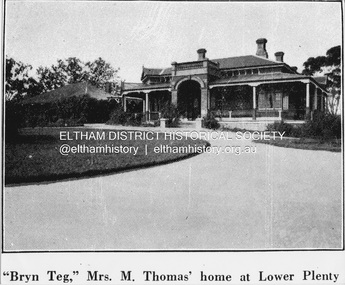 Eltham District Historical Society Inc
Negative - Photograph, Coghill & Haughton, 'Bryn Teg', Mrs M. Thomas' home at Lower Plenty, c.1924
Negative copy and associated print of detail from original Sales Brochure: Plenty Township Estate and Bryn Teg Hill's Estate, Coghill & Haughton, Melbourne (c.1924)Roll of 35mm Black and White negative film, 3 strips, (1 of 14 frames) Print 10 x 15 cmFilm - Agfa Ortho 25bryn teg hill's estate, coghill & haughton, sales brochure, lower plenty, bryn teg, houses, mrs m thomas, plenty township estate, real estate agent -
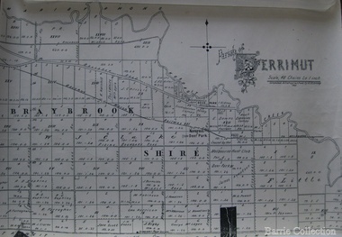 Melton City Libraries
Map, Parish of Derrimut, 1931
Map of the Parish of Derrimutcouncil -
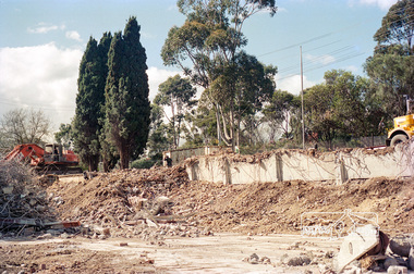 Eltham District Historical Society Inc
Negative - Photograph, Harry Gilham, Demolition of Eltham Shire Offices, 895 Main Road, Eltham, Aug. 1996
The Shire Offices opened in 1965 and were extended in 1971. The final Eltham Shire Council meeting was held in December 1994 before the forced amalgamations of municipal councils by the Kennett Government. The State-Government-appointed Commissioners (1994-1996) took the decision in July 1996 to demolish the Eltham Shire Offices. The demolition works started within 24 hours of the decision being made.Roll of 35mm colour negative film, 5 of 6 strips Associated colour printKodak Gold 100-5eltham shire office, demolition, shillinglaw trees -
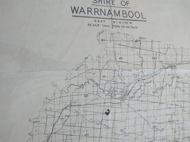 Peterborough History Group
Map - Shire of Warrnambool East Riding
Contextual location of Peterborough town within the shire at that time, including local roads.Historic informationA3 size map of the Warrnambool Shire East Riding, includes landscape details, and the location of town in the Shire.Irvine written in pencil on the backpeterborough, curdies river inlet, old maps, warrnambool shire map -
Stawell Historical Society Inc
Map, P Jones, Shire of Stawell Roads and Reserves, 1989
Shows Woodlands Forests & Open WoodlandTwo Copies (2) map With roads around Stawell. Forests Woodlands 2 Very open Woodlands Coloured.Drawn P Jones. May 1989. Last Amended 25 may 1989 -
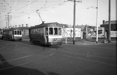 Melbourne Tram Museum
Negative, Wal Jack, 20/04/1945 12:00:00 AM
Black and white negative, by Wal Jack, of S155 and S 166 turning from Ballarat Road into Gordon St, while running a SPECIAL E or Explosives factory service. A third tram is directly behind 166. In the background on the corner block are bill boards advertising 3AW's Cashmere Bouquet products, Richmond Pilsner and a real estate board by W. R Morris for shops and dwellings. Also a waste paper collection basket. Photo dated 20-4-1945 in the Wal Jack album along with details of the location and the tramcar.trams, tramways, ballarat road, gordon st, footscray, world war 2, special e, s class, tram 155, tram 166 -
 Bendigo Military Museum
Map - Map Extract - Charterhouse of Mendip, John James Raisbeck, Unknown
Map extract showing the towns of Cheddar, Rodney Stoke, Westbury and a smaller town of Easton. The area depicted is part of Somerset, England. Map is hand drawn by J.J. Raisbeck date unknown. John James RAISBECK was born on 4 July 1880 at Christchurch New Zealand. He served 4 years (Citizen Military Force - CMF) in 9th Australian Light Horse Regiment in Central VIC with the rank 2nd Lieutenant. He was the first Australian appointed to the Survey Section RAE, on 16 April 1910, as a draughtsman which was his civilian profession, with the rank Warrant Officer, honorary 2nd Lieutenant. He was required to resign his commission in the CMF. He supervised the draughting work of the Section in Melbourne and was largely responsible for the mapping standards and specifications set in the production of the Cowes one-inch-to-one-mile military map, which became the enduring Australian standard. He was also responsible for supervising the printing of the maps by the Victorian Government Printer. He was appointed 2nd Lieutenant in the AIF Survey Corps draft on 6 December 1917 (from Melbourne) embarking for England on 22 December 17. He was attached to the Australian Corps Topographic Section in France from 21 April 1918 to 5 March 1919 serving as Second-in-Command and as Officer Commanding. He was promoted Lieutenant 15 October 1918, attending the AIF Survey School, Southampton in 1919, returning to Australia 23 June 1919, before his AIF appointment was terminated 17 July 1919. He went on to serve the Survey Section RAE and Australian Survey Corps, including in the Second World War, having been promoted Captain then Major and Officer Commanding Army Headquarters Cartographic Section until February 1940. He retired after 33 years of service to military survey, and after serving the Corps in two world wars, on 4 July 1943 with the retired rank Lieutenant-Colonel. He was the author of the article ‘A Short History of the Military Survey of Australia, 1907-1936’, published in The Australian Surveyor, Sept 1, 1937Map extract slightly larger than A4. Scale: One Inch to One and a half Mile. 1:31680, 9 x copiesSignature of "J.J. Raisbeck" bottom right-hand cornerroyal australian survey corps, rasvy, fortuna, army survey regiment, army svy regt, asr