-
 Port Melbourne Historical & Preservation Society
Plan - Ada Mary A'Beckett Free Kindergarten, Fishermans Bend, Martin & Tribe, Architects, 21 Mar 1949
Martin & Tribe - ArchitectsPlans, Ada Mary A'Beckett Free Kindergarten - final details i.e. kerbing, tanbark, flagpole. 1947.education - kindergartens, garden city, built environment - civic, fishermans bend, ada mary a'beckett, martin & tribe, ada mary a'beckett kindergarten -
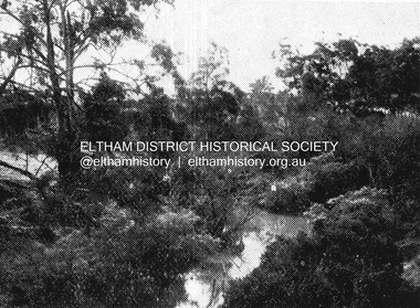 Eltham District Historical Society Inc
Negative - Photograph, Coghill & Haughton, Plenty River at Lower Plenty, c.1924
Negative copy and associated print of detail from original Sales Brochure: Plenty Township Estate and Bryn Teg Hill's Estate, Coghill & Haughton, Melbourne (c.1924)Roll of 35mm Black and White negative film, 3 strips, (1 of 14 frames) Print 10 x 15 cmFilm - Agfa Ortho 25bryn teg hill's estate, coghill & haughton, sales brochure, lower plenty, plenty river -
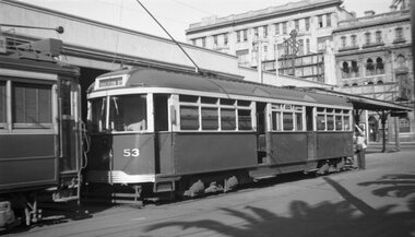 Melbourne Tram Museum
Negative, Wal Jack, c1951
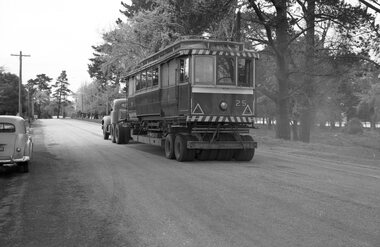
Set of two Black and white negatives of VR 53 at the St Kilda Railway Station. The first image has the conductor tying down the pole rope. The tram has the destination of Brighton Bch. In the background are the Railway Station verandah and The George Hotel.trams, tramways, brighton beach, vr trams, st kilda brighton, st kilda railway station, tram 53 -
 Kew Historical Society Inc
Plan, Melbourne & Metropolitan Board of Works : Borough of Kew : Detail Plan No.1571, 1904
The Melbourne and Metropolitan Board of Works (MMBW) plans were produced from the 1890s to the 1950s. They were crucial to the design and development of Melbourne's sewerage and drainage system. The plans, at a scale of 40 feet to 1 inch (1:480), provide a detailed historical record of Melbourne streetscapes and environmental features. Each plan covers one or two street blocks (roughly six streets), showing details of buildings, including garden layouts and ownership boundaries, and features such as laneways, drains, bridges, parks, municipal boundaries and other prominent landmarks as they existed at the time each plan was produced. (Source: State Library of Victoria)This plan forms part of a large group of MMBW plans and maps that was donated to the Society by the Mr Poulter, City Engineer of the City of Kew in 1989. Within this collection, thirty-five hand-coloured plans, backed with linen, are of statewide significance as they include annotations that provide details of construction materials used in buildings in the first decade of the 20th century as well as additional information about land ownership and usage. The copies in the Public Record Office Victoria and the State Library of Victoria are monochrome versions which do not denote building materials so that the maps in this collection are invaluable and unique tools for researchers and heritage consultants. A number of the plans are not held in the collection of the State Library of Victoria so they have the additional attribute of rarity.Digital copy of the original survey plan, issued by the MMBW to a contractor with responsibility for constructing sewers in the area identified on the plan within the Borough of Kew. The plan was at some stage hand-coloured, possibly by the contractor, but more likely by officers working in the Engineering Department of the Borough and later Town, then City of Kew. The hand-coloured sections of buildings on the plan were used to denote masonry or brick constructions (pink), weatherboard constructions (yellow), and public buildings (grey). This plan is part of a large and historically significant group of MMBW plans and maps that was donated to the Society by the Mr Poulter, City Engineer of the City of Kew in 1989. When the contracts were let for surveyors to identify and record the extant houses and landscapes within an area for the Board of Works, the contracts were let at separate times, hence the anomaly where two copies of Plan No.1571 exist in our collection. The first of these plans identifies the building materials used in houses bordering Fitzwilliam Street, Edgevale Road, May Street, Malin Street, Davis Street and Wellington Street. The cut off point for the survey was the south side of Wellington Street. By 1903 when the survey was undertaken many of the sites were already built on, particularly those facing Edgevale Road. The plan identifies the preponderance of weatherboard houses in the area. The other version of the plan identifies the buildings between Wellington Street and Cotham Road.melbourne and metropolitan board of works, detail plans, mmbw 1571, cartography -
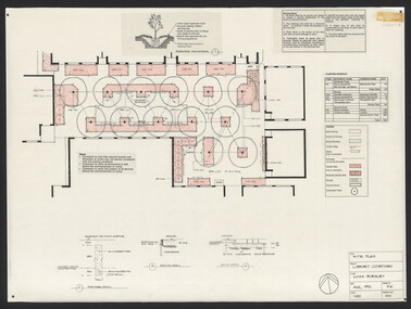 University of Melbourne, Burnley Campus Archives
Plan, Steve Mullany, Classroom Quadrangle/Library Courtyard, 1985-1999
Various plans. (1) Photocopy of Section A-A, 1985 and 1 photocopy of part of plan. (2) Tracing paper copy, Construction Plan Classroom/Library Quadrangle Feb. 1986. (3) Master Plan, coloured and detailed and 1 copy not detailed, Classroom Quadrangle Landscape Redevelopment by S. Mullany, 10 August 1988. (4) 4 tracing paper and 2 paper copies Set of Plans Library Courtyard Aug 1992 by KW. (5) Miscellaneous sketches. (6) Assessment task. (7) Sketch Proposal Quad Entry by M. Green May 1995. (8) Quadrangle Steps Redevelopment 7/12/99 by Phil Tulk. (9) Tracing paper and paper copies Quadrangle Steps Redevelopment by JK 20.12.99.classroom, library, courtyard, steve mullany -
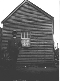 Wodonga & District Historical Society Inc
Negative - Haeusler Glass Negatives Collection - Man with straw boater hat, c1910
The Wodonga Historical Society Haeusler Collection provides invaluable insight into life in late nineteenth and early twentieth century north east Victoria. The collection comprises manuscripts, personal artefacts used by the Haeusler family on their farm in Wodonga, and a set of glass negatives which offer a unique visual snapshot of the domestic and social lives of the Haeusler family and local Wodonga community. The Haeusler family migrated from Prussia (Germany) to South Australia in the 1840s and 1850s, before purchasing 100 acres of Crown Land made available under the Victorian Lands Act 1862 (also known as ‘Duffy’s Land Act’) in 1866 in what is now Wodonga West. The Haeusler family were one of several German families to migrate from South Australia to Wodonga in the 1860s. This digital image was produced from one of the glass negatives that form part of the collection, probably taken by Louis Haeusler (b.1887) with the photographic equipment in the Wodonga Historical Society Haeusler Collection. This item is unique and has well documented provenance and a known owner. It forms part of a significant and representative historical collection which reflects the local history of Wodonga. It contributes to our understanding of domestic and family life in early twentieth century Wodonga, as well as providing interpretative capacity for themes including local history and social history.Digital image created from the Haeusler Glass negative collection. An image of a smartly dressed man wearing a straw boater hat. C. 1910wodonga pioneers, haeusler family, glass negatives, dry plate photography -
University of Melbourne, Burnley Campus Archives
Plan, Overall Plans VACH
nursery, site plan, field station -
 University of Melbourne, Burnley Campus Archives
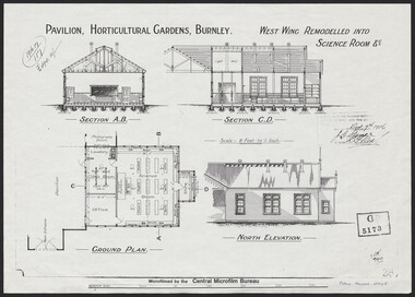
Plan, Pavilion, Horticultural Gardens, Burnley, 1916
1 large and 2 identical smaller photocopies. Pavilion, Horticultural Gardens, Burnley. Elevations and Ground Plan of "West Wing Remodelled into Science Room." Stamp GB 5173. Stamp date Dec 7th 1916. From Public Records Office.pavilion, burnley gardens, burnley school of horticulture -
 Federation University Historical Collection
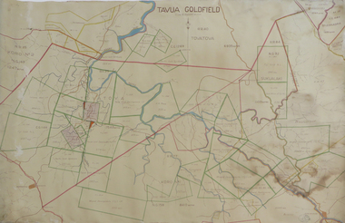
Plan, Tavua Goldfield, 1935
Printed plan with coloured shading of Tavua Goldfield tavua goldfield, tavua, lands department fiji -
University of Melbourne, Burnley Campus Archives
Plan - Photocopy, Burnley College, 1980
Copied by Emma Ferguson and Jo van Berkel for their Oct 1994 ThesisPhotocopy of plan of Burnley College naming the majority of buildings, including Administration Building, residence, silo bins, store, manure bins, milking shed, P lant Research Lab., breeder pens, Gardensburnley college, pavilion, emma ferguson, jo van berkel -
 Eltham District Historical Society Inc
Negative - Photograph, Silvan Gully area, Upper Diamond Creek, c.1911
Silvan Gully area showing the cleared line for railway construction. The railway was extended from Eltham to Hurstbridge in 1912.Roll of 35mm colour negative film, 4 stripsKodak Safety 5035upper diamond creek, silvan gully, wattle glen, railway construction -
Moorabbin Air Museum
Plan (item) - Bristol Aeroplane 170 schematic drawings, Access Door- Top Skin- Rear Front Spar
Bristol Aeroplane Company Ltd -
Port Melbourne Historical & Preservation Society
Plan - Façade, Port Melbourne Town Hall, Port Melbourne City Council, 1916
Plan - Details of building front of 1915 Port Melbourne Town Hall.port melbourne town hall -
 Eltham District Historical Society Inc
Negative - Photograph, J.A. McDonald, Heidelberg-Kinglake Road, 3 Nov. 1959
Job 56M431 Contractors Wolf and Wood Yow Yow Creek Bridge Curve improvement north of bridge site 3 November 1959Record of various Shire of Eltham infrastructure works undertaken during the period of 1952-1962 involving bridge and road reconstruction projects, sometimes with Eltham Shire Council Project Reference numbers quoted. It was during this period that a number of significant improvements were made to roads and new bridges constructed within the shire that remain in place as of present day (2022). In many situations, the photos provide a tangible visible record of infrastructure that existed throughout the early days of the Shire. The album was put together by or under the direction of the Shire Engineer, J.A. McDonald.infrastructure, shire of eltham, bridge construction, heidelberg-kinglake road, road construction, yow yow creek, 1959-11-03 -
 University of Melbourne, Burnley Campus Archives
Negative - Colour prints and negatives, Burnley Landscapes and Dookie From Mt Major, 1990
26 views of the drive and garden near Plant Research Laboratory, Hilda Kirkhope Rockery and Luffmann Ponds. Many very similar. Labelled "Burnley landscapes Nov 1990." "Views of Dookie from Mt. Major." Some scanned.garden views, plant research laboratory, luffmann ponds, dookie, mt. major, hilda kirkhope rockery -
Moorabbin Air Museum
Plan (item) - Bristol Aeroplane 170 schematic drawings, Pneumatic System Diagram
Bristol Aeroplane Corporation Ltd -
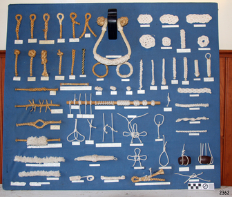 Flagstaff Hill Maritime Museum and Village
Education kit - Display Board of Knots, Tom Long, DSM (Member of International Guild of Knot Tyers), Before Sept 1986
The Display Board of Konts was handmade in Kings Lynn, Devon, England, by Tom Long DSM, who is a member of the International Guild of Knot Tyers. This display board shows the knots and joins used in ropework performed by a sailmaker and other skilled ropeworkers. It demonstrates the uses of some of the knots, such as for knobs and handles, suspending lengths of wood, reinforcing spliced rope and even for decorative work. The sailmakers travelling as part of the ship’s crew stored their tool kit in a canvas ditty bag. It contained needles, awls, a sailmaker’s leather palmed glove with a heavily reinforced palm - a shuttle to mend and make nets, fids, knives, mallets, brushes, rulers, and rope gauges. Sailmakers used their ropework and knot-making skills for various purposes and chose the type of rope fibre for its particular properties. For example, Italian hemp rope was preferred for the light line used in shore-to-ship rescues because it was lightweight, not easily knotted, and absorbed less water. A supply of various types of rope was a commodity on board a ship and on land in the new colonies. It was flexible, easily stored, and could be worked to create an endless variety of objects on its own or with other materials like wood. An example is a simple rope ladder. Lengths could be combined to make various thicknesses and pieces could be skilfully joined together by splicing. The importance of knots in seafaring cannot be overestimated. When ships relied on only the wind for power and speed, there were a huge number of various ropes in use, particularly with regard to the sails and rigging. Seafarers would be judged on their ability to tie knots speedily and correctly. A mounted display of authentic seaman's knots is on a board covered in blue fabric. Various rope grades and fibres were used to work numerous knots and splices. Some of the uses are familiar, such as the toggle, the pineapple knot, and the Turk’s head. A selection of rope grades and fibres were used to work numerous knots and splices. Some of the uses are familiar, such as the toggle, the pineapple knot, and the Turk’s head. The name or purpose of the knot is on the label below it. Labels below each knot give its name or use.flagstaff hill, warrnambool, maritime museum, maritime village, great ocean road, shipwreck coast, knot display, knot making, ropework, marine technology, sailmaker's work, sailor's knots, ship's rigging, seamen's knots, handmade, rope craft, knots, splices -
 Eltham District Historical Society Inc
Negative - Photograph, J.A. McDonald, Fordhams Road, Eltham, 24 July 1962
Culvert discharging towards land owned by Holloway & Spicer about 3pm on 24 July 1962 Heavy rainRecord of various Shire of Eltham infrastructure works undertaken during the period of 1952-1962 involving bridge and road reconstruction projects, sometimes with Eltham Shire Council Project Reference numbers quoted. It was during this period that a number of significant improvements were made to roads and new bridges constructed within the shire that remain in place as of present day (2022). In many situations, the photos provide a tangible visible record of infrastructure that existed throughout the early days of the Shire. The album was put together by or under the direction of the Shire Engineer, J.A. McDonald.1962-07-24, culvert, eltham, fordhams road, infrastructure, shire of eltham -
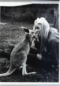 Robin Boyd Foundation
Negative
Possibly Suzy Boyd with a kangaroo.Black and white negative -
Glenelg Shire Council Cultural Collection
Plan - Ship Plan / Mould, n.d
Wooden pattern for mould for boat fitting. Two similar rectangular pieces joined in parallel by two small, similar rectangular pieces, at right angles to the larger rectangles, creating an open box-like shape. Painted white. -
 Eltham District Historical Society Inc
Negative - Photograph, Hohne's Hill, Homestead Road, Eltham Lower Park, c.Mar. 1983
Roll of 35mm colour negative film, 4 stripsKodak Safety 5035eltham lower park, hohnes reserve, homestead road -
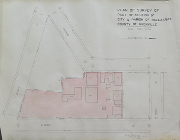 Federation University Historical Collection
Plan, Plan of Survey of Part of Section 9A City & Parish of Ballarat County of Grenville (Albert Street frontage), 1932
The M.B. John Trade Building was built on the Albert Street Frontage..1) Plan of SMB showing Albert, Grant, Lydiard and Dana streets, on paper with colored highlights undertaken by Ballarat School of Mines student George Murrowood in 1932 .2) Hand written page by George Murrowood, of technical description of land surveying Grade II 1932ballarat school of mines, surveying, george murrowood, albert street, alumni, m.b. john building, architectural plan -
Bendigo Historical Society Inc.
Negative - CASTLEMAINE GAS COMPANY COLLECTION: NEGATIVES
8 strips of negatives The negatives were inside envelope 11518.500 and photos from 11518.482 to 11518.498. These negatives have not been scanned.negative, bendigo, gas and fuel -
 Bendigo Historical Society Inc.
Negative - Bendigo Munitions Factory (ADI) Glass Slides, Australian Defence Industries (Now THALES AUSTRALIA), c1944
The Bendigo Ordnance Factory began operating in 1942, producing heavy artillery and naval guns. In the late 1990s the then Federal Government-owned facility was sold to the multinational Thales, which continues to operate the factory today. This Bendigo Historical Society collection of glass negatives includes some slides of women working in the munitions factory. Seven slides were included in an album that was prepared for Dr Edith Summerskill who visited Australia in 1944 as part of an Empire Parliamentary Delegation. The album included photographs of Australian women working at the factory during WW2. A copy of the album is in the Collection of the Australian War Memorial.Box 1 of 3, Glass Slide Negatives of the Bendigo Munitions Factory, later known as the Ordnance Factory and then the Australian Defence Industries. Each negative is sealed between two pieces of glass. The edges are sealed with thin pieces of tape. The slides are contained in three wooden boxes with hinged lids and grooves (slots) to house them.history, bendigo, bendigo munitions factory, bendigo ordnance, bendigo adi, doctor edith summerskill, ww2, slide box 1 10165, slide box 2 10166, slide box 3 10167 -
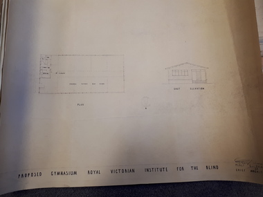 Vision Australia
Plan - Image, Proposed Gymnasium Royal Victorian Institute for the Blind, 21 June 1950
In 1951 plans were made for the construction of a gymnasium to be situated in the grounds of St Kilda Road. These 4 plans specify the building construction notes, present front and east elevations, and show how part of the hall could be transformed into bedrooms in the future. There are 2 copies of each plan, consisting of identifical copies of the east elevation and different notes printed/handwritten on the front, side and top elevations. These were presented to the RVIB Board in Feburary 1951, according to the stamp on the back.2 architectural plans showing proposed gymnasium buildingPercy E Everett Chief Architectroyal victorian institute for the blind, plans -
 Ballarat Tramway Museum
Negative, Wal Jack, 6/10/1960 12:00:00 AM
Yields information about Ballarat tram No. 25 departing for Bendigo in Wendouree Parade.Negative and Digital images of the Wal Jack Ballarat Negative file of No 25 loaded on a Yellow Express truck leaving for Bendigo in Wendouree Parade. See Reg Items 1478, 5241, 5242, 7759 and 7766 for a series of 5 photos of this event. trams, tramways, yellow express, transporting trams, moving trams, bendigo, tram 25 -
 Wodonga & District Historical Society Inc
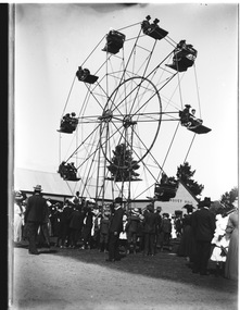
Negative - Haeusler Glass Negatives Collection - Ferris Wheel, c1910
The Wodonga Historical Society Haeusler Collection provides invaluable insight into life in late nineteenth and early twentieth century north east Victoria. The collection comprises manuscripts, personal artefacts used by the Haeusler family on their farm in Wodonga, and a set of glass negatives which offer a unique visual snapshot of the domestic and social lives of the Haeusler family and local Wodonga community. The Haeusler family migrated from Prussia (Germany) to South Australia in the 1840s and 1850s, before purchasing 100 acres of Crown Land made available under the Victorian Lands Act 1862 (also known as ‘Duffy’s Land Act’) in 1866 in what is now Wodonga West. The Haeusler family were one of several German families to migrate from South Australia to Wodonga in the 1860s. This digital image was produced from one of the glass negatives that form part of the collection, probably taken by Louis Haeusler (b.1887) with the photographic equipment in the Wodonga Historical Society Haeusler Collection.This item is unique and has well documented provenance and a known owner. It forms part of a significant and representative historical collection which reflects the local history of Wodonga. It contributes to our understanding of domestic and family life in early twentieth century Wodonga, as well as providing interpretative capacity for themes including local history and social history.Digital image created from the Haeusler Glass negative collection. A large group of people gathered in front of a Ferris wheel. Building labelled "Banquet Hall" is in the background. The location is not confirmed. C. 1910"Banquet Hall" on the building in the background.wodonga pioneers, haeusler family, glass negatives, dry plate photography, ferris wheel -
 Melbourne Legacy
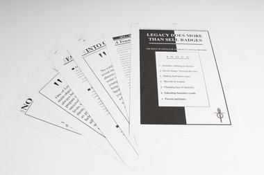
Education kit, Legacy does more than sell badges: The role of Legacy in Australia's social History. An Australian history resource for use with Secondary Students, 1992, 1993
Education kit produced by Sydney Legacy in 1992 and distributed to Victorian schools by Melbourne Legacy in August 1993. Contains the following: 00058.1 folder 00058.2 covering letter from the Director of School Education Victoria commending the kit to school principals. 00058.3 Index 00058.4 1914 - 1918 "The war to end all wars" (Card 1) 00058.5 Settling into civilian life (Card 2) 00058.6 Making hard times easier (Card 3) 00058.7 Women in war (Card 4) 00058.8 Changing face of Australa (Card 5) 00058.9 Australia's Youth (Card 6) 00058.10 Legacy now & forever (Card 7)Significant as an example of resources produced by Legacy to educate secondary school students about Legacy's history, work and significance in Australian history.Paper card folder with 8 double-sided paper inserts and a covering letter from the Director of Schools Education. Two copies.history, activities -
 Eltham District Historical Society Inc
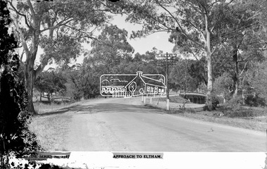
Negative - Photograph postcard, The Rose Stereograph Company, Approach To Eltham, c.1939
Looking east along the unsealed main road heading into Eltham across the concrete bridge over the Diamond Creek circa 1939. The original wooden bridge was destroyed by flood waters in 1924. This glass plate negative was used to manufacture postcards (1:1 printing) for commercial sale by the Rose Sterograph Company and its subsidiaries. George Rose founded the Rose Stereograph Company in 1880 and was joined by Herbert (Bert) Cutts in the early 20th Century. The pair formed a lifetime working partnership and strong personal friendship. Assisted by George’s two sons, Herbert George and Walter, and later by Neil Cutts, the Rose Stereograph Company continued its operations for more than 140 years. The company was initially built on stereographs, but as cinema took over and stereographs fell out of fashion, the Rose Stereograph Company developed Australia’s first commercially viable photographic postcard business. Specialising in postcards of iconic historical moments and significant landmarks, The Rose Stereograph Company became a staple of the Australian travel industry.This remarkable collection of glass plate negatives, transparencies, and postcards – arguably Australia’s most significant photography collection outside of public hands – has been passed down through the generations, surviving war, relocation, and the harsh Victorian climate. The historic Rose Stereograph collection is the culmination of George Rose’s dream of capturing and preserving precious moments in time and remains the legacy of the Rose and Cutts families. It is with great sadness that the Cutts family says goodbye to a collection that spans five generations and 140 years. The Cutts family understands that for these historically important pieces to rest with one family is to deny others the pleasure of their custodianship.Glass Plate Negative Size: 9 x 14 cmApproach to Eltham, Valentine Series No. 3197, Copyrightbuildings, electricity lines, eltham, postcard, travel, rose stereograph company, valentine series postcard, main road bridge, glass plate negative, main road, peter and elizabeth pidgeon collection, diamond creek (creek), eltham south, rose stereograph -
 Kew Historical Society Inc
Plan - Subdivision Plan, Plan of Subdivision of Part of Crown Portion 84 / Parish of Boroondara / County of Bourke / Lodged Plan No. 2217, Twentieth Century
Pru Sanderson, in her groundbreaking ‘City of Kew Urban Conservation Study : Volume 2 - Development History’ (1988), summarised the periods of urban development and subdivisions of land in Kew. The periods that she identified included 1845-1880, 1880-1893, 1893-1921, 1921-1933, 1933-1943, and Post-War Development. These periods were selected as they represented periods of rapid growth or decline in urban development. An obvious starting point for Sanderson’s groupings involved population growth and the associated economic cycles. These cycles also highlighted urban expansion onto land that was predominantly rural, although in other cases it represented the decline and breakup of large estates. A number of the plans in the Kew Historical Society’s collection can also be found in other collections, such as those of the State Library of Victoria and the Boroondara Library Service. A number are however unique to the collection.The Kew Historical Society collection includes almost 100 subdivision plans pertaining to suburbs of the City of Melbourne. Most of these are of Kew, Kew East or Studley Park, although a smaller number are plans of Camberwell, Deepdene, Balwyn and Hawthorn. It is believed that the majority of the plans were gifted to the Society by persons connected with the real estate firm - J. R. Mathers and McMillan, 136 Cotham Road, Kew. The Plans in the collection are rarely in pristine form, being working plans on which the agent would write notes and record lots sold and the prices of these. The subdivision plans are historically significant examples of the growth of urban Melbourne from the beginning of the 20th Century up until the 1980s. A number of the plans are double-sided and often include a photograph on the reverse. A number of the latter are by noted photographers such as J.E. Barnes.Undated Plan of Subdivision of Crown Portion 84 in what is now Kew. The area shown is bordered by Burke Road, Harp Road, Arglye Road and Normanby Road.subdivision plans -- kew (vic), harp road, burke road, normanby road, lady loch's drive, gladstone street, second avenue, first avenue