-
 Eltham District Historical Society Inc
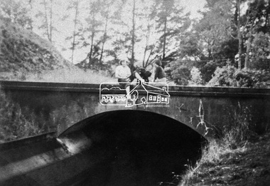
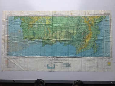
Negative - Photograph, Maroondah Aqueduct, 1991
Roll of 35mm colour negative film, 9 strips Colour print 10 x 15 cmFuji HG 200 CA-1maroondah aqueduct -
 Eltham District Historical Society Inc
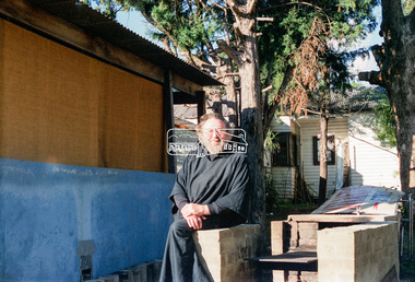
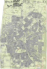
Negative - Photograph, Eltham Shire Council, Possibly a non-compliant house in Simms Road, Kinglake, c.1989
Facebook comments suggested this location may be a cabinetmaker by the name of Cook out the back of Panton Hill. Another comment recalled this man as a visitor to Montsalvat as a friend of the late poet, Geoffrey Egglestone. It is believed his name is Mizza. He is a Bohemium Poet. Also a frequent visitor to the St Andrews market. Photos taken by Eltham Shire Council officers most likely during an inspection of the property for non compliance. Other images on the roll of film are of Council Health officers undergoing food inspections at the shops, maternal health services and housing estate development inspectionsRoll of 35mm colour negative film, 6 strips Frames 3 through 9Fuji 100eltham shire council, shire of eltham, 1989, atlantic ethyl, sheds, signs, unidentified, houses, kinglake, simms road -
 Kew Historical Society Inc
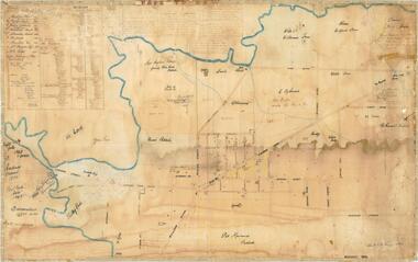
Map - Back to Kew 1875, Jesse Dannock, c.1931
The Kew Historical Society has an extensive collection of maps and plans; most relating to the former City of Kew (1860-1994). Within this collection, this hand-drawn map is unique.The most important and earliest original map of Kew in the collection, showing places of interest in early Kew.Hand-coloured map on heavy paper, depicting from Kew in 1875 from memory by Jesse Dannock. The map includes the names of local institutions and old residents. These, and many of the street names are very faded and have been overwritten with biro at a later date.maps - kew (vic), mrs dannock's map, cartography -
 Stawell Historical Society Inc
Map - Drawings, Wendy Jacobs, Wester Highway Community Precinct Development Hydrolic Services, 2014
Used in Building Historical Society BuildingTwo (2) A1 Printed Plans Hydrolic ServicesDrawing No. H100 Rev C1 July 2014. Drawing No. H101 Rev C1 July 2014 -
Glenelg Shire Council Cultural Collection
Negative - Glass Plate Negative - Bush Scene, 1890-1910
Glass plate negative. Image is of a bush scene, river running through centre of negative. Horse standing on bank of river. -
 Eltham District Historical Society Inc
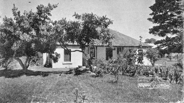
Negative - Photograph, Home Beautiful (United Press), Thomas Sweeney's original cottage at Culla Hill, Eltham, 1940
Feature article in Home Beautiful magazine (c.1940) on the original Sweeney's Cottage at Culla Hill built by Thomas Sweeney, one of the district's pioneer settlersRoll of 35mm black and white negative film, 3 stripsKodak Safety 5062culla hill, eltham, home beautiful magazine, houses, sweeney's cottage, sweeneys lane, thomas sweeney -
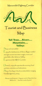 Marysville & District Historical Society
Map (Item) - Tourist and business map, Narbethong Community and Tourism Group, Narbethong Buxton Taggerty Tourist and Business Map, 04-2008
A tourist and business map of Narbethong, Buxton and Taggerty. This map was produced by the Narbethong Community and Tourism Group in April 2008. It was produced to promote the natural attractions, adventure activities and food trail from the Black Spur, through Narbethong, Buxton and Taggerty.A tourist and business map of Narbethong, Buxton and Taggerty.This publication has been produced by the Narbethong Community and Tourism/ Group (NCTG) to promote the natural attractions, adventure activities and food/ trail from the Black Spur, through Narbethong, Buxton and Taggerty./ the information provided in this publication has been supplied by the individual/ members. NCTG takes no responsibility for its accuracy./ April 2008narbethong, buxton, taggerty, victoria, australia, tourist and business map, narbethong community and tourism group, acheron valley, yarra track, wood's point, black spur, mystic mountains, the meeting of the waters, cathedral range, danico design counted cross stitch, things of sand & stone, buxton zoo nursery & oddz & enz, willowbank at taggerty, safe trek 4wd services, pnl 4wdriving, buxton trout and salmon farm, mystic mountains ski hire & outdoors, narbethong ski hire, highwood health centre, cathedral view natural therapies, narby cabinets, plants by shelian, gb timber, executive signs, rb automotive repairs, buxton car care, marysville towing & equipment hire, martyn slade building design, cathedral peak framing, black spur roadhouse & ski hire, tudor lodge roadhouse & ski hire, buxton roadhouse & persian bazzar, buxton post office general store & niche bar, igloo roadhouse, taggerty store, narby eggs, marapana agistment park, mantirri blueberry farm, carmyle farm, hazelwood hazelnuts, south cathedral lavender farm, cathedral cherries, black spur motel & caravan park, woodlands rainforest retreat, chestnut glade, black spur inn, wombat cottage, abbey lake luxury b & b spa cottages, blue views holiday cottages, camp narbethong, marapana farm stay b & b, mantirri blueberry farm b & b, little dene garden cottages, silverstream b & b cottages, nareen cabins, moondai farm b & b, south cathedral farm luxury b & b cottages, yarrolyn caravan park, sarsens rest, lomah retreat, pinjarra gardens, kingbilli country estate, henry viii manor house, buxton hotel, butters cafe of buxton, wagtail wines, little river wines, lanterns at willowbank, wirrawilla rainforest walk, wilhemina falls, the cascades -
Whitehorse Historical Society Inc.
Map, Boronia Road, Vermont, 1970
Enlargement of aerial photograph of Boronia Road, Vermont. State Aerial Survey 1970 Run 37Enlargement of aerial photograph of Boronia Road, Vermont. State Aerial Survey 1970 Run 37Enlargement of aerial photograph of Boronia Road, Vermont. State Aerial Survey 1970 Run 37boronia road, vermont, lusk drive, vermont, morack road, vermont south, allison court, vermont, trinian street, vermont, cosgrove street, vermont, mawson court, vermont, aerial photographs -
 Vision Australia
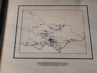
Map - Object, Victorian railways map
A black and white map of Victoria showing the railway lines where mail is transported and the individual towns listed next to the dot that provides location of such. Underneath is written "Map of Victoria showing the localities beyond the suburbs of Melbourne to which library books are sent to blind members. Books are carried over the railways FREE there is no charge to the readers." Through the work of Tilly Aston, braille postage was provided free by the Victorian Railways which greatly assisted the Braille Library in reaching members who resided outside of Melbourne. This map was produced to show the extent of the work by the Victorian Association of Braille Writers and the need for reading materials across the state.Paper of Victorian railway lines mounted in framevictorian association of braille writers, marketing -
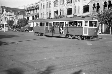
 Ballarat Tramway Museum
Negative - Black and white print from negative, Travis Jeffrey, 11/06/1960 12:00:00 AM
Negative No. N385 and black and white print made by a laser printer (stored in folder) of Ballarat No. 34 in bound from the Gardens, in Sturt St. West, approaching the "School Children Only" tram stop. Tram has destination of Mt. Pleasant and a front dash canopy advertisement for the Ballarat Civic Hall Dances and an SEC roof advertisement. Date of photo on folder - 11/6/1960. Original negative rescanned 24/5/2020 and image file updated. Paper folder that contained the negative had "NR33A" in red ink, "BA13" in pencil, date stamp of "11 June 1960" on front, and on rear date stamps "26 Sep 1962" and "6 Oct 1962".trams, tramways, sturt st west, tram stops, schools, tram 34 -
 Wodonga & District Historical Society Inc
Negative - Haeusler Glass Negatives Collection - Ferdinand Haeusler, Maria Klinge, Gottlieb Haeusler, Anna Werner nee Klinge and August Klinge, c1910
The Wodonga Historical Society Haeusler Collection provides invaluable insight into life in late nineteenth and early twentieth century north east Victoria. The collection comprises manuscripts, personal artefacts used by the Haeusler family on their farm in Wodonga, and a set of glass negatives which offer a unique visual snapshot of the domestic and social lives of the Haeusler family and local Wodonga community. The Haeusler family embarked on the “Pauline” from Bremen, Germany in 1846. They lived in South Australia before migrating to the Wodonga West area in Victoria in 1866. Shipping records show the family who left Germany together consisted of William and his wife Johanna Eleanore Klinge nee Schultz and their children Ferdinand, Louise and Gottlieb as well as Johanna Eleanore’s children from her first marriage - Johann Wilhelm Klinge, Johanne Caroline Klinge and Johann August Klinge. Other members of the Haeusler family migrated to South Australia at a later date, settling in South Australia, Victoria and New South Wales. This digital image was produced from one of the glass negatives that form part of the collection, probably taken by Louis Haeusler (b.1887) with the photographic equipment in the Wodonga Historical Society Haeusler Collection.This item is unique and has well documented provenance and a known owner. It forms part of a significant and representative historical collection which reflects the local history of Wodonga. It contributes to our understanding of domestic and family life in early twentieth century Wodonga, as well as providing interpretative capacity for themes including local history and social history.Digital image created from the Haeusler Glass negative collection. A family photo of Ferdinand Haeusler, Maria Klinge, Gottlieb Haeusler, Anna Werner nee Klinge and August Klinge. House in the background would have belonged to either Ferdinand or Gottlieb Haeusler.wodonga pioneers, haeusler family, glass negatives, dry plate photography, klinge family -
 B-24 Liberator Memorial Restoration Australia Inc
Map - US World War II multi-coloured map, Side 1 - No. C-47 South Borneo, Side 2 - No. C-48 West Java, 1944
Silk and rayon maps were produced by the United States (c. 7.5 million in total), Great Britain (some 1.75 million in total) and Australia during World War II. They were issued to Allied military personnel as part of 'escape and evasion' kits.This map, printed on acetate rayon, is an original US 'escape and evasion' kit map from World War II.A multi-coloured, contoured, double-sided map printed on acetate rayon AAF Cloth Chart Side 1 - No. C-47 South Borneo Side 2 - No. C.48 West Javaunited states of america, silk and rayon maps, world war ii, a191 -
Stawell Historical Society Inc
Map, Parish of Stawell, North Ward & Big Hill etc
Shows Newington Co, Moonlight Co, St George Co, Victoria Co, Galatea Co Shows Tramline over Big Hill, Leviathan Co, Parish of Stawell, North Ward & Big Hill etcstawell -
Ringwood and District Historical Society
Legal record - Conditions of Sale (C.E.Carter), Ringwood , Lot 100 on Plan of Subdivision 8022, Mr A.J.Loughnan & Mr J.A.O'Keefe To Mr C.E.Carter, 1947
Particulars and Conditions of Sale of Property , from Mr A.J.Loughnan & Mr J.A.O'Keefe to Mr C.E.Carter, Register No 8022. -
 Melbourne Tram Museum
Negative, Wal Jack, c1940
Black and white negative by Wal Jack of W4 670 (Moreland) east bound in Fitzroy St St Kilda, crossing the VR tram tracks at St Kilda Station. In the background is The George Hotel and other buildings. Photo undated, c1940.trams, tramways, fitzroy st, st kilda, moreland, w4 class, tram 670 -
 Ringwood and District Historical Society
Map, Old Creeks of Ringwood
A0-size (approx) City Engineer's map with hand-drawn overlay highlighting natural water-courses in the Ringwood area, as identified by Rob Atkins, former RDHS President. Other pencilled markings include Perry's Hut, Jull's Store, Crawley's Hut.Scale: 8 chains to 1 inch. -
Greensborough Historical Society
Map, Victoria: Yan Yean, prep. by Australian Section of Imperial General Staff, 1935
Part of 1:63,360 series of survey mapsColour copy from original. Scale: 1: 63,360 (1 inch to 1 mile) 2 copiesRev. 1930 by Australian Survey Corps using RAAF Air Photos. yan yean -
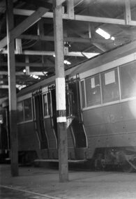 Ballarat Tramway Museum
Negative, Wal Jack, mid to late 1950's
Yields information about the tram 41 in the depot.Negative and Digital image of the Wal Jack Ballarat Negative file of No. No. 42 in the depot. Shows the depot structure.trams, tramways, depot, tram 42 -
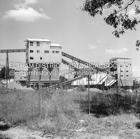 Eltham District Historical Society Inc
Negative - Photograph, J.A. McDonald, Unidentified quarry, Jan. 1961
Record of various Shire of Eltham infrastructure works undertaken during the period of 1952-1962 involving bridge and road reconstruction projects, sometimes with Eltham Shire Council Project Reference numbers quoted. It was during this period that a number of significant improvements were made to roads and new bridges constructed within the shire that remain in place as of present day (2022). In many situations, the photos provide a tangible visible record of infrastructure that existed throughout the early days of the Shire. The album was put together by or under the direction of the Shire Engineer, J.A. McDonald.1961-01, quarry -
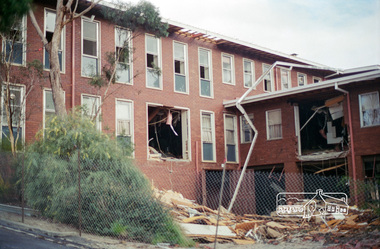 Eltham District Historical Society Inc
Negative - Photograph, Harry Gilham, Demolition of Eltham Shire Offices (North Wing viewed from Senior Citizens' Centre), 895 Main Road, Eltham, Aug. 1996
The Shire Offices opened in 1965 and were extended in 1971. The final Eltham Shire Council meeting was held in December 1994 before the forced amalgamations of municipal councils by the Kennett Government. The State-Government-appointed Commissioners (1994-1996) took the decision in July 1996 to demolish the Eltham Shire Offices. The demolition works started within 24 hours of the decision being made.Roll of 35mm colour negative film, 5 of 6 strips Associated colour printKodak Gold 100-5eltham shire office, demolition, shillinglaw trees -
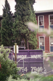 Eltham District Historical Society Inc
Negative - Photograph, Harry Gilham, Demolition of Eltham Shire Offices, 895 Main Road, Eltham, Aug. 1996
The Shire Offices opened in 1965 and were extended in 1971. The final Eltham Shire Council meeting was held in December 1994 before the forced amalgamations of municipal councils by the Kennett Government. The State-Government-appointed Commissioners (1994-1996) took the decision in July 1996 to demolish the Eltham Shire Offices. The demolition works started within 24 hours of the decision being made.Roll of 35mm colour negative film, 5 of 6 strips Associated printKodak Gold 100-5eltham shire office, demolition, shillinglaw trees -
Whitehorse Historical Society Inc.
Map, Belgium and part of France map WW1, Nov 1917
WW1 map of Ypres and Menin. Sheet 28 Edition 3 Scale 1: 40,000 Nov 1917non-fictionWW1 map of Ypres and Menin. Sheet 28 Edition 3 Scale 1: 40,000 Nov 1917world war 1914 - 1918, world war 1914 - 1918 battle of ypres, maps -
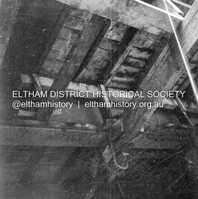 Eltham District Historical Society Inc
Negative - Photograph, J.A. McDonald, Bridge decking structure, Mar. 1960
Possibly Cherry Tree Road Job 56F443 Contractors Wolf and Wood Old bridge during construction of new bridge March 1960Record of various Shire of Eltham infrastructure works undertaken during the period of 1952-1962 involving bridge and road reconstruction projects, sometimes with Eltham Shire Council Project Reference numbers quoted. It was during this period that a number of significant improvements were made to roads and new bridges constructed within the shire that remain in place as of present day (2022). In many situations, the photos provide a tangible visible record of infrastructure that existed throughout the early days of the Shire. The album was put together by or under the direction of the Shire Engineer, J.A. McDonald.infrastructure, 1960-03, bridge construction, cherry tree road, heidelberg-kinglake road, shire of eltham -
Stawell Historical Society Inc
Map, Plan of the Principal Underground Workings at Stawell, 1894
Plan of the Principal Underground Workings at Stawellstawell, mining -
Stawell Historical Society Inc
Map, William, County of Borung, Shire of Stawell, 1945
William, County of Borung, Shire of Stawellstawell -
 Bendigo Historical Society Inc.
Legal record - Contract, 16/10/1952
Newsprint Contract between Messrs. Bowaters Sales Company Limited London and The Bendigo Advertiser Newspapers. Contract is for 10 years to purchase 280 long tons of newsprint per annum. Tan Foolscap folder and 3 pages of typewritten contract. Page three has a 6d Revenue Postage stamp attached. This entire item is held together by a pink ribbon through two punched Holes.bendigo advertiser, bowaters, newspapers -
 Eltham District Historical Society Inc
Negative - Photograph, Sketch; Sweeney's Cottage, Culla Hill, Eltham (n.d.), c.1970
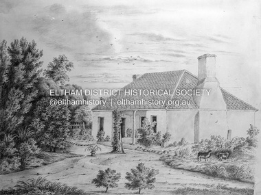
The original sketch was photographed in 1970 for reproduction in the Shire history publication Pioneers & Painters (1971). The very fragile original was kept in the Council stoungroom and suffered significant damage to its edges over the years, no doubt it has also yellowed. A comparison of the original as digitised (2022) with the negative taken 50 years earlier also reveals that the left 20% of the sketch has been cut off, probably due to damage. In June 1842 Thomas Sweeney applied to the Superintendent, C.J. La Trobe, asking permission to purchase a portion of the recently surveyed ‘Parish of Nillumbik'. His request was allowed and handed to the sub-treasurer and Land Board. He paid £110 for 110 acres and called the land 'Culla Hill'. He first built a temporary house, a slab hut 12 feet by 10 feet, in which he lived with his wife, an Irish girl whom he had married in 1838. (His first wife had been drowned at Port Jackson.) Some time later he built a permanent residence on the model of a Tipperary farmhouse. It was a rectangular building of hand-made bricks and stone quarried from the Western Hill with a recessed verandah in front, and bore a slate roof. The out-buildings consisted of a detached kitchen, stable and a barn. It was in this house that succeeding generations of Sweeneys were reared. The original slab hut became a washhouse and survived till recent years. 'Culla Hill' became a social centre for the district, church services being held there on various occasions. The first wheat crop in the district was planted by Sweeney who also supplied the first grain for a mill that later was built at Eltham. He took an active interest in the development of the district. At this time travelling people--many of them runaway sailors or convicts--often passed the settlement, and some of them stayed and worked with Sweeney. A tribe of aborigines living on the river below 'Culla Hill' were apparently on good terms with Sweeney, for it is said that they helped him with the building of his house. Very little is known about the aborigines who originally lived in the Eltham district. There must have been many of them; their stone axes, grinding stones, and anvil stones have been found in the gullies around Research and canoe trees and artifacts were found on the Kangaroo Ground hills. Early settlers remembered a tribe that camped on the site of the present railway bridge at Eltham. They held corroborees there and visited settlers for hand-outs of 'flour and bacca’. There was an aboriginal reserve on the Yarra, upstream from Eltham, but most of those who had collected there later went to live on the Pound Reserve at Warrandyte, where the last aborigines in the area finally ended their days. The Pound Reserve, of 1,103 acres, was established at Pound Bend in 1841. The chief protector, George Robinson, and his four assistants, were given instructions to care for the aged and sick, to provide blankets and rations for all who lived there, to train the able-bodied men in agriculture and other trades and to find them jobs. The Yarra blacks, who later came under the protection of William Thomas, have been described as a 'fine race, well made and above the average height'. Thomas Sweeney died on 6 September 1867 and was buried in the Eltham Cemetery. To his wife Margaret and his son John, he left the entire property of 'Culla Hill'. To his other son Patrick, he left 150 acres, including a small two-roomed wooden cottage. He had five daughters: Kate and Margaret (twins) who were born in 1842, Ellen 1846, Annie 1848 and Johanna 1851. John Sweeney farmed 'Culla Hill' until his death in 1909. He had ten children; one of them, Mary, became Mrs M. Carrucan whose son, Mr John Carrucan, still lives at Eltham. 'Culla Hill' passed out of the Sweeneys possession in 1939 and was renamed by its new owners, 'Sweeneys', in memory of its pioneers. - Pioneers & Painters: One Hundred Years of Eltham and its Shire, Alan Marshall 1971, pp10-12 4 x 5 inch black and white negative of original colour sketchculla hill, sweeey's cottage -
Stawell Historical Society Inc
Map, Stawell Gold Mine, SGM Mineralized System Longitudinal Projection showing Diamond Drilling Holes 2007, June 2007
Section of Big Hill showing Diamond Drill holes through Magdala, Magdala North and Golden Gift Ore bodies to 2000m levelLegend of Mine workings numbered. 1980's mining, gold, map -
 Eltham District Historical Society Inc
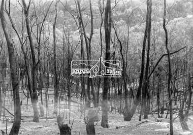
Negative - Photograph, Eltham - Laughing Waters area, 1965
Source: Geo. W. Bell, Eltham See "History of Bushfires in Nillumbik" page 43.This photo forms part of a collection of photographs gathered by the Shire of Eltham for their centenary project book,"Pioneers and Painters: 100 years of the Shire of Eltham" by Alan Marshall (1971). The collection of over 500 images is held in partnership between Eltham District Historical Society and Yarra Plenty Regional Library (Eltham Library) and is now formally known as the 'The Shire of Eltham Pioneers Photograph Collection.' It is significant in being the first community sourced collection representing the places and people of the Shire's first one hundred years.Digital image 4 x 5 inch B&W Negsepp, shire of eltham pioneers photograph collection, eltham, bushfire, laughing waters -
 National Vietnam Veterans Museum (NVVM)
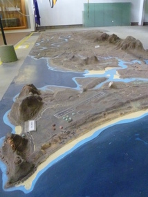
Map - Map, Relief, PHU
Raised relief map of Phuoc Tuy province. Six pieces showing land features from Long Hai hills to coast at Vung Tau baserelief map, phuoc tuy