-
 Ballarat Tramway Museum
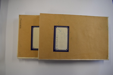
Negative - Set of 3, Campbell Duncan, 10/08/1971 12:00:00 AM
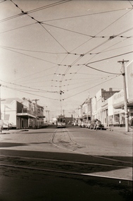
Yields information about tram operations and the street views at Stones Corner.Set of 3 photographs taken on 10/8/1971 by Campbell Duncan of trams in the Main of No. 31 approaching the junction with Bridge St and Victoria St. The tram has the destination of Gardens via Drummond North and a Twin Lakes sign. In the background are the Avery Scales store, Wearwell and Stones Corner. Shows the overhead arrangements at this location.trams, tramways, main road, stones corner, tram 31 -
 Melbourne Tram Museum
Negative, Wal Jack collection, c1930
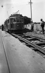
Black and white negative from Wal Jack collection of W 259 or W2 during track reconstruction work on its way to North Coburg. The tram has not been fitted with a route number box. A number of workmen in the view "leaning on their shovels" as the tram goes past. Photo could be between Moreland Road and Bell St or in Lygon St before the end of the cable trams in Sydney Road Coburg. OR - in Moreland Road itself, having just left Nicholson St - note heavy wires at the rear of the tram. Photo can be dated from the date a route number box was fitted. Tram was converted to a W2 in Oct. 1931. Photo c1930. Photo may not be by Wal Jack as a size that he did not use.trams, tramways, w2 class, w class, north coburg, sydney road, lygon st, trackwork, tram 259 -
 National Vietnam Veterans Museum (NVVM)
Map - Map, Vietnam
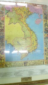
Colour map of vietnam and neighbouring countries with a decorative border of cultural aspects in a gilt framedonated by the Pham Family to National Vietnam Veterans Museum 9.03.2007map, vietnam -
 University of Melbourne, Burnley Campus Archives
Negative - Black and white negative, A Distinguished Guest?, 1922-1923
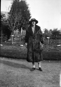
Black and white photograph. Woman wearing a splendid hat and full length fur coat standing on lawn in front of the Pavilion at Burnley.women, hat, fur coat, lawn, burnley gardens, j.l. provan, pavilion -
 Warrnambool and District Historical Society Inc.
Map - Fire Maps, Region 5 Fire Control Map, 1963
Two fire maps of south west Victoria.1 This is a rectangular piece of linen folded several times to form a packet with the front part covered with a brown card. The cover has a blue and white label. The map has a white base with red and green markings and red and black printing .2 As .1 abovenon-fictionTwo fire maps of south west Victoriafire maps, warrnambool history -
 Melbourne Tram Museum
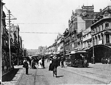
Negative, c1906
Copy negative of a photograph of cable cars in Bourke St at Swanston St with the Royal Mail Hotel in the background. Numerous cyclists and pedestrians. c1906.trams, tramways, cable trams, swanston st, bourke st -
 Stawell Historical Society Inc
Map, Landsborough, County of Kara Kara, 1954
Landsborough, County of Kara Karastawell -
 Eltham District Historical Society Inc
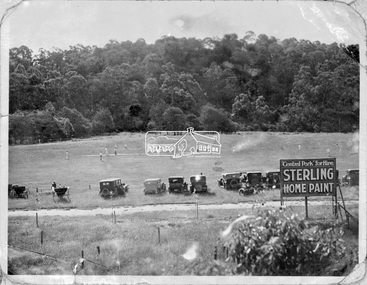
Negative - Photograph, Cricket match, Central Park, Eltham, c.1931
The new Central Park was opened on Monday, 21 April 1930 by Mr. W.H. Everard, M.L.A. followed by a sports carnival. The Advertiser reported on Friday, April 25, 1930 that – “Perfect weather prevailed on Monday for the sports gathering in aid of the recently-acquired park near the railway station, and from every point of view the day was a success. The Central Park contains 9½ acres, and has the Diamond Creek on one side and the railway line on the other. It cost £760, of which the council contributed £500, and the citizens, are finding the balance. Already about £80 has been spent in levelling, and a pavilion has been erected by the footballers, who will use the ground for training until it is sufficiently, improved for matches. There is ample shade along the banks of the creek, where there were numerous picnic parties. The committee has already done some planting on the railway side of the park, and where the trees grow on the higher side, overlooking the arena, the natural stand will have shade, command a view of the events, and have the trees on the banks of the creek in the distance. There were between 600 and 700 people present, many in motor cars having a little difficulty in, finding their way under the aqueduct to the ground, but the council is at present effecting improvements to the road. A merry-go round was a source of pleasure to the children, and the Northcote Soldiers and Citizens Band under Bandmaster Gore, de-lighted everyone with their varied selections of good music.” “Cr. E. J. Andrew, president of the Park Committee, said it was the first function held in the park, and although the citizens have guaranteed £420 towards it, there is still some-thing owing. Mr. W. H. Everard, M.L.A., who can always be relied upon to attend any gathering which draws the people together, said that he and Mrs. Everard had great pleasure in being present to declare the park open. He congratulated the Eltham people upon their public spirit, and the new park would be more appreciated in years to come. The other park is a splendid one, but it is far away, and one is required close to the station, so that young people can have a day's enjoyment, without having to go far from the station. The trouble in Victoria is not having enough parks. The early settlers did a lot in getting park lands, but the present generation is not doing enough. Eltham people are entitled to the highest commendation for their action, and Cr. Andrew and the council are to be thanked for what they have done. What is wanted is ingress and egress so that people can get in comfortably. When he was motoring in his wife said, "Surely you are not going down that precipice," and he replied that he would go anywhere where the people were. In the future it will be the big centre of Eltham.” Reproduced on page 96 of 'Pioneers & Painters'This photo forms part of a collection of photographs gathered by the Shire of Eltham for their centenary project book,"Pioneers and Painters: 100 years of the Shire of Eltham" by Alan Marshall (1971). The collection of over 500 images is held in partnership between Eltham District Historical Society and Yarra Plenty Regional Library (Eltham Library) and is now formally known as the 'The Shire of Eltham Pioneers Photograph Collection.' It is significant in being the first community sourced collection representing the places and people of the Shire's first one hundred years.Digital image 4 x 5 inch B&W Neg 9 x12.5 cm printsepp, shire of eltham pioneers photograph collection, eltham, eltham central park, automobile, central park, cricket match, pioneers and painters -
 Robin Boyd Foundation
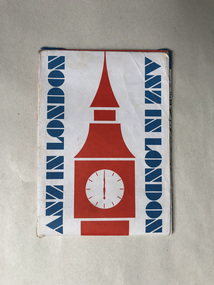
Map, ANZ in London; A map for visitors to London
walsh st library -
 Eltham District Historical Society Inc
Negative - Photograph, George W. Bell, Foot Bridge to Eltham High School, c.1960
Footbridge over the Diamond Creek at Dalton Street near Withers Way. It has since been replaced and integrated into the Wingrove Park Trail.This photo forms part of a collection of photographs gathered by the Shire of Eltham for their centenary project book,"Pioneers and Painters: 100 years of the Shire of Eltham" by Alan Marshall (1971). The collection of over 500 images is held in partnership between Eltham District Historical Society and Yarra Plenty Regional Library (Eltham Library) and is now formally known as the 'The Shire of Eltham Pioneers Photograph Collection.' It is significant in being the first community sourced collection representing the places and people of the Shire's first one hundred years.Digital image 4 x 5 inch B&W Negsepp, shire of eltham pioneers photograph collection, eltham, eltham high school, foot bridge, bridge, dalton street, diamond creek (creek), george w. bell collection, wingrove park trail, withers way -
Whitehorse Historical Society Inc.
Map, Schwerkolt property by Arthur Schwerkolt, 1993
Map of Schwerkolt property and rough plan of original stone house produced by Arthur Schwerkolt. Also copy of covering letterschwerkolt cottage -
Stawell Historical Society Inc
Map, Department of Mines Victoria, The Reefs. The Principle Reefs at Quartz Reefs, 1868
c1868 Map showing the position of principal Reefs at Quartz ReefsTracing Shewing the position of the principle reefs at Quartz Reefs. Scale 8 Chains to an inch mining, gold, map -
 Eltham District Historical Society Inc
Negative - Photograph, Russell Yeoman, Shire of Eltham War Memorial, Memorial Park, Garden Hill, Eltham-Yarra Glen Road, Kangaroo Ground, c.1980
Shire of Eltham War Memorial Tower at Kangarooo Ground; view from the east and close up of entrance including Honour Roll. On November 11th 1926 the Shire of Eltham War Memorial Tower at Kangaroo Ground was opened. It is regarded as one of Melbourne’s most outstanding lookout towers. It commands a magnificent 360 degree panorama from Kinglake across the Diamond Valley to Macedon and the You Yangs. It is built on a peak which was once a volcano, 237 metres above sea level. After World War one a memorial cairn was erected on the site, and in 1925 a committee of public-minded citizens began to plan for a tower. Many generous donations of material and money were forthcoming so that in 1926 the Governor General Lord Stonehaven was able to unveil the plaque before a crowd of 500 people There was some concern in the 1960s when the Forests Commission wanted to build a firespotters cabin on the top. At first R.S.L. branches opposed the idea, but it was realised that this use could combine with its use as a tourist attraction, and would ensure its maintenance for the future. Today the Kangaroo Ground tower provides one of the best views around Melbourne and is a fitting memorial to those who died in two world wars. From: Historic items for Diamond Valley Community Radio September 1990 (EDHS collection) On November 8th, 1951, the memorial was re-dedicated by the Governor of Victoria, Sir Dallas Brooks with the addition of the names of men from the Shire of Eltham who fell in the Second World War. Further wreaths were added subsequent to this image in time for the 2001 Reembrance Day service to commemorate the men from th shire who had fallen in the Malayan, Korean, Borneo and Vietnam campaigns.Roll of 35mm colour negative film, 2 strips Kodak Safety 5035 Colour print (x1)Kodak Safety 5035garden hill, kangaroo ground, kangaroo ground memorial, memorial park, shire of eltham war memorial, shire of eltham war memorial tower, war memorial, kangaroo ground relief committee -
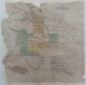 Federation University Historical Collection
Map, Lintons Pre-emptive Section, 1872
Printed map with coloured shading by F. W Niven Lydiard Street, Ballaratmap, mining districts, lintons claim, lintons diggings, f w niven, nivens steam lithographic machine, f.w. niven -
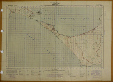
Whitehorse Historical Society Inc.
Map, Ringwood, 1935
Australia Ringwood and area map.Australia1:63,360 series map, Ringwood N.849 Zone 7. Scale 1 inch to 1 mile. Approximate scope: Prahran-Cockatoo, Lilydale-DandenongAustralia Ringwood and area map.maps, ringwood -
 Federation University Historical Collection
Map, Sorrento, 1931, 03/1931
Printed colour map on paper showing Sorrento and surroundssorrento, point nepean, point lonsdale, queenscliff, port phillip bay -
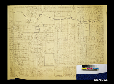 Whitehorse Historical Society Inc.
Map - Civic maps, City of Nunawading, City of Nunawading Maps
A collection of maps of the City of Nunawading from Diana Coles, City of Whitehorse Community Chest.8 printed maps of various sizes covering city of Nunawading. Scale 1:2500non-fictionA collection of maps of the City of Nunawading from Diana Coles, City of Whitehorse Community Chest. coles diana, civic maps, city of nunawading, whitehorse road, blackburn road -
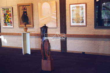
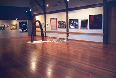
 Eltham District Historical Society Inc
Negative - Photograph, Art show, Eltham Community Centre, c.1994
An art auction for the Save the Copper Butterfly campaign arranged by Pauline Toner was held in 1987 at which a number of which were acquired by the Shire of Eltham for the Eltham Art Collection, now part of the Nillumbik Art Collection. This show circa 1994 in the Eltham Community Centre displayed several of the works.Roll of 35mm colour negative film, 1 stripKodak Gold 100-4art exhibition, eltham community centre, eltham copper butterfly, nillumbik art collection, adriane strampp -
 Eltham District Historical Society Inc
Negative - Photograph, Art show, Eltham Community Centre, c.1994
Art show held in the Eltham Community CentreRoll of 35mm colour negative film, 1 stripKodak Gold 100-4art exhibition, eltham community centre -
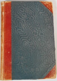 Bendigo Historical Society Inc.
Legal record - Letter Book
Letter Book with alphabetised index for the duration 3/06/1872 to 15/10/1872 - not attributed to any organisation / office (more research required). Register covers assigned letter number and brief description registered as 72/2028 to 72/5689 (over pages 3 to 444), handwritten in black ink. Letters cover a broad range of topics / responses such a "no objection". Green heavy card covers with red faux leather spine and worn corners.Spine marked Letter Book, 3/06/1872 to 15/10/1872.letter book, solicitor -
University of Melbourne, Burnley Campus Archives
Map, City of Kew, Hyde Park, c. 1970
(1) Photocopy of hand drawn plan of park showing contours. No 7/3. Scale 1 inch:40 ft. (2) Map 45 from Melway with Hyde Park highlighted.kew, hyde park -
 Eltham District Historical Society Inc
Negative - Photograph, J.A. McDonald, Heidelberg-Kinglake Road, Sep. 1960
Looking north from south boundary of St Andrews Township (Cr. Brinkkotter in car) Noted on album page as September 1960 but photo dated October on reverseRecord of various Shire of Eltham infrastructure works undertaken during the period of 1952-1962 involving bridge and road reconstruction projects, sometimes with Eltham Shire Council Project Reference numbers quoted. It was during this period that a number of significant improvements were made to roads and new bridges constructed within the shire that remain in place as of present day (2022). In many situations, the photos provide a tangible visible record of infrastructure that existed throughout the early days of the Shire. The album was put together by or under the direction of the Shire Engineer, J.A. McDonald.infrastructure, shire of eltham, bridge construction, road construction, cr. a. brinkkotter, heidelberg-kinglake road, st andrews, 1960-09 -
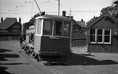 Melbourne Tram Museum
Negative - Set of 3, Wal Jack, 19/01/1941 12:00:00 AM
Set of three Black and white negatives of No. 7 (Water car) or flusher at Hawthorn Tram Depot. .1 - Entering the depot, passing the depot starters office - note the clock on the wall. .2 - Entering the shed, passing a W2 .3 - Inside the shed. Photo dated 19-1-1941 in the Wal Jack album along with details of the location.trams, tramways, hawthorn depot, work trams, tram 7 -
 Eltham District Historical Society Inc
Negative - Photograph, Art show, Eltham Community Centre, c.1994
Art show held in the Eltham Community CentreRoll of 35mm colour negative film, 1 stripKodak Gold 100-4art exhibition, eltham community centre -
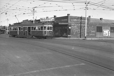 Melbourne Tram Museum
Negative, Wal Jack, 21/08/1941 12:00:00 AM
Black and white negative, by Wal Jack, of W2 442 (Moreland, Route 15) with Paltaro Dry cleaners in the background and a shop selling Black and White Cigarettes and advert for the Liberty Theatre in Lygon St. Photo dated 21-8-1941 in the Wal Jack album along with details of the location.trams, tramways, holmes st, moreland road, w2 class, moreland, route 15, tram 442 -
Whitehorse Historical Society Inc.
Map, Cadastral Map System, 2005
Land Victoria map of section of Blackburn North.Land Victoria map of section of Blackburn North, inc. Middleborough Road, Joseph Street and Chapman Street. Scale: 1:1500. With Lot Nos. and block frontage dimensions.Land Victoria map of section of Blackburn North. middleborough road, blackburn north, joseph street, blackburn north, chapman street, blackburn north -
Glenelg Shire Council Cultural Collection
Negative - NEgative - Portland Botanic Gardens and Lifeboat Shelter, c. 1934
NEGATIVE FOR BLACK AND WHITE PHOTOGRAPH. Portland Botanic Gardens. The Portland Lifeboat shelter is visible from the front view, showing plaque.negative, portland lifeboat, botanic gardens -
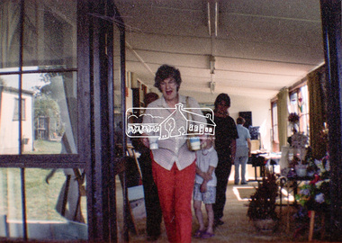 Eltham District Historical Society Inc
Negative - Photograph, Open Day, Eltham Living and Learning Centre, 7 Nov 1987
Open Day, Eltham Living and Learning Centre, part of the Eltham Community Festival activites, 7 Nov. 1987eltham, eltham festival, eltham living and learning centre, living and learning centre, open day -
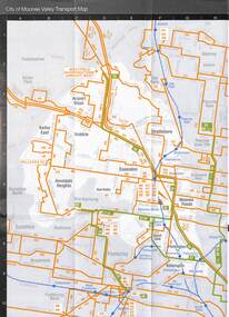 Melbourne Tram Museum
Map, Metlink, "Your Guide to Melbourne's Public Transport System - City of Manningham", "City of Moonee Valley", c2005
Map - 18 fold - 6x3 - pocket size, printed in full colour, titled "Your Guide to Melbourne's Public Transport System - City of Manningham", published by Metlink c2005. Has a map of transport routes in the City of Manningham, details of Metcards, bus routes, maps of the tram and train network and Metcard agents. .2 - as for .1, but for the City of Moonee Valleytrams, tramways, maps, city of manningham, city of moonee valley -
 Greensborough Historical Society
Map, Melbourne and Metropolitan Board of Works. Survey Division, MMBW, Yarra 2500 / 15.24. Diamond Creek, Grassy Flat Road, 1978_02
Melbourne and Metropolitan Board of Works. Yarra 2500 [base map] 15.24. Diamond Creek, Grassy Flat Road. Parish of Nillumbik 3310. Municipality of Diamond Valley 257. Prominent streets include: Everleigh Drive, Broad Gully Road and Clyde Street. Features include the Diamond Creek, Nillumbik Park and Diamond Creek Reservoir.MMBW Map in 1:2500 [scale] series. Cream parchment with green tape reinforcing on edges and punched holes on left edge.mmbw, melbourne and metropolitan board of works, diamond creek - maps, shire of diamond valley