-
 Ringwood and District Historical Society
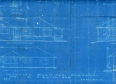
Plan, Architects plan for residence in Balfour Avenue, Heathmont for Stan Wieland , no date
Stanley Wieland took over the property called "Fairview" at the corner of Dickasons Road and Canterbury Road, Heathmont after his Father's death in 1945. He married Thelma Wilson in 1930. Their daughter Pat wrote the Wieland History with her husband Don Talbot.Architect's plan on heavy blue paper for residence at Balfour Avenue , Heathmont -
 Kew Historical Society Inc
Plan, Melbourne & Metropolitan Board of Works : Borough of Kew : Detail Plan No.1582, 1904
The Melbourne and Metropolitan Board of Works (MMBW) plans were produced from the 1890s to the 1950s. They were crucial to the design and development of Melbourne's sewerage and drainage system. The plans, at a scale of 40 feet to 1 inch (1:480), provide a detailed historical record of Melbourne streetscapes and environmental features. Each plan covers one or two street blocks (roughly six streets), showing details of buildings, including garden layouts and ownership boundaries, and features such as laneways, drains, bridges, parks, municipal boundaries and other prominent landmarks as they existed at the time each plan was produced. (Source: State Library of Victoria)This plan forms part of a large group of MMBW plans and maps that was donated to the Society by the Mr Poulter, City Engineer of the City of Kew in 1989. Within this collection, thirty-five hand-coloured plans, backed with linen, are of statewide significance as they include annotations that provide details of construction materials used in buildings in the first decade of the 20th century as well as additional information about land ownership and usage. The copies in the Public Record Office Victoria and the State Library of Victoria are monochrome versions which do not denote building materials so that the maps in this collection are invaluable and unique tools for researchers and heritage consultants. A number of the plans are not held in the collection of the State Library of Victoria so they have the additional attribute of rarity.Original survey plan, issued by the MMBW to a contractor with responsibility for constructing sewers in the area identified on the plan within the Borough of Kew. The plan was at some stage hand-coloured, possibly by the contractor, but more likely by officers working in the Engineering Department of the Borough and later Town, then City of Kew. The hand-coloured sections of buildings on the plan were used to denote masonry or brick constructions (pink), weatherboard constructions (yellow), and public buildings (grey). Public buildings, coloured grey on the Plan 1582 include the police station and post office, churches and schools. The earliest church school, Common School No.356 was located at the rear of the Congregational Church in Peel Street. It was constructed in 1859. The first buildings of Kew Primary School No.1075 on the other side of Peel Street were constructed in 1871. The school in 1903 only occupied a small fraction of its current site. In 1903, where the rear playground is now located, were two weatherboard and one brick villa. Trinity Grammar School was founded in 1902 and opened in the Parish Hall at the rear of Holy Trinity Anglican Church. It was not to move to its current site until 1906. The outline of the building housing the Kew Fire Brigade in the centre of the north side of Walton Street is shown but not named on the plan. Further down Pakington Street stood the two-storey Italianate mansion ‘Overton’. The home of Stanford Chapman, it was to be featured in the Imperial Institute series of bromide photographs of Victoria, Vol. 1: Homes and scenery. It was later to become a boarding house before it was later demolished.melbourne and metropolitan board of works, detail plans, maps - borough of kew, mmbw 1582, cartography -
 Wodonga & District Historical Society Inc
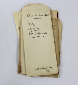
Legal record - Haeusler Collection Personal Family Papers c.1920s
Personal papers relating to the affairs of the Haeusler family, including a probate will and financial documents. This item has well documented provenance and a known owner. It forms part of a significant and representative historical collection which reflects the local history of Wodonga. It contributes to our understanding of domestic and family life in early twentieth century Wodonga, as well as providing interpretative capacity for themes including local history and social history.A stack of papers with handwriting in black ink. haeusler, haeusler collection, germany, wodonga, paperwork, administration, family, social history -
 Eltham District Historical Society Inc
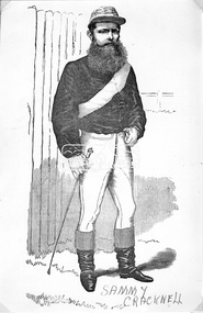
Negative - Photograph, Australian Sporting Celebrities, Sammy Cracknell, Jockey, 1887
Jockey Sammy Cracknell was born Norfolk, England, 1847. Image copied from 'Australian Sporting Celebrities' - page 56, 1887. Reproduced on page 37 of 'Pioneers & Painters'This photo forms part of a collection of photographs gathered by the Shire of Eltham for their centenary project book,"Pioneers and Painters: 100 years of the Shire of Eltham" by Alan Marshall (1971). The collection of over 500 images is held in partnership between Eltham District Historical Society and Yarra Plenty Regional Library (Eltham Library) and is now formally known as the 'The Shire of Eltham Pioneers Photograph Collection.' It is significant in being the first community sourced collection representing the places and people of the Shire's first one hundred years.Digital image 4 x 5 inch B&W Neg B&W Print (x2) 25 x 20 cm sepp, shire of eltham pioneers photograph collection, sammy cracknell, jockey, pioneers and painters -
 University of Melbourne, Burnley Campus Archives
Plan, Richmond Primary School 'Prep Garden', 1994
(1) Coloured Section Elevation and Detail Suggestion by Frances Saunders August 1994. (2) Coloured Preliminary Plan, Landscape Graphics by Rachel Dann dated 16.8.94. Scale 1:50. (3) Site Analysis & Inventory. Scale 1:50. (4) 2 copies, 1 coloured, Section Elevations by N. Herzberg. Scale 1:50. (5) Coloured plan, Secret Garden by Julie Tydens p3 of 3 dated 22.8.94. Scale 1:50. (6) Coloured Preliminary Plan by Jacinta Chong Sheet 3 of 3 dated 22 Aug 1994. Scale 1:100. (7) 2 tracing paper and 1 paper Site Plan drawn by JK. Scale 1:50 and 1:100. (8) Coloured Section Elevation for Landscape Graphics by Rachel Dann dated 22.08.1994. Scale 1:50. (9) Coloured Preliminary Plan dated August 1994 by Frances Saunders. Scale 1:100. (10) Preliminary Plan Sheet No 3 of 3 dated 18.08.1994 by Ian Porterfrances saunders, rachel dann, julie tydens, jacinta chong, ian porter, richmond primary school, gardens, jill kellow -
Bendigo Historical Society Inc.
Plan - MARKS COLLECTION: SIDE AND FLOOR PLAN FORTUNA VILLA
Laminated plan, hand coloured, with side elevations and floor plans of Fortuna Villa entrance area. Basement, ceiling and first floor plans, with side elevations labelled Section A,B and (front view ) Section C,D. On bottom of plan signed 'W. Beebe Architect' and 1/4' equals 1 foot.bendigo, buildings, fortuna villa -
University of Melbourne, Burnley Campus Archives
Plan, Mary Younger, Proposed Outdoor Eating Area, Student Amenities Block, Vic. College of Agriculture & Horticulture, 1999
Plan of proposed outdoor eating area, Student Amenities Block. Accompanying letter from Mary Younger, Architect, refers to this being a revised drawing and is accompanied by copy (X2) of Australian Standard "Design for access and mobility". AS 1428.1-1998 and 1428.2-1992. See also B18.0006.mary younger, amenities, vcah, burnley -
 Eltham District Historical Society Inc
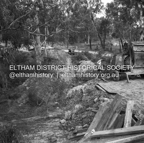
Negative - Photograph, J.A. McDonald, Henley Road at Watsons Creek, Apr. 1961
Henley Road at Watsons Creek looking easterly along centreline from west abutment Early April 1961Record of various Shire of Eltham infrastructure works undertaken during the period of 1952-1962 involving bridge and road reconstruction projects, sometimes with Eltham Shire Council Project Reference numbers quoted. It was during this period that a number of significant improvements were made to roads and new bridges constructed within the shire that remain in place as of present day (2022). In many situations, the photos provide a tangible visible record of infrastructure that existed throughout the early days of the Shire. The album was put together by or under the direction of the Shire Engineer, J.A. McDonald.infrastructure, shire of eltham, bend of islands, cr. charis pelling, henley road, henley road bridge, kangaroo ground, oxley bridge, watsons creek, w.e. wolf, bridge construction, road construction, 1961-04 -
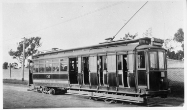
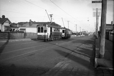 Melbourne Tram Museum
Negative, Wal Jack, 20-4-1945?
Black and white negative, by Wal Jack, of S 165 in Droop St at White St, with the Footscray Fire Station on the right of the photograph. S 165 has the "Special E" destination indicating it was on an Explosive factory working. In front of the tram is a X1 class. Photo not dated in Wal Jack album, c1943. Could be the same date as Reg Item 5446 - 20-4-1945.trams, tramways, droop st, footscray, world war 2, special e, s class, x1 class, tram 165 -
 Kew Historical Society Inc
Plan - Subdivision Plan, Kewdene Estate, 1937-1939
Pru Sanderson, in her groundbreaking ‘City of Kew Urban Conservation Study : Volume 2 - Development History’ (1988), summarised the periods of urban development and subdivisions of land in Kew. The periods that she identified included 1845-1880, 1880-1893, 1893-1921, 1921-1933, 1933-1943, and Post-War Development. These periods were selected as they represented periods of rapid growth or decline in urban development. An obvious starting point for Sanderson’s groupings involved population growth and the associated economic cycles. These cycles also highlighted urban expansion onto land that was predominantly rural, although in other cases it represented the decline and breakup of large estates. A number of the plans in the Kew Historical Society’s collection can also be found in other collections, such as those of the State Library of Victoria and the Boroondara Library Service. A number are however unique to the collection.The Kew Historical Society collection includes almost 100 subdivision plans pertaining to suburbs of the City of Melbourne. Most of these are of Kew, Kew East or Studley Park, although a smaller number are plans of Camberwell, Deepdene, Balwyn and Hawthorn. It is believed that the majority of the plans were gifted to the Society by persons connected with the real estate firm - J. R. Mathers & McMillan, 136 Cotham Road, Kew. The Plans in the collection are rarely in pristine form, being working plans on which the agent would write notes and record lots sold and the prices of these. The subdivision plans are historically significant examples of the growth of urban Melbourne from the beginning of the 20th Century up until the 1980s. A number of the plans are double-sided and often include a photograph on the reverse. The advertisement for the ‘Kewdene Estate’ subdivision is pasted over a photograph of a property for sale. This is typical of the reuse of promotional materials in the period during, and subsequent to World War I. The subdivision included 14 lots bordered by Belmore Road, Birtles Street and Giles Street. On the other side of the subdivision [Glass] Creek is noted. The subdivision plan also shows part of the Outer Circle Railway and Deepdene Railway Station.subdivision plans - east kew, kewdene estate, belmore road -- kew east (vic.), giles street -- kew east (vic.) -
 Kew Historical Society Inc
Education kit - Educational kit, Cuisenaire Company Australia, Original Cuisenaire (R) Numbers in Colour, 1970-1975
This Mathematics learning aid was made in Australia by the Cuisenaire Company of Australia under licence . These wooden number rods were invented by Belgium school teacher Georges Cuisenaire, who wrote a book about them in 1952 (Les Nombres en couleurs). Cuisenaire rods with booklet and box, wood / metal / paper, made by the Cuisenaire Company, Australia, 1965-1980. This object consists of a sheet metal box, containing 10 compartments, each with a single size of wooden blocks in different colours. The shortest block is 1 cm long, next 2 cm, etc., longest is 10 cm long. ORIGINAL CUISENAIRE (R) NUMBERS IN COLOUR / (R) MADE IN AUSTRALIA UNDER MR CUISENAIRE'S LICENCE BY CUISENAIRE CO OF AUSTRALIA P/Lcuisenaire, educational resources, mathematics learning aids -
 Melbourne Tram Museum
Negative, Wal Jack, c1940
Black and white negative by Wal Jack of W3 659 (Toorak Route 8) in Victoria St, shunting. Has the Army Recruiting centre in the background and a building advertising Goodyear tyres and tubes. Photo undated, c1940.trams, tramways, victoria st, route 8, shunting, w3 class, tram 659 -
University of Melbourne, Burnley Campus Archives
Plan, Kate Blood, City of Werribee Proposal for a Monument to Mark the Proclamation of Werribee as a City, 1987
Coloured elevation by Kate Blood dated 16.04.1987kate blood, werribee -
Ringwood and District Historical Society
Legal record - Fire Insurance document (C.E.Carter), Fire Insurance - Atlas Assurance Co Ltd for J. E. M. Williams, 1934
Standard form of Fire Insurance Policy issued by Atlas Assurance Company Limited, England.Policy issued to J. E. M. Williams for property in Main Street Ringwood, dated September 1934. -
Northern District School of Nursing. Managed by Bendigo Historical Society Inc.
Negative - Lecture theatre opening
The Northern District School of Nursing opened in 1950 in to address the issues around nurse recruitment, training and education that had previously been hospital based. The residential school was to provide theoretical and in-house education and practical training over three years. The students would also receive practical hands-on training in the wards of associated hospitals. The Northern District School of Nursing operated from Lister House, Rowan Street, Bendigo. It was the first independent school of nursing in Victoria and continued until it closed in 1989.Two photographic negatives of the Lecture Theatre opening NDSN lunch - all staff. NDSN Lecture Theatre opening NDSN lunch - all staff.ndsn, nursing, uniforms -
Port Melbourne Historical & Preservation Society
Plan - Tide limits at Inner East berth Station Pier for Tasmanian ferry Abel Tasman, Engineering Division, Port of Melbourne Authority, 1984
Plan: Tasmanian ferry at Inner East Station Pier - tide limits at working draft (highest tide). This plan relates to the vessel Abel Tasmanmelbourne harbor trust - port of melbourne authority, piers and wharves - station pier, abel tasman -
Federation University Historical Collection
Negative, Launch of Unigold Beer, 11/2001
chantelly jolly, david walters, unigold beer, mike downs, brewing -
Port Melbourne Historical & Preservation Society
Plan - Danks Street from Pickles Street to Esplanade East, Town of Port Melbourne, 28 Feb 1893
Plan of Danks Street, from Pickles Street to Esplanade East and bearing the seal of the Borough of Port Melbourne as well as agreement to contract to carry out works.A.V. Heath (Town Surveyor):Michael Minahan (?) (Contractor):J.J. Bartlett (Mayor):Prohasky (Councillor):E.C. Crockford (Town Clerk):W. Harrison (Witness)engineering - roads streets lanes and footpaths, engineering - fences, local government - borough of port melbourne, arthur victor heath, james john bartlett, william henry prohasky, edward c crockford, town clerks, w harrison, michael minahan -
Moorabbin Air Museum
Plan (item) - Bristol Aeroplane 170 schematic drawings, Gusset Outer Wing
Bristol Aeroplane Comany Ltd -
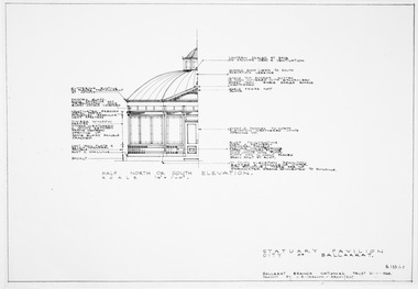 Friends of Ballarat Botanical Gardens History Group
Plan, J.B Vernon et al, City of Ballaarat Statuary Pavilion at the Gardens - Part B, September 1970
Sections, elevations and floor plan for pavilionPhotocopyplan, drawings, statuary pavilion -
Glenelg Shire Council Cultural Collection
Plan - Plans / Line Drawings - Port of Portland Authority, Steel work boat, Victoria, n.d
PORT OF PORTLAND AUTHORITYFront: '7'- black texta, top right corner -
Moorabbin Air Museum
Plan (item) - Bristol Aeroplane 170 schematic drawings, Installation of Bolts -Rear Spar Top Boom
Bristol Aircraft Company Ltd -
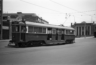
 Melbourne Tram Museum
Negative, Wal Jack collection, c1926 or earlier
Black and white copy negative from Wal Jack collection of O class 130, northbound on possibly a single track alongside the Brighton Cemetery in Hawthorn Road, north of North Road. Photo is in the PRO H collection. Cars sold to Adelaide in 1/1927trams, tramways, o class, hawthorn road, cemetery, tram 130, mmtb -
Glenelg Shire Council Cultural Collection
Plan - Plan - Port of Portland Slipway Tug Boat 'Buccaneer', 02/10/1989
port of portland -
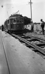 Melbourne Tram Museum
Negative, Wal Jack collection, c1930
Black and white negative from Wal Jack collection of W 259 or W2 during track reconstruction work on its way to North Coburg. The tram has not been fitted with a route number box. A number of workmen in the view "leaning on their shovels" as the tram goes past. Photo could be between Moreland Road and Bell St or in Lygon St before the end of the cable trams in Sydney Road Coburg. OR - in Moreland Road itself, having just left Nicholson St - note heavy wires at the rear of the tram. Photo can be dated from the date a route number box was fitted. Tram was converted to a W2 in Oct. 1931. Photo c1930. Photo may not be by Wal Jack as a size that he did not use.trams, tramways, w2 class, w class, north coburg, sydney road, lygon st, trackwork, tram 259 -
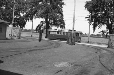 Ballarat Tramway Museum
Negative, Wal Jack, early 1960's
Yields information about Ballarat No. 17 passing the SEC depot in Wendouree Parade during the early 1960's.Negative and Digital images of the Wal Jack Ballarat Negative file of No. 17 passing the depot in Wendouree Parade carrying passengers. Has an Electric Cooking Roof advert. Photo shows the cycle rack. Photo early 1960's.trams, tramways, depot, wendouree parade, tram 17 -
 Kew Historical Society Inc
Plan, Sydney Arnold Best & Co, Field Place, Kew, c.1929
Pru Sanderson, in her groundbreaking ‘City of Kew Urban Conservation Study : Volume 2 - Development History’ (1988), summarised the periods of urban development and subdivisions of land in Kew. The periods that she identified included 1845-1880, 1880-1893, 1893-1921, 1921-1933, 1933-1943, and Post-War Development. These periods were selected as they represented periods of rapid growth or decline in urban development. An obvious starting point for Sanderson’s groupings involved population growth and the associated economic cycles. These cycles also highlighted urban expansion onto land that was predominantly rural, although in other cases it represented the decline and breakup of large estates. A number of the plans in the Kew Historical Society’s collection can also be found in other collections, such as those of the State Library of Victoria and the Boroondara Library Service. A number are however unique to the collection.The Kew Historical Society collection includes almost 100 subdivision plans pertaining to suburbs of the City of Melbourne. Most of these are of Kew, Kew East or Studley Park, although a smaller number are plans of Camberwell, Deepdene, Balwyn and Hawthorn. It is believed that the majority of the plans were gifted to the Society by persons connected with the real estate firm - J. R. Mathers and McMillan, 136 Cotham Road, Kew. The Plans in the collection are rarely in pristine form, being working plans on which the agent would write notes and record lots sold and the prices of these. The subdivision plans are historically significant examples of the growth of urban Melbourne from the beginning of the 20th Century up until the 1980s. A number of the plans are double-sided and often include a photograph on the reverse. A number of the latter are by noted photographers such as J.E. Barnes.An unnamed subdivision in Studley Park including five lots for sale in Studley Park Road, Highfield Grove and Tara Avenue. Unidentified on the plan, but clearly existing, are the Henty family mansion of Field Place and Tara Hall in Studley Park Road. The first attempted subdivision of Tara Hall was advertised in 1927 in which Lots 5, 6 and 7 in this plan were also advertised. Unusually, Lot 2 in Studley Park Road was created from the northern part of the Henty mansion, rather than Tara Hall. In the subdivision, lots were advertised at varying prices, with the highest price for land being Lot 2 in Studley Park Road. The plan notes that only one villa is to be allowed on each allotment.subdivision plans - kew, field place subdivision -- studley park – kew (vic.), highfield grove – kew (vic.), tara avenue – kew (vic.) -
 Queenscliffe Maritime Museum
Negative - Lifeboat QUEENSCLIFFE - sails being lifted, Lifeboat QUEENSCLIFFE, 1949
Lifeboat QUEENSCLIFFE crew, Ferrier brothersLifeboat QUEENSCLIFFENegative - Ferrier brothers raising a sail on QUEENSCLIFFE c1945Reverse - " NIL "historical references, lifeboat, queenscliffe lb, the time, ferrier -
Glenelg Shire Council Cultural Collection
Negative - Glass Plate Negative - Coastline looking towards Cape Grant, 1890-1910
Glass plate negative. Costline looking towards Cape Grant. -
 Eltham District Historical Society Inc
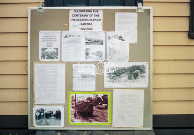
Negative - Photograph, Harry Gilham, Display celebrating the Centenary of the Heidelberg-Eltham Railway 1902-2002, Local History Centre, 728 Main Road, Eltham, c.Apr 2002
One of two display panels prepared by Eltham District Historical Society for display in the Eltham Railway Station foyer on 5 June 2002 along with handouts explaining the significance of the occassion to train passengers. In addition, Harry Gilham presented a talk on the history of the railway at the Sociiety's May 8th meeting.728 main road, activists, centenary celebrations, display, display panel, eltham district historical society, heidelberg-eltham railway extension, local history centre, lockup